
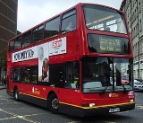
London Buses route 36
Encyclopedia
London Buses route 36 is a Transport for London
contracted bus route in London
, United Kingdom
. The service is currently contracted to Go-Ahead London
.
and Victoria, was taken over by the London General Omnibus Company
(LGOC). At the same time, it was extended from Victoria to Liverpool Street Station
via Vauxhall Bridge
, Harleyford Road, Oval
, Kennington Park Road, Borough, London Bridge
and Bank
and given the route number 36. The extension to Liverpool Street was short-lived being withdrawn after service on 14 March 1912, when the route was cut back to run West Kilburn to Victoria. Quite soon after on 20 June 1912, the 36 was extended to Catford
(St. Laurence Church) via Vauxhall Bridge, Harleyford Road, Oval, Camberwell New Road, Camberwell Green
, Peckham Road, New Cross
, Lewisham
and Rushey Green
.
As from 22 June 1914, the 36 was further extended from Catford to Hither Green Station
, after which the route became very stable. On 4 December 1916, it was supplemented by two new routes, mainly to serve war-workers; the 36A West Kilburn to Grove Park via Burnt Ash Hill and Baring Road; the 36B West Kilburn to Woolwich
(Earl of Chatham) via Lee High Road, Academy Road and Woolwich Common, with some journeys being extended to Plumstead
. The 36B was withdrawn in March 1917, but the 36A lasted through the war and was withdrawn on 7 April 1919 being replaced by a new route 39
. The withdrawal of the 36A was not popular and the route was re-instated on 3 September 1919. Also at this time the 36 was extended from West Kilburn to Willesden (Pound Lane) on Sundays only. This extension being withdrawn after service on 22 February 1920. A year later on 23 March 1921, the 36A was re-routed at Oxford Street
to run via Baker Street and Park Road to Camden Town
.
responsible for bus operation and route numbering in London. The new system was designed to make route numbering easier to understand for the travelling public. In fact, the reverse was the result, as can seen by the following list of the routes that replaced the 36 and 36A, which by this time was again working from West Kilburn.
36 group routes:
36 remained 36, 36A renumbered 136. This was further complicated in that these routes had short working suffixed routes. The plain route number being only used for journeys for the whole length of the route. As from 1 December 1924. 36 West Kilburn to Hither Green; 36A Victoria - Hither Green; 136 West Kilburn - Grove Park. This was changed as from 8 April 1925, when short-working routes were added:- 36B Victoria - Catford; 36C Harrow Road - Lewisham; 36D Camberwell Green - Hither Green; 36E West Kilburn - Catford and 36F West Kilburn -Peckham. The 136 was also revised as follows:- 136 West Kilburn - Grove Park renumbered 136A; New short-workings 136B West Kilburn - Lewisham; 136D Lewisham - Bromley Common; the 136 Wembley Exhibition - Bromley Common and 136C Wembley Exhibition - Grove Park were both registered but were not operating.
From 1925 the 36/136 group of routes also was covered by the "Independent operator" "City" 536 group of routes:- 536 Highgate (Underground Station)
- West Wickham
; 536A Highgate - Southend Village; 536C Highgate - Elmers End
. These services were later taken over by London Transport.
This situation remained until 3 October 1934, when the newly constituted London Passenger Transport Board
instituted its own numbering system, which generally re-instated the situation previous to December 1924, apart for routes 136 and 536, which by then had developed into self-contained routes, thereby keeping their identities. The 36 West Kilburn - Hither Green Station daily and 136 West Kilburn - Southborough
daily. The 536 was also re-numbered, becoming what is today's route 137
.
Up to the Second World War everything stayed the same, apart from 17 April 1936, when the 136 was withdrawn between Grove Park and Southborough, being replaced by a new route 94. On 21 November 1939, the 136 was withdrawn between Victoria and Grove Park, being re-routed to terminate at Victoria Coach Station
, the evening service on this route also being withdrawn at this time. As from 20 March 1940, the 136 was withdrawn completely. Due to wartime restrictions on the railways, a supplementary "express service" on the 36 between Hither Green and Victoria, running non-stop between Lewisham and Victoria, was introduced on 24 October 1940. This supplementary service was withdrawn on 18 March 1941. During the last three winters of the war, the 36 was withdrawn evenings, between Lewisham and West Kilburn; from 28 October 1942 until 20 April 1943; 28 October 1943 until 20 April 1944; 27 October 1944 until 2 May 1945.
, which was lost in 1937 when the 137 (a derivative of the 36) was withdrawn between Hyde Park Corner
and Bromley
.
Stage six of the Tram replacement programme occurred on 5 January 1952, tram route 54 Victoria - Grove Park, which complemented the 36 for much of its route, was replaced by a new bus route 69 which also ran Victoria - Grove Park. Six years later, in the aftermath of the busman's strike of 1958, London Transport was looking for economies in its operations. As from 26 November 1958, the 69 was re-numbered 36B and extended on Sundays to run West Kilburn - Grove Park. This allowed more flexibility in the 36 schedules.
On Thursday 24 August 1961, a gun and five boxes of ammunition were found under the rear seat of a 36A bus in Peckham garage. The gun was identified as that used to kill Michael Gregsten and wound Valerie Storie in the 'A6 murder case', for which James Hanratty
was hanged.
The 36 used London's first bus lane, southbound on Vauxhall Bridge, which came into use as from 26 February 1968. Originally using the centre lane of the bridge, this first bus lane was removed to the kerbside as from 1974 but was re-established in the centre of the road southbound in 2004 with the redevelopment of Vauxhall Cross (see Vauxhall bus station
).
Although the 36A and 36B lost their northern ends, the 36 survived unaltered until April 1991, when the section between Hither Green and Lewisham was transferred to route 180. The 36B was cut back to Peckham
and renumbered 136 in the March 1994 scheme. Then from 8 March 2003 the 36 was further shortened to start from New Cross
; the outer section from Lewisham to Paddington
being converted to cashless articulated buses under the 436 number.
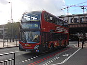 Despite the route reductions of the last decade, the 36 is still a comparatively long route through some very congested areas of London, with an end to end running time of over one and a half hours. It is also one of very few routes still to cross central London, carrying people in to the centre from both ends of the route, and requires the use of over 40 buses.
Late on 9 June 2008, as 63 year old man was killed after being hit by a route 36 bus in Edgware Road near the junction with Seymour Street. The victim was pronounced dead at the scene. The driver was taken off shift for routine enquiry, but not arrested. Edgware Road was closed for about eight hours from 2140 to 0600 the following day (Tuesday).
There were also in London:
Transport for London
Transport for London is the local government body responsible for most aspects of the transport system in Greater London in England. Its role is to implement the transport strategy and to manage transport services across London...
contracted bus route in London
London
London is the capital city of :England and the :United Kingdom, the largest metropolitan area in the United Kingdom, and the largest urban zone in the European Union by most measures. Located on the River Thames, London has been a major settlement for two millennia, its history going back to its...
, United Kingdom
United Kingdom
The United Kingdom of Great Britain and Northern IrelandIn the United Kingdom and Dependencies, other languages have been officially recognised as legitimate autochthonous languages under the European Charter for Regional or Minority Languages...
. The service is currently contracted to Go-Ahead London
Go-Ahead London
Go-Ahead London is the trading name used collectively for the London bus operations of the Go-Ahead Group. The name first appeared in August 2008, before which the company had traded under separate names and brands...
.
The Beginning
The 36 is a very long standing service, dating back to 6 April 1911 when the daily service on the previously un-numbered "Great Eastern" route between West Kilburn (Falcon), the traditional name for this terminus in Queens ParkQueen's Park (London)
Queen's Park, managed by the City of London Corporation, is an area of northwest London, England, located on the boundary between the London Borough of Brent and the City of Westminster.-Toponymy:...
and Victoria, was taken over by the London General Omnibus Company
London General Omnibus Company
The London General Omnibus Company or LGOC, was the principal bus operator in London between 1855 and 1933. It was also, for a short period between 1909 and 1912, a motor bus manufacturer.- Overview :...
(LGOC). At the same time, it was extended from Victoria to Liverpool Street Station
Liverpool Street station
Liverpool Street railway station, also known as London Liverpool Street or simply Liverpool Street, is both a central London railway terminus and a connected London Underground station in the north-eastern corner of the City of London, England...
via Vauxhall Bridge
Vauxhall Bridge
Vauxhall Bridge is a Grade II* listed steel and granite deck arch bridge in central London. It crosses the River Thames in a south–east north–west direction between Vauxhall on the south bank and Pimlico on the north bank...
, Harleyford Road, Oval
Oval
An oval is any curve resembling an egg or an ellipse, such as a Cassini oval. The term does not have a precise mathematical definition except in one area oval , but it may also refer to:* A sporting arena of oval shape** a cricket field...
, Kennington Park Road, Borough, London Bridge
London Bridge
London Bridge is a bridge over the River Thames, connecting the City of London and Southwark, in central London. Situated between Cannon Street Railway Bridge and Tower Bridge, it forms the western end of the Pool of London...
and Bank
Bank
A bank is a financial institution that serves as a financial intermediary. The term "bank" may refer to one of several related types of entities:...
and given the route number 36. The extension to Liverpool Street was short-lived being withdrawn after service on 14 March 1912, when the route was cut back to run West Kilburn to Victoria. Quite soon after on 20 June 1912, the 36 was extended to Catford
Catford
Catford is a district in south London, England, located in the London Borough of Lewisham. It is situated south-east of Charing Cross. The area is identified in the London Plan as one of 35 major centres in Greater London.-Architecture:...
(St. Laurence Church) via Vauxhall Bridge, Harleyford Road, Oval, Camberwell New Road, Camberwell Green
Camberwell Green
Camberwell Green is a small area of common land in Camberwell, South London. It lies at the intersection of Camberwell Road and Camberwell New Road/Camberwell Church Street. At the North-East of the green is Camberwell Magistrate's Court, and at the North West is a home for the elderly...
, Peckham Road, New Cross
New Cross
New Cross is a district and ward of the London Borough of Lewisham, England. It is situated 4 miles south-east of Charing Cross. The ward covered by London post town and the SE 14 postcode district. New Cross is near St Johns, Telegraph Hill, Nunhead, Peckham, Brockley, Deptford and Greenwich...
, Lewisham
Lewisham
Lewisham is a district in South London, England, located in the London Borough of Lewisham. It is situated south-east of Charing Cross. The area is identified in the London Plan as one of 35 major centres in Greater London.-History:...
and Rushey Green
Rushey Green
Rushey Green is an electoral ward in the London Borough of Lewisham. The ward covers most of central, northern and western Catford.-External links:*...
.
As from 22 June 1914, the 36 was further extended from Catford to Hither Green Station
Hither Green railway station
Hither Green is a railway station located in Hither Green in the London Borough of Lewisham, in southeast London, United Kingdom. Hither Green is a busy commuter station with services to several London termini and destinations to the southeast Hither Green is a railway station located in Hither...
, after which the route became very stable. On 4 December 1916, it was supplemented by two new routes, mainly to serve war-workers; the 36A West Kilburn to Grove Park via Burnt Ash Hill and Baring Road; the 36B West Kilburn to Woolwich
Woolwich
Woolwich is a district in south London, England, located in the London Borough of Greenwich. The area is identified in the London Plan as one of 35 major centres in Greater London.Woolwich formed part of Kent until 1889 when the County of London was created...
(Earl of Chatham) via Lee High Road, Academy Road and Woolwich Common, with some journeys being extended to Plumstead
Plumstead
Plumstead is a district of south London, England, located in the London Borough of Greenwich. Plumstead is a multi cultural area with large Asian and Afro-Caribbean communities, in similarity to local areas such as Woolwich and Thamesmead...
. The 36B was withdrawn in March 1917, but the 36A lasted through the war and was withdrawn on 7 April 1919 being replaced by a new route 39
London Buses route 39
London Buses route 39 is a Transport for London contracted bus route in London, United Kingdom. The service is currently contracted to Go-Ahead London.-History:...
. The withdrawal of the 36A was not popular and the route was re-instated on 3 September 1919. Also at this time the 36 was extended from West Kilburn to Willesden (Pound Lane) on Sundays only. This extension being withdrawn after service on 22 February 1920. A year later on 23 March 1921, the 36A was re-routed at Oxford Street
Oxford Street
Oxford Street is a major thoroughfare in the City of Westminster in the West End of London, United Kingdom. It is Europe's busiest shopping street, as well as its most dense, and currently has approximately 300 shops. The street was formerly part of the London-Oxford road which began at Newgate,...
to run via Baker Street and Park Road to Camden Town
Camden Town
-Economy:In recent years, entertainment-related businesses and a Holiday Inn have moved into the area. A number of retail and food chain outlets have replaced independent shops driven out by high rents and redevelopment. Restaurants have thrived, with the variety of culinary traditions found in...
.
From 1924
On 1 December 1924, a new system of route numbering on London Buses came into force under The London Traffic Act of 1924. This made the Metropolitan PoliceMetropolitan police
Metropolitan Police is a generic title for the municipal police force for a major metropolitan area, and it may be part of the official title of the force...
responsible for bus operation and route numbering in London. The new system was designed to make route numbering easier to understand for the travelling public. In fact, the reverse was the result, as can seen by the following list of the routes that replaced the 36 and 36A, which by this time was again working from West Kilburn.
36 group routes:
36 remained 36, 36A renumbered 136. This was further complicated in that these routes had short working suffixed routes. The plain route number being only used for journeys for the whole length of the route. As from 1 December 1924. 36 West Kilburn to Hither Green; 36A Victoria - Hither Green; 136 West Kilburn - Grove Park. This was changed as from 8 April 1925, when short-working routes were added:- 36B Victoria - Catford; 36C Harrow Road - Lewisham; 36D Camberwell Green - Hither Green; 36E West Kilburn - Catford and 36F West Kilburn -Peckham. The 136 was also revised as follows:- 136 West Kilburn - Grove Park renumbered 136A; New short-workings 136B West Kilburn - Lewisham; 136D Lewisham - Bromley Common; the 136 Wembley Exhibition - Bromley Common and 136C Wembley Exhibition - Grove Park were both registered but were not operating.
From 1925 the 36/136 group of routes also was covered by the "Independent operator" "City" 536 group of routes:- 536 Highgate (Underground Station)
Archway tube station
Archway tube station is a London Underground station in north London, underneath the Archway Tower, at the intersection of Holloway Road, Highgate Hill and Junction Road in the area known as Archway....
- West Wickham
West Wickham
West Wickham is a place in the London Borough of Bromley, England. It is 10.3 miles south east of Charing Cross. West Wickham history dates back to early settlements existing since 1068, although the name `Wickham` is an indication of an earlier Anglo-Saxon settlement...
; 536A Highgate - Southend Village; 536C Highgate - Elmers End
Elmers End
Elmers End is a place in London Borough of Bromley, England. It has a large green space which is the centre of a gyratory. Very close to the combined railway station and Tramlink terminus bearing its name is the old sewage farm. The remains of this industrial site can still be seen...
. These services were later taken over by London Transport.
This situation remained until 3 October 1934, when the newly constituted London Passenger Transport Board
London Passenger Transport Board
The London Passenger Transport Board was the organisation responsible for public transport in London, UK, and its environs from 1933 to 1948...
instituted its own numbering system, which generally re-instated the situation previous to December 1924, apart for routes 136 and 536, which by then had developed into self-contained routes, thereby keeping their identities. The 36 West Kilburn - Hither Green Station daily and 136 West Kilburn - Southborough
Southborough
Southborough is the name of several places:* Southborough, Bromley in London, England* Southborough, Kingston upon Thames in London, England* Southborough, Kent in England* Southborough, Massachusetts in the USA** Southborough...
daily. The 536 was also re-numbered, becoming what is today's route 137
London Buses route 137
London Buses route 137 is a Transport for London contracted bus route in London, United Kingdom. The service is contracted to Arriva London.-History:...
.
Up to the Second World War everything stayed the same, apart from 17 April 1936, when the 136 was withdrawn between Grove Park and Southborough, being replaced by a new route 94. On 21 November 1939, the 136 was withdrawn between Victoria and Grove Park, being re-routed to terminate at Victoria Coach Station
Victoria Coach Station
Victoria Coach Station is the largest and most significant coach station in London. It serves long distance coach services and is also the departure point for many countryside coach tours originating from London. It should not be confused with the nearby Green Line Coach Station serving Green Line...
, the evening service on this route also being withdrawn at this time. As from 20 March 1940, the 136 was withdrawn completely. Due to wartime restrictions on the railways, a supplementary "express service" on the 36 between Hither Green and Victoria, running non-stop between Lewisham and Victoria, was introduced on 24 October 1940. This supplementary service was withdrawn on 18 March 1941. During the last three winters of the war, the 36 was withdrawn evenings, between Lewisham and West Kilburn; from 28 October 1942 until 20 April 1943; 28 October 1943 until 20 April 1944; 27 October 1944 until 2 May 1945.
After World War II
London Transport's post-war Tram replacement programme caught up with the 36 in 1951. At Stage five of the programme, from 7 October 1951, a new 36A was introduced between West Kilburn and Brockley Rise. This replaced the withdrawn tram route 66 Victoria - Forest Hill. The new route also re-instated the link between Brockley and Marble ArchMarble Arch
Marble Arch is a white Carrara marble monument that now stands on a large traffic island at the junction of Oxford Street, Park Lane, and Edgware Road, almost directly opposite Speakers' Corner in Hyde Park in London, England...
, which was lost in 1937 when the 137 (a derivative of the 36) was withdrawn between Hyde Park Corner
Hyde Park Corner
Hyde Park Corner is a place in London, at the south-east corner of Hyde Park. It is a major intersection where Park Lane, Knightsbridge, Piccadilly, Grosvenor Place and Constitution Hill converge...
and Bromley
Bromley
Bromley is a large suburban town in south east London, England and the administrative headquarters of the London Borough of Bromley. It was historically a market town, and prior to 1963 was in the county of Kent and formed the administrative centre of the Municipal Borough of Bromley...
.
Stage six of the Tram replacement programme occurred on 5 January 1952, tram route 54 Victoria - Grove Park, which complemented the 36 for much of its route, was replaced by a new bus route 69 which also ran Victoria - Grove Park. Six years later, in the aftermath of the busman's strike of 1958, London Transport was looking for economies in its operations. As from 26 November 1958, the 69 was re-numbered 36B and extended on Sundays to run West Kilburn - Grove Park. This allowed more flexibility in the 36 schedules.
On Thursday 24 August 1961, a gun and five boxes of ammunition were found under the rear seat of a 36A bus in Peckham garage. The gun was identified as that used to kill Michael Gregsten and wound Valerie Storie in the 'A6 murder case', for which James Hanratty
James Hanratty
James Hanratty , a petty criminal with no history of violence, was the eighth-to-last person in the United Kingdom to be hanged after being convicted of the murder of Michael Gregsten at Deadman's Hill on the A6, near the village of Clophill, Bedfordshire, England, on 23 August 1961...
was hanged.
The 36 used London's first bus lane, southbound on Vauxhall Bridge, which came into use as from 26 February 1968. Originally using the centre lane of the bridge, this first bus lane was removed to the kerbside as from 1974 but was re-established in the centre of the road southbound in 2004 with the redevelopment of Vauxhall Cross (see Vauxhall bus station
Vauxhall bus station
Vauxhall Bus Station serves the area of Vauxhall in the London Borough of Lambeth, England. The station is owned and maintained by Transport for London and is the second busiest in London...
).
Although the 36A and 36B lost their northern ends, the 36 survived unaltered until April 1991, when the section between Hither Green and Lewisham was transferred to route 180. The 36B was cut back to Peckham
Peckham
Peckham is a district in south London, England, located in the London Borough of Southwark. It is situated south-east of Charing Cross. The area is identified in the London Plan as one of 35 major centres in Greater London...
and renumbered 136 in the March 1994 scheme. Then from 8 March 2003 the 36 was further shortened to start from New Cross
New Cross
New Cross is a district and ward of the London Borough of Lewisham, England. It is situated 4 miles south-east of Charing Cross. The ward covered by London post town and the SE 14 postcode district. New Cross is near St Johns, Telegraph Hill, Nunhead, Peckham, Brockley, Deptford and Greenwich...
; the outer section from Lewisham to Paddington
Paddington
Paddington is a district within the City of Westminster, in central London, England. Formerly a metropolitan borough, it was integrated with Westminster and Greater London in 1965...
being converted to cashless articulated buses under the 436 number.
Today
Late on 9 June 2008, as 63 year old man was killed after being hit by a route 36 bus in Edgware Road near the junction with Seymour Street. The victim was pronounced dead at the scene. The driver was taken off shift for routine enquiry, but not arrested. Edgware Road was closed for about eight hours from 2140 to 0600 the following day (Tuesday).
Current route
- New CrossNew CrossNew Cross is a district and ward of the London Borough of Lewisham, England. It is situated 4 miles south-east of Charing Cross. The ward covered by London post town and the SE 14 postcode district. New Cross is near St Johns, Telegraph Hill, Nunhead, Peckham, Brockley, Deptford and Greenwich...
Bus Garage - Queens Road Peckham StationQueens Road Peckham railway stationQueens Road Peckham railway station is in the London Borough of Southwark and also serves the area to the east of Peckham, in the London Borough of Lewisham. It is on the Inner South London Line between and , and trains also go to Croydon via various routes and beyond...
- PeckhamPeckhamPeckham is a district in south London, England, located in the London Borough of Southwark. It is situated south-east of Charing Cross. The area is identified in the London Plan as one of 35 major centres in Greater London...
High Street - Camberwell GreenCamberwell GreenCamberwell Green is a small area of common land in Camberwell, South London. It lies at the intersection of Camberwell Road and Camberwell New Road/Camberwell Church Street. At the North-East of the green is Camberwell Magistrate's Court, and at the North West is a home for the elderly...
- KenningtonKenningtonKennington is a district of South London, England, mainly within the London Borough of Lambeth, although part of the area is within the London Borough of Southwark....
(Oval StationOval tube stationOval tube station in Kennington is a station on the Northern line of the London Underground between Stockwell and Kennington stations. It is the only station on the Morden branch of the Northern line whose name begins with a vowel and is one of only two stations on the London Underground with only...
) - Kennington Oval (for the Oval Cricket Ground)
- Vauxhall Station Bus StationVauxhall bus stationVauxhall Bus Station serves the area of Vauxhall in the London Borough of Lambeth, England. The station is owned and maintained by Transport for London and is the second busiest in London...
- Bessborough Gardens (for Pimlico StationPimlico tube stationPimlico is a London Underground station in Pimlico, City of Westminster. It is on the Victoria line between Victoria and Vauxhall in Zone 1. The station opened on 14 September 1972 more than a year after the rest of the line had become fully operational....
) - Victoria StationVictoria station (London)Victoria station, also known as London Victoria, is a central London railway terminus and London Underground complex. It is named after nearby Victoria Street and not Queen Victoria. It is the second busiest railway terminus in London after Waterloo, and includes an air terminal for passengers...
- Hyde Park Corner StationHyde Park Corner tube stationHyde Park Corner is a London Underground station near Hyde Park Corner in Hyde Park. It is in Travelcard Zone 1, between Knightsbridge and Green Park on the Piccadilly Line.-History:...
- Marble Arch StationMarble Arch tube stationMarble Arch is a London Underground station in the City of Westminster. The station is between Lancaster Gate and Bond Street stations on the Central line, and is in Travelcard Zone 1.-History:...
- Paddington StationPaddington stationPaddington railway station, also known as London Paddington, is a central London railway terminus and London Underground complex.The site is a historic one, having served as the London terminus of the Great Western Railway and its successors since 1838. Much of the current mainline station dates...
- Royal Oak StationRoyal Oak tube stationRoyal Oak tube station is a station of the London Underground, on the Hammersmith & City and Circle lines, between and stations. The station is on Lord Hills Bridge and is in Travelcard Zone 2 for the London Underground. Although not heavily used at other times, the station is extremely busy...
- Maida Hill
- Queens Park StationQueen's Park stationQueen's Park station is a station served by London Underground and London Overground. It is in West Kilburn at the southern end of Salusbury Road, near the public park from which it takes its name...
Previous route 36s in London
This has been the only route to carry the number 36 on a motor-bus route in London.There were also in London:
- Until 1911 a ChelseaChelsea, LondonChelsea is an area of West London, England, bounded to the south by the River Thames, where its frontage runs from Chelsea Bridge along the Chelsea Embankment, Cheyne Walk, Lots Road and Chelsea Harbour. Its eastern boundary was once defined by the River Westbourne, which is now in a pipe above...
(Stanley Arms)Finchley Road (North Star) Finchley Road tube stationFinchley Road tube station is a London Underground station at the corner of Finchley Road and Canfield Gardens in the London Borough of Camden, North London. It is on the Jubilee Line, between West Hampstead and Swiss Cottage and on the Metropolitan Line between Baker Street and Wembley Park. It is...
Horse Bus service 36London Buses route 31London Buses route 31 is a Transport for London contracted bus route in London, United Kingdom. The service is currently contracted to First Centrewest.-History:... - Between 1913 - 1914 a HighgateHighgateHighgate is an area of North London on the north-eastern corner of Hampstead Heath.Highgate is one of the most expensive London suburbs in which to live. It has an active conservation body, the Highgate Society, to protect its character....
(Archway Tavern)North Finchley (Tally Ho Corner) Tram route 36. - Between 1913 - 1952 an Abbey WoodAbbey WoodAbbey Wood is a district of South-East London, England, located mostly in the London Borough of Greenwich, and partly within the London Borough of Bexley. It is situated east of Charing Cross.-Development:...
*, Blackwall TunnelBlackwall TunnelThe Blackwall Tunnel is a pair of road tunnels underneath the River Thames in east London, linking the London Borough of Tower Hamlets with the London Borough of Greenwich, and part of the A102 road. The northern portal lies just south of the East India Dock Road in Blackwall; the southern...
*, WoolwichWoolwichWoolwich is a district in south London, England, located in the London Borough of Greenwich. The area is identified in the London Plan as one of 35 major centres in Greater London.Woolwich formed part of Kent until 1889 when the County of London was created...
*Victoria Embankment Victoria EmbankmentThe Victoria Embankment is part of the Thames Embankment, a road and river walk along the north bank of the River Thames in London. Victoria Embankment extends from the City of Westminster into the City of London.-Construction:...
Tram route 36. * Termini varied