
Dolaucothi Gold Mines
Encyclopedia
The Dolaucothi Gold Mines , also known as the Ogofau Gold Mine, are Roman
surface and deep mines
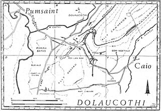
located in the valley of the River Cothi
, near Pumsaint
, Carmarthenshire
, Wales
. The gold mines are located within the Dolaucothi Estate
which is now owned by the National Trust.
They are the only mines for Welsh gold
outside those of the Dolgellau
gold-belt, and are a Scheduled Ancient Monument
. They are also the only known Roman gold mines in Britain
, although it does not exclude the likelihood that they exploited other known sources in Devon
, North Wales
and Scotland
for example. The site is important for showing advanced Roman technology
.
suggests that gold
extraction on this site may have started sometime in the Bronze Age
, possibly by washing of the gold-bearing gravels of the river Cothi, the most elementary type of gold prospecting
. Sextus Julius Frontinus
was sent into Roman Britain
in 74 AD to succeed Quintus Petillius Cerialis
as governor of that island. He subdued the Silures
, Demetae
and other hostile tribes of Roman Wales, establishing a new base at Caerleon
for Legio II Augusta
and a network of smaller Roman forts fifteen to twenty kilometres apart for his Roman auxiliary units. During his tenure, he probably established the fort at Pumsaint
in west Wales, largely to exploit the gold
deposits at Dolaucothi. Frontinus later restored the Aqueducts of Rome
.
That gold occurred here is shown by the discovery of a hoard
of gold ornaments in the 18th century. Objects found included a wheel brooch and snake bracelets, so named because they were soft enough to be coiled around the arm for display. All the objects are now held in the British Museum
, and displayed in the Romano-British gallery. A sample of gold ore was found at the site by Henry de la Beche
in 1844, confirming the presence of gold.
 Evidence from the fortification
(known as Luentinum
from details given by Ptolemy
) and its associated settlement
show that the Roman army occupied the fort during the 1st and 2nd centuries AD (from circa AD 78 until around AD 125). However, coarse ware and Samian ware pottery recovered from a reservoir (Melin-y-Milwyr) within the mine complex show that activity at the mines continued until the late 3rd century at least. Since Ptolemy's map dates to about 150 AD, it is likely that it continued being worked until the end of the 3rd century if not beyond. The Romans made extensive use of water carried by several aqueduct
s and leat
s, the longest of which is about 7 miles from its source in a gorge of the river, to prospect for the gold veins hidden beneath the soil on the hillsides above the modern village of Pumsaint
. Small streams on Mynydd Mallaen, the Annell and Gwenlais, were used initially to provide water for prospecting, and there are several large tanks for holding the water still visible above an isolated opencast pit carved in the side of the hill north of the main site. The larger aqueduct from the Cothi crosses this opencast, proving the opencast to be earlier.
 The water was stored in the tanks and then released suddenly, the wave of water sweeping away the soil to reveal the bedrock and any gold-bearing veins beneath. Pliny the Elder
gives a dramatic account in his Naturalis Historia
of the method, possibly derived from his experiences in Spain. The method is known as hushing
and survived in use until the 19th century in Britain, and into the 20th century in the goldfield
s of Africa
. A not dissimilar method is used today in exploiting alluvial tin
deposits, and is known as hydraulic mining
. A smaller scale version of the same method is placer mining
, and both may have been used to work alluvial placer deposit
s next to the river Cothi itself, judging by a large aqueduct which tapped the river a mile or so upstream, and enters the site at a low level compared with the other known aqueducts on the site. The water supply of the aqueducts was also used for washing crushed gold ore, and also possibly driving stamping mills for comminution
of the ore (Lewis and Jones, 1969). One of the first aqueduct
s was built at a high level on the east slope of Allt Cwmhenog and tapped a small stream about two miles away. There is a large tank at its end, where it sweeps around the brow of the hill onto the west side of the ridge. A gold vein must have been discovered here, because there is a large opencast below the tank. Yet the larger and longer aqueduct (with a gradient of 1 in 800) taps the river Cothi
about 7 miles to the north-east and traverses the same opencast, so must be later in date.
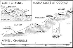
By contrast, several tanks found on the site did not show a vein, so were abandoned. The tank shown at right occurs not far from the north opencast and was probably intended to find the limits of the deposit located in the adjacent opencast (Tank A in the schematic diagram below). It clearly didn't find the vein, and was thus abandoned. The water supply may have been obtained from a small leat
run from a stream up the main Cothi valley before the much larger aqueduct was constructed.
 Prospecting was successful and several opencasts are visible below the large tanks built along its length. The only exception is the final and very large tank, below which are two reservoirs. It is likely that this complex was used for washing powdered ore to collect the gold dust.
  More leat
s and tanks can be found below the line of the main aqueduct, some of which are shown on the map of the site. They surround the lip of the very large opencast and the tank shown at right is one which was built on the main aqueduct. It was successful in finding a vein, judging by the opencast below, but must have been modified later to feed a washing table built to the left-hand side (near the figure in the picture), probably to wash the crushed ore from the same opencast working. It is labelled Tank C in the schematic diagram. Similar tanks occur below as the Romans followed the large vein down to the road and the main opencast. Most of the opencast workings must therefore be Roman in origin, since one of the aqueducts has been confirmed by carbon 14 dating as to predate all modern workings. Just by the road itself the Carreg Pumsaint has been erected in the space beside a large mound, now thought to be a dump of waste material from mining activities.
The existing ponds above and below the minor road from Pumsaint
to Caeo, were probably part of a cascade for washing ore, the upper tank having yielded large quantities of Roman pottery from ca 78 to at least 300 AD (Lewis, 1977; Burnham 2004). The upper pool is known as Melin-y-Milwyr, or the soldier's mill, an intriguing name that implies that watermills may have been used here during the Roman period. Alternatively, it may have been a sequence of washing tables for the crushed gold ore. A large-scale mill complex is known from Barbegal in southern France
, where no less than 16 mills (in two lines of 8 each) were built into the side of a hill and supplied with water from a single aqueduct. There were two lines of parallel overshot mills, the outflow from one feeding the next below. The mill supplied flour to the region. Moreover, Roman engineers used sequences of reverse overshot water-wheel
s to dewater mines, and the deep workings at Dolaucothi produced a fragment of such a wheel during the 1930s when deep mining operations were resumed. Sequences of such wheels increased the lift, and one extensive sequence of 16 wheels was found in old Roman mine workings on the Rio Tinto river in the 1920s. The wheels were arranged in pairs and could lift water about 80 feet from the bottom of the mine there.
 The tank at the head of the small road from Pumsaint to Caio was thought to be modern since it still holds water. However, when the level of the water was low in 1970, it yielded large quantities of Roman pottery which show that it is of Roman origin and built early during their exploitation of the mines. The section shows that it was connected to a smaller tank just below the modern road by a drystone culvert in a cascade. The lower tank also holds water but is in an advanced state of eutrophication
. The collection of fragments included Samian ware and coarse ware from over 100 separate pots, and must have fallen into the reservoir when the mines were in full operation. Analysis of the pottery fragments showed a distribution of ages from the late 1st century AD through to the end of the 4th century. Since the fort and fortlet under the present village of Pumsaint ends in the middle of the 2nd century, it shows that mining continued for a long time after the military evacuation.
 It implies that there is a large mining settlement in the vicinity of the village of Pumsaint which has yet to be found.
The exact function of the cascade is related to the methods of extracting the final traces of gold from the crushed ore. There were probably washing tables between the two tanks so that a gentle stream of water could be used to wash the ore on the rough surface of the tables, the finer gold being caught in the rougher parts of the tables, and removed at the end of the process. The cascade would probably have been built towards the end of the 1st century when underground mining commenced following opencast development.
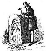 This site yields some of the earliest evidence anywhere for the Roman use of water-powered trip-hammers to crush ore (Burnham 1997). The ore was probably crushed on the famous Carreg Pumsaint, a block of stone erected many years ago after the Romans had left the site. There are parallels with similar stones at other ancient Roman mines in Europe, and the hollows in the block were formed by a trip hammer probably worked by a water wheel
or a "water lever". Such a water-powered hammer would have been moved regularly as each hollow became too deep, so producing the series of overlapping oval hollows in its surfaces. The hammer head must have been of substantial size judging by the width of the hollows shown in the drawing. The stone is the only example so far discovered at the site, but is not unique, and Burnham refers to others of similar shape from Spain. As one side of the stone became worn, it was simply turned to reveal another side, so the block could be re-used several times. When found years after the Romans had left, in the Dark Ages, it gave rise to the legend of the five saints, who left the impression of their heads in the stone after being found asleep by the devil.
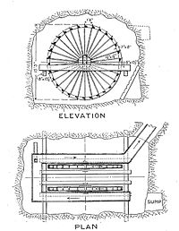
 At Dolaucothi, a similar discovery was made in 1935 during mining operations, and it included part of a reverse overshot water-wheel
which is now in the National Museum of Wales. It was found with burnt timbers, suggesting that fire-setting
was used to help break up the hard quartz in which the gold was trapped. A similar but larger wheel was rediscovered during mine operations at Rio Tinto in Spain
, and is now in the British Museum
, where it is displayed prominently in the Roman gallery. The Spanish example included a sequence of no fewer than 16 reverse overshot water-wheel
s, each pair of wheels feeding water to the next set in the sequence. Each wheel would have been worked like a treadwheel
, from the side rather than at the top, but it would have been a hard and lonely activity for the miners working these wheels lifting water from the mine bottom. Since the fragment of a reverse overshot water-wheel
was found 160 feet below any known adit
or stope, it must have been part of a similar sequence at Dolaucothi to that in Spain. Gold mining
was sophisticated and technologically advanced at Dolaucothi, suggesting that the Roman army
itself pioneered exploitation at the site. The construction of such dewatering machines is described by the Roman engineer Vitruvius
writing in 25 BC, and their use for irrigation
and lifting water in thermae
was widespread.
At another part of the mine, on Pen-lan-wen, water would have been in short supply; a siphon could have transferred water from the main aqueduct or one of its tanks, but remains unproven. The vein carries along the hill for some considerable distance, and has been trenched out. This method involved excavating the vein vertically down while keeping the top open. However, ventilation becomes a problem when fire-setting is used, so three long adits were driven in from the hillside to the north. They are much wider than normal galleries, suggesting that their primary purpose was to allow circulation of air through the trench and permit safe fire-setting
. The upper two adit
s are still open to the trench, but the lowest one is currently blocked.
 Although there is nothing directly comparable with Dolaucothi in Britain in terms of the extensive hydraulic systems, there are many other known Roman mines in Britain, some of which seem to show traces of hydraulic activity. They include the extensive remains of lead
mining at Charterhouse
in the Mendips
, Halkyn
in Flintshire
, and many areas in the Pennines
. Dolaucothi is most directly comparable with gold mines in the Carpathian mountains
of Transylvania
in modern Romania
, at Rosia Montana
, and with the Roman gold mines in north-west Spain
, such as the very much larger site of alluvial mining at Las Medulas
and Montefurado. The Romans may have used slave labour taken from the local area to work the mine, although the army itself was probably most directly involved, especially for their engineering skills in surveying and building aqueducts, reservoirs and water tanks or cistern
s.
 There is some evidence that some of the gold
was worked at the site, judging by the finished brooch shown above, as well as other finished gold products.
A part engraved jewel
has also been found in the vicinity. Such activities would have needed skilled, not slave labour. No workshops or furnaces have yet been found, but it is likely that both existed on site. Ingots of gold would have been easier to transport than dust or nuggets, although a high-temperature refractory
furnace
will have been needed to melt the gold, which has a melting point
of 1064 °C. Pliny mentions such special furnaces in his Naturalis Historia
. A workshop
will have been vital for building and maintaining mining equipment such as the drainage wheels, flume
s for washing tables, shuttering for aqueducts, crushing equipment and pit-props. Official mints would have produced gold coin
s, a key component of Roman currency
. After the military occupation the mine may have been taken over by Romano-British
civilian contractors some time after 125 AD, although the final history of the site has yet to be determined.
Between 1975 and 2000 the lease to the underground workings at Dolaucothi was held by Cardiff University. Students from the School of Engineering were largely responsible for the renovation of the underground workings that were made safe for tourists. The mine was extensively used as a training mine for Mining Engineering and Exploration Geology students under the supervision of Drs. Alun Issac, Alwyn Annels and Peter Brabham. Students from the School of Earth Sciences carried out an active gold exploration programme using surface and underground diamond drilling techniques, geochemical soil sampling and geophysics.Geological exploration was carried out by students using both surface and underground drilling methods. The ore processing waste tailings dam was also sampled, mapped geophysically and assessed for its Gold potential. The mine was extensively mapped and a library of Dolaucothi data is still held at the School of Earth & Ocean Sciences at Cardiff University. Cardiff University finally gave up the lease to the underground workings in 2000 due to the closure of its BSc Mining Engineering degree course. Photographs of surface and underground activities from the Cardiff University archives can be found from the links below.
Although there is yet no comparable site in Britain, it is likely that field work will locate other mines, simply by tracing the remains of aqueducts and reservoirs, and often, if not usually, aided by aerial photography
. Physical remains like tanks and aqueducts are often recognised by the shadows cast by the structures in oblique lighting conditions. Thus Tank A was first seen in early morning light when the sun's rays cast an oblique light across the hill (Allt Cwmhenog) on which the structure is situated.
mines of Nantymwyn near Rhandirymwyn village some 8 miles away to the north may also have been first worked by the Romans, judging by hushing
tanks and aqueducts found there in the 1970s both from fieldwork and aerial photographs. They occur at the top of the mountain called Pen-cerrig-mwyn, and the veins were followed underground by several tunnels leading to the workings. Inside, the veins have been removed and debris carefully stacked within the stope. The workings lie far above the later modern mines and processing plant (now derelict). The later mine was once the largest lead mine in Wales.
and Bremia (fort) near Llanio, and as of 2003, in Llandeilo
.
's National Trust
has owned and run the Dolaucothi gold mine and Dolaucothi Estate
since 1941 when it was bequeathed by descendants of the Johnes family who had owned the mine and large surrounding estate since the late 16th century. Manchester and Cardiff Universities were active in exploring the extensive remains in the 1960s and 70s and Lampeter University is now closely involved with the archaeology
of the site. The National Trust organises guided tours for visitors, showing them the mine and the Roman archaeology.
Ancient Rome
Ancient Rome was a thriving civilization that grew on the Italian Peninsula as early as the 8th century BC. Located along the Mediterranean Sea and centered on the city of Rome, it expanded to one of the largest empires in the ancient world....
surface and deep mines
Mining
Mining is the extraction of valuable minerals or other geological materials from the earth, from an ore body, vein or seam. The term also includes the removal of soil. Materials recovered by mining include base metals, precious metals, iron, uranium, coal, diamonds, limestone, oil shale, rock...
located in the valley of the River Cothi
River Cothi
The River Cothi is the largest tributary of the River Tywi in south Wales. It is noted for its trout and sea trout fishing and for its beautiful scenery.-Dolaucothi:...
, near Pumsaint
Pumsaint
Pumsaint is a village in Carmarthenshire, Wales situated half way between Llanwrda and Lampeter on the A482 in the valley of the River Cothi. It forms part of the extensive estate of Dolaucothi which is owned by the National Trust....
, Carmarthenshire
Carmarthenshire
Carmarthenshire is a unitary authority in the south west of Wales and one of thirteen historic counties. It is the 3rd largest in Wales. Its three largest towns are Llanelli, Carmarthen and Ammanford...
, Wales
Wales
Wales is a country that is part of the United Kingdom and the island of Great Britain, bordered by England to its east and the Atlantic Ocean and Irish Sea to its west. It has a population of three million, and a total area of 20,779 km²...
. The gold mines are located within the Dolaucothi Estate
Dolaucothi Estate
The Dolaucothi Estate, or as it was often later spelt, Dolaucothy Estate is situated about one mile north-west of the village of Caio in the upper reaches of the picturesque Cothi valley in the parish of Cynwyl Gaeo, Carmarthenshire...
which is now owned by the National Trust.
They are the only mines for Welsh gold
Welsh gold
Welsh gold is highly prized because of its origin and scarcity, and occurs naturally in two distinct areas of Wales. One area is in North Wales in a band stretching from Barmouth, past Dolgellau and up towards Snowdonia. This was mined at several mines, the largest of which were the Gwynfynydd Gold...
outside those of the Dolgellau
Dolgellau
Dolgellau is a market town in Gwynedd, north-west Wales, lying on the River Wnion, a tributary of the River Mawddach. It was the county town of the former county of Merionethshire .-History and economy:...
gold-belt, and are a Scheduled Ancient Monument
Scheduled Ancient Monument
In the United Kingdom, a scheduled monument is a 'nationally important' archaeological site or historic building, given protection against unauthorized change. The various pieces of legislation used for legally protecting heritage assets from damage and destruction are grouped under the term...
. They are also the only known Roman gold mines in Britain
Mining in Roman Britain
Mining was one of the most prosperous activities in Roman Britain. Britain was rich in resources such as copper, gold, iron, lead, salt, silver, and tin, materials in high demand in the Roman Empire. The abundance of mineral resources in the British Isles was probably one of the reasons for the...
, although it does not exclude the likelihood that they exploited other known sources in Devon
Devon
Devon is a large county in southwestern England. The county is sometimes referred to as Devonshire, although the term is rarely used inside the county itself as the county has never been officially "shired", it often indicates a traditional or historical context.The county shares borders with...
, North Wales
North Wales
North Wales is the northernmost unofficial region of Wales. It is bordered to the south by the counties of Ceredigion and Powys in Mid Wales and to the east by the counties of Shropshire in the West Midlands and Cheshire in North West England...
and Scotland
Scotland
Scotland is a country that is part of the United Kingdom. Occupying the northern third of the island of Great Britain, it shares a border with England to the south and is bounded by the North Sea to the east, the Atlantic Ocean to the north and west, and the North Channel and Irish Sea to the...
for example. The site is important for showing advanced Roman technology
Roman technology
Roman technology is the engineering practice which supported Roman civilization and made the expansion of Roman commerce and Roman military possible over nearly a thousand years....
.
Roman mining methods
ArchaeologyArchaeology
Archaeology, or archeology , is the study of human society, primarily through the recovery and analysis of the material culture and environmental data that they have left behind, which includes artifacts, architecture, biofacts and cultural landscapes...
suggests that gold
Gold
Gold is a chemical element with the symbol Au and an atomic number of 79. Gold is a dense, soft, shiny, malleable and ductile metal. Pure gold has a bright yellow color and luster traditionally considered attractive, which it maintains without oxidizing in air or water. Chemically, gold is a...
extraction on this site may have started sometime in the Bronze Age
Bronze Age
The Bronze Age is a period characterized by the use of copper and its alloy bronze as the chief hard materials in the manufacture of some implements and weapons. Chronologically, it stands between the Stone Age and Iron Age...
, possibly by washing of the gold-bearing gravels of the river Cothi, the most elementary type of gold prospecting
Gold prospecting
Gold prospecting is the act of searching for new gold deposits. Methods used vary with the type of deposit sought and the resources of the prospector...
. Sextus Julius Frontinus
Sextus Julius Frontinus
Sextus Julius Frontinus was one of the most distinguished Roman aristocrats of the late 1st century AD, but is best known to the post-Classical world as an author of technical treatises, especially one dealing with the aqueducts of Rome....
was sent into Roman Britain
Roman Britain
Roman Britain was the part of the island of Great Britain controlled by the Roman Empire from AD 43 until ca. AD 410.The Romans referred to the imperial province as Britannia, which eventually comprised all of the island of Great Britain south of the fluid frontier with Caledonia...
in 74 AD to succeed Quintus Petillius Cerialis
Quintus Petillius Cerialis
Quintus Petilius Cerialis Caesius Rufus was a Roman general and administrator who served in Britain during Boudica's rebellion and who went on to participate in the civil wars after the death of Nero. He later defeated the rebellion of Julius Civilis and returned to Britain as its governor.His...
as governor of that island. He subdued the Silures
Silures
The Silures were a powerful and warlike tribe of ancient Britain, occupying approximately the counties of Monmouthshire, Breconshire and Glamorganshire of present day South Wales; and possibly Gloucestershire and Herefordshire of present day England...
, Demetae
Demetae
The Demetae were a Celtic people of Iron Age Britain who inhabited modern Pembrokeshire and Carmarthenshire in south-west Wales, and gave their name to the county of Dyfed.-Classical mention:...
and other hostile tribes of Roman Wales, establishing a new base at Caerleon
Caerleon
Caerleon is a suburban village and community, situated on the River Usk in the northern outskirts of the city of Newport, South Wales. Caerleon is a site of archaeological importance, being the site of a notable Roman legionary fortress, Isca Augusta, and an Iron Age hill fort...
for Legio II Augusta
Legio II Augusta
Legio secunda Augusta , was a Roman legion, levied by Gaius Vibius Pansa Caetronianus in 43 BC, and still operative in Britannia in the 4th century...
and a network of smaller Roman forts fifteen to twenty kilometres apart for his Roman auxiliary units. During his tenure, he probably established the fort at Pumsaint
Pumsaint
Pumsaint is a village in Carmarthenshire, Wales situated half way between Llanwrda and Lampeter on the A482 in the valley of the River Cothi. It forms part of the extensive estate of Dolaucothi which is owned by the National Trust....
in west Wales, largely to exploit the gold
Gold
Gold is a chemical element with the symbol Au and an atomic number of 79. Gold is a dense, soft, shiny, malleable and ductile metal. Pure gold has a bright yellow color and luster traditionally considered attractive, which it maintains without oxidizing in air or water. Chemically, gold is a...
deposits at Dolaucothi. Frontinus later restored the Aqueducts of Rome
Aqueducts of Rome
This is a list of aqueducts in Rome listed in chronological order of their construction.- Ancient Rome :* Aqua Appia** built in 312 BC** source: springs to the east of Rome...
.
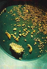
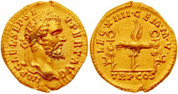
That gold occurred here is shown by the discovery of a hoard
Hoard
In archaeology, a hoard is a collection of valuable objects or artifacts, sometimes purposely buried in the ground. This would usually be with the intention of later recovery by the hoarder; hoarders sometimes died before retrieving the hoard, and these surviving hoards may be uncovered by...
of gold ornaments in the 18th century. Objects found included a wheel brooch and snake bracelets, so named because they were soft enough to be coiled around the arm for display. All the objects are now held in the British Museum
British Museum
The British Museum is a museum of human history and culture in London. Its collections, which number more than seven million objects, are amongst the largest and most comprehensive in the world and originate from all continents, illustrating and documenting the story of human culture from its...
, and displayed in the Romano-British gallery. A sample of gold ore was found at the site by Henry de la Beche
Henry De la Beche
Sir Henry Thomas De la Beche FRS was an English geologist and palaeontologist who helped pioneer early geological survey methods.-Biography:...
in 1844, confirming the presence of gold.
Fortification
Fortifications are military constructions and buildings designed for defence in warfare and military bases. Humans have constructed defensive works for many thousands of years, in a variety of increasingly complex designs...
(known as Luentinum
Luentinum
Luentinum was a fort and mining settlement in the Roman province of Britannia. It was associated with the Dolaucothi Gold Mines and its remains lie beneath the adjoining village of Pumsaint in the Welsh county of Carmarthenshire. It lay between similar forts at Llandovery and Bremia near Llanio,...
from details given by Ptolemy
Ptolemy
Claudius Ptolemy , was a Roman citizen of Egypt who wrote in Greek. He was a mathematician, astronomer, geographer, astrologer, and poet of a single epigram in the Greek Anthology. He lived in Egypt under Roman rule, and is believed to have been born in the town of Ptolemais Hermiou in the...
) and its associated settlement
Vicus (Rome)
In ancient Rome, the vicus was a neighborhood. During the Republican era, the four regiones of the city of Rome were subdivided into vici. In the 1st century BC, Augustus reorganized the city for administrative purposes into 14 regions, comprising 265 vici. Each vicus had its own board of...
show that the Roman army occupied the fort during the 1st and 2nd centuries AD (from circa AD 78 until around AD 125). However, coarse ware and Samian ware pottery recovered from a reservoir (Melin-y-Milwyr) within the mine complex show that activity at the mines continued until the late 3rd century at least. Since Ptolemy's map dates to about 150 AD, it is likely that it continued being worked until the end of the 3rd century if not beyond. The Romans made extensive use of water carried by several aqueduct
Aqueduct
An aqueduct is a water supply or navigable channel constructed to convey water. In modern engineering, the term is used for any system of pipes, ditches, canals, tunnels, and other structures used for this purpose....
s and leat
Leat
A leat is the name, common in the south and west of England and in Wales, for an artificial watercourse or aqueduct dug into the ground, especially one supplying water to a watermill or its mill pond...
s, the longest of which is about 7 miles from its source in a gorge of the river, to prospect for the gold veins hidden beneath the soil on the hillsides above the modern village of Pumsaint
Pumsaint
Pumsaint is a village in Carmarthenshire, Wales situated half way between Llanwrda and Lampeter on the A482 in the valley of the River Cothi. It forms part of the extensive estate of Dolaucothi which is owned by the National Trust....
. Small streams on Mynydd Mallaen, the Annell and Gwenlais, were used initially to provide water for prospecting, and there are several large tanks for holding the water still visible above an isolated opencast pit carved in the side of the hill north of the main site. The larger aqueduct from the Cothi crosses this opencast, proving the opencast to be earlier.
Hydraulic mining
Pliny the Elder
Gaius Plinius Secundus , better known as Pliny the Elder, was a Roman author, naturalist, and natural philosopher, as well as naval and army commander of the early Roman Empire, and personal friend of the emperor Vespasian...
gives a dramatic account in his Naturalis Historia
Naturalis Historia
The Natural History is an encyclopedia published circa AD 77–79 by Pliny the Elder. It is one of the largest single works to have survived from the Roman Empire to the modern day and purports to cover the entire field of ancient knowledge, based on the best authorities available to Pliny...
of the method, possibly derived from his experiences in Spain. The method is known as hushing
Hushing
Hushing is an ancient and historic mining method using a flood or torrent of water to reveal mineral veins. The method was applied in several ways, both in prospecting for ores, and for their exploitation. Mineral veins are often hidden below soil and sub-soil, which must be stripped away to...
and survived in use until the 19th century in Britain, and into the 20th century in the goldfield
Gold mining
Gold mining is the removal of gold from the ground. There are several techniques and processes by which gold may be extracted from the earth.-History:...
s of Africa
Africa
Africa is the world's second largest and second most populous continent, after Asia. At about 30.2 million km² including adjacent islands, it covers 6% of the Earth's total surface area and 20.4% of the total land area...
. A not dissimilar method is used today in exploiting alluvial tin
Tin
Tin is a chemical element with the symbol Sn and atomic number 50. It is a main group metal in group 14 of the periodic table. Tin shows chemical similarity to both neighboring group 14 elements, germanium and lead and has two possible oxidation states, +2 and the slightly more stable +4...
deposits, and is known as hydraulic mining
Hydraulic mining
Hydraulic mining, or hydraulicking, is a form of mining that uses high-pressure jets of water to dislodge rock material or move sediment. In the placer mining of gold or tin, the resulting water-sediment slurry is directed through sluice boxes to remove the gold.-Precursor - ground...
. A smaller scale version of the same method is placer mining
Placer mining
Placer mining is the mining of alluvial deposits for minerals. This may be done by open-pit or by various surface excavating equipment or tunneling equipment....
, and both may have been used to work alluvial placer deposit
Placer deposit
In geology, a placer deposit or placer is an accumulation of valuable minerals formed by gravity separation during sedimentary processes. The name is from the Spanish word placer, meaning "alluvial sand". Placer mining is an important source of gold, and was the main technique used in the early...
s next to the river Cothi itself, judging by a large aqueduct which tapped the river a mile or so upstream, and enters the site at a low level compared with the other known aqueducts on the site. The water supply of the aqueducts was also used for washing crushed gold ore, and also possibly driving stamping mills for comminution
Comminution
Comminution is the process in which solid materials are reduced in size, by crushing, grinding and other processes. It occurs naturally during faulting in the upper part of the crust and is an important operation in mineral processing, ceramics, electronics and other fields. Within industrial uses,...
of the ore (Lewis and Jones, 1969).
Aqueduct
An aqueduct is a water supply or navigable channel constructed to convey water. In modern engineering, the term is used for any system of pipes, ditches, canals, tunnels, and other structures used for this purpose....
s was built at a high level on the east slope of Allt Cwmhenog and tapped a small stream about two miles away. There is a large tank at its end, where it sweeps around the brow of the hill onto the west side of the ridge. A gold vein must have been discovered here, because there is a large opencast below the tank. Yet the larger and longer aqueduct (with a gradient of 1 in 800) taps the river Cothi
River Cothi
The River Cothi is the largest tributary of the River Tywi in south Wales. It is noted for its trout and sea trout fishing and for its beautiful scenery.-Dolaucothi:...
about 7 miles to the north-east and traverses the same opencast, so must be later in date.
By contrast, several tanks found on the site did not show a vein, so were abandoned. The tank shown at right occurs not far from the north opencast and was probably intended to find the limits of the deposit located in the adjacent opencast (Tank A in the schematic diagram below). It clearly didn't find the vein, and was thus abandoned. The water supply may have been obtained from a small leat
Leat
A leat is the name, common in the south and west of England and in Wales, for an artificial watercourse or aqueduct dug into the ground, especially one supplying water to a watermill or its mill pond...
run from a stream up the main Cothi valley before the much larger aqueduct was constructed.
Opencast mining
Leat
A leat is the name, common in the south and west of England and in Wales, for an artificial watercourse or aqueduct dug into the ground, especially one supplying water to a watermill or its mill pond...
s and tanks can be found below the line of the main aqueduct, some of which are shown on the map of the site. They surround the lip of the very large opencast and the tank shown at right is one which was built on the main aqueduct. It was successful in finding a vein, judging by the opencast below, but must have been modified later to feed a washing table built to the left-hand side (near the figure in the picture), probably to wash the crushed ore from the same opencast working. It is labelled Tank C in the schematic diagram. Similar tanks occur below as the Romans followed the large vein down to the road and the main opencast. Most of the opencast workings must therefore be Roman in origin, since one of the aqueducts has been confirmed by carbon 14 dating as to predate all modern workings. Just by the road itself the Carreg Pumsaint has been erected in the space beside a large mound, now thought to be a dump of waste material from mining activities.
The existing ponds above and below the minor road from Pumsaint
Pumsaint
Pumsaint is a village in Carmarthenshire, Wales situated half way between Llanwrda and Lampeter on the A482 in the valley of the River Cothi. It forms part of the extensive estate of Dolaucothi which is owned by the National Trust....
to Caeo, were probably part of a cascade for washing ore, the upper tank having yielded large quantities of Roman pottery from ca 78 to at least 300 AD (Lewis, 1977; Burnham 2004). The upper pool is known as Melin-y-Milwyr, or the soldier's mill, an intriguing name that implies that watermills may have been used here during the Roman period. Alternatively, it may have been a sequence of washing tables for the crushed gold ore. A large-scale mill complex is known from Barbegal in southern France
France
The French Republic , The French Republic , The French Republic , (commonly known as France , is a unitary semi-presidential republic in Western Europe with several overseas territories and islands located on other continents and in the Indian, Pacific, and Atlantic oceans. Metropolitan France...
, where no less than 16 mills (in two lines of 8 each) were built into the side of a hill and supplied with water from a single aqueduct. There were two lines of parallel overshot mills, the outflow from one feeding the next below. The mill supplied flour to the region. Moreover, Roman engineers used sequences of reverse overshot water-wheel
Reverse overshot water-wheel
Frequently used in mines and probably elsewhere , the reverse overshot water wheel was a Roman innovation to help remove water from the lowest levels of underground workings. It is described by Vitruvius in his work De Architectura published circa 25 BC...
s to dewater mines, and the deep workings at Dolaucothi produced a fragment of such a wheel during the 1930s when deep mining operations were resumed. Sequences of such wheels increased the lift, and one extensive sequence of 16 wheels was found in old Roman mine workings on the Rio Tinto river in the 1920s. The wheels were arranged in pairs and could lift water about 80 feet from the bottom of the mine there.
Melin-y-Milwyr
Eutrophication
Eutrophication or more precisely hypertrophication, is the movement of a body of water′s trophic status in the direction of increasing plant biomass, by the addition of artificial or natural substances, such as nitrates and phosphates, through fertilizers or sewage, to an aquatic system...
. The collection of fragments included Samian ware and coarse ware from over 100 separate pots, and must have fallen into the reservoir when the mines were in full operation. Analysis of the pottery fragments showed a distribution of ages from the late 1st century AD through to the end of the 4th century. Since the fort and fortlet under the present village of Pumsaint ends in the middle of the 2nd century, it shows that mining continued for a long time after the military evacuation.
The exact function of the cascade is related to the methods of extracting the final traces of gold from the crushed ore. There were probably washing tables between the two tanks so that a gentle stream of water could be used to wash the ore on the rough surface of the tables, the finer gold being caught in the rougher parts of the tables, and removed at the end of the process. The cascade would probably have been built towards the end of the 1st century when underground mining commenced following opencast development.
Carreg Pumsaint
Water wheel
A water wheel is a machine for converting the energy of free-flowing or falling water into useful forms of power. A water wheel consists of a large wooden or metal wheel, with a number of blades or buckets arranged on the outside rim forming the driving surface...
or a "water lever". Such a water-powered hammer would have been moved regularly as each hollow became too deep, so producing the series of overlapping oval hollows in its surfaces. The hammer head must have been of substantial size judging by the width of the hollows shown in the drawing. The stone is the only example so far discovered at the site, but is not unique, and Burnham refers to others of similar shape from Spain. As one side of the stone became worn, it was simply turned to reveal another side, so the block could be re-used several times. When found years after the Romans had left, in the Dark Ages, it gave rise to the legend of the five saints, who left the impression of their heads in the stone after being found asleep by the devil.
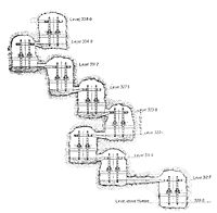
Deep mining
They followed the veins with shafts and tunnels underground, some of which still exist on the site. The remains of Roman dewatering machines were found during the 1880s and the 1920s when the Rio Tinto mines in Spain were being mined by opencast methods.Reverse overshot water-wheel
Frequently used in mines and probably elsewhere , the reverse overshot water wheel was a Roman innovation to help remove water from the lowest levels of underground workings. It is described by Vitruvius in his work De Architectura published circa 25 BC...
which is now in the National Museum of Wales. It was found with burnt timbers, suggesting that fire-setting
Fire-setting
Fire-setting is a method of mining used since prehistoric times up to the Middle Ages. Fires were set against a rock face to heat the stone, which was then doused with water...
was used to help break up the hard quartz in which the gold was trapped. A similar but larger wheel was rediscovered during mine operations at Rio Tinto in Spain
Spain
Spain , officially the Kingdom of Spain languages]] under the European Charter for Regional or Minority Languages. In each of these, Spain's official name is as follows:;;;;;;), is a country and member state of the European Union located in southwestern Europe on the Iberian Peninsula...
, and is now in the British Museum
British Museum
The British Museum is a museum of human history and culture in London. Its collections, which number more than seven million objects, are amongst the largest and most comprehensive in the world and originate from all continents, illustrating and documenting the story of human culture from its...
, where it is displayed prominently in the Roman gallery. The Spanish example included a sequence of no fewer than 16 reverse overshot water-wheel
Reverse overshot water-wheel
Frequently used in mines and probably elsewhere , the reverse overshot water wheel was a Roman innovation to help remove water from the lowest levels of underground workings. It is described by Vitruvius in his work De Architectura published circa 25 BC...
s, each pair of wheels feeding water to the next set in the sequence. Each wheel would have been worked like a treadwheel
Treadwheel
A treadwheel is a form of animal engine typically powered by humans. It may resemble a water wheel in appearance, and can be worked either by a human treading paddles set into its circumference , or by a human or animal standing inside it .Uses of treadwheels included raising water, to power...
, from the side rather than at the top, but it would have been a hard and lonely activity for the miners working these wheels lifting water from the mine bottom. Since the fragment of a reverse overshot water-wheel
Reverse overshot water-wheel
Frequently used in mines and probably elsewhere , the reverse overshot water wheel was a Roman innovation to help remove water from the lowest levels of underground workings. It is described by Vitruvius in his work De Architectura published circa 25 BC...
was found 160 feet below any known adit
Adit
An adit is an entrance to an underground mine which is horizontal or nearly horizontal, by which the mine can be entered, drained of water, and ventilated.-Construction:...
or stope, it must have been part of a similar sequence at Dolaucothi to that in Spain. Gold mining
Gold mining
Gold mining is the removal of gold from the ground. There are several techniques and processes by which gold may be extracted from the earth.-History:...
was sophisticated and technologically advanced at Dolaucothi, suggesting that the Roman army
Roman army
The Roman army is the generic term for the terrestrial armed forces deployed by the kingdom of Rome , the Roman Republic , the Roman Empire and its successor, the Byzantine empire...
itself pioneered exploitation at the site. The construction of such dewatering machines is described by the Roman engineer Vitruvius
Vitruvius
Marcus Vitruvius Pollio was a Roman writer, architect and engineer, active in the 1st century BC. He is best known as the author of the multi-volume work De Architectura ....
writing in 25 BC, and their use for irrigation
Irrigation
Irrigation may be defined as the science of artificial application of water to the land or soil. It is used to assist in the growing of agricultural crops, maintenance of landscapes, and revegetation of disturbed soils in dry areas and during periods of inadequate rainfall...
and lifting water in thermae
Thermae
In ancient Rome, thermae and balnea were facilities for bathing...
was widespread.
At another part of the mine, on Pen-lan-wen, water would have been in short supply; a siphon could have transferred water from the main aqueduct or one of its tanks, but remains unproven. The vein carries along the hill for some considerable distance, and has been trenched out. This method involved excavating the vein vertically down while keeping the top open. However, ventilation becomes a problem when fire-setting is used, so three long adits were driven in from the hillside to the north. They are much wider than normal galleries, suggesting that their primary purpose was to allow circulation of air through the trench and permit safe fire-setting
Fire-setting
Fire-setting is a method of mining used since prehistoric times up to the Middle Ages. Fires were set against a rock face to heat the stone, which was then doused with water...
. The upper two adit
Adit
An adit is an entrance to an underground mine which is horizontal or nearly horizontal, by which the mine can be entered, drained of water, and ventilated.-Construction:...
s are still open to the trench, but the lowest one is currently blocked.
Similar sites
Lead
Lead is a main-group element in the carbon group with the symbol Pb and atomic number 82. Lead is a soft, malleable poor metal. It is also counted as one of the heavy metals. Metallic lead has a bluish-white color after being freshly cut, but it soon tarnishes to a dull grayish color when exposed...
mining at Charterhouse
Charterhouse, Somerset
Charterhouse, also known as Charterhouse-on-Mendip, is a hamlet in the Mendip Hills Area of Outstanding Natural Beauty in the English county of Somerset...
in the Mendips
Mendip Hills
The Mendip Hills is a range of limestone hills to the south of Bristol and Bath in Somerset, England. Running east to west between Weston-super-Mare and Frome, the hills overlook the Somerset Levels to the south and the Avon Valley to the north...
, Halkyn
Halkyn
Halkyn is a village in Flintshire, north-east Wales and situated between Pentre Halkyn, Northop and Rhosesmor. At the 2001 Census the population of the community was 2,876.- History :...
in Flintshire
Flintshire
Flintshire is a county in north-east Wales. It borders Denbighshire, Wrexham and the English county of Cheshire. It is named after the historic county of Flintshire, which had notably different borders...
, and many areas in the Pennines
Pennines
The Pennines are a low-rising mountain range, separating the North West of England from Yorkshire and the North East.Often described as the "backbone of England", they form a more-or-less continuous range stretching from the Peak District in Derbyshire, around the northern and eastern edges of...
. Dolaucothi is most directly comparable with gold mines in the Carpathian mountains
Carpathian Mountains
The Carpathian Mountains or Carpathians are a range of mountains forming an arc roughly long across Central and Eastern Europe, making them the second-longest mountain range in Europe...
of Transylvania
Transylvania
Transylvania is a historical region in the central part of Romania. Bounded on the east and south by the Carpathian mountain range, historical Transylvania extended in the west to the Apuseni Mountains; however, the term sometimes encompasses not only Transylvania proper, but also the historical...
in modern Romania
Romania
Romania is a country located at the crossroads of Central and Southeastern Europe, on the Lower Danube, within and outside the Carpathian arch, bordering on the Black Sea...
, at Rosia Montana
Rosia Montana
Roșia Montană is a commune of Alba County in the Apuseni Mountains of western Transylvania, Romania. It is located in the Valea Roșiei, through which the Roșia River flows...
, and with the Roman gold mines in north-west Spain
Spain
Spain , officially the Kingdom of Spain languages]] under the European Charter for Regional or Minority Languages. In each of these, Spain's official name is as follows:;;;;;;), is a country and member state of the European Union located in southwestern Europe on the Iberian Peninsula...
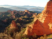
, such as the very much larger site of alluvial mining at Las Medulas
Las Médulas
Las Médulas is a historical site near the town of Ponferrada in the region of El Bierzo , which used to be the most important gold mine in the Roman Empire...
and Montefurado. The Romans may have used slave labour taken from the local area to work the mine, although the army itself was probably most directly involved, especially for their engineering skills in surveying and building aqueducts, reservoirs and water tanks or cistern
Cistern
A cistern is a waterproof receptacle for holding liquids, usually water. Cisterns are often built to catch and store rainwater. Cisterns are distinguished from wells by their waterproof linings...
s.
Gold
Gold is a chemical element with the symbol Au and an atomic number of 79. Gold is a dense, soft, shiny, malleable and ductile metal. Pure gold has a bright yellow color and luster traditionally considered attractive, which it maintains without oxidizing in air or water. Chemically, gold is a...
was worked at the site, judging by the finished brooch shown above, as well as other finished gold products.
A part engraved jewel
Gemstone
A gemstone or gem is a piece of mineral, which, in cut and polished form, is used to make jewelry or other adornments...
has also been found in the vicinity. Such activities would have needed skilled, not slave labour. No workshops or furnaces have yet been found, but it is likely that both existed on site. Ingots of gold would have been easier to transport than dust or nuggets, although a high-temperature refractory
Refractory
A refractory material is one that retains its strength at high temperatures. ASTM C71 defines refractories as "non-metallic materials having those chemical and physical properties that make them applicable for structures, or as components of systems, that are exposed to environments above...
furnace
Furnace
A furnace is a device used for heating. The name derives from Latin fornax, oven.In American English and Canadian English, the term furnace on its own is generally used to describe household heating systems based on a central furnace , and sometimes as a synonym for kiln, a device used in the...
will have been needed to melt the gold, which has a melting point
Melting point
The melting point of a solid is the temperature at which it changes state from solid to liquid. At the melting point the solid and liquid phase exist in equilibrium. The melting point of a substance depends on pressure and is usually specified at standard atmospheric pressure...
of 1064 °C. Pliny mentions such special furnaces in his Naturalis Historia
Naturalis Historia
The Natural History is an encyclopedia published circa AD 77–79 by Pliny the Elder. It is one of the largest single works to have survived from the Roman Empire to the modern day and purports to cover the entire field of ancient knowledge, based on the best authorities available to Pliny...
. A workshop
Workshop
A workshop is a room or building which provides both the area and tools that may be required for the manufacture or repair of manufactured goods...
will have been vital for building and maintaining mining equipment such as the drainage wheels, flume
Flume
A flume is an open artificial water channel, in the form of a gravity chute, that leads water from a diversion dam or weir completely aside a natural flow. Often, the flume is an elevated box structure that follows the natural contours of the land. These have been extensively used in hydraulic...
s for washing tables, shuttering for aqueducts, crushing equipment and pit-props. Official mints would have produced gold coin
Gold coin
A gold coin is a coin made mostly or entirely of gold. Gold has been used for coins practically since the invention of coinage, originally because of gold's intrinsic value...
s, a key component of Roman currency
Roman currency
The Roman currency during most of the Roman Republic and the western half of the Roman Empire consisted of coins including the aureus , the denarius , the sestertius , the dupondius , and the as...
. After the military occupation the mine may have been taken over by Romano-British
Romano-British
Romano-British culture describes the culture that arose in Britain under the Roman Empire following the Roman conquest of AD 43 and the creation of the province of Britannia. It arose as a fusion of the imported Roman culture with that of the indigenous Britons, a people of Celtic language and...
civilian contractors some time after 125 AD, although the final history of the site has yet to be determined.
Later history
Following the Roman departure from Britain in the 5th century, the mine lay abandoned for centuries. There was a revival in the 19th century and attempts to make successful ventures at the site in the early 20th century, but they were abandoned before the first world war. In the 1930s a shaft was sunk to 430 feet in an attempt to locate new seams. Falling into disrepair and unsafe due to flooding at its lower levels, the mine finally closed in 1938. It was during this period that ancient underground workings were found, and the fragment of the dewatering mill discovered within. The extensive surface remains, especially the traces of hydraulic mining, were to be discovered only in the 1970s by intensive fieldwork and surveying.Between 1975 and 2000 the lease to the underground workings at Dolaucothi was held by Cardiff University. Students from the School of Engineering were largely responsible for the renovation of the underground workings that were made safe for tourists. The mine was extensively used as a training mine for Mining Engineering and Exploration Geology students under the supervision of Drs. Alun Issac, Alwyn Annels and Peter Brabham. Students from the School of Earth Sciences carried out an active gold exploration programme using surface and underground diamond drilling techniques, geochemical soil sampling and geophysics.Geological exploration was carried out by students using both surface and underground drilling methods. The ore processing waste tailings dam was also sampled, mapped geophysically and assessed for its Gold potential. The mine was extensively mapped and a library of Dolaucothi data is still held at the School of Earth & Ocean Sciences at Cardiff University. Cardiff University finally gave up the lease to the underground workings in 2000 due to the closure of its BSc Mining Engineering degree course. Photographs of surface and underground activities from the Cardiff University archives can be found from the links below.
Although there is yet no comparable site in Britain, it is likely that field work will locate other mines, simply by tracing the remains of aqueducts and reservoirs, and often, if not usually, aided by aerial photography
Aerial photography
Aerial photography is the taking of photographs of the ground from an elevated position. The term usually refers to images in which the camera is not supported by a ground-based structure. Cameras may be hand held or mounted, and photographs may be taken by a photographer, triggered remotely or...
. Physical remains like tanks and aqueducts are often recognised by the shadows cast by the structures in oblique lighting conditions. Thus Tank A was first seen in early morning light when the sun's rays cast an oblique light across the hill (Allt Cwmhenog) on which the structure is situated.
Other local mines
The leadLead
Lead is a main-group element in the carbon group with the symbol Pb and atomic number 82. Lead is a soft, malleable poor metal. It is also counted as one of the heavy metals. Metallic lead has a bluish-white color after being freshly cut, but it soon tarnishes to a dull grayish color when exposed...
mines of Nantymwyn near Rhandirymwyn village some 8 miles away to the north may also have been first worked by the Romans, judging by hushing
Hushing
Hushing is an ancient and historic mining method using a flood or torrent of water to reveal mineral veins. The method was applied in several ways, both in prospecting for ores, and for their exploitation. Mineral veins are often hidden below soil and sub-soil, which must be stripped away to...
tanks and aqueducts found there in the 1970s both from fieldwork and aerial photographs. They occur at the top of the mountain called Pen-cerrig-mwyn, and the veins were followed underground by several tunnels leading to the workings. Inside, the veins have been removed and debris carefully stacked within the stope. The workings lie far above the later modern mines and processing plant (now derelict). The later mine was once the largest lead mine in Wales.
Other local sites
There are Roman forts at LlandoveryLlandovery
Llandovery is a market town in Carmarthenshire, Wales, lying on the River Tywi and the A40 road.The town is served by Llandovery railway station, where there is a park and ride to Llanelli and Shrewsbury via the Heart of Wales Line...
and Bremia (fort) near Llanio, and as of 2003, in Llandeilo
Llandeilo
Llandeilo is a town in Carmarthenshire, Wales, situated at the crossing of the River Towy by the A483 on a 19th century stone bridge. Its population is 1,731.The town is served by Llandeilo railway station on the Heart of Wales Line.- Early history :...
.
National Trust
The United KingdomUnited Kingdom
The United Kingdom of Great Britain and Northern IrelandIn the United Kingdom and Dependencies, other languages have been officially recognised as legitimate autochthonous languages under the European Charter for Regional or Minority Languages...
's National Trust
National Trust for Places of Historic Interest or Natural Beauty
The National Trust for Places of Historic Interest or Natural Beauty, usually known as the National Trust, is a conservation organisation in England, Wales and Northern Ireland...
has owned and run the Dolaucothi gold mine and Dolaucothi Estate
Dolaucothi Estate
The Dolaucothi Estate, or as it was often later spelt, Dolaucothy Estate is situated about one mile north-west of the village of Caio in the upper reaches of the picturesque Cothi valley in the parish of Cynwyl Gaeo, Carmarthenshire...
since 1941 when it was bequeathed by descendants of the Johnes family who had owned the mine and large surrounding estate since the late 16th century. Manchester and Cardiff Universities were active in exploring the extensive remains in the 1960s and 70s and Lampeter University is now closely involved with the archaeology
Archaeology
Archaeology, or archeology , is the study of human society, primarily through the recovery and analysis of the material culture and environmental data that they have left behind, which includes artifacts, architecture, biofacts and cultural landscapes...
of the site. The National Trust organises guided tours for visitors, showing them the mine and the Roman archaeology.
See also
- Aerial archaeologyAerial archaeologyAerial archaeology is the study of archaeological remains by examining them from altitude.The advantages of gaining a good aerial view of the ground had been long appreciated by archaeologists as a high viewpoint permits a better appreciation of fine details and their relationships within the wider...
- De architecturaDe architectura' is a treatise on architecture written by the Roman architect Vitruvius and dedicated to his patron, the emperor Caesar Augustus, as a guide for building projects...
- De aquaeductuDe aquaeductu' is a two-book official report given to the emperor on the state of the aqueducts of Rome, and was written by Julius Sextus Frontinus at the end of the 1st century AD. It is also known as or . It is the earliest official report of an investigation made by a distinguished citizen on Roman...
- De re metallicaDe re metallicaDe re metallica is a book cataloguing the state of the art of mining, refining, and smelting metals, published in 1556. The author was Georg Bauer, whose pen name was the Latinized Georgius Agricola...
- Dolaucothi EstateDolaucothi EstateThe Dolaucothi Estate, or as it was often later spelt, Dolaucothy Estate is situated about one mile north-west of the village of Caio in the upper reaches of the picturesque Cothi valley in the parish of Cynwyl Gaeo, Carmarthenshire...
- Fire-settingFire-settingFire-setting is a method of mining used since prehistoric times up to the Middle Ages. Fires were set against a rock face to heat the stone, which was then doused with water...
- Frontinus
- Georg AgricolaGeorg AgricolaGeorgius Agricola was a German scholar and scientist. Known as "the father of mineralogy", he was born at Glauchau in Saxony. His real name was Georg Pawer; Agricola is the Latinised version of his name, Pawer meaning "farmer"...
- Gold dustGold DustGold dust refers to fine particles of gold produced by machining or occurring naturally.Gold dust may also refer to:*Goldust, the ring name of Dustin Rhodes, an American wrestler...
- Gold miningGold miningGold mining is the removal of gold from the ground. There are several techniques and processes by which gold may be extracted from the earth.-History:...
- Gold extractionGold extractionGold extraction or recovery from its ores may require a combination of comminution, mineral processing, hydrometallurgical, and pyrometallurgical processes to be performed on the ore....
- Gold prospectingGold prospectingGold prospecting is the act of searching for new gold deposits. Methods used vary with the type of deposit sought and the resources of the prospector...
- HushingHushingHushing is an ancient and historic mining method using a flood or torrent of water to reveal mineral veins. The method was applied in several ways, both in prospecting for ores, and for their exploitation. Mineral veins are often hidden below soil and sub-soil, which must be stripped away to...
- Hydraulic miningHydraulic miningHydraulic mining, or hydraulicking, is a form of mining that uses high-pressure jets of water to dislodge rock material or move sediment. In the placer mining of gold or tin, the resulting water-sediment slurry is directed through sluice boxes to remove the gold.-Precursor - ground...
- Las MedulasLas MédulasLas Médulas is a historical site near the town of Ponferrada in the region of El Bierzo , which used to be the most important gold mine in the Roman Empire...
- Mining archaeology in British IslesMining archaeology in British IslesMining Archaeology is a specific field well developed in the British Isles during recent decades. A reason of ongoing interest in this field is the particular bond between regional history and the exploitation of metals. References to mines in the area exist in Strabo’s works. However the first...
- Mining in Roman BritainMining in Roman BritainMining was one of the most prosperous activities in Roman Britain. Britain was rich in resources such as copper, gold, iron, lead, salt, silver, and tin, materials in high demand in the Roman Empire. The abundance of mineral resources in the British Isles was probably one of the reasons for the...
- Naturalis HistoriaNaturalis HistoriaThe Natural History is an encyclopedia published circa AD 77–79 by Pliny the Elder. It is one of the largest single works to have survived from the Roman Empire to the modern day and purports to cover the entire field of ancient knowledge, based on the best authorities available to Pliny...
- Placer miningPlacer miningPlacer mining is the mining of alluvial deposits for minerals. This may be done by open-pit or by various surface excavating equipment or tunneling equipment....
- Pliny the ElderPliny the ElderGaius Plinius Secundus , better known as Pliny the Elder, was a Roman author, naturalist, and natural philosopher, as well as naval and army commander of the early Roman Empire, and personal friend of the emperor Vespasian...
- River CothiRiver CothiThe River Cothi is the largest tributary of the River Tywi in south Wales. It is noted for its trout and sea trout fishing and for its beautiful scenery.-Dolaucothi:...
- Roman aqueducts
- Roman engineeringRoman engineeringRomans are famous for their advanced engineering accomplishments, although some of their own inventions were improvements on older ideas, concepts and inventions. Technology for bringing running water into cities was developed in the east, but transformed by the Romans into a technology...
- Roman mining
- Roman technologyRoman technologyRoman technology is the engineering practice which supported Roman civilization and made the expansion of Roman commerce and Roman military possible over nearly a thousand years....
- Roman armyRoman armyThe Roman army is the generic term for the terrestrial armed forces deployed by the kingdom of Rome , the Roman Republic , the Roman Empire and its successor, the Byzantine empire...
- VitruviusVitruviusMarcus Vitruvius Pollio was a Roman writer, architect and engineer, active in the 1st century BC. He is best known as the author of the multi-volume work De Architectura ....
External links
- A set of Dolaucothi photographic images by Dr Peter Brabham of Cardiff University
- Dolaucothi Gold Mines information at the National Trust
- An interactive quiz relating to Dolaucothi Gold Mine. Includes an animation of a water wheel used to empty the Dolaucothi Gold Mine of water.
- Description of site by Cadw
- Cultural jewels of Wales (under metal mining and manufacturing)
- Early reference
- Spanish site dedicated to Roman technology, especially aqueducts and mines
- Roman gold mine at Bessa, Italy
- Las Médulas (Spain). Largest Roman gold mine
- Roman lead mines and later mines near Dolaucothi