

Mataura
Encyclopedia
South Island
The South Island is the larger of the two major islands of New Zealand, the other being the more populous North Island. It is bordered to the north by Cook Strait, to the west by the Tasman Sea, to the south and east by the Pacific Ocean...
of New Zealand. Mataura has a meat processing plant, and until 2000 it was the site of a large pulp and paper
Paper
Paper is a thin material mainly used for writing upon, printing upon, drawing or for packaging. It is produced by pressing together moist fibers, typically cellulose pulp derived from wood, rags or grasses, and drying them into flexible sheets....
mill.
Mataura is also the setting for Dunedin
Dunedin
Dunedin is the second-largest city in the South Island of New Zealand, and the principal city of the Otago Region. It is considered to be one of the four main urban centres of New Zealand for historic, cultural, and geographic reasons. Dunedin was the largest city by territorial land area until...
crime fiction author Vanda Symon
Vanda Symon
Vanda Symon is a crime writer and radio host from Dunedin, New Zealand, and the Chair of the Otago Southland Branch of the New Zealand Society of Authors.-Life:...
's debut novel, Overkill
Overkill (novel)
The first novel by New Zealand writer Vanda Symon. Overkill, was published in March 2007 in New Zealand by Penguin Books.-Plot:When the body of a young mother is found washed up on the banks of the Mataura River a small rural community is rocked by her tragic suicide. But all is not what it seems...
.
Geography
It is situated on State Highway 1State Highway 1 (New Zealand)
State Highway 1 is the longest and most significant road in the New Zealand roading network, running the length of both main islands. It appears on road maps as SH 1 and on road signs as a white number 1 on a red shield, but it has the official designations SH 1N in the North Island, SH 1S in the...
and the Main South Line
Main South Line
The Main South Line, sometimes referred to as part of the South Island Main Trunk Railway, is a railroad line that runs north and south from Lyttelton in New Zealand through Christchurch and along the east coast of the South Island to Invercargill via Dunedin...
railway, on the eastern fringe of the Southland Plain 13 kilometres south west of Gore
Gore, New Zealand
Gore is a town, surrounding borough, and district in the Southland region of the South Island of New Zealand.-Geography:The Gore District has a land area of 1,251.62 km² and a resident population of...
and 53 kilometres north east of Invercargill
Invercargill
Invercargill is the southernmost and westernmost city in New Zealand, and one of the southernmost cities in the world. It is the commercial centre of the Southland region. It lies in the heart of the wide expanse of the Southland Plains on the Oreti or New River some 18 km north of Bluff,...
. On the southern side of the town, State Highway 96
New Zealand State Highway network
The New Zealand State Highway network is the major national highway network in New Zealand. Just under 100 roads in both the North and South Islands are State Highways...
diverges from SH 1 and runs westward through nearby communities such as Te Tipua
Te Tipua
Te Tipua is a locality in the eastern Southland Region of New Zealand's South Island. It is west of the nearest town, Mataura, and northeast of Southland's major centre, Invercargill. State Highway 96 passes through Te Tipua as it runs between Waitane and its junction with State Highway 1 on the...
and Waitane
Waitane
Waitane is a locality in the Southland Region of New Zealand's South Island in the foothills of the Hokonui Hills. It is located in a rural setting on State Highway 96 between Glencoe and Te Tipua. The nearest sizeable town is Mataura to the east, while the main city of Southland, Invercargill,...
, ultimately terminating in Ohai
Ohai
Ohаi is a town in the Southland Region of New Zealand's South Island. It is located 65 kilometres northwest of Invercargill and 25 kilometres west of Winton. The 2001 New Zealand Census of Population and Dwellings gave its population as 399, a decline of 22.2% or 114 people since the 1996...
. The town straddles the Mataura River
Mataura River
The Mataura River is in the Southland Region of the South Island of New Zealand. It is 190 kilometres in length.The river's headwaters are located in mountains to the south of Lake Wakatipu. From there it flows southeast towards Gore, where it turns southward...
which flows south through the town and is a source of brown trout. On the northern outskirts of the town the river falls over a bed of sandstone 6.1 metres (20 ft) high to create the Mataura Falls which is known by local Maori as Te Aunui (the great current).
The land rises to the Hokonui Hills 13 km to the north-west, while to the east is a series of hills.
Population
The town's population was 1,560 at the 2006 census. This compares with a population of 1,715 in 1951 and 2,085 in 1961.History
While there was no permanent Maori settlement in the present day location of Mataura prior to the arrival of European settlers, the location was well known to local Maori for the harvest of lamprey (which they called ‘kana kana’) in October of each year as they made their annual passage up the falls. The closest Maori settlement was the kaik (unfortified village) of Tuturau, which was located near the east bank of the Mataura River 3.2 km (2 mi) downstream from the present town. In 1836 this village was the scene of the last act of Maori warfare in the South Island. A war party of approximately 70 members of the Ngāti Tama and Te Āti AwaTe Ati Awa
Te Āti Awa is a Māori iwi with traditional bases in the Taranaki and Wellington regions of New Zealand. Approximately 17,000 people registered their affiliation to Te Āti Awa in 2001, with around 10,000 in Taranaki, 2,000 in Wellington and around 5,000 of unspecified regional location.-Geographical...
tribes under the command of Te Puoho, chief of the Ngati Tama tribe and an ally of Te Rauparaha
Te Rauparaha
Te Rauparaha was a Māori rangatira and war leader of the Ngāti Toa tribe who took a leading part in the Musket Wars. He was influential in the original sale of conquered Rangitane land to the New Zealand Company and was a participant in the Wairau Incident in Marlborough...
attacked and occupied the village which was later retaken by the local Ngāi Tahu
Ngāi Tahu
Ngāi Tahu, or Kāi Tahu, is the principal Māori iwi of the southern region of New Zealand, with the tribal authority, Te Rūnanga o Ngāi Tahu, being based in Christchurch and Invercargill. The iwi combines three groups, Kāi Tahu itself, and Waitaha and Kāti Mamoe who lived in the South Island prior...
under the leadership of Hone Tuhawaiki
Tuhawaiki
Tuhawaiki — often known as Hone Tuhawaiki, John Tuhawaiki or Jack Tuhawaiki, or by his nickname of "Bloody Jack" — became a paramount chief of the Ngāi Tahu Māori iwi in the southern part of the South Island of New Zealand...
(paramount chief of the Ngāi Tahu) and Te Matenga Taiaroa who had been at the Bluff when news of the war party’s presence in the Southland came.
Arrival of the Europeans
In 1854 the MurihikuMurihiku
Murihiku is a Māori name describing a region of the South Island in New Zealand. Traditionally it was used to describe the portion of the South Island below the Waitaki River, but now is mostly used to describe the province of Southland. The name means "the tail end of the land" in...
block of land (which included Mataura) was purchased from local Maori by the Otago Provincial Council, with the objective of developing it up for settlement by immigrants from Great Britain.
At the time travellers between Southland and Otago were drawn to the Mataura area by the presence of the Tuturau ford located about 3.2 km downstream of the falls and the northern ford which was located approximately 1.6 km (0.994196378639691 mi) above the falls.
By 1856 the Otago Provincial Council had recognised that if development was to succeed a ferry had to be established at the falls to enable a direct overland transport between Dunedin and Invercargill. At the time the only alternative route was going by sea along the dangerous southern coast.
In 1859 the Otago Provincial Government built a wooden truss bridge which rested on a large rock in the middle of the falls and was suitable only for foot traffic with large animals and vehicles restricted to crossing on the ferry. As the bridge was always wet and slippery with spray from the falls, the face of the falls was removed by dynamite which moved the falls upstream. This work which damaged the look of the falls was in vain as the bridge was totally destroyed by a major flood on 22 April 1861. To encourage use of the bridge the council also built the Mataura Ferry Hotel on the west bank of the river. This was leased to John MacGibbon who with his family were the first inhabitants of the settlement and as part of his 7 year lease had the right to charge a toll on anyone crossing the river within a mile below and above the falls. At the time the only other Europeans living in the area were John Turnbull who owned the Tuturau Run and the Shanks family who owned the Marairua Run.
The loss of the bridge meant that travellers reverted to using the ferry which had been established north of the falls.
In 1866 James Pollack won the tender for the lease of the Mataura Ferry Hotel and offered to build a replacement bridge in return for the right to charge tolls for 12 years. His offer was declined by the Otago Provincial Government who built a replacement bridge of the suspension type, which was opened on 27 August 1868. Crossing the gorge downstream of the falls it was a more substantial timber structure with 16 supporting cables passing over stone pillars before being anchored in rock. A footbridge was added in 1898.
In response to the commencement on construction on the new bridge James Pollack built the Bridge Hotel on the east bank of the river by the bridge and sold the Mataura Ferry Hotel. He also petitioned the government to undertake the first survey of the location which subsequently named the area the Town of Mataura Bridge.
As a major mail coach stop on the route from Dunedin to Invercargill the bridge soon attracted a number of businessman who set up premises on the east bank around an area called Bridge Square. The construction of the telegraph line between Dunedin and Invercargill which passed through the town lead to the establishment in December 1868 of the first post and telegraph office in the Mataura Valley. This consolidated the settlement’s position as a major transportation and communications hub. This in turn led to it attracting more businessmen, and becoming a major service centre. As a result of this growth a school was established in 1870. The moving of the former Mataura Ferry Hotel (by now renamed Cameron’s Hotel) downstream to a location on the west bank where it was better able to service the passing traffic initiated development on the west bank which was assisted by the surveying of the west and north Mataura in 1874.
In 1875 a railway line was built from Gore to Mataura which in conjunction with establishment of the Mataura Paper Mill helped the town evolve and develop into the major industrial centre in Eastern Southland.
Replacement of the Bridge
By the 1930s the narrowest of the bridge which restricted travel to one direction at a time and its light construction had become inadequate for the increasing traffic and heavy loads. As a result a new bridge was constructed by the Ministry of Works immediately upstream of the suspension bridge (which was subsequently demolished) and opened on July 1939 by Bob SempleBob Semple
Robert "Bob" Semple was a union leader and later Minister of Public Works for the first Labour Government of New Zealand....
, the Minister of Works. It was a single span bow-arch reinforced concrete 53.8 metres (176 ft 6 inches) in length.
Local government
Prior to 1882 local government had been undertaken first by the Tutarau Wardens and then by the Tutarau Road Board. On 29 March 1892 a newly established Town Board took over local government administration of the town’s affairs and representation of the town’s 70 ratepayers.The town’s affairs remained under the administration of the Town Board until 1895 when it changed to the Mataura Borough Council. In 1989 the Mataura Borough Council was merged into the Gore District Council.
Mayors
- Thomas Culling 1895 to 1897. Prior to becoming the borough’s first mayor he had been chairman of the town board.
- Hugh Cameron.
- Thomas MacGibbon.
- John Lowden 1903 to 1906.
- John Galt 1906 to 1909.
- Andrew Balneaves 1909 to 1912.
- Forrest William Brown 1915 to 1917.
- Charles Donohue McConnell 1919 to 1935, 1938 to 1950.
- John Buchanan 1935 to 1938.
- James William Ingram 1950 to 1959.
- Malcolm Tulloch 1959 to 1962.
- S.I.L (Logie) McKelvie 1962 to 1970.
- Keith Raymond Henderson 1970 to 1982.
- Ian (Inky) Tulloch 1982 to 1989. The last mayor of the town before it became part of the Gore District Council.
Education
Children receive their primary school education at Mataura Primary School. Children of immediate and secondary school age are bussed to Gore to continue their education there.Electricity Supply
Because it had surplus generation capacity the freezing works had since 1905 been supplying electricity to the nearby town of Gore, while due to the town’s financial situation Mataura residents were still using candles and kerosene powered lamps. It wasn’t until 1911 the Borough Council was able to reach agreement with the freezing works for them to increase their generating capacity so that they could supply the Mataura load. After taking out a loan to finance the expansion of the generation capacity and the installation of a distribution system around the town the first power began being supplied from 5 October 1912.Mataura retained its own independent power system until 1932 when due to technical issues it became impossible for the freezing works to continue supplying the town. As a result the borough council accepted an offer to sell their power system to the Southland Electric Power Board, which took over responsibility for supplying the town from its distribution network.
Mataura Dairy Factory
In January 1887 a company was formed to construct and operate a dairy factory. After procuring land a factory was constructed and up and running by November of that year. Water for use in the milk and cheese making processes was obtained from a private spring while power was provide by a steam engine powered by local lignite. It was not until 1917 that the factory converted to electric power from the local distribution network. By the early 1970s the company was in financial trouble and closed in May 1980, when diary processing in the area was concentrated at the EdendaleEdendale
Edendale may refer to:*Edendale, former name of Eden Landing, California*Edendale, Los Angeles, California, historical district in Los Angeles*Edendale, Merced County, California, former community*Edendale, New Zealand, town in the Southland region...
Dairy Factory.
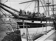
Mataura Paper Mill
In the mid 1870s a company led by James Bain was formed in Invercargill to establish a paper mill on the east bank of the river downstream of the Mataura falls, using water collected from upstream of the falls to provide cheap power to the paper making machinery. The company had installed obsolete second hand machinery, leading to the mill being unprofitable and in 1884 it was sold to Dunedin based Coulls Culling and Co. By 1888, under the direction of Thomas Culling, the company had installed new machinery. In 1891 the paper mill and the freezing works jointly built a weir to a race to improve the water supply to their respective hydro generators. In 1892 the mills became profitable, and by 1895 the paper mill was employing 54 staff.By 1905 as a means of ending an unprofitable price war between Mataura Falls Paper Mill, Otago Paper Mills at Woodhaugh near Dunedin and Riverhead Paper Mills at Auckland these companies amalgamated into a new company called the New Zealand Paper Mills. In 1913 the mill was badly damaged by a major flood, which took a month to repair.
In 1923 a second paper making machine designated No.3 was transferred from the Riverhead mill (which was subsequently closed) to join the No.2 machine, which up till then had been the only machine at the mill. At the same time a new machine designated the No.4 was installed.
In 1936 a new paper making machine designated the No.5 machine was installed.
In 1960 Fletchers Ltd bought an interest in the company. As a result of their injection of new capital the mill was completely modernised. In 1964 NZ Forest Products took a 30% share in the company with Fletchers having 30%. On 8 July 1970 NZ Forest Products took complete ownership of New Zealand Paper Mills.
In 1976 the mill celebrated its centennial year.
By 1990 the mill, owned by NZ Forest Products, had become a division of Elder Resources, until it was taken over by Carter Holt Harvey
Carter Holt Harvey
Carter Holt Harvey Limited is an Australasian forest products company, with significant interests in wood products, pulp, paper and packaging. The company employs approximately 10,500 people across Australasia. Carter Holt Harvey's head New Zealand office is located at 173 Captain Springs Road in...
in 1991. Between 1984 and 1991, due to upgrades and efficiency gains, productively had increased by 25% with 216 staff employed at the end of the period. By 1997 the mill was producing approximately 25,000 tonnes of paper products per year. The mill’s equipment was powered by a combination of onsite hydro power, steam boilers powered by local coal and supply from the local grid.
By the late 20th century the mill was coming under intense pressure from Asian competitors which had depressed the world price for paper, and as a result the mill was losing NZ$1 million a year. Faced with these losses and forecasts that they would continue, and with the mill contributing only 3% of Carter Harvey Holt output by volume, the company closed the mill on 18 August 2000 with 155 staff being made redundant.
Mataura Flour Mill
As a result of concerns expressed by local citizens about the proposed new paper mill’s proposal to secure sole rights to harnessing all the electrical potential of the falls, the paper mill’s proprietors obtained the goodwill of the citizens by building a flour mill on the west bank. The 3 grinding stones in the mill were driven by a water wheel.The flour mill was demolished in 1893 to make room for the freezing works.
Mataura Freezing Works
The Southland Frozen Meat And Produce Export Company (which had been established in 1882) purchased land on the west bank of the river from Thomas Culling (the principal of the Mataura Paper Mills) upon which they built and opened the second freezing (meat processing) works in Southland. At the time eastern Southland sheep farmers tended to send their livestock by rail to Dunedin for slaughtering and it was intended that the new works would compete for this businessThe plant opened on 21 April 1893, with freezing starting 4 days later. The complex’s machinery was powered by electricity from a hydro generator powered by water diverted from the falls. A steam engine provided backup power. By early May production had increased to 300 carcasses a day. The complex at the time of its opening featured 3 freezing chambers, each capable of holding 600 caresses. The storerooms could accommodate 16,000 carcasses, which by 1897 had been increased to 24,000 carcasses.
By 1905 40 to 50 people were being employed at the works.
In 1931 a new slaughter board was installed in the complex.
In 1947 to 1948 season the slaughterhouse changed over from solo butchering to the chain system of slaughtering livestock. Whereas previously one man took responsibility for butchering an animal from start to finish, with the chain system one man was limited to undertaking one task. Compared with the previous system where the workers were permanent residents of the town the chain system lead to increasing numbers of seasonal workers who lived in the town only during the killing season
In 1982 a methane plant was installed which allowed the complex to supply more of its power demand.
After a series of takeovers the Mataura works came under the ownership of Alliance Group Limited in 1989. The works currently undertakes the processing of lamb, sheep, cattle and bobby calves and due to intensive development and expansion throughout its history extends for some distance along the bank of the river, sandwiched between it and State Highway 1.
Fibreboard manufacturing
In 1997 Rayonier NZ limited opened on a greenfield site a medium-density fibreboard (MDF) manufacturing plant at Brydone, 8 kilometres south of Mataura.The facility was subsequently purchased by Dongwha in 2005. Renamed as the Patinna mill it specializes in thin and high density fibreboard products with 90% of its output exported.
Famous Mataura Citizens
- Justin MarshallJustin MarshallJustin Warren Marshall, MNZM is a New Zealand rugby union footballer. He was born in Mataura and educated in Gore before settling in Christchurch. Marshall played 81 games for the New Zealand All Blacks between 1995 and 2005...
- All Black Half Back - Jimmy CowanJimmy CowanQuinton James Cowan is a New Zealand rugby union footballer. He has been an All Black since 2004 where he made his debut during the 2004 tour to the United Kingdom and France. Cowan was born in Gore and attended Gore High School...
- All Black Half Back - Lloyd Ashby - All Black Full Back
Cardigan Bay
Mataura is the birth place of Cardigan BayCardigan Bay (horse)
Cardigan Bay was a New Zealand Harness racing horse foaled 1 September 1956. Affectionately known as "Cardy", he was the first Standardbred to win US$1 million in prize money in North America. He was the ninth horse worldwide to win one million dollars,...
, the famous New Zealand pacer. Cardigan Bay was the first standardbred to win $1,000,000.
Further reading
- Williams, Jolene. The Business History of the Mataura Paper Mills 1976 to 2000. http://www.sapphire.ac.uk/Mataura%20history%20report.pdf Retrieved 25 June 2010.
- Mataura Ensign 1887. A Visit to the Mataura Works. Accessed 25 June 2010. http://paperspast.natlib.govt.nz/cgi-bin/paperspast?a=d&d=ME18970320.2.12&l=mi&e=-------10--1----2-all