Lake Hawea
Encyclopedia

Otago
Otago is a region of New Zealand in the south of the South Island. The region covers an area of approximately making it the country's second largest region. The population of Otago is...
Region of New Zealand
New Zealand
New Zealand is an island country in the south-western Pacific Ocean comprising two main landmasses and numerous smaller islands. The country is situated some east of Australia across the Tasman Sea, and roughly south of the Pacific island nations of New Caledonia, Fiji, and Tonga...
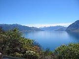
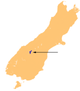
, at an altitude of 348 metres. It covers an area of some 141 km² and is, at its deepest, 392 metres deep. Its name is Māori
Maori language
Māori or te reo Māori , commonly te reo , is the language of the indigenous population of New Zealand, the Māori. It has the status of an official language in New Zealand...
, and is thought to be named after a local tribe though the exact meaning is uncertain.
In 1958 the lake was raised artificially by 20 metres to store more water for increased hydroelectric power generation.
At its greatest extent, which is roughly along a north-south axis, the lake is 35 kilometres long. It lies in a glacial valley
U-shaped valley
A U-shaped valley also known as a glacial trough is one formed by the process of glaciation. It has a characteristic U-shape, with steep, straight sides, and a flat bottom. Glaciated valleys are formed when a glacier travels across and down a slope, carving the valley by the action of scouring...
formed during the last ice age, and is fed by the Hunter River. Nearby Lake Wanaka
Lake Wanaka
Lake Wanaka is located in the Otago region of New Zealand, at an altitude of 300 metres. Covering an area of , it is New Zealand's fourth largest lake, and estimated to be more than deep...
lies in a parallel glacial valley eight kilometres to the west. At their closest point (a rocky ridge called The Neck), the lakes are only 1000 metres apart. Lake Hawea is dammed to the south by an ancient terminal moraine
Terminal moraine
A terminal moraine, also called end moraine, is a moraine that forms at the end of the glacier called the snout.Terminal moraines mark the maximum advance of the glacier. An end moraine is at the present boundary of the glacier....
created some 10,000 years ago.
The only flat land around the lake is at its southern end, surrounding its outflow into the Hawea River, a short tributary of the Clutha
Clutha River
The Clutha River / Mata-Au is the second longest river in New Zealand flowing south-southeast through Central and South Otago from Lake Wanaka in the Southern Alps to the Pacific Ocean, south west of Dunedin. It is the highest volume river in New Zealand, and the swiftest, with a catchment of ,...
, which it joins near Albert Town
Albert Town, New Zealand
Albert Town is located to the east of Wanaka in Otago, New Zealand. Until recently only a farming settlement, the population boom in this area has led to much new development. The confluence of the Clutha and Cardrona Rivers is located here. The town was named after Prince Albert of Saxe-Coburg and...
. The settlement of Hawea
Hawea
Hawea is the name of a small settlement at the southern end of Lake Hawea, in New Zealand's South Island. It is located 18 kilometres to the northeast of Wanaka....
is found at the lake's southern shore.
The lake is a popular resort, and is well used in the summer for fishing
Fishing
Fishing is the activity of trying to catch wild fish. Fish are normally caught in the wild. Techniques for catching fish include hand gathering, spearing, netting, angling and trapping....
, boating and swimming. The nearby mountains and fast-flowing rivers allow for adventure tourism year-round, with jetboat
Jetboat
A jetboat is a boat propelled by a jet of water ejected from the back of the craft. Unlike a powerboat or motorboat that uses a propeller in the water below or behind the boat, a jetboat draws the water from under the boat into a pump inside the boat, then expels it through a nozzle at the...
ing and skiing
Skiing
Skiing is a recreational activity using skis as equipment for traveling over snow. Skis are used in conjunction with boots that connect to the ski with use of a binding....
facilities located nearby.
In pre-European history, Hawea had an important role, when, in the 1830s the Māori residents of Hawea brought warning to the residents of the South Island
South Island
The South Island is the larger of the two major islands of New Zealand, the other being the more populous North Island. It is bordered to the north by Cook Strait, to the west by the Tasman Sea, to the south and east by the Pacific Ocean...
east coast of a planned attack over alpine passes by a war party of the warrior Te Puoho.


