

Macleay River
Encyclopedia
Australia
Australia , officially the Commonwealth of Australia, is a country in the Southern Hemisphere comprising the mainland of the Australian continent, the island of Tasmania, and numerous smaller islands in the Indian and Pacific Oceans. It is the world's sixth-largest country by total area...
.
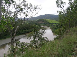
The headwaters of the Macleay River rise as the Gara River on the eastern side of the Northern Tablelands
Northern Tablelands, New South Wales
The Northern Tablelands, also known as the New England Tableland, is a plateau and a region of the Great Dividing Range in northern New South Wales, Australia. It includes the New England Range, the narrow highlands area of the New England region, stretching from the Moonbi Range in the south to...
near Armidale
Armidale, New South Wales
Armidale is a city in the Northern Tablelands, New South Wales, Australia. Armidale Dumaresq Shire had a population of 19,485 people according to the 2006 census. It is the administrative centre for the Northern Tablelands region...
and Walcha, New South Wales
Walcha, New South Wales
Walcha is a parish and town at the south-eastern edge of the Northern Tablelands, New South Wales, Australia.The town serves as the seat of Walcha Shire. Walcha is located 425 kilometres by road from Sydney at the intersection of the Oxley Highway and Thunderbolts Way...
. From here the Chandler River
Chandler River (New South Wales)
The Chandler River is a river of New South Wales in Australia. The headwaters of the Chandler River rise on the eastern slopes of the Northern Tablelands about 43 kilometres north-east of Armidale. It is in the Local Government Area of Armidale Dumaresq Shire. The Chandler River, Wollomombi River,...
, Styx River
Styx River (New South Wales)
The Styx River is a river in New South Wales, Australia.The Styx River rises in the Snowy Range, a spur of the Great Dividing Range, which forms part of the eastern escarpment of the Northern Tablelands. It starts near the village of Ebor....
and Apsley River
Apsley River (New South Wales)
The Apsley River is a river on the Northern Tablelands of New South Wales, Australia. The headwaters of the river rise in high country about 11 kilometres west of Tia and approximately 29 km south of Walcha, New South Wales.- Geography :...
s are important tributaries of the Macleay River. These and the other tributaries including the Tia River
Tia River
The Tia River is a river on the Northern Tablelands of New South Wales, Australia. The headwaters of the river rise in high country on the eastern slopes of the Great Dividing Range about south west of Tia. It flows generally north east crossing the Oxley Highway before spilling over the Tia Falls...
, Dyke River
Dyke River
-References:...
and Yarrowitch River
Yarrowitch River
The Yarrowitch River is a river on the Northern Tablelands of New South Wales, Australia.The headwaters of the river rise in high country on the eastern slopes of the Great Dividing Range about 11 kilometres south west of Yarrowitch. It flows generally north north east crossing the Oxley Highway...
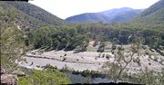
pass through a number of spectacular gorges
Gorges
Gorges, the plural of the French word for "throat", usually refers to a canyon.Gorges is the name or part of the name of several communes in France:* Gorges, in the Loire-Atlantique département* Gorges, in the Manche département...
and waterfalls in the Oxley Wild Rivers National Park
Oxley Wild Rivers National Park
Oxley Wild Rivers National Park is in New South Wales, Australia, 445 kilometres north of Sydney and is named in memory of the Australian explorer John Oxley, who passed through the area in 1818...
. The river flows in a south-easterly direction to the town of Kempsey
Kempsey, New South Wales
Kempsey is a town in the Mid North Coast region of New South Wales, Australia and is the council seat for Kempsey Shire. It is located 15 kilometres inland from the coast of the Pacific Ocean where the Pacific Highway and the North Coast railway line cross the Macleay River...
and after travelling a total of 400 kilometres enters the Pacific Ocean
Pacific Ocean
The Pacific Ocean is the largest of the Earth's oceanic divisions. It extends from the Arctic in the north to the Southern Ocean in the south, bounded by Asia and Australia in the west, and the Americas in the east.At 165.2 million square kilometres in area, this largest division of the World...
at South West Rocks
South West Rocks, New South Wales
South West Rocks is located on the Mid North Coast of New South Wales, Australia, near the mouth of the Macleay River. It is approximately 40 km from Kempsey. Jerseyville is located nearby....
.
History
The Macleay/Apsley RiverApsley River (New South Wales)
The Apsley River is a river on the Northern Tablelands of New South Wales, Australia. The headwaters of the river rise in high country about 11 kilometres west of Tia and approximately 29 km south of Walcha, New South Wales.- Geography :...
Gorges were the tribal area of the Dunghutti people, whose descendants are now concentrated in the lower Macleay River. Archaeological evidence of Aboriginal
Australian Aborigines
Australian Aborigines , also called Aboriginal Australians, from the latin ab originem , are people who are indigenous to most of the Australian continentthat is, to mainland Australia and the island of Tasmania...
camp sites have been found on the upper terraces of the Macleay and Apsley
Apsley River (New South Wales)
The Apsley River is a river on the Northern Tablelands of New South Wales, Australia. The headwaters of the river rise in high country about 11 kilometres west of Tia and approximately 29 km south of Walcha, New South Wales.- Geography :...
Rivers.
John Oxley
John Oxley
John Joseph William Molesworth Oxley was an explorer and surveyor of Australia in the early period of English colonisation.October 1802 he was engaged in coastal survey work including an expedition to Western Port in 1804-05...
, failed to realize the potential of this river in 1820 when he did not navigate far enough up the river to see the magnificent stands of timber and the fertile land. The river was vaguely referred to as the New River from descriptions given by Aborigines. In 1826 Captain Wright travelled overland from Port Macquarie and explored to the head of navigation at Belgrave Falls, a series of rapids to the west of the present town of Kempsey. Then called Wrights River, Major Archibald Clunes Innes
Archibald Clunes Innes
Archibald Clunes Innes was a soldier and pastoralist from Thrumster, Caithness, Scotland. When he arrived in Australia in 1822 he was a captain in the Third Regiment , on the ship “Eliza”, in charge of 170 convicts....
, Commandant of Port Macquarie Penal Settlement, sent the first government gang of Australian red cedar (Toona ciliata
Toona ciliata
Australian Red Cedar , Toona ciliata is a forest tree in the family Meliaceae which grows throughout southern Asia from Afghanistan to Papua New Guinea and Australia. In Australia its natural habitat is now extensively cleared subtropical rainforests of New South Wales and Queensland...
) cutters to work here in 1827.
More cedar camps were established on the Macleay during the 1830s and the area was also a haven for escaped convicts. By 1841, about 200 cutters were working on the river area, where violence and theft of logs was not uncommon. Demand and prices dropped in 1842 and cutting along the Macleay diminished although it continued in the upper tributaries.
When Europeans arrived in the area around the 1820s the river mouth was just south of Grassy Head, and almost a mile wide with a sand spit in the middle. The small town of Stuarts Point was established on the river just inside to serve arriving ships.
The area from what is now South West Rocks
South West Rocks, New South Wales
South West Rocks is located on the Mid North Coast of New South Wales, Australia, near the mouth of the Macleay River. It is approximately 40 km from Kempsey. Jerseyville is located nearby....
around to Grassy Head is a wide delta with various channels connected to the river. Around 1885 English marine engineer John Coode advised on improvements to various rivers and ports in Australia, including the Macleay. The Department of Public Works prepared four plans for improvements to the mouth, Coode favoured improving the existing entrance. In 1893 a flood enlarged an opening near South West Rocks and the department elected to improve that, called the New Entrance, though Coode had thought it not enough to drain all the waters of the district.
Work on the new entrance commenced in April 1896, improving the channel and adding training walls. A new pilot station was built in 1902, establishing the town of South West Rocks
South West Rocks, New South Wales
South West Rocks is located on the Mid North Coast of New South Wales, Australia, near the mouth of the Macleay River. It is approximately 40 km from Kempsey. Jerseyville is located nearby....
. Work was completed in 1906. Today the old mouth has silted up, leaving Stuarts Point on a dead-end reach.
Variously known as Wright River, Trail River, New and McLeay rivers it was named the Macleay River in honour of Innes’s father-in-law, Alexander McLeay
Alexander Macleay
Hon. Alexander Macleay MLC FLS FRS was a leading member of the Linnean Society and a fellow of the Royal Society.Macleay was born on Ross-shire, Scotland, eldest son of William Macleay, provost of Wick...
, Scottish-born scientist and colonial secretary of New South Wales.
The Macleay River is liable to flooding in the Kempsey area, on occasions causing great damage.
The upper reaches of the Macleay River provide some of the best bass
Bass (fish)
Bass is a name shared by many different species of popular gamefish. The term encompasses both freshwater and marine species. All belong to the large order Perciformes, or perch-like fishes, and in fact the word bass comes from Middle English bars, meaning "perch."-Types of basses:*The temperate...
fishing spots in the country.
Interesting facts
The Macleay River has the world's second-fastest flowing currents during flooding.The Macleay River can hold over 200,000 gigalitres (2,000,000,000 litres) of water during a flood time.