

Clutha Mata-Au River Parkway Group
Encyclopedia
Clutha River
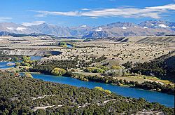
The Clutha River / Mata-Au is the second longest river in New Zealand flowing south-southeast through Central and South Otago from Lake Wanaka in the Southern Alps to the Pacific Ocean, south west of Dunedin. It is the highest volume river in New Zealand, and the swiftest, with a catchment of ,...
Mata-Au River Parkway Group, New Zealand
New Zealand
New Zealand is an island country in the south-western Pacific Ocean comprising two main landmasses and numerous smaller islands. The country is situated some east of Australia across the Tasman Sea, and roughly south of the Pacific island nations of New Caledonia, Fiji, and Tonga...
, was formed in October 2003, and is an Incorporated Society, with Charitable and Donee Status. The Group was set up in response to land development issues along the Clutha Mata-Au River corridor, much of which has high scenic and recreational values. The project aims to establish a regional river parkway, including a river trail, along the entire 338 km river corridor from Lake Wanaka
Lake Wanaka
Lake Wanaka is located in the Otago region of New Zealand, at an altitude of 300 metres. Covering an area of , it is New Zealand's fourth largest lake, and estimated to be more than deep...
to the Pacific Ocean
Pacific Ocean
The Pacific Ocean is the largest of the Earth's oceanic divisions. It extends from the Arctic in the north to the Southern Ocean in the south, bounded by Asia and Australia in the west, and the Americas in the east.At 165.2 million square kilometres in area, this largest division of the World...
.
The mission statement of the group is: 'To protect and improve the natural, recreational, and cultural values of the Clutha Mata-Au River corridor, from Lake Wanaka to the Pacific, by establishing a Clutha Mata-Au River Parkway, including a Clutha River Trail, with an integrated management body to safeguard the public interest with a long-term vision.'
The Parkway Group is working with trail-focused community groups such as the Clutha Gold Trail Trust, and the Upper Clutha Tracks Trust, to create a contiguous trail that is expected to become a popular tourism draw-card, bringing considerable economic benefits to the region, and facilitating further river corridor improvements such as native restoration.
The project was initiated by Lewis Verduyn, a rafting
Rafting
Rafting or white water rafting is a challenging recreational outdoor activity using an inflatable raft to navigate a river or other bodies of water. This is usually done on white water or different degrees of rough water, in order to thrill and excite the raft passengers. The development of this...
operator on the Upper Clutha Mata-Au who has rafted the river since 1981. He became Chairperson of the project and is known as an advocate for river protection and conservation.
The Clutha Mata-Au River is New Zealand's largest and most powerful river. It carves 338km from the Southern Alps
Southern Alps
The Southern Alps is a mountain range extending along much of the length of New Zealand's South Island, reaching its greatest elevations near the island's western side...
to the Pacific Ocean
Pacific Ocean
The Pacific Ocean is the largest of the Earth's oceanic divisions. It extends from the Arctic in the north to the Southern Ocean in the south, bounded by Asia and Australia in the west, and the Americas in the east.At 165.2 million square kilometres in area, this largest division of the World...
, traversing the semi-desert interior of Otago
Otago
Otago is a region of New Zealand in the south of the South Island. The region covers an area of approximately making it the country's second largest region. The population of Otago is...
known as Central Otago
Central Otago
Central Otago is the inland part of the New Zealand region of Otago in the South Island. The area commonly known as Central Otago includes both the Central Otago District and the Queenstown-Lakes District to the west....
.
The waters of the Clutha Mata-Au are clear turquoise in the upper reaches, a characteristic that results from glacial and snow-melt filtering by upland lakes, especially Lake Wanaka. In global terms this is rare, because glacially fed rivers are normally discoloured by rock flour
Rock flour
Rock flour, or glacial flour, consists of fine-grained, silt-sized particles of rock, generated by mechanical grinding of bedrock by glacial erosion or by artificial grinding to a similar size...
. The Clutha Mata-Au is also often listed among the world's swiftest rivers.
Historically, the river has been the focus of intense gold-mining. The Central Otago Gold Rush
Central Otago Gold Rush
The Central Otago Gold Rush was a gold rush that occurred during the 1860s in Central Otago, New Zealand...
began in 1861, and it was this influx of people that led to the establishment of many of the river towns that still exist today, such as Alexandra
Alexandra, New Zealand
Alexandra is a town in the Central Otago district of the Otago region of New Zealand. It is located on the banks of the Clutha River , on State Highway 8, 188 km by road from Dunedin and 33 km south of Cromwell.At the time of the 2006 census, the permanent population was 4,827, an...
, Clyde
Clyde, New Zealand
Clyde is a small town in Central Otago, New Zealand with a population of 918 in 2006. It is located on the Clutha River, between Cromwell and Alexandra....
, and Cromwell
Cromwell, New Zealand
Cromwell is a town in Central Otago in the Otago region of New Zealand.It is situated between State Highway 6 and State Highway 8 leading to the Lindis Pass, 75 km northeast, and Alexandra, 33 km south. The road to Alexandra winds through the Cromwell Gorge...
.
In 1956, a large hydro-electric dam was commissioned at Roxburgh
Roxburgh, New Zealand
Roxburgh is a small New Zealand town of about 600 people in Central Otago. It is in Teviot Valley on the banks of the Clutha River, 40 km south of Alexandra in the South Island. State Highway 8, which links Central Otago with Dunedin city, passes through the town...
, flooding the deep-sided Roxburgh Gorge and several well-known rapids, including the Molyneux Falls and the Golden Falls. Another large dam was commissioned at Clyde in 1992, flooding the Cromwell Gorge
Cromwell Gorge
The Cromwell Gorge is a deep gorge on the Clutha River in the Otago region of New Zealand's South Island. It stretches for 20 km south of the town of Cromwell towards Alexandra....
and the often photographed Cromwell Junction where the silty Kawarau River
Kawarau River
Kawarau River drains Lake Wakatipu, in northwestern Otago, New Zealand. The river flows generally eastwards for about 60 km and passes through the steep Kawarau Gorge until it joins Lake Dunstan near Cromwell. The Shotover River enters it from the north; the Nevis River enters it from the south...
merged reluctantly with the clear Upper Clutha. The Clyde Dam
Clyde Dam
The Clyde Dam, New Zealand's third largest hydroelectric dam, is built on the Clutha River near the town of Clyde. It is owned and operated by Contact Energy.-History:...
was highly controversial, having been mistakenly built above an active earthquake fault-line, the River Channel Fault.
The owners of these dams, Contact Energy, announced in February 2009 that they were revisiting former plans for four more large dams on the Clutha Mata-Au. Some people believe that this development would provide jobs and new lakes for recreation, and that the industrialisation of the river valley is an acceptable consequence. However, the Clutha Mata-Au River Parkway Group strongly opposes further damming of the river, as do many people in the river communities.
In October, 2009, the Clutha Mata-Au River Parkway Group facilitated the formation of the Clutha River Forum, an alliance of conservation groups and concerned individuals throughout Otago and New Zealand, who have resolved to work together to prevent further Think Big
Think Big
The New Zealand Prime Minister Robert Muldoon and his New Zealand National Party government in the early 1980s sponsored Think Big as an interventionist state economic strategy. The Think Big schemes saw the government borrow heavily overseas, running up a large external deficit, and using the...
dams on the Clutha River. Members of the Forum include: Upper Clutha River Guardians, Clutha Mata-Au River Parkway Group, Central Otago Environmental Society (Save Central), Beaumont Residents Group, Lower Clutha River Guardians, Forest & Bird (Dunedin / Central – Lakes). The Forum is campaigning for "Option 5 - NO More Dams".