
Cape Charles, Virginia
Encyclopedia
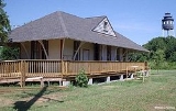
Cape Charles is a town in Northampton County
, Virginia
, United States
. The population was 1,134 at the 2000 census.
According to the United States Census Bureau
, the town has a total area of 4.4 square miles (11.3 km2), of which, 3.7 square miles (9.5 km2) of it is land and 0.7 square miles (1.8 km2) of it (16.06%) is water.
of 2000, there were 1,134 people, 536 households, and 278 families residing in the town. The population density
was 309.4 people per square mile (119.3/km2). There were 740 housing units at an average density of 201.9 per square mile (77.9/km2). The racial makeup of the town was 53.79% White, 42.86% African American, 0.09% Native American, 0.44% Asian, 1.59% from other races
, and 1.23% from two or more races. Hispanic or Latino of any race were 2.82% of the population.
There were 536 households out of which 21.1% had children under the age of 18 living with them, 30.4% were married couples
living together, 19.6% had a female householder with no husband present, and 48.1% were non-families. 43.7% of all households were made up of individuals and 26.3% had someone living alone who was 65 years of age or older. The average household size was 2.11 and the average family size was 2.91.
In the town the population was spread out with 22.1% under the age of 18, 7.1% from 18 to 24, 22.0% from 25 to 44, 25.0% from 45 to 64, and 23.8% who were 65 years of age or older. The median age was 44 years. For every 100 females there were 76.4 males. For every 100 females age 18 and over, there were 75.9 males.
The median income for a household in the town was $22,237, and the median income for a family was $29,167. Males had a median income of $25,536 versus $23,984 for females. The per capita income
for the town was $13,789. About 21.5% of families and 28.4% of the population were below the poverty line, including 43.4% of those under age 18 and 23.0% of those age 65 or over.
, on Virginia's Eastern Shore
, was founded in 1884 as a planned community by railroad and ferry interests. Historian William G. Thomas writes, "At a cost of nearly $300,000, the N.Y., P. & N. was dredging a new harbor out of a large fresh-water lagoon between King’s and Old Plantation creeks in lower Northampton County, and Scott planned to develop a new town around it called Cape Charles City. The appellation “City” for any place on the Eastern Shore was romantic, a vision of the future that the railroad might make possible....In 1890 the Corps of Engineers dredged the harbor basin, its entrance, and a channel through Cherrystone Inlet and built stone jetties protecting the harbor outlet. By 1912 the Corps estimated that Cape Charles harbor handled 2,500,000 tons of freight a year." (See: The Countryside Transformed)
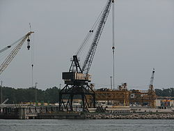 Cape Charles was, for many years, the terminal for the Little Creek-Cape Charles Ferry, providing passenger and car ferry service across the bay to Norfolk and Hampton. The last ferry left Cape Charles in 1953. Cape Charles still serves as a terminal for railway barges that carry rail cars from the former Eastern Shore Railroad
which is now Bay Coast Railroad
across the mouth of the Bay to Norfolk.
The town hosted the Northampton Red Sox in the old Eastern Shore Baseball League
.
Northampton County, Virginia
As of the census of 2010, there were 12,389 people, 5,321 households, and 3,543 families residing in the county. The population density was 63 people per square mile . There were 6,547 housing units at an average density of 32 per square mile...
, Virginia
Virginia
The Commonwealth of Virginia , is a U.S. state on the Atlantic Coast of the Southern United States. Virginia is nicknamed the "Old Dominion" and sometimes the "Mother of Presidents" after the eight U.S. presidents born there...
, United States
United States
The United States of America is a federal constitutional republic comprising fifty states and a federal district...
. The population was 1,134 at the 2000 census.
Geography
Cape Charles is located at 37.267522°N 76.014125°W (37.267522, -76.014125).According to the United States Census Bureau
United States Census Bureau
The United States Census Bureau is the government agency that is responsible for the United States Census. It also gathers other national demographic and economic data...
, the town has a total area of 4.4 square miles (11.3 km2), of which, 3.7 square miles (9.5 km2) of it is land and 0.7 square miles (1.8 km2) of it (16.06%) is water.
Demographics
As of the censusCensus
A census is the procedure of systematically acquiring and recording information about the members of a given population. It is a regularly occurring and official count of a particular population. The term is used mostly in connection with national population and housing censuses; other common...
of 2000, there were 1,134 people, 536 households, and 278 families residing in the town. The population density
Population density
Population density is a measurement of population per unit area or unit volume. It is frequently applied to living organisms, and particularly to humans...
was 309.4 people per square mile (119.3/km2). There were 740 housing units at an average density of 201.9 per square mile (77.9/km2). The racial makeup of the town was 53.79% White, 42.86% African American, 0.09% Native American, 0.44% Asian, 1.59% from other races
Race (United States Census)
Race and ethnicity in the United States Census, as defined by the Federal Office of Management and Budget and the United States Census Bureau, are self-identification data items in which residents choose the race or races with which they most closely identify, and indicate whether or not they are...
, and 1.23% from two or more races. Hispanic or Latino of any race were 2.82% of the population.
There were 536 households out of which 21.1% had children under the age of 18 living with them, 30.4% were married couples
Marriage
Marriage is a social union or legal contract between people that creates kinship. It is an institution in which interpersonal relationships, usually intimate and sexual, are acknowledged in a variety of ways, depending on the culture or subculture in which it is found...
living together, 19.6% had a female householder with no husband present, and 48.1% were non-families. 43.7% of all households were made up of individuals and 26.3% had someone living alone who was 65 years of age or older. The average household size was 2.11 and the average family size was 2.91.
In the town the population was spread out with 22.1% under the age of 18, 7.1% from 18 to 24, 22.0% from 25 to 44, 25.0% from 45 to 64, and 23.8% who were 65 years of age or older. The median age was 44 years. For every 100 females there were 76.4 males. For every 100 females age 18 and over, there were 75.9 males.
The median income for a household in the town was $22,237, and the median income for a family was $29,167. Males had a median income of $25,536 versus $23,984 for females. The per capita income
Per capita income
Per capita income or income per person is a measure of mean income within an economic aggregate, such as a country or city. It is calculated by taking a measure of all sources of income in the aggregate and dividing it by the total population...
for the town was $13,789. About 21.5% of families and 28.4% of the population were below the poverty line, including 43.4% of those under age 18 and 23.0% of those age 65 or over.
History
Cape Charles, located close to the mouth of the Chesapeake BayChesapeake Bay
The Chesapeake Bay is the largest estuary in the United States. It lies off the Atlantic Ocean, surrounded by Maryland and Virginia. The Chesapeake Bay's drainage basin covers in the District of Columbia and parts of six states: New York, Pennsylvania, Delaware, Maryland, Virginia, and West...
, on Virginia's Eastern Shore
Eastern Shore of Virginia
The Eastern Shore of Virginia consists of two counties on the Atlantic coast of the Commonwealth of Virginia in the United States. The region is part of the Delmarva Peninsula and is separated from the rest of Virginia by the Chesapeake Bay. Its population was 45,553 as of 2010...
, was founded in 1884 as a planned community by railroad and ferry interests. Historian William G. Thomas writes, "At a cost of nearly $300,000, the N.Y., P. & N. was dredging a new harbor out of a large fresh-water lagoon between King’s and Old Plantation creeks in lower Northampton County, and Scott planned to develop a new town around it called Cape Charles City. The appellation “City” for any place on the Eastern Shore was romantic, a vision of the future that the railroad might make possible....In 1890 the Corps of Engineers dredged the harbor basin, its entrance, and a channel through Cherrystone Inlet and built stone jetties protecting the harbor outlet. By 1912 the Corps estimated that Cape Charles harbor handled 2,500,000 tons of freight a year." (See: The Countryside Transformed)
Eastern Shore Railroad
The Eastern Shore Railroad, Inc. was a Class III short-line railroad that began operations in October 1981 on the 96 mile former Virginia and Maryland Railroad line on the Delmarva Peninsula...
which is now Bay Coast Railroad
Bay Coast Railroad
The Bay Coast Railroad operates the former Eastern Shore Railroad line from Pocomoke City, Maryland, to Norfolk, Virginia. The Bay Coast Railroad interchanges with the Norfolk Southern Railway at both Norfolk, Virginia and Pocomoke City, Maryland.-History:...
across the mouth of the Bay to Norfolk.
The town hosted the Northampton Red Sox in the old Eastern Shore Baseball League
Eastern Shore Baseball League
The Eastern Shore Baseball League was a Class D minor league baseball league that operated on the Delmarva Peninsula for parts of three different decades. The league's first season was in 1922 and the last was in 1949, although the years were not consecutive, and featured teams from Maryland,...
.
External links
- Cape Charles, Virginia Guide
- Cape Charles in photos
- Cape Charles & Chesapeake Bay Live Webcam
- Wilson's Building Condominiums, Cape Charles
- Will Thomas, The Countryside Transformed: The Eastern Shore of Virginia, the Pennsylvania Railroad, and the Creation of a Modern Landscape, Southern Spaces, 31 July 2007.
- Cape Charles Municipal Website
- Bay Creek Resort & Club Website
- Northampton County Chamber of Commerce Website