

Kent Island, Maryland
Encyclopedia
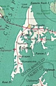
Kent Island is the largest island
in the Chesapeake Bay
, and a historic place in Maryland
. To the east, a narrow channel known as the Kent Narrows
barely separates the island from the Delmarva Peninsula
, and on the other side, the island is separated from Sandy Point, an area near Annapolis
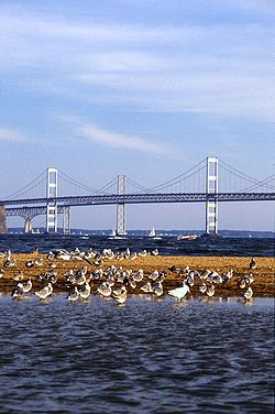
, by roughly four miles (6.4 km) of water. At only four miles wide, the main waterway of the bay is at its narrowest at this point and is spanned here by the Chesapeake Bay Bridge
. The Chester River
runs to the north of the island and empties into the Chesapeake Bay at Kent Island's Love Point
. To the south of the island lies Eastern Bay
. The United States Census Bureau
reports that the island has 31.62 square mile of land area.
Kent Island is part of Queen Anne's County, Maryland
and Maryland's Eastern Shore region. The first English
establishment on the island, Kent Fort
, was founded in 1631, making Kent Island the oldest English settlement within the present day state of Maryland, and the third oldest permanent English settlement in the United States
, after Jamestown, Virginia
and Plymouth, Massachusetts. The census-designated place
s of Stevensville
, and Chester
are located on the island, along with several other communities, including the fishing community of Kent Narrows
, which is located partially on the island. Although all of Kent Island's communities are unincorporated
, the census designated places
of Stevensville
and Chester
on the island are both more populous than any of Queen Anne's County's incorporated towns.
, the island was inhabited by the Matapeake tribe, members of the Algonquian
nation who the Matapeake
area of Kent Island is named after. Other tribes that inhabited the area and often visited the island included the Ozinie and Monoponson tribes, the latter of which share their name with the Algonquian
name for the island, Monoponson. During the 16th and 17th centuries, early explorers of the Chesapeake Bay, including Captain John Smith
, were the first Europe
ans to see Kent Island; however, it wasn't until August of 1631 that the island became an English settlement. At that time, William Claiborne
, a resident of Jamestown, founded a settlement near the southern end of the island for the purpose of trading with Native Americans
, and named the island after his birthplace of Kent
, England
. The settlement burned down in the winter of 1631-32, but was quickly rebuilt, and in 1634 the settlement included a gristmill, courthouse, and trading station. Following the formation of the province of Maryland
, Claiborne continued to recognize the island as part of his home colony of Virginia while Cecilius Calvert, 2nd Baron Baltimore
recognized it as part of Maryland. Claiborne was forced from, and returned to the island twice before leaving permanently in 1658, thus effectively ending the disputes. Virginia's official claims to the island, however, continued until 1776.
and corn, however that ended due to the depletion of nutrient rich soil as a result of the lack of crop rotation and poor farming practices. The island's economy went into decline while the soil recovered, with the exception of the port town of Broad Creek
. This began to change around the time of the Industrial Revolution
. In 1850, the town of Stevensville
was founded after the sale of farms owned by James and Charles Stevens, and prospered as a major hub for steamboat travel across the Chesapeake Bay. Stevensville was also the home of a railroad station, known as the Stevensville Train Depot, that was located near the western end of a railroad that carried ferry
passengers to other parts of the Eastern Shore. Also during this time, small resorts on the shores of the Chesapeake Bay and the Atlantic Ocean
became common in the area. Such a resort existed at Love Point, to the north of Stevensville. Farming returned to the economy in the nineteenth and twentieth centuries with farmers growing crops including corn, wheat, berries, and melons. Many of the island's inhabitants worked as watermen in the expanding seafood industry capitalizing on the Chesapeake's supply of Maryland Blue Crab, Rockfish, and oysters.
. The bridge completely replaced the steamboat system and also led to further growth of Kent Island and the rest of the Eastern Shore. In 1973, In order to accommodate growing traffic across the bay, the bridge was expanded with an additional span built next to the existing one. Then, in the late 1980s and early 1990s U.S. Route 50
was converted to a freeway across the island.
. Local businesses and historic local landmarks were either damaged or destroyed in the storm and the storm surge
caused by it. Much of the damage from the hurricane, mostly caused by flooding, took several months to repair.
Today, Kent Island is considered a suburb
of the Baltimore-Washington Metropolitan Area
and was home to 16,812 residents at the time of the 2000 U.S. Census
. The combined area of the Stevensville and Chester CDPs had 9,603 residents. Many have relocated from the Washington, D.C.
or Baltimore
metro areas and continue to commute back there. Stevensville and Chester are also among the most densely populated
areas of the Eastern Shore, and the most densely populated in Queen Anne's County, making up 23.67% of its population and only 3.07% of its land area.
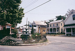
 As of 2006, many of the island's historic places have been preserved and are highlighted by the Chesapeake Country Scenic Byway
and the American Discovery Trail
, both of which pass through the island. Several buildings on the island that are still left over from the 19th century and earlier include the Cray House, a rare remaining example of post and plank construction, the old Stevensville post office (left, yellow building in center), Christ Episcopal Church, and the Stevensville Train Depot (right). Stevensville's historic district
along with some of the buildings in the town are on the National Register of Historic Places
.
/U.S. Route 301
freeway, which connects the Island to Central Maryland via the Chesapeake Bay Bridge
and to the Delmarva Peninsula
via the Kent Narrows Bridge. The island is also served by Maryland Routes 8
, 18
, and 552
.
, a walking and biking trail
on Kent Island, was built in the late 1990s, as part of Queen Anne's County's portion of the American Discovery Trail
. The full trail was completed in 2001.
By the time the Cross Island Trail was completed, growing concern over the safety of pedestrians using the shoulder of Route 8 prompted the construction of a new trail paralleling the road. When completed, the trail, known as the Kent Island South Trail, will run from Romancoke
Pier at the southern end of Route 8, heading north and crossing the road in Matapeake
, near Matapeake Elementary and Middle Schools. From there it will pass through Mobray Park, then over US 50, through Stevensville and will end at the Cross Island Trail in or near Old Love Point Park.
Both the Cross Island and Kent Island South Trails are part of a planned trail system for Queen Anne's County, the entire Cross Island Trail and the existing section of the Kent Island South Trail represent the only completed portions of the system.
 The bridge
s that currently connect Kent Island to the mainland, or once did, are as follows:
Local airports on the island serve as another type of connection to the mainland. The largest is the Bay Bridge Airport
, located near the Chesapeake Bay Bridge. Before the construction of the Bay Bridge, ferry
services connected the island directly to Baltimore, Annapolis, and the small peninsula
on which St. Michaels
is located. Some of the piers that were used as part of the ferry service are still used for fishing.
Island
An island or isle is any piece of sub-continental land that is surrounded by water. Very small islands such as emergent land features on atolls can be called islets, cays or keys. An island in a river or lake may be called an eyot , or holm...
in the Chesapeake Bay
Chesapeake Bay
The Chesapeake Bay is the largest estuary in the United States. It lies off the Atlantic Ocean, surrounded by Maryland and Virginia. The Chesapeake Bay's drainage basin covers in the District of Columbia and parts of six states: New York, Pennsylvania, Delaware, Maryland, Virginia, and West...
, and a historic place in Maryland
Maryland
Maryland is a U.S. state located in the Mid Atlantic region of the United States, bordering Virginia, West Virginia, and the District of Columbia to its south and west; Pennsylvania to its north; and Delaware to its east...
. To the east, a narrow channel known as the Kent Narrows
Kent Narrows
The Kent Narrows, also known as Kent Island Narrows and to local residents simply as the Narrows, is a waterway that connects the Chester River with the Eastern Bay and also separates Kent Island from the Delmarva Peninsula. It runs through the community of Kent Narrows, Maryland. The Kent...
barely separates the island from the Delmarva Peninsula
Delmarva Peninsula
The Delmarva Peninsula is a large peninsula on the East Coast of the United States, occupied by most of Delaware and portions of Maryland and Virginia...
, and on the other side, the island is separated from Sandy Point, an area near Annapolis
Annapolis, Maryland
Annapolis is the capital of the U.S. state of Maryland, as well as the county seat of Anne Arundel County. It had a population of 38,394 at the 2010 census and is situated on the Chesapeake Bay at the mouth of the Severn River, south of Baltimore and about east of Washington, D.C. Annapolis is...
, by roughly four miles (6.4 km) of water. At only four miles wide, the main waterway of the bay is at its narrowest at this point and is spanned here by the Chesapeake Bay Bridge
Chesapeake Bay Bridge
The Chesapeake Bay Bridge is a major dual-span bridge in the U.S. state of Maryland. Spanning the Chesapeake Bay, it connects the state's rural Eastern Shore region with the more urban Western Shore. The original span opened in 1952 and, at the time, with a length of , it was the world's longest...
. The Chester River
Chester River
The Chester River is a major tributary of the Chesapeake Bay on the Delmarva Peninsula. It is about long, and its watershed encompasses , which includes of land. Thus the total watershed area is 20% water. It forms the border between Kent County and Queen Anne's County, Maryland, with its...
runs to the north of the island and empties into the Chesapeake Bay at Kent Island's Love Point
Love Point, Maryland
Love Point is the name for the northernmost tip of Kent Island, and as such, marks the southern point of the mouth of the Chester River. It has served as a major ferry terminal, the western terminus of the Queen Anne's Railroad, and the nominal western terminus of Maryland Route 18...
. To the south of the island lies Eastern Bay
Eastern Bay
The Eastern Bay is a tributary of the Chesapeake Bay located between Queen Anne's County, Maryland and Talbot County, Maryland on the Eastern Shore. Its main tributaries include the Miles River and the Wye River...
. The United States Census Bureau
United States Census Bureau
The United States Census Bureau is the government agency that is responsible for the United States Census. It also gathers other national demographic and economic data...
reports that the island has 31.62 square mile of land area.
Kent Island is part of Queen Anne's County, Maryland
Queen Anne's County, Maryland
Queen Anne's County is a county located on the Eastern Shore of the U.S. state of Maryland.As of 2010, the population was 47,798. Its county seat and most populous municipality is Centreville. The census-designated place of Stevensville is the county's most populous place...
and Maryland's Eastern Shore region. The first English
England
England is a country that is part of the United Kingdom. It shares land borders with Scotland to the north and Wales to the west; the Irish Sea is to the north west, the Celtic Sea to the south west, with the North Sea to the east and the English Channel to the south separating it from continental...
establishment on the island, Kent Fort
Kent Fort, Maryland
Kent Fort was a fort and settlement located near on southern Kent Island in colonial Virginia and later Maryland, and was the first English settlement within the boundaries of present-day Maryland and the third oldest permanent English settlement in the United States, after Jamestown, Virginia ...
, was founded in 1631, making Kent Island the oldest English settlement within the present day state of Maryland, and the third oldest permanent English settlement in the United States
United States
The United States of America is a federal constitutional republic comprising fifty states and a federal district...
, after Jamestown, Virginia
Jamestown, Virginia
Jamestown was a settlement in the Colony of Virginia. Established by the Virginia Company of London as "James Fort" on May 14, 1607 , it was the first permanent English settlement in what is now the United States, following several earlier failed attempts, including the Lost Colony of Roanoke...
and Plymouth, Massachusetts. The census-designated place
Census-designated place
A census-designated place is a concentration of population identified by the United States Census Bureau for statistical purposes. CDPs are delineated for each decennial census as the statistical counterparts of incorporated places such as cities, towns and villages...
s of Stevensville
Stevensville, Maryland
Stevensville is a census-designated place in Queen Anne's County, Maryland, and is the county's most populous place among both CDPs and municipalities. The Stevensville Historic District is one of only two registered historic districts in the county, the other being the Centreville Historic...
, and Chester
Chester, Maryland
Chester is a census-designated place on Kent Island in Queen Anne's County, Maryland, United States. The population was 3,723 at the 2000 census.-Geography:Chester is located at ....
are located on the island, along with several other communities, including the fishing community of Kent Narrows
Kent Narrows, Maryland
Kent Narrows is a census-designated place and town in Queen Anne's County, Maryland, United States. As of the 2000 census, the town had a population of 567.-Geography:Kent Narrows is located at ....
, which is located partially on the island. Although all of Kent Island's communities are unincorporated
Unincorporated area
In law, an unincorporated area is a region of land that is not a part of any municipality.To "incorporate" in this context means to form a municipal corporation, a city, town, or village with its own government. An unincorporated community is usually not subject to or taxed by a municipal government...
, the census designated places
Census-designated place
A census-designated place is a concentration of population identified by the United States Census Bureau for statistical purposes. CDPs are delineated for each decennial census as the statistical counterparts of incorporated places such as cities, towns and villages...
of Stevensville
Stevensville, Maryland
Stevensville is a census-designated place in Queen Anne's County, Maryland, and is the county's most populous place among both CDPs and municipalities. The Stevensville Historic District is one of only two registered historic districts in the county, the other being the Centreville Historic...
and Chester
Chester, Maryland
Chester is a census-designated place on Kent Island in Queen Anne's County, Maryland, United States. The population was 3,723 at the 2000 census.-Geography:Chester is located at ....
on the island are both more populous than any of Queen Anne's County's incorporated towns.
Early and Colonial
Prior to European colonizationEuropean colonization of the Americas
The start of the European colonization of the Americas is typically dated to 1492. The first Europeans to reach the Americas were the Vikings during the 11th century, who established several colonies in Greenland and one short-lived settlement in present day Newfoundland...
, the island was inhabited by the Matapeake tribe, members of the Algonquian
Algonquian peoples
The Algonquian are one of the most populous and widespread North American native language groups, with tribes originally numbering in the hundreds. Today hundreds of thousands of individuals identify with various Algonquian peoples...
nation who the Matapeake
Matapeake, Maryland
Matapeake is an unincorporated community located south of Stevensville on Kent Island, Maryland.It is named for the historic Matapeake Indian tribe, who lived there at the time of English colonization in 1631. Their chief village was on the southeast side of the island...
area of Kent Island is named after. Other tribes that inhabited the area and often visited the island included the Ozinie and Monoponson tribes, the latter of which share their name with the Algonquian
Algonquian languages
The Algonquian languages also Algonkian) are a subfamily of Native American languages which includes most of the languages in the Algic language family. The name of the Algonquian language family is distinguished from the orthographically similar Algonquin dialect of the Ojibwe language, which is a...
name for the island, Monoponson. During the 16th and 17th centuries, early explorers of the Chesapeake Bay, including Captain John Smith
John Smith of Jamestown
Captain John Smith Admiral of New England was an English soldier, explorer, and author. He was knighted for his services to Sigismund Bathory, Prince of Transylvania and friend Mózes Székely...
, were the first Europe
Europe
Europe is, by convention, one of the world's seven continents. Comprising the westernmost peninsula of Eurasia, Europe is generally 'divided' from Asia to its east by the watershed divides of the Ural and Caucasus Mountains, the Ural River, the Caspian and Black Seas, and the waterways connecting...
ans to see Kent Island; however, it wasn't until August of 1631 that the island became an English settlement. At that time, William Claiborne
William Claiborne
William Claiborne was an English pioneer, surveyor, and an early settler in Virginia and Maryland. Claiborne became a wealthy planter, a trader, and a major figure in the politics of the colony...
, a resident of Jamestown, founded a settlement near the southern end of the island for the purpose of trading with Native Americans
Native Americans in the United States
Native Americans in the United States are the indigenous peoples in North America within the boundaries of the present-day continental United States, parts of Alaska, and the island state of Hawaii. They are composed of numerous, distinct tribes, states, and ethnic groups, many of which survive as...
, and named the island after his birthplace of Kent
Kent
Kent is a county in southeast England, and is one of the home counties. It borders East Sussex, Surrey and Greater London and has a defined boundary with Essex in the middle of the Thames Estuary. The ceremonial county boundaries of Kent include the shire county of Kent and the unitary borough of...
, England
England
England is a country that is part of the United Kingdom. It shares land borders with Scotland to the north and Wales to the west; the Irish Sea is to the north west, the Celtic Sea to the south west, with the North Sea to the east and the English Channel to the south separating it from continental...
. The settlement burned down in the winter of 1631-32, but was quickly rebuilt, and in 1634 the settlement included a gristmill, courthouse, and trading station. Following the formation of the province of Maryland
Province of Maryland
The Province of Maryland was an English and later British colony in North America that existed from 1632 until 1776, when it joined the other twelve of the Thirteen Colonies in rebellion against Great Britain and became the U.S...
, Claiborne continued to recognize the island as part of his home colony of Virginia while Cecilius Calvert, 2nd Baron Baltimore
Cecilius Calvert, 2nd Baron Baltimore
Cecilius Calvert, 2nd Baron Baltimore, 1st Proprietor and 1st Proprietary Governor of Maryland, 9th Proprietary Governor of Newfoundland , was an English peer who was the first proprietor of the Province of Maryland. He received the proprietorship after the death of his father, George Calvert, the...
recognized it as part of Maryland. Claiborne was forced from, and returned to the island twice before leaving permanently in 1658, thus effectively ending the disputes. Virginia's official claims to the island, however, continued until 1776.
Industrial Revolution
Until the early 19th century, Kent Island was used almost entirely for farming of tobaccoTobacco
Tobacco is an agricultural product processed from the leaves of plants in the genus Nicotiana. It can be consumed, used as a pesticide and, in the form of nicotine tartrate, used in some medicines...
and corn, however that ended due to the depletion of nutrient rich soil as a result of the lack of crop rotation and poor farming practices. The island's economy went into decline while the soil recovered, with the exception of the port town of Broad Creek
Broad Creek, Maryland
Broad Creek was a town on western Kent Island, Maryland that existed from the 17th century to the 19th century. The town once served as the eastern terminus of a trans-Chesapeake Bay ferry line that was part of an early route between Annapolis and Philadelphia.In the mid 19th century, with the...
. This began to change around the time of the Industrial Revolution
Industrial Revolution
The Industrial Revolution was a period from the 18th to the 19th century where major changes in agriculture, manufacturing, mining, transportation, and technology had a profound effect on the social, economic and cultural conditions of the times...
. In 1850, the town of Stevensville
Stevensville, Maryland
Stevensville is a census-designated place in Queen Anne's County, Maryland, and is the county's most populous place among both CDPs and municipalities. The Stevensville Historic District is one of only two registered historic districts in the county, the other being the Centreville Historic...
was founded after the sale of farms owned by James and Charles Stevens, and prospered as a major hub for steamboat travel across the Chesapeake Bay. Stevensville was also the home of a railroad station, known as the Stevensville Train Depot, that was located near the western end of a railroad that carried ferry
Ferry
A ferry is a form of transportation, usually a boat, but sometimes a ship, used to carry primarily passengers, and sometimes vehicles and cargo as well, across a body of water. Most ferries operate on regular, frequent, return services...
passengers to other parts of the Eastern Shore. Also during this time, small resorts on the shores of the Chesapeake Bay and the Atlantic Ocean
Atlantic Ocean
The Atlantic Ocean is the second-largest of the world's oceanic divisions. With a total area of about , it covers approximately 20% of the Earth's surface and about 26% of its water surface area...
became common in the area. Such a resort existed at Love Point, to the north of Stevensville. Farming returned to the economy in the nineteenth and twentieth centuries with farmers growing crops including corn, wheat, berries, and melons. Many of the island's inhabitants worked as watermen in the expanding seafood industry capitalizing on the Chesapeake's supply of Maryland Blue Crab, Rockfish, and oysters.
Twentieth century
As roads replaced railroads and steamboats into the 20th century, there was a growing need for a road bridge connecting the two shores of the Chesapeake Bay. In 1952 the Chesapeake Bay Bridge was completed, connecting the island directly to the Baltimore-Washington Metropolitan AreaBaltimore-Washington Metropolitan Area
The Baltimore-Washington Metropolitan Area is a combined statistical area consisting of the overlapping labor market region of the cities of Baltimore, Maryland and Washington, D.C.. The region includes Central Maryland, Northern Virginia, and Jefferson County in the Eastern Panhandle of West...
. The bridge completely replaced the steamboat system and also led to further growth of Kent Island and the rest of the Eastern Shore. In 1973, In order to accommodate growing traffic across the bay, the bridge was expanded with an additional span built next to the existing one. Then, in the late 1980s and early 1990s U.S. Route 50
U.S. Route 50
U.S. Route 50 is a major east–west route of the U.S. Highway system, stretching just over from Ocean City, Maryland on the Atlantic Ocean to West Sacramento, California. Until 1972, when it was replaced by Interstate Highways west of the Sacramento area, it extended to San Francisco, near...
was converted to a freeway across the island.
Recent history
In September 2003, Kent Island was one of the many places in the Chesapeake Bay Area affected by Hurricane IsabelHurricane Isabel
Hurricane Isabel was the costliest and deadliest hurricane in the 2003 Atlantic hurricane season. The ninth named storm, fifth hurricane, and second major hurricane of the season, Isabel formed near the Cape Verde Islands from a tropical wave on September 6 in the tropical Atlantic Ocean...
. Local businesses and historic local landmarks were either damaged or destroyed in the storm and the storm surge
Storm surge
A storm surge is an offshore rise of water associated with a low pressure weather system, typically tropical cyclones and strong extratropical cyclones. Storm surges are caused primarily by high winds pushing on the ocean's surface. The wind causes the water to pile up higher than the ordinary sea...
caused by it. Much of the damage from the hurricane, mostly caused by flooding, took several months to repair.
Today, Kent Island is considered a suburb
Suburb
The word suburb mostly refers to a residential area, either existing as part of a city or as a separate residential community within commuting distance of a city . Some suburbs have a degree of administrative autonomy, and most have lower population density than inner city neighborhoods...
of the Baltimore-Washington Metropolitan Area
Baltimore-Washington Metropolitan Area
The Baltimore-Washington Metropolitan Area is a combined statistical area consisting of the overlapping labor market region of the cities of Baltimore, Maryland and Washington, D.C.. The region includes Central Maryland, Northern Virginia, and Jefferson County in the Eastern Panhandle of West...
and was home to 16,812 residents at the time of the 2000 U.S. Census
United States Census, 2000
The Twenty-second United States Census, known as Census 2000 and conducted by the Census Bureau, determined the resident population of the United States on April 1, 2000, to be 281,421,906, an increase of 13.2% over the 248,709,873 persons enumerated during the 1990 Census...
. The combined area of the Stevensville and Chester CDPs had 9,603 residents. Many have relocated from the Washington, D.C.
Washington, D.C.
Washington, D.C., formally the District of Columbia and commonly referred to as Washington, "the District", or simply D.C., is the capital of the United States. On July 16, 1790, the United States Congress approved the creation of a permanent national capital as permitted by the U.S. Constitution....
or Baltimore
Baltimore
Baltimore is the largest independent city in the United States and the largest city and cultural center of the US state of Maryland. The city is located in central Maryland along the tidal portion of the Patapsco River, an arm of the Chesapeake Bay. Baltimore is sometimes referred to as Baltimore...
metro areas and continue to commute back there. Stevensville and Chester are also among the most densely populated
Population density
Population density is a measurement of population per unit area or unit volume. It is frequently applied to living organisms, and particularly to humans...
areas of the Eastern Shore, and the most densely populated in Queen Anne's County, making up 23.67% of its population and only 3.07% of its land area.
Historic places
Chesapeake Country Scenic Byway
The Chesapeake Country Scenic Byway is a national scenic byway on Maryland's Eastern Shore region. The byway runs from Stevensville, near the Chesapeake Bay Bridge to the Chesapeake and Delaware Canal in Chesapeake City and has a spur to Eastern Neck Island in the Chester River...
and the American Discovery Trail
American Discovery Trail
The American Discovery Trail is a coast-to-coast hiking and biking trail across the mid-tier of the United States. It starts on the Delmarva Peninsula on the Atlantic Ocean and ends on the northern California coast on the Pacific Ocean, and is signed on over of trail. This includes the doubled...
, both of which pass through the island. Several buildings on the island that are still left over from the 19th century and earlier include the Cray House, a rare remaining example of post and plank construction, the old Stevensville post office (left, yellow building in center), Christ Episcopal Church, and the Stevensville Train Depot (right). Stevensville's historic district
Stevensville Historic District
The Stevensville Historic District, also known as Historic Stevensville, is a national historic district in downtown Stevensville, Queen Anne's County, Maryland. It contains roughly 100 historic structures, and is listed on the National Register of Historic Places...
along with some of the buildings in the town are on the National Register of Historic Places
National Register of Historic Places
The National Register of Historic Places is the United States government's official list of districts, sites, buildings, structures, and objects deemed worthy of preservation...
.
Notable residents
Listed are notable people who have lived on Kent Island.- Brock AdamsBrock AdamsBrockman "Brock" Adams was an American politician and member of Congress. Adams was a Democrat from Washington and served as a U.S. Representative, Senator, and United States Secretary of Transportation before retiring in January 1993.Adams was born in Atlanta, Georgia, and attended the public...
- United States Secretary of TransportationUnited States Secretary of TransportationThe United States Secretary of Transportation is the head of the United States Department of Transportation, a member of the President's Cabinet, and fourteenth in the Presidential line of succession. The post was created with the formation of the Department of Transportation on October 15, 1966,...
and United States SenatorUnited States SenateThe United States Senate is the upper house of the bicameral legislature of the United States, and together with the United States House of Representatives comprises the United States Congress. The composition and powers of the Senate are established in Article One of the U.S. Constitution. Each...
from Washington - Elbert N. CarvelElbert N. CarvelElbert Nostrand "Bert" Carvel was an American businessman and politician from Laurel, in Sussex County, Delaware...
- Governor of DelawareDelawareDelaware is a U.S. state located on the Atlantic Coast in the Mid-Atlantic region of the United States. It is bordered to the south and west by Maryland, and to the north by Pennsylvania... - William ClaiborneWilliam ClaiborneWilliam Claiborne was an English pioneer, surveyor, and an early settler in Virginia and Maryland. Claiborne became a wealthy planter, a trader, and a major figure in the politics of the colony...
- Founder of Kent Island - James EaricksonJames EaricksonJames Earickson was a U.S. politician from Missouri.James Earickson was born in Isle of Kent, Maryland, and moved to Missouri in 1818. He was elected to the Missouri State Senate in August, 1828. Less than five months later, in January, 1829, he was appointed as State Treasurer of Missouri...
- former State Treasurer of Missouri - Henry R. GibsonHenry R. GibsonHenry Richard Gibson was an American politician and a member of the United States House of Representatives for the 2nd congressional district of Tennessee.-Biography:...
- U.S. representativeUnited States House of RepresentativesThe United States House of Representatives is one of the two Houses of the United States Congress, the bicameral legislature which also includes the Senate.The composition and powers of the House are established in Article One of the Constitution...
from TennesseeTennesseeTennessee is a U.S. state located in the Southeastern United States. It has a population of 6,346,105, making it the nation's 17th-largest state by population, and covers , making it the 36th-largest by total land area... - Theodore N. Lerner - Principal owner of the Washington NationalsWashington NationalsThe Washington Nationals are a professional baseball team based in Washington, D.C. The Nationals are a member of the Eastern Division of the National League of Major League Baseball . The team moved into the newly built Nationals Park in 2008, after playing their first three seasons in RFK Stadium...
- Edward "E.J." Pipkin - Maryland state senatorMaryland State SenateThe Maryland Senate, sometimes referred to as the Maryland State Senate, is the upper house of the General Assembly, the state legislature of the U.S. state of Maryland...
Roads
The main mode of transportation on Kent Island, as with most other suburban areas of the United States, is by car. Kent Island's main roads include the U.S. Route 50U.S. Route 50 in Maryland
U.S. Route 50 is a major east–west route of the U.S. Highway system, stretching just over from Ocean City, Maryland on the Atlantic Ocean to West Sacramento, California. In the U.S. state of Maryland, US 50 exists in two sections. The longer of these serves as a major route connecting...
/U.S. Route 301
U.S. Route 301 in Maryland
U.S. Route 301 in Maryland is a major highway that runs from Delaware to the Governor Harry W. Nice Memorial Bridge into Virginia. It passes through three of Maryland's four main regions: the Eastern Shore, the Baltimore-Washington Metropolitan Area, and Southern Maryland...
freeway, which connects the Island to Central Maryland via the Chesapeake Bay Bridge
Chesapeake Bay Bridge
The Chesapeake Bay Bridge is a major dual-span bridge in the U.S. state of Maryland. Spanning the Chesapeake Bay, it connects the state's rural Eastern Shore region with the more urban Western Shore. The original span opened in 1952 and, at the time, with a length of , it was the world's longest...
and to the Delmarva Peninsula
Delmarva Peninsula
The Delmarva Peninsula is a large peninsula on the East Coast of the United States, occupied by most of Delaware and portions of Maryland and Virginia...
via the Kent Narrows Bridge. The island is also served by Maryland Routes 8
Maryland Route 8
Maryland Route 8 is a state highway in the U.S. state of Maryland. Known for most of its length as Romancoke Road, the state highway runs from Romancoke Pier in Romancoke north to MD 18 in Stevensville. MD 8 is the main north–south highway of Kent Island in western Queen Anne's County. ...
, 18
Maryland Route 18
Maryland Route 18 is a state highway in the U.S. state of Maryland. The state highway runs from the beginning of state maintenance at Love Point east to MD 213 in Centreville...
, and 552
Maryland Route 552
Maryland Route 552 is a state highway in the U.S. state of Maryland. The state highway runs from Dominion north to U.S. Route 50 and US 301 in Chester. MD 552 was constructed south of Maryland Route 18 in the early 1930s...
.
Trails
The original section of the Cross Island TrailCross Island Trail
The Cross Island Trail is a National Recreation Trail in Queen Anne's County, Maryland that traverses the width of Kent Island. It is a rail trail, occupying a section of the abandoned Queen Anne's Railroad corridor. It was built during the late 1990s and early 2000s with the full trail being...
, a walking and biking trail
Trail
A trail is a path with a rough beaten or dirt/stone surface used for travel. Trails may be for use only by walkers and in some places are the main access route to remote settlements...
on Kent Island, was built in the late 1990s, as part of Queen Anne's County's portion of the American Discovery Trail
American Discovery Trail
The American Discovery Trail is a coast-to-coast hiking and biking trail across the mid-tier of the United States. It starts on the Delmarva Peninsula on the Atlantic Ocean and ends on the northern California coast on the Pacific Ocean, and is signed on over of trail. This includes the doubled...
. The full trail was completed in 2001.
By the time the Cross Island Trail was completed, growing concern over the safety of pedestrians using the shoulder of Route 8 prompted the construction of a new trail paralleling the road. When completed, the trail, known as the Kent Island South Trail, will run from Romancoke
Romancoke, Maryland
Romancoke is an unincorporated community on Kent Island in Maryland, located at the southern end of Maryland Route 8. The United States Census Bureau defines an urban cluster for Romancoke, but not a census-designated place...
Pier at the southern end of Route 8, heading north and crossing the road in Matapeake
Matapeake, Maryland
Matapeake is an unincorporated community located south of Stevensville on Kent Island, Maryland.It is named for the historic Matapeake Indian tribe, who lived there at the time of English colonization in 1631. Their chief village was on the southeast side of the island...
, near Matapeake Elementary and Middle Schools. From there it will pass through Mobray Park, then over US 50, through Stevensville and will end at the Cross Island Trail in or near Old Love Point Park.
Both the Cross Island and Kent Island South Trails are part of a planned trail system for Queen Anne's County, the entire Cross Island Trail and the existing section of the Kent Island South Trail represent the only completed portions of the system.
Connections to the Mainland
Bridge
A bridge is a structure built to span physical obstacles such as a body of water, valley, or road, for the purpose of providing passage over the obstacle...
s that currently connect Kent Island to the mainland, or once did, are as follows:
- The Chesapeake Bay BridgeChesapeake Bay BridgeThe Chesapeake Bay Bridge is a major dual-span bridge in the U.S. state of Maryland. Spanning the Chesapeake Bay, it connects the state's rural Eastern Shore region with the more urban Western Shore. The original span opened in 1952 and, at the time, with a length of , it was the world's longest...
, or Bay Bridge, spans the Chesapeake Bay and carries US 50/301 to AnnapolisAnnapolis, MarylandAnnapolis is the capital of the U.S. state of Maryland, as well as the county seat of Anne Arundel County. It had a population of 38,394 at the 2010 census and is situated on the Chesapeake Bay at the mouth of the Severn River, south of Baltimore and about east of Washington, D.C. Annapolis is...
. - The Kent Narrows Bridge spans the Kent Narrows and carries US 50/301 to the Delmarva PeninsulaDelmarva PeninsulaThe Delmarva Peninsula is a large peninsula on the East Coast of the United States, occupied by most of Delaware and portions of Maryland and Virginia...
. - The Old Kent Narrows Bridge, Kent Narrows Drawbridge, or Route 18 Kent Narrows Bridge is a drawbridgeBascule bridgeA bascule bridge is a moveable bridge with a counterweight that continuously balances the span, or "leaf," throughout the entire upward swing in providing clearance for boat traffic....
that carries MD 18 into GrasonvilleGrasonville, MarylandGrasonville is a census-designated place in Queen Anne's County, Maryland, United States. The population was 2,193 at the 2000 census.-Geography:Grasonville is located at ....
. It was the predecessor to the current Kent Narrows Bridge and now serves local traffic. - An even older automobile bridge once ran across the Kent Narrows and was replaced by the current Route 18 Kent Narrows Bridge. Also in the past, railroad bridges over the Kent Narrows connected the Kent Island portion of the Queen Anne's County Railroad to the mainland.
Local airports on the island serve as another type of connection to the mainland. The largest is the Bay Bridge Airport
Bay Bridge Airport
Bay Bridge Airport is a county-owned public-use airport located in Stevensville, Maryland. The airport is named for the nearby Chesapeake Bay Bridge and is mostly used for general aviation....
, located near the Chesapeake Bay Bridge. Before the construction of the Bay Bridge, ferry
Ferry
A ferry is a form of transportation, usually a boat, but sometimes a ship, used to carry primarily passengers, and sometimes vehicles and cargo as well, across a body of water. Most ferries operate on regular, frequent, return services...
services connected the island directly to Baltimore, Annapolis, and the small peninsula
Peninsula
A peninsula is a piece of land that is bordered by water on three sides but connected to mainland. In many Germanic and Celtic languages and also in Baltic, Slavic and Hungarian, peninsulas are called "half-islands"....
on which St. Michaels
St. Michaels, Maryland
Saint Michaels is a town in Talbot County, Maryland, United States. The population was 1,193 at the 2000 census. Saint Michaels derives its name from the Episcopal Parish established here in 1677...
is located. Some of the piers that were used as part of the ferry service are still used for fishing.
See also
- List of islands in Maryland
- Kent Island High SchoolKent Island High SchoolKent Island High School is a public high school in Stevensville, Maryland that first opened in 1998 to accommodate the growing population of Queen Anne's County...
- The Kent Island Bay TimesThe Kent Island Bay TimesThe Kent Island Bay Times or simply the Bay Times is a weekly newspaper based in Stevensville, Maryland and is owned by Chesapeake Publishing, the same company that owns The Record Observer in Centreville, Maryland and The Star Democrat in Easton, Maryland, and other newspapers on both sides of the...
General information
- Live Video Rt 50 / Rt 8 Bridge
- Live Video Rt 50 Kent Narrows
- Information from the Maryland Online Encyclopedia
- Kent Island Online Kent Island Online - A guide to Kent Island aimed at both locals and touristsTourismTourism is travel for recreational, leisure or business purposes. The World Tourism Organization defines tourists as people "traveling to and staying in places outside their usual environment for not more than one consecutive year for leisure, business and other purposes".Tourism has become a...
- Travel guide from Wikitravel
- Cross Island Trail
- Kent Island Annual Festival Island Bay Day