
Bell Canyon
Encyclopedia
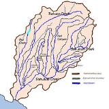
Bell Canyon is a gorge in the Santa Ana Mountains
, its stream flowing about 14.4 miles (23.2 km) to its confluence with San Juan Creek
, in Orange County
of the U.S. state
of California
. A generally south-flowing watercourse, it cuts through a narrow canyon bordered by the watersheds of Cañada Gobernadora
and Trabuco Creek
. After Trabuco Creek, it is the second largest tributary of San Juan Creek by length and drainage area.
Flowing in an arid and wild mountain canyon more than 1000 feet (304.8 m) deep in many parts, the Bell Canyon Creek watershed includes the major tributaries of Dove Canyon, Crow Canyon and Tick Creek and is mostly unincorporated
land. It drains a roughly inverted-"L" shaped area in the mid-eastern portion of the San Juan watershed covering approximately 26 mi2. Most of the creek is now contained within the Cleveland National Forest
and Caspers Regional Park.
or Acagchemem Native Americans
have lived in the Bell Canyon area for almost 10,000 years, from archeology at the San Dieguito Complex. It is said they would strike rocks against boulders in the canyon, producing a ringing sound that gave the canyon its name. The Native Americans, part of the Acjachemen Nation, found their way of life disrupted when Spanish
colonizers and missionaries
came to this area of Las Californias
Province and established the Mission San Juan Capistrano
in 1776 at nearby present day San Juan Capistrano
, about 10 miles (16.1 km) from the creek's mouth.
In 1841, during secularization, Pío Pico
and Andrés Pico
were granted 89,742-acre (363.17 km2) 'Rancho San Onofre y Santa Margarita' next to the Mission San Juan Capistrano by the Mexican Governor of Alta California
, Juan Alvarado. Three years later, the grant of Rancho Las Flores was added, and the grant renamed Rancho Santa Margarita y Las Flores
which included Bell Canyon and Creek. Much of Bell Canyon was purchased by Eugene Grant Starr in the late 1920s, creating a large parcel of undeveloped land that became the National Audubon Society
's 'Starr Ranch' in 1973.
Now a wide and braided watercourse
flowing through an alluvial
valley, Bell Canyon Creek remains much like its original state before the Spanish arrival, although in recent years, it has seen the introduction of urban runoff
, which although does not reach San Juan Creek in the form of surface water, but pollutes groundwater
in the Bell Canyon watershed. Work was begun in 2005 to remove polluted water from two Bell Canyon tributaries that flow through residential areas on the west side of the watershed.
, 8 miles (12.9 km) from the city of Rancho Santa Margarita
, and flows 5.5 miles (8.9 km) westwards and a further 10 miles (16.1 km) southwards to join San Juan Creek 7.5 miles (12.1 km) east of the city of San Juan Capistrano. It receives runoff from about three major tributaries and drains a long, narrow strip of mountainous land that ranges in elevation from 113 feet (34.4 m) at the mouth to 4000 feet (1,219.2 m) at the headwaters.
A fan-shaped network of canyons eroded into the west side of Los Pinos Peak forms the headwaters of Bell Canyon Creek, which lie just a few miles south of Trabuco Creek
's headwaters and a few miles north of the headwaters of Hot Springs Creek, another San Juan Creek tributary. Bell Creek flows through a 1.5 miles (2.4 km)-wide, 1200 feet (365.8 m)-deep canyon for 4 miles (6.4 km) before turning southwest for about 1.5 miles (2.4 km). Narrowly following the city limits of Rancho Santa Margarita which lies to the west, an unnamed tributary enters from the right at river mile
(RM) 10, or river kilometer (RK) 16.1, carrying a small amount of runoff from a residential area on the east side of the city. Bell Canyon then turns southwards and Fox Creek, a slightly larger canyon, enters from the left at RM 9.2 (RK 14.8).
Dove Canyon, the largest tributary of Bell Canyon Creek, draining a 3 miles (4.8 km)-long strip of land that includes residential areas and a golf course
, enters from the right at RM 9 (RK 14.5) and Tick Creek enters in quick succession at RM 8.9 (RK 14.3). The creek then trends southwards through a widening and shallowing valley for some 4 miles (6.4 km) before Crow Canyon enters from the left at RM 4.5 (RK 7.2). By this time Bell Canyon is a wide, meandering braided stream
whose flow is mostly subsurface. When the creek reaches San Juan Creek, it joins on the right bank, directly before Verdugo Canyon Creek enters on the left bank. Below the confluence with Bell Canyon, San Juan Creek flows 14.7 miles (23.7 km) further before emptying into the Pacific Ocean
at Dana Point
.
-age igneous and metamorphic rock
overlain by a few thousand feet of easily erodible Cretaceous
-age sedimentary rock
covered by a thin layer of rocky soil.
The mountains began rising during the late Miocene
epoch, beginning about 5.5 million years ago. The valley floor of the upper Bell Canyon area is underlain by the Bedford Canyon Formation, which is composed of siltstone
, argillite
, conglomerate
, limestone
, slate
and greywacke
.
Two minor seismic faults cross Bell Creek within 4.8 miles (7.7 km) of each other: the Aliso Fault and Mission Viejo Fault, upstream of the Dove Canyon confluence.
The alluvial floodplain
that lines much of the lower canyon today is largely a result of the Wisconsinian glaciation, which forced sea level
worldwide to drop up to 400 feet (121.9 m) from their previous level in the Sangamon interglacial era. This coincided with a massive North America
n climate change that shifted the cold, rainy climate of the Pacific Northwest
further south to Southern California. Rainfall exceeding 80 inches (203.2 cm) per year changed the slow-moving streams of the South Coast to powerful rivers that eroded deep channels into their floodplain
s to maintain equilibrium with the dropping sea level.
The Wisconsinian era lasted from 70,000 to 10,000 years ago, and by the end of that period, climate changed to its present state and Southern California rivers reverted to small seasonal streams. The end of the Wisconsinian also marked the rise of sea level about 300 feet (91.4 m) to its present-day level. The canyons carved by the rivers became long narrow inlets which gradually filled with sediments, but the difference in sea level between the pre-Wisconsinian and post-Wisconsinian was responsible for the formation of river terraces along most streams with a floodplain.
and San Diego County
. It is about 10 miles (16.1 km) long as the crow flies
and about 2 miles (3.2 km) wide at its broadest. Nearly the entire watershed consists of the continuous Bell Canyon valley that ranges from 2600 feet (792.5 m) deep near the headwaters to just 300 feet (91.4 m) deep near the mouth. It covers about 26 mi2, or about 19.42% of the 133.9 mi2 San Juan Creek watershed as a whole.
After the 27 miles (43.5 km) Trabuco Creek
, Bell Canyon Creek is also the second largest tributary within the watershed by terms of length and drainage area. The whole Bell Canyon Creek watershed is enveloped by different drainage areas within the San Juan Creek watershed. On the southeast side are Cold Springs and Hot Springs Creek, tributaries of San Juan Creek above Bell Canyon Creek; on the northwest, Trabuco Creek, on the west, Cañada Gobernadora
. Most of the Bell Canyon drainage area lies within the Cleveland National Forest
in the upper half and the Ronald W. Caspers Regional Park (often abbreviated to Caspers Regional Park or Caspers Park) in the lower half. Dove Canyon, however, is on residential land in the city of Rancho Santa Margarita.
percolation. On mountainous slopes, which comprise about 65% of the watershed, the percolation rate is relatively low and produces a moderate amount of runoff during storms. On the deep alluvium of the valley floors, however, water soaks into the ground and flows subsurface into San Juan Creek. This area is the site of a thick riparian zone
and produces little storm runoff. The third area is the residential areas of Dove Canyon and Tick Creek, in which 90% of the surface water flows into the streams as runoff, and during storms, runoff peaks sharply and diminishes rapidly. This source of urban runoff
is a continuing problem for the Bell Canyon watershed.
and understory
that extends from canyon wall to canyon wall. This riparian area consists of plentiful undergrowth bordering and near the stream, and many trees including the California Sycamore (Platanus racemosa), Fremont Cottonwood
(Populus fremontii), and Coast live oak (Quercus agrifolia). However, non-native invasive species
of plants carried into lower Bell Canyon Creek from its tributaries, such as Periwinkle
(Vinca major) and Ivy
(Hedera spp.), are replacing the California native plant
subshrubs, bunchgrasses, perennials, bulbs, annuals, and groundcovers.
riparian habitat
and provided extra inflow for non-native invasive species
(invasive exotics) of plants to grow.
Santa Ana Mountains
The Santa Ana Mountains are a short peninsular mountain range along the coast of Southern California in the United States. They extend for approximately 36 mi southeast of the Los Angeles Basin largely along the border between Orange and Riverside counties.- Geography :The range starts in the...
, its stream flowing about 14.4 miles (23.2 km) to its confluence with San Juan Creek
San Juan Creek
San Juan Creek, also called the San Juan River, is a stream in Orange County, California that consists of a catchment basin encompassing . Its mainstem rises in the Santa Ana Mountains, in the Trabuco Ranger District of the Cleveland National Forest...
, in Orange County
Orange County, California
Orange County is a county in the U.S. state of California. Its county seat is Santa Ana. As of the 2010 census, its population was 3,010,232, up from 2,846,293 at the 2000 census, making it the third most populous county in California, behind Los Angeles County and San Diego County...
of the U.S. state
U.S. state
A U.S. state is any one of the 50 federated states of the United States of America that share sovereignty with the federal government. Because of this shared sovereignty, an American is a citizen both of the federal entity and of his or her state of domicile. Four states use the official title of...
of California
California
California is a state located on the West Coast of the United States. It is by far the most populous U.S. state, and the third-largest by land area...
. A generally south-flowing watercourse, it cuts through a narrow canyon bordered by the watersheds of Cañada Gobernadora
Cañada Gobernadora
Cañada Gobernadora is a tributary to San Juan Creek, about long, in southern Orange County in the U.S. state of California...
and Trabuco Creek
Trabuco Creek
Trabuco Creek is a small river in the U.S. state of California, flowing from the westernmost extreme of Riverside County through Orange County to join San Juan Creek in the city of San Juan Capistrano. long, its watershed covers in southeastern Orange County, including portions of three...
. After Trabuco Creek, it is the second largest tributary of San Juan Creek by length and drainage area.
Flowing in an arid and wild mountain canyon more than 1000 feet (304.8 m) deep in many parts, the Bell Canyon Creek watershed includes the major tributaries of Dove Canyon, Crow Canyon and Tick Creek and is mostly unincorporated
Unincorporated area
In law, an unincorporated area is a region of land that is not a part of any municipality.To "incorporate" in this context means to form a municipal corporation, a city, town, or village with its own government. An unincorporated community is usually not subject to or taxed by a municipal government...
land. It drains a roughly inverted-"L" shaped area in the mid-eastern portion of the San Juan watershed covering approximately 26 mi2. Most of the creek is now contained within the Cleveland National Forest
Cleveland National Forest
Cleveland National Forest encompasses 460,000 acres , mostly of chaparral, with a few riparian areas. A warm dry mediterranean climate prevails over the Forest. It is the southernmost National forest of California. It is administered by the United States Forest Service, a government agency within...
and Caspers Regional Park.
Human history
The JuaneñoJuaneño
The Juaneño or Acagchemem are a Native American group from Southern California. The Juaneño lived in what is now part of Orange and San Diego Counties and received their Spanish name from the priests of the California mission chain due to their proximity to Mission San Juan Capistrano...
or Acagchemem Native Americans
Native Americans in the United States
Native Americans in the United States are the indigenous peoples in North America within the boundaries of the present-day continental United States, parts of Alaska, and the island state of Hawaii. They are composed of numerous, distinct tribes, states, and ethnic groups, many of which survive as...
have lived in the Bell Canyon area for almost 10,000 years, from archeology at the San Dieguito Complex. It is said they would strike rocks against boulders in the canyon, producing a ringing sound that gave the canyon its name. The Native Americans, part of the Acjachemen Nation, found their way of life disrupted when Spanish
Spanish people
The Spanish are citizens of the Kingdom of Spain. Within Spain, there are also a number of vigorous nationalisms and regionalisms, reflecting the country's complex history....
colonizers and missionaries
Spanish colonization of the Americas
Colonial expansion under the Spanish Empire was initiated by the Spanish conquistadores and developed by the Monarchy of Spain through its administrators and missionaries. The motivations for colonial expansion were trade and the spread of the Christian faith through indigenous conversions...
came to this area of Las Californias
Las Californias
The Californias, or in — - was the name given by the Spanish to their northwestern territory of New Spain, comprising the present day states of Baja California and Baja California Sur on the Baja California Peninsula in Mexico; and the present day U.S. state of California in the United States of...
Province and established the Mission San Juan Capistrano
Mission San Juan Capistrano
Mission San Juan Capistrano was a Spanish mission in Southern California, located in present-day San Juan Capistrano. It was founded on All Saints Day November 1, 1776, by Spanish Catholics of the Franciscan Order...
in 1776 at nearby present day San Juan Capistrano
San Juan Capistrano, California
San Juan Capistrano is a city in southern Orange County, California, located approximately southeast of Downtown Santa Ana. The current OMB metropolitan designation for San Juan Capistrano and the Orange County Area is “Santa Ana-Anaheim-Irvine, CA.” The population was 34,593 at the 2010 census,...
, about 10 miles (16.1 km) from the creek's mouth.
In 1841, during secularization, Pío Pico
Pío Pico
Pío de Jesús Pico was the last Governor of Alta California under Mexican rule.-Origins:...
and Andrés Pico
Andrés Pico
Andrés Pico was a Californio who became a successful rancher, served as a military commander during the Mexican-American War; and was elected to the state assembly and senate after California became a state, when he was also commissioned as a brigadier general in the state militia.-Early...
were granted 89,742-acre (363.17 km2) 'Rancho San Onofre y Santa Margarita' next to the Mission San Juan Capistrano by the Mexican Governor of Alta California
Alta California
Alta California was a province and territory in the Viceroyalty of New Spain and later a territory and department in independent Mexico. The territory was created in 1769 out of the northern part of the former province of Las Californias, and consisted of the modern American states of California,...
, Juan Alvarado. Three years later, the grant of Rancho Las Flores was added, and the grant renamed Rancho Santa Margarita y Las Flores
Rancho Santa Margarita y Las Flores
Rancho Santa Margarita y Las Flores was a Mexican land grant in present day northwestern San Diego County, California given by governor Juan Alvarado in 1841 to Andrés Pico and Pio Pico...
which included Bell Canyon and Creek. Much of Bell Canyon was purchased by Eugene Grant Starr in the late 1920s, creating a large parcel of undeveloped land that became the National Audubon Society
National Audubon Society
The National Audubon Society is an American non-profit environmental organization dedicated to conservation. Incorporated in 1905, Audubon is one of the oldest of such organizations in the world and uses science, education and grassroots advocacy to advance its conservation mission...
's 'Starr Ranch' in 1973.
Now a wide and braided watercourse
Stream
A stream is a body of water with a current, confined within a bed and stream banks. Depending on its locale or certain characteristics, a stream may be referred to as a branch, brook, beck, burn, creek, "crick", gill , kill, lick, rill, river, syke, bayou, rivulet, streamage, wash, run or...
flowing through an alluvial
Alluvium
Alluvium is loose, unconsolidated soil or sediments, eroded, deposited, and reshaped by water in some form in a non-marine setting. Alluvium is typically made up of a variety of materials, including fine particles of silt and clay and larger particles of sand and gravel...
valley, Bell Canyon Creek remains much like its original state before the Spanish arrival, although in recent years, it has seen the introduction of urban runoff
Urban runoff
Urban runoff is surface runoff of rainwater created by urbanization. This runoff is a major source of water pollution in many parts of the United States and other urban communities worldwide.-Overview:...
, which although does not reach San Juan Creek in the form of surface water, but pollutes groundwater
Groundwater
Groundwater is water located beneath the ground surface in soil pore spaces and in the fractures of rock formations. A unit of rock or an unconsolidated deposit is called an aquifer when it can yield a usable quantity of water. The depth at which soil pore spaces or fractures and voids in rock...
in the Bell Canyon watershed. Work was begun in 2005 to remove polluted water from two Bell Canyon tributaries that flow through residential areas on the west side of the watershed.
Course
Bell Canyon Creek rises on the western flank of the 4510 feet (1,374.6 m) Los Pinos Peak in the Trabuco Ranger District of the Cleveland National ForestCleveland National Forest
Cleveland National Forest encompasses 460,000 acres , mostly of chaparral, with a few riparian areas. A warm dry mediterranean climate prevails over the Forest. It is the southernmost National forest of California. It is administered by the United States Forest Service, a government agency within...
, 8 miles (12.9 km) from the city of Rancho Santa Margarita
Rancho Santa Margarita, California
Rancho Santa Margarita is a city in Orange County, California. One of Orange County's youngest cities, Rancho Santa Margarita is a master planned community set upon rolling hills. Most neighborhoods in Rancho Santa Margarita are within various homeowners associations...
, and flows 5.5 miles (8.9 km) westwards and a further 10 miles (16.1 km) southwards to join San Juan Creek 7.5 miles (12.1 km) east of the city of San Juan Capistrano. It receives runoff from about three major tributaries and drains a long, narrow strip of mountainous land that ranges in elevation from 113 feet (34.4 m) at the mouth to 4000 feet (1,219.2 m) at the headwaters.
A fan-shaped network of canyons eroded into the west side of Los Pinos Peak forms the headwaters of Bell Canyon Creek, which lie just a few miles south of Trabuco Creek
Trabuco Creek
Trabuco Creek is a small river in the U.S. state of California, flowing from the westernmost extreme of Riverside County through Orange County to join San Juan Creek in the city of San Juan Capistrano. long, its watershed covers in southeastern Orange County, including portions of three...
's headwaters and a few miles north of the headwaters of Hot Springs Creek, another San Juan Creek tributary. Bell Creek flows through a 1.5 miles (2.4 km)-wide, 1200 feet (365.8 m)-deep canyon for 4 miles (6.4 km) before turning southwest for about 1.5 miles (2.4 km). Narrowly following the city limits of Rancho Santa Margarita which lies to the west, an unnamed tributary enters from the right at river mile
River mile
In the United States, a River mile is a measure of distance in miles along a river from its mouth. River mile numbers begin at zero and increase further upstream. The corresponding metric unit using kilometers is the River kilometer...
(RM) 10, or river kilometer (RK) 16.1, carrying a small amount of runoff from a residential area on the east side of the city. Bell Canyon then turns southwards and Fox Creek, a slightly larger canyon, enters from the left at RM 9.2 (RK 14.8).
Dove Canyon, the largest tributary of Bell Canyon Creek, draining a 3 miles (4.8 km)-long strip of land that includes residential areas and a golf course
Golf course
A golf course comprises a series of holes, each consisting of a teeing ground, fairway, rough and other hazards, and a green with a flagstick and cup, all designed for the game of golf. A standard round of golf consists of playing 18 holes, thus most golf courses have this number of holes...
, enters from the right at RM 9 (RK 14.5) and Tick Creek enters in quick succession at RM 8.9 (RK 14.3). The creek then trends southwards through a widening and shallowing valley for some 4 miles (6.4 km) before Crow Canyon enters from the left at RM 4.5 (RK 7.2). By this time Bell Canyon is a wide, meandering braided stream
Braided river
A braided river is one of a number of channel types and has a channel that consists of a network of small channels separated by small and often temporary islands called braid bars or, in British usage, aits or eyots. Braided streams occur in rivers with high slope and/or large sediment load...
whose flow is mostly subsurface. When the creek reaches San Juan Creek, it joins on the right bank, directly before Verdugo Canyon Creek enters on the left bank. Below the confluence with Bell Canyon, San Juan Creek flows 14.7 miles (23.7 km) further before emptying into the Pacific Ocean
Pacific Ocean
The Pacific Ocean is the largest of the Earth's oceanic divisions. It extends from the Arctic in the north to the Southern Ocean in the south, bounded by Asia and Australia in the west, and the Americas in the east.At 165.2 million square kilometres in area, this largest division of the World...
at Dana Point
Dana Point, California
-Climate:Dana Point enjoys a mild climate where temperatures tend to average around the 60's. The warmest month of the year is August with an average temperature of 79 degrees Fahrenheit. The coldest month is December with an average minimum temperature of 44 degrees Fahrenheit.-2010:The 2010...
.
Geology
The upper watershed, in the Santa Ana Mountains is composed of JurassicJurassic
The Jurassic is a geologic period and system that extends from about Mya to Mya, that is, from the end of the Triassic to the beginning of the Cretaceous. The Jurassic constitutes the middle period of the Mesozoic era, also known as the age of reptiles. The start of the period is marked by...
-age igneous and metamorphic rock
Metamorphic rock
Metamorphic rock is the transformation of an existing rock type, the protolith, in a process called metamorphism, which means "change in form". The protolith is subjected to heat and pressure causing profound physical and/or chemical change...
overlain by a few thousand feet of easily erodible Cretaceous
Cretaceous
The Cretaceous , derived from the Latin "creta" , usually abbreviated K for its German translation Kreide , is a geologic period and system from circa to million years ago. In the geologic timescale, the Cretaceous follows the Jurassic period and is followed by the Paleogene period of the...
-age sedimentary rock
Sedimentary rock
Sedimentary rock are types of rock that are formed by the deposition of material at the Earth's surface and within bodies of water. Sedimentation is the collective name for processes that cause mineral and/or organic particles to settle and accumulate or minerals to precipitate from a solution....
covered by a thin layer of rocky soil.
The mountains began rising during the late Miocene
Miocene
The Miocene is a geological epoch of the Neogene Period and extends from about . The Miocene was named by Sir Charles Lyell. Its name comes from the Greek words and and means "less recent" because it has 18% fewer modern sea invertebrates than the Pliocene. The Miocene follows the Oligocene...
epoch, beginning about 5.5 million years ago. The valley floor of the upper Bell Canyon area is underlain by the Bedford Canyon Formation, which is composed of siltstone
Siltstone
Siltstone is a sedimentary rock which has a grain size in the silt range, finer than sandstone and coarser than claystones.- Description :As its name implies, it is primarily composed of silt sized particles, defined as grains 1/16 - 1/256 mm or 4 to 8 on the Krumbein phi scale...
, argillite
Argillite
An argillite is a fine-grained sedimentary rock composed predominantly of indurated clay particles. Argillaceous rocks are basically lithified muds and oozes. They contain variable amounts of silt-sized particles. The argillites grade into shale when the fissile layering typical of shale is...
, conglomerate
Conglomerate (geology)
A conglomerate is a rock consisting of individual clasts within a finer-grained matrix that have become cemented together. Conglomerates are sedimentary rocks consisting of rounded fragments and are thus differentiated from breccias, which consist of angular clasts...
, limestone
Limestone
Limestone is a sedimentary rock composed largely of the minerals calcite and aragonite, which are different crystal forms of calcium carbonate . Many limestones are composed from skeletal fragments of marine organisms such as coral or foraminifera....
, slate
Slate
Slate is a fine-grained, foliated, homogeneous metamorphic rock derived from an original shale-type sedimentary rock composed of clay or volcanic ash through low-grade regional metamorphism. The result is a foliated rock in which the foliation may not correspond to the original sedimentary layering...
and greywacke
Greywacke
Greywacke or Graywacke is a variety of sandstone generally characterized by its hardness, dark color, and poorly sorted angular grains of quartz, feldspar, and small rock fragments or lithic fragments set in a compact, clay-fine matrix. It is a texturally immature sedimentary rock generally found...
.
Two minor seismic faults cross Bell Creek within 4.8 miles (7.7 km) of each other: the Aliso Fault and Mission Viejo Fault, upstream of the Dove Canyon confluence.
The alluvial floodplain
Floodplain
A floodplain, or flood plain, is a flat or nearly flat land adjacent a stream or river that stretches from the banks of its channel to the base of the enclosing valley walls and experiences flooding during periods of high discharge...
that lines much of the lower canyon today is largely a result of the Wisconsinian glaciation, which forced sea level
Sea level
Mean sea level is a measure of the average height of the ocean's surface ; used as a standard in reckoning land elevation...
worldwide to drop up to 400 feet (121.9 m) from their previous level in the Sangamon interglacial era. This coincided with a massive North America
North America
North America is a continent wholly within the Northern Hemisphere and almost wholly within the Western Hemisphere. It is also considered a northern subcontinent of the Americas...
n climate change that shifted the cold, rainy climate of the Pacific Northwest
Pacific Northwest
The Pacific Northwest is a region in northwestern North America, bounded by the Pacific Ocean to the west and, loosely, by the Rocky Mountains on the east. Definitions of the region vary and there is no commonly agreed upon boundary, even among Pacific Northwesterners. A common concept of the...
further south to Southern California. Rainfall exceeding 80 inches (203.2 cm) per year changed the slow-moving streams of the South Coast to powerful rivers that eroded deep channels into their floodplain
Floodplain
A floodplain, or flood plain, is a flat or nearly flat land adjacent a stream or river that stretches from the banks of its channel to the base of the enclosing valley walls and experiences flooding during periods of high discharge...
s to maintain equilibrium with the dropping sea level.
The Wisconsinian era lasted from 70,000 to 10,000 years ago, and by the end of that period, climate changed to its present state and Southern California rivers reverted to small seasonal streams. The end of the Wisconsinian also marked the rise of sea level about 300 feet (91.4 m) to its present-day level. The canyons carved by the rivers became long narrow inlets which gradually filled with sediments, but the difference in sea level between the pre-Wisconsinian and post-Wisconsinian was responsible for the formation of river terraces along most streams with a floodplain.
Watershed
The Bell Canyon Creek watershed consists of a lowercase "r" or inverted "L"- shaped area in southern Orange County near the boundary of Riverside CountyRiverside County, California
Riverside County is a county in the U.S. state of California. One of 58 California counties, it covers in the southern part of the state, and stretches from Orange County to the Colorado River, which forms the state border with Arizona. The county derives its name from the city of Riverside,...
and San Diego County
San Diego County, California
San Diego County is a large county located in the southwestern corner of the US state of California. Hence, San Diego County is also located in the southwestern corner of the 48 contiguous United States. Its county seat and largest city is San Diego. Its population was about 2,813,835 in the 2000...
. It is about 10 miles (16.1 km) long as the crow flies
As the crow flies
"As the crow flies" or beelining is an idiom for the shortest route between two points; the geodesic distance.An example is the great-circle distance between Key West and Pensacola, at either end of the U.S...
and about 2 miles (3.2 km) wide at its broadest. Nearly the entire watershed consists of the continuous Bell Canyon valley that ranges from 2600 feet (792.5 m) deep near the headwaters to just 300 feet (91.4 m) deep near the mouth. It covers about 26 mi2, or about 19.42% of the 133.9 mi2 San Juan Creek watershed as a whole.
After the 27 miles (43.5 km) Trabuco Creek
Trabuco Creek
Trabuco Creek is a small river in the U.S. state of California, flowing from the westernmost extreme of Riverside County through Orange County to join San Juan Creek in the city of San Juan Capistrano. long, its watershed covers in southeastern Orange County, including portions of three...
, Bell Canyon Creek is also the second largest tributary within the watershed by terms of length and drainage area. The whole Bell Canyon Creek watershed is enveloped by different drainage areas within the San Juan Creek watershed. On the southeast side are Cold Springs and Hot Springs Creek, tributaries of San Juan Creek above Bell Canyon Creek; on the northwest, Trabuco Creek, on the west, Cañada Gobernadora
Cañada Gobernadora
Cañada Gobernadora is a tributary to San Juan Creek, about long, in southern Orange County in the U.S. state of California...
. Most of the Bell Canyon drainage area lies within the Cleveland National Forest
Cleveland National Forest
Cleveland National Forest encompasses 460,000 acres , mostly of chaparral, with a few riparian areas. A warm dry mediterranean climate prevails over the Forest. It is the southernmost National forest of California. It is administered by the United States Forest Service, a government agency within...
in the upper half and the Ronald W. Caspers Regional Park (often abbreviated to Caspers Regional Park or Caspers Park) in the lower half. Dove Canyon, however, is on residential land in the city of Rancho Santa Margarita.
Hydrology
The Bell Canyon Creek watershed has three distinct areas with different levels of groundwaterGroundwater
Groundwater is water located beneath the ground surface in soil pore spaces and in the fractures of rock formations. A unit of rock or an unconsolidated deposit is called an aquifer when it can yield a usable quantity of water. The depth at which soil pore spaces or fractures and voids in rock...
percolation. On mountainous slopes, which comprise about 65% of the watershed, the percolation rate is relatively low and produces a moderate amount of runoff during storms. On the deep alluvium of the valley floors, however, water soaks into the ground and flows subsurface into San Juan Creek. This area is the site of a thick riparian zone
Riparian zone
A riparian zone or riparian area is the interface between land and a river or stream. Riparian is also the proper nomenclature for one of the fifteen terrestrial biomes of the earth. Plant habitats and communities along the river margins and banks are called riparian vegetation, characterized by...
and produces little storm runoff. The third area is the residential areas of Dove Canyon and Tick Creek, in which 90% of the surface water flows into the streams as runoff, and during storms, runoff peaks sharply and diminishes rapidly. This source of urban runoff
Urban runoff
Urban runoff is surface runoff of rainwater created by urbanization. This runoff is a major source of water pollution in many parts of the United States and other urban communities worldwide.-Overview:...
is a continuing problem for the Bell Canyon watershed.
Biology
The broad alluvial floodplain of Bell Canyon Creek has historically supported and still supports a riparian woodlandWoodland
Ecologically, a woodland is a low-density forest forming open habitats with plenty of sunlight and limited shade. Woodlands may support an understory of shrubs and herbaceous plants including grasses. Woodland may form a transition to shrubland under drier conditions or during early stages of...
and understory
Understory
Understory is the term for the area of a forest which grows at the lowest height level below the forest canopy. Plants in the understory consist of a mixture of seedlings and saplings of canopy trees together with understory shrubs and herbs...
that extends from canyon wall to canyon wall. This riparian area consists of plentiful undergrowth bordering and near the stream, and many trees including the California Sycamore (Platanus racemosa), Fremont Cottonwood
Populus fremontii
Populus fremontii, the Fremont cottonwood or Alamo cottonwood, is a cottonwood poplar native to western North America, in California and east to Nevada, Utah, Arizona, and New Mexico, and south into Sonora in northwestern Mexico...
(Populus fremontii), and Coast live oak (Quercus agrifolia). However, non-native invasive species
Invasive species
"Invasive species", or invasive exotics, is a nomenclature term and categorization phrase used for flora and fauna, and for specific restoration-preservation processes in native habitats, with several definitions....
of plants carried into lower Bell Canyon Creek from its tributaries, such as Periwinkle
Vinca major
Vinca major, with the common names Bigleaf Periwinkle, Large Periwinkle, Greater Periwinkle and Blue Periwinkle, is an herbaceous, perennial, rhizomatous and stoloniferous flowering plant in the genus Vinca belonging to the family Apocynaceae.-Etymology:The genus name probably derives from the...
(Vinca major) and Ivy
Ivy
Ivy, plural ivies is a genus of 12–15 species of evergreen climbing or ground-creeping woody plants in the family Araliaceae, native to western, central and southern Europe, Macaronesia, northwestern Africa and across central-southern Asia east to Japan and Taiwan.-Description:On level ground they...
(Hedera spp.), are replacing the California native plant
California native plants
California native plants are plants that existed in California prior to the arrival of European explorers and colonists in the late 18th century...
subshrubs, bunchgrasses, perennials, bulbs, annuals, and groundcovers.
History
Due to the high volume of pollution entering the creeks, several pumps were installed on Dove and Tick Creeks in 2005. The pumps will remove excess surface water flow and feed the urban runoff into the reclaimed-water system, providing extra water for irrigation and reducing the high water flows that have become detrimental to nativeCalifornia native plants
California native plants are plants that existed in California prior to the arrival of European explorers and colonists in the late 18th century...
riparian habitat
Habitat
* Habitat , a place where a species lives and grows*Human habitat, a place where humans live, work or play** Space habitat, a space station intended as a permanent settlement...
and provided extra inflow for non-native invasive species
Invasive species
"Invasive species", or invasive exotics, is a nomenclature term and categorization phrase used for flora and fauna, and for specific restoration-preservation processes in native habitats, with several definitions....
(invasive exotics) of plants to grow.