
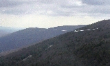
Bald Eagle Mountain
Encyclopedia
Bald Eagle Mountain, once known locally as Muncy Mountain, is a stratigraphic ridge
in central Pennsylvania
, United States
, running east of the Allegheny Front
and northwest of Mount Nittany
. It lies along the southeast side of Bald Eagle Creek
, and south of the West Branch Susquehanna River
, and is the westernmost ridge in its section of the Ridge-and-valley Appalachians
. The ridge line separates the West Branch Susquehanna Valley
from the Nippenose and White Deer Hole
Valleys, and Bald Eagle Valley
from Nittany Valley
.
Bald Eagle Mountain lies in the central portion of Centre County
, the southern portion of Clinton County
, the southern portion of Lycoming County
, and the ridge line forms part of the border between Blair County
and Huntingdon County
. It runs from the water gap
formed with Brush Mountain by the Little Juniata River
at Tyrone
, to the bend in the West Branch Susquehanna River just east of Williamsport
, a distance of approximately 60 miles (100 km).
The Julian
and Unionville
Pikes are paved roads that cross the ridge near State College
, along with and U.S. Route 322
and Interstate 99
which pass through the now enlarged wind gap known as "Skytop". Most other major road crossings are through gaps, including Interstate 80
which passes through the Curtin Gap east of Milesburg, Pennsylvania
. There are water gaps in the ridge formed by Spring Creek in Milesburg
and Fishing Creek
in Mill Hall (where U.S. Route 220
crosses). U.S. Route 15
crosses south of Williamsport
near Bald Eagle Mountain's eastern end.
Bald Eagle Ridge is popular with soaring birds and glider
pilots ridge soaring along its slopes. This ridge is part of a chain of ridges that stretch south to Tennessee
. The Ridge Soaring Gliderport
lies at the foot of this ridge between Julian and Unionville.
A mature oak and hickory forest covers the Bald Eagle Mountain.
It is one of the best sites in the eastern United States for viewing the migration of the golden eagle
.
. Brush Mountain, and neighboring Nittany Mountain
and Tussey Mountain
ridges, are part of the same Paleozoic
anticline
rock formation consisting of older Ordovicial
Bald Eagle Formation
Sandstone
and Juniata Formation
Shale
, and younger Silurian
Tuscarora Formation
Quartzite
.
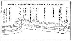 During the Appalachian orogeny, these layers folded
up with the underlying and overlying layers into the Nittany Arch. The arch was a Himalayan scale mountain that towered above what is now Nittany Valley
, where the oldest rock layers from deep within the eroded
mountain are now exposed. Younger rocks from the outer layers of the arch are exposed on the West side of the ridge in the Bald Eagle Valley
, with the youngest across the valley at the foot of the Allegheny Front
. These sedimentary rock
layers were tipped almost vertical on the side of the ancient mountain where Bald Eagle Mountain now lies.
The Tuscarora Quartzite is more resistant to erosion than Bald Eagle Sandstone, and both are more durable than the Juniata Shale sandwiched in-between. Softer rock layers on either side of these eroded, leaving the double crested Bald Eagle Mountain ridge, with a depression between the higher western and slightly lower eastern ridge lines. On the neighboring ridges that formed the opposite slope of the ancient mountain, the same three rock layers are exposed in reverse order, with the oldest rocks near the hinge of the fold. Since the rock layers on these ridges are not vertical, the Tuscarora Formation underlies a much higher crest, and the Bald Eagle Formation creates a series of lower "terraces" broken by small ravines.
The southeast slope of the ridge is underlaid by Juniata Formation
sandstone. The northwest slope of the ridge, where the rock layers are near vertical, exposes a series of rock layers, from summit to foot, or older to younger: Clinton Group
sandstone and shale, Mifflintown Formation shale and limestone, Bloomsburg Formation
shale, siltstone, sandstone, and mudstone, Wills Creek Formation
shale, siltstone, limestone, and dolomite, Tonoloway Formation
limestone, Keyser Formation
limestone, Old Port Formation
Shriver chert, Mandata shale, Corriganville chert, New Creek limestone and Ridgeley Member sandstone
, and Onondaga Formation calcareous shale.
The Bald Eagle Sandstone is also laced with pyrite
veins, and when exposed to air and water, these minerals produce sulfuric acid
, contaminating both surface runoff
and groundwater
. Construction of Interstate 99
where it crosses Bald Eagle Mountain has been delayed since 2004 by complaints from the Pennsylvania Department of Environmental Protection
about acidic runoff from pyritic rock
excavated from this formation. The planned I-99/I-80 interchange further north in the Nittany Valley at the foot of the ridge was redesigned to avoid excavating contaminated rock from the same formation.
Ridge
A ridge is a geological feature consisting of a chain of mountains or hills that form a continuous elevated crest for some distance. Ridges are usually termed hills or mountains as well, depending on size. There are several main types of ridges:...
in central Pennsylvania
Pennsylvania
The Commonwealth of Pennsylvania is a U.S. state that is located in the Northeastern and Mid-Atlantic regions of the United States. The state borders Delaware and Maryland to the south, West Virginia to the southwest, Ohio to the west, New York and Ontario, Canada, to the north, and New Jersey to...
, United States
United States
The United States of America is a federal constitutional republic comprising fifty states and a federal district...
, running east of the Allegheny Front
Allegheny Front
The Allegheny Front is the major southeast- or east-facing escarpment in the Allegheny Mountains in southern Pennsylvania, western Maryland, and eastern West Virginia, USA. The Allegheny Front delineates the Ridge-and-Valley Appalachians to its east from the Appalachian Plateau to its west...
and northwest of Mount Nittany
Mount Nittany
Mount Nittany is the common name for Nittany Mountain, a prominent geographic feature in Centre County, Pennsylvania. The mountain is actually part of a complex of ridges that separates Nittany Valley from Penns Valley, with the enclosed Sugar Valley between them...
. It lies along the southeast side of Bald Eagle Creek
Bald Eagle Creek (West Branch Susquehanna River)
Bald Eagle Creek is a tributary of the West Branch Susquehanna River mostly in Centre County, Pennsylvania, in the United States. It runs through the Bald Eagle Valley at the foot of the Bald Eagle Mountain ridge to Lock Haven....
, and south of the West Branch Susquehanna River
West Branch Susquehanna River
The West Branch Susquehanna River is one of the two principal branches, along with the North Branch, of the Susquehanna River in the northeastern United States. The North Branch, which rises in upstate New York, is generally regarded as the extension of the main branch, with the shorter West Branch...
, and is the westernmost ridge in its section of the Ridge-and-valley Appalachians
Ridge-and-valley Appalachians
The Ridge-and-Valley Appalachians, also called the Ridge and Valley Province or the Valley and Ridge Appalachians, are a physiographic province of the larger Appalachian division and are also a belt within the Appalachian Mountains extending from southeastern New York through northwestern New...
. The ridge line separates the West Branch Susquehanna Valley
West Branch Susquehanna Valley
The West Branch Susquehanna Valley of central Pennsylvania, United States, in the Ridge-and-valley Appalachians, is the low lying area draining into the West Branch Susquehanna River southeast of the Allegheny Front, northeast of the Bald Eagle Valley, southwest of the Wyoming Valley and nort of...
from the Nippenose and White Deer Hole
White Deer Hole Creek
White Deer Hole Creek is a tributary of the West Branch Susquehanna River in Clinton, Lycoming and Union counties in the U.S. state of Pennsylvania. A part of the Chesapeake Bay drainage basin, the White Deer Hole Creek watershed drains parts of ten townships...
Valleys, and Bald Eagle Valley
Bald Eagle Valley
The Bald Eagle Valley of central Pennsylvania, United States is the low lying area draining into the Bald Eagle Creek between the Allegheny Front and the Bald Eagle Mountain ridge, south of the West Branch Susquehanna River, in the Ridge-and-valley Appalachians...
from Nittany Valley
Nittany Valley
The Nittany Valley is an eroded anticlinal valley in the central portion of Centre County, Pennsylvania in the United States. It is separated from the Bald Eagle Valley by Bald Eagle Mountain and from Penns Valley by Mount Nittany. The valley is closed to the north by a high plateau that joins...
.
Bald Eagle Mountain lies in the central portion of Centre County
Centre County, Pennsylvania
Centre County is a county located in the U.S. state of Pennsylvania. It is part of the State College, Pennsylvania Metropolitan Statistical Area. As of 2010, the population was 153,990....
, the southern portion of Clinton County
Clinton County, Pennsylvania
As of the census of 2000, there were 37,914 people, 14,773 households, and 9,927 families residing in the county. The population density was 43 people per square mile . There were 18,166 housing units at an average density of 20 per square mile...
, the southern portion of Lycoming County
Lycoming County, Pennsylvania
-Appalachian Mountains and Allegheny Plateau:Lycoming County is divided between the Appalachian Mountains in the south, the dissected Allegheny Plateau in the north and east, and the valley of the West Branch Susquehanna River between these.-West Branch Susquehanna River:The West Branch of the...
, and the ridge line forms part of the border between Blair County
Blair County, Pennsylvania
-Significant Topographic Features:*Brush Mountain*Logan Valley*Morrison Cove*Tussey Mountain-Demographics:As of the census of 2000, there were 129,144 people, 51,518 households, and 34,877 families residing in the county. The population density was 246 people per square mile . There were 55,061...
and Huntingdon County
Huntingdon County, Pennsylvania
Huntingdon County is a county located in the U.S. state of Pennsylvania. In 2010, its population was 45,913.Huntingdon County was created on September 20, 1787, from part of Bedford County. Its county seat is Huntingdon.-Geography:According to the U.S...
. It runs from the water gap
Water gap
A water gap is an opening or notch which flowing water has carved through a mountain range. Water gaps often offer a practical route for road and rail transport to cross mountain ridges.- Geology :...
formed with Brush Mountain by the Little Juniata River
Little Juniata River
]The Little Juniata River, sometimes called the "Little J," is a river in central Pennsylvania. It is a tributary of the Juniata River in the Susquehanna River watershed. It is formed at Altoona by the confluence of several short streams...
at Tyrone
Tyrone, Pennsylvania
Tyrone is a borough in Blair County, Pennsylvania, northeast of Altoona, on the Little Juniata River. Tyrone was of considerable commercial importance in the twentieth century. It was an outlet for the Clearfield coal fields, and it was noted for the manufacture of paper products. There were...
, to the bend in the West Branch Susquehanna River just east of Williamsport
Williamsport, Pennsylvania
Williamsport is a city in and the county seat of Lycoming County, Pennsylvania in the United States. In 2009, the population was estimated at 29,304...
, a distance of approximately 60 miles (100 km).
The Julian
Julian, Pennsylvania
Julian, is a census-designated place in Centre County, Pennsylvania, United States. It is part of the State College, Pennsylvania Metropolitan Statistical Area. The population was 152 at the 2000 census...
and Unionville
Unionville, Centre County, Pennsylvania
Unionville is a borough in Centre County, Pennsylvania, United States. It is part of the State College, Pennsylvania Metropolitan Statistical Area...
Pikes are paved roads that cross the ridge near State College
State College, Pennsylvania
State College is the largest borough in Centre County in the U.S. state of Pennsylvania. It is the principal city of the State College, Pennsylvania Metropolitan Statistical Area which encompasses all of Centre County. As of the 2010 census, the borough population was 42,034, and roughly double...
, along with and U.S. Route 322
U.S. Route 322
U.S. Route 322 is a long, east–west United States Highway, traversing Ohio, Pennsylvania, and New Jersey. The road is a spur of U.S. Route 22 and one of the original highways from 1926...
and Interstate 99
Interstate 99
Interstate 99 is an intrastate Interstate Highway located in central Pennsylvania in the United States. The southern terminus of the route is at exit 146 of the Pennsylvania Turnpike north of Bedford, where the road continues south as U.S. Route 220 . The northern terminus is at...
which pass through the now enlarged wind gap known as "Skytop". Most other major road crossings are through gaps, including Interstate 80
Interstate 80 in Pennsylvania
The transcontinental Interstate 80 is designated across northern Pennsylvania as the Keystone Shortway, officially the Z.H. Confair Memorial Highway. This route was built mainly along a completely new alignment, not paralleling any earlier U.S. Routes, as a shortcut to the tolled Pennsylvania...
which passes through the Curtin Gap east of Milesburg, Pennsylvania
Milesburg, Pennsylvania
Milesburg is a borough in Centre County, Pennsylvania, United States. It is part of the State College, Pennsylvania Metropolitan Statistical Area. The population was 1,187 at the 2000 census...
. There are water gaps in the ridge formed by Spring Creek in Milesburg
Milesburg, Pennsylvania
Milesburg is a borough in Centre County, Pennsylvania, United States. It is part of the State College, Pennsylvania Metropolitan Statistical Area. The population was 1,187 at the 2000 census...
and Fishing Creek
Fishing Creek (Bald Eagle Creek)
Fishing Creek is a tributary of Bald Eagle Creek in Clinton County, Pennsylvania, in the United States.Fishing Creek passes through a water gap in Bald Eagle Mountain at Mill Hall, and joins Bald Eagle Creek near the borough of Flemington.-References:...
in Mill Hall (where U.S. Route 220
U.S. Route 220
U.S. Route 220 is a long U.S. Route in the eastern United States.US 220 is a spur route of U.S. Route 20 but at present, the two routes do not intersect nor do they connect via other spurs of US 20. The former U. S. Route 120, which was signed in Pennsylvania between 1926 and 1967, intersected...
crosses). U.S. Route 15
U.S. Route 15
U.S. Route 15 is a -long United States highway, designated along South Carolina, North Carolina, Virginia, Maryland, Pennsylvania, and New York. The route is signed north–south, from U.S. Route 17 Alternate in Walterboro, South Carolina to Interstate 86 and NY 17 in Painted Post, New York.US...
crosses south of Williamsport
Williamsport, Pennsylvania
Williamsport is a city in and the county seat of Lycoming County, Pennsylvania in the United States. In 2009, the population was estimated at 29,304...
near Bald Eagle Mountain's eastern end.
Bald Eagle Ridge is popular with soaring birds and glider
Glider (sailplane)
A glider or sailplane is a type of glider aircraft used in the sport of gliding. Some gliders, known as motor gliders are used for gliding and soaring as well, but have engines which can, in some cases, be used for take-off or for extending a flight...
pilots ridge soaring along its slopes. This ridge is part of a chain of ridges that stretch south to Tennessee
Tennessee
Tennessee is a U.S. state located in the Southeastern United States. It has a population of 6,346,105, making it the nation's 17th-largest state by population, and covers , making it the 36th-largest by total land area...
. The Ridge Soaring Gliderport
Ridge Soaring Gliderport
Ridge Soaring Gliderport is a public-use glider airport located two nautical miles southwest of the central business district of Unionville, in Centre County, Pennsylvania, United States. It is privately owned by Knauff & Grove, Inc....
lies at the foot of this ridge between Julian and Unionville.
A mature oak and hickory forest covers the Bald Eagle Mountain.
It is one of the best sites in the eastern United States for viewing the migration of the golden eagle
Golden Eagle
The Golden Eagle is one of the best known birds of prey in the Northern Hemisphere. Like all eagles, it belongs to the family Accipitridae. Once widespread across the Holarctic, it has disappeared from many of the more heavily populated areas...
.
Geology of Bald Eagle Mountain
Bald Eagle Mountain is in the western part of the Ridge and Valley province of the Appalachian MountainsAppalachian Mountains
The Appalachian Mountains #Whether the stressed vowel is or ,#Whether the "ch" is pronounced as a fricative or an affricate , and#Whether the final vowel is the monophthong or the diphthong .), often called the Appalachians, are a system of mountains in eastern North America. The Appalachians...
. Brush Mountain, and neighboring Nittany Mountain
Mount Nittany
Mount Nittany is the common name for Nittany Mountain, a prominent geographic feature in Centre County, Pennsylvania. The mountain is actually part of a complex of ridges that separates Nittany Valley from Penns Valley, with the enclosed Sugar Valley between them...
and Tussey Mountain
Tussey Mountain
]Tussey Mountain is a stratigraphic ridge in central Pennsylvania, United States, trending east of the Bald Eagle, Brush, Dunning and Evitts Mountain ridges...
ridges, are part of the same Paleozoic
Paleozoic
The Paleozoic era is the earliest of three geologic eras of the Phanerozoic eon, spanning from roughly...
anticline
Anticline
In structural geology, an anticline is a fold that is convex up and has its oldest beds at its core. The term is not to be confused with antiform, which is a purely descriptive term for any fold that is convex up. Therefore if age relationships In structural geology, an anticline is a fold that is...
rock formation consisting of older Ordovicial
Ordovician
The Ordovician is a geologic period and system, the second of six of the Paleozoic Era, and covers the time between 488.3±1.7 to 443.7±1.5 million years ago . It follows the Cambrian Period and is followed by the Silurian Period...
Bald Eagle Formation
Bald Eagle Formation
The Ordovician Bald Eagle Formation is a mapped bedrock unit in central Pennsylvania, USA. It is a ridge-forming unit in the Appalachian Mountains.-Description:...
Sandstone
Sandstone
Sandstone is a sedimentary rock composed mainly of sand-sized minerals or rock grains.Most sandstone is composed of quartz and/or feldspar because these are the most common minerals in the Earth's crust. Like sand, sandstone may be any colour, but the most common colours are tan, brown, yellow,...
and Juniata Formation
Juniata Formation
The Ordovician Juniata Formation is a mapped bedrock unit in Pennsylvania and Maryland. It is a relative slope-former occurring between the two prominent ridge-forming sandstone units: the Tuscarora Formation and the Bald Eagle Formation in the Appalachian Mountains.-Description:The Juniata is...
Shale
Shale
Shale is a fine-grained, clastic sedimentary rock composed of mud that is a mix of flakes of clay minerals and tiny fragments of other minerals, especially quartz and calcite. The ratio of clay to other minerals is variable. Shale is characterized by breaks along thin laminae or parallel layering...
, and younger Silurian
Silurian
The Silurian is a geologic period and system that extends from the end of the Ordovician Period, about 443.7 ± 1.5 Mya , to the beginning of the Devonian Period, about 416.0 ± 2.8 Mya . As with other geologic periods, the rock beds that define the period's start and end are well identified, but the...
Tuscarora Formation
Tuscarora Formation
The Silurian Tuscarora Formation — also known as Tuscarora Sandstone or Tuscarora Quartzite — is a mapped bedrock unit in Pennsylvania, Maryland, West Virginia, and Virginia.-Description:...
Quartzite
Quartzite
Quartzite is a hard metamorphic rock which was originally sandstone. Sandstone is converted into quartzite through heating and pressure usually related to tectonic compression within orogenic belts. Pure quartzite is usually white to gray, though quartzites often occur in various shades of pink...
.
Fold (geology)
The term fold is used in geology when one or a stack of originally flat and planar surfaces, such as sedimentary strata, are bent or curved as a result of permanent deformation. Synsedimentary folds are those due to slumping of sedimentary material before it is lithified. Folds in rocks vary in...
up with the underlying and overlying layers into the Nittany Arch. The arch was a Himalayan scale mountain that towered above what is now Nittany Valley
Nittany Valley
The Nittany Valley is an eroded anticlinal valley in the central portion of Centre County, Pennsylvania in the United States. It is separated from the Bald Eagle Valley by Bald Eagle Mountain and from Penns Valley by Mount Nittany. The valley is closed to the north by a high plateau that joins...
, where the oldest rock layers from deep within the eroded
Erosion
Erosion is when materials are removed from the surface and changed into something else. It only works by hydraulic actions and transport of solids in the natural environment, and leads to the deposition of these materials elsewhere...
mountain are now exposed. Younger rocks from the outer layers of the arch are exposed on the West side of the ridge in the Bald Eagle Valley
Bald Eagle Valley
The Bald Eagle Valley of central Pennsylvania, United States is the low lying area draining into the Bald Eagle Creek between the Allegheny Front and the Bald Eagle Mountain ridge, south of the West Branch Susquehanna River, in the Ridge-and-valley Appalachians...
, with the youngest across the valley at the foot of the Allegheny Front
Allegheny Front
The Allegheny Front is the major southeast- or east-facing escarpment in the Allegheny Mountains in southern Pennsylvania, western Maryland, and eastern West Virginia, USA. The Allegheny Front delineates the Ridge-and-Valley Appalachians to its east from the Appalachian Plateau to its west...
. These sedimentary rock
Sedimentary rock
Sedimentary rock are types of rock that are formed by the deposition of material at the Earth's surface and within bodies of water. Sedimentation is the collective name for processes that cause mineral and/or organic particles to settle and accumulate or minerals to precipitate from a solution....
layers were tipped almost vertical on the side of the ancient mountain where Bald Eagle Mountain now lies.
The Tuscarora Quartzite is more resistant to erosion than Bald Eagle Sandstone, and both are more durable than the Juniata Shale sandwiched in-between. Softer rock layers on either side of these eroded, leaving the double crested Bald Eagle Mountain ridge, with a depression between the higher western and slightly lower eastern ridge lines. On the neighboring ridges that formed the opposite slope of the ancient mountain, the same three rock layers are exposed in reverse order, with the oldest rocks near the hinge of the fold. Since the rock layers on these ridges are not vertical, the Tuscarora Formation underlies a much higher crest, and the Bald Eagle Formation creates a series of lower "terraces" broken by small ravines.
The southeast slope of the ridge is underlaid by Juniata Formation
Juniata Formation
The Ordovician Juniata Formation is a mapped bedrock unit in Pennsylvania and Maryland. It is a relative slope-former occurring between the two prominent ridge-forming sandstone units: the Tuscarora Formation and the Bald Eagle Formation in the Appalachian Mountains.-Description:The Juniata is...
sandstone. The northwest slope of the ridge, where the rock layers are near vertical, exposes a series of rock layers, from summit to foot, or older to younger: Clinton Group
Clinton Group
The Silurian Clinton Group is a mapped bedrock unit in New York, Pennsylvania, Maryland, and West Virginia. It contains the Rochester Shale, Rose Hill Formation and the ridge-forming Keefer Formation...
sandstone and shale, Mifflintown Formation shale and limestone, Bloomsburg Formation
Bloomsburg Formation
The Silurian Bloomsburg Formation is a mapped bedrock unit in Pennsylvania, New Jersey, New York and Maryland. It is named for the Town of Bloomsburg, Pennsylvania for which it was first described. The Bloomsburg marked the first occurrence of red sedimentary rocks in the Appalachian Basin...
shale, siltstone, sandstone, and mudstone, Wills Creek Formation
Wills Creek Formation
The Silurian Wills Creek Formation is a mapped bedrock unit in Pennsylvania, Maryland, Virginia, and West Virginia.-Description:The Wills Creek is defined as a moderately well bedded greenish-gray shale containing local limestone and sandstone zones, or more specifically as an olive to...
shale, siltstone, limestone, and dolomite, Tonoloway Formation
Tonoloway Formation
The Late Silurian Tonoloway Formation is a mapped limestone bedrock unit in Pennsylvania, Maryland, Virginia and West Virginia.-Description:The basal 50 m consists of medium-dark-gray laminated to thin-bedded calcisiltite with shale partings and interbeds. Overlying 5 m are light-yellowish-gray to...
limestone, Keyser Formation
Keyser Formation
The Late Silurian to Early Devonian Keyser Formation is a mapped limestone bedrock unit in Pennsylvania, Maryland, Virginia, and West Virginia.-Description:...
limestone, Old Port Formation
Old Port Formation
The Devonian Old Port Formation is a mapped bedrock unit in Pennsylvania, Maryland, and West Virginia. Members of the unit are also mapped in New Jersey and Virginia as parts of other formations or groups.-Description:...
Shriver chert, Mandata shale, Corriganville chert, New Creek limestone and Ridgeley Member sandstone
Ridgeley sandstone
The Ridgeley sandstone is a sandstone or quartzite of Devonian age found in the Appalachian Mountains of Pennsylvania, Maryland, West Virginia, and Virginia, USA. The Ridgeley is fine-grained, siliceous, calcareous in its lower strata, sometimes fossiliferous, and sometimes locally pebbly or...
, and Onondaga Formation calcareous shale.
The Bald Eagle Sandstone is also laced with pyrite
Pyrite
The mineral pyrite, or iron pyrite, is an iron sulfide with the formula FeS2. This mineral's metallic luster and pale-to-normal, brass-yellow hue have earned it the nickname fool's gold because of its resemblance to gold...
veins, and when exposed to air and water, these minerals produce sulfuric acid
Sulfuric acid
Sulfuric acid is a strong mineral acid with the molecular formula . Its historical name is oil of vitriol. Pure sulfuric acid is a highly corrosive, colorless, viscous liquid. The salts of sulfuric acid are called sulfates...
, contaminating both surface runoff
Surface runoff
Surface runoff is the water flow that occurs when soil is infiltrated to full capacity and excess water from rain, meltwater, or other sources flows over the land. This is a major component of the water cycle. Runoff that occurs on surfaces before reaching a channel is also called a nonpoint source...
and groundwater
Groundwater
Groundwater is water located beneath the ground surface in soil pore spaces and in the fractures of rock formations. A unit of rock or an unconsolidated deposit is called an aquifer when it can yield a usable quantity of water. The depth at which soil pore spaces or fractures and voids in rock...
. Construction of Interstate 99
Interstate 99
Interstate 99 is an intrastate Interstate Highway located in central Pennsylvania in the United States. The southern terminus of the route is at exit 146 of the Pennsylvania Turnpike north of Bedford, where the road continues south as U.S. Route 220 . The northern terminus is at...
where it crosses Bald Eagle Mountain has been delayed since 2004 by complaints from the Pennsylvania Department of Environmental Protection
Pennsylvania Department of Environmental Protection
The Pennsylvania Department of Environmental Protection was established on July 1, 1995, is the agency in the U.S. State of Pennsylvania responsible for protecting and preserving the land, air, water, and energy resources through enforcement of the State's environmental laws...
about acidic runoff from pyritic rock
Pyrite
The mineral pyrite, or iron pyrite, is an iron sulfide with the formula FeS2. This mineral's metallic luster and pale-to-normal, brass-yellow hue have earned it the nickname fool's gold because of its resemblance to gold...
excavated from this formation. The planned I-99/I-80 interchange further north in the Nittany Valley at the foot of the ridge was redesigned to avoid excavating contaminated rock from the same formation.