

Keyser Formation
Encyclopedia
The Late Silurian
to Early Devonian
Keyser Formation is a mapped limestone
bedrock
unit in Pennsylvania
, Maryland
, Virginia
, and West Virginia
.
.
In central Pennsylvania, the basal "calico" limestone is a fossiliferous, medium-light- to medium-gray very thick bedded calcilutite containing numerous small irregular patches of clear calcite. The abundantly fossiliferous, nodular limestone at the base overlies the "calico". Overlying this is 5 to 6 m of fragmental calcarenite containing abundant crinoid
columnals. Above the calcarenite is 6 m of fossiliferous, banded calcisiltite
. The uppermost 15 m is a sequence alternating between laminated, stromatolitic
calcisiltite, and calcilutite
and calcisiltite that are argillaceous and fossiliferous.
. Upper contact with the Old Port Formation
is conformable.
The Keyser was divided into three members by J. W. Head in 1972. These are, from lowest to highest, the Byers Island Member, Jersey Shore Member, and La Vale Member. The type locality of the Byers Island Member is at Selinsgrove
, Pennsylvania, where it is 93 feet thick. The type locality of the Jersey Shore Member is at Jersey Shore
, Lycoming County
, Pennsylvania. The type locality of the La Vale Member is at the Corriganville
quarry, Allegany County
, Maryland, and is named from nearby town of La Vale
. This nomenclature is accepted by the USGS
.
In Virginia and West Virginia the Keyser is divided into Upper and Lower Members by the Big Mountain Shale Member.
to early Devonian
, with the transition occurring near the top of the formation. Denkler and Harris used conodont
biostratigraphy
to confirm this.
Silurian
The Silurian is a geologic period and system that extends from the end of the Ordovician Period, about 443.7 ± 1.5 Mya , to the beginning of the Devonian Period, about 416.0 ± 2.8 Mya . As with other geologic periods, the rock beds that define the period's start and end are well identified, but the...
to Early Devonian
Devonian
The Devonian is a geologic period and system of the Paleozoic Era spanning from the end of the Silurian Period, about 416.0 ± 2.8 Mya , to the beginning of the Carboniferous Period, about 359.2 ± 2.5 Mya...
Keyser Formation is a mapped limestone
Limestone
Limestone is a sedimentary rock composed largely of the minerals calcite and aragonite, which are different crystal forms of calcium carbonate . Many limestones are composed from skeletal fragments of marine organisms such as coral or foraminifera....
bedrock
Bedrock
In stratigraphy, bedrock is the native consolidated rock underlying the surface of a terrestrial planet, usually the Earth. Above the bedrock is usually an area of broken and weathered unconsolidated rock in the basal subsoil...
unit in Pennsylvania
Pennsylvania
The Commonwealth of Pennsylvania is a U.S. state that is located in the Northeastern and Mid-Atlantic regions of the United States. The state borders Delaware and Maryland to the south, West Virginia to the southwest, Ohio to the west, New York and Ontario, Canada, to the north, and New Jersey to...
, Maryland
Maryland
Maryland is a U.S. state located in the Mid Atlantic region of the United States, bordering Virginia, West Virginia, and the District of Columbia to its south and west; Pennsylvania to its north; and Delaware to its east...
, Virginia
Virginia
The Commonwealth of Virginia , is a U.S. state on the Atlantic Coast of the Southern United States. Virginia is nicknamed the "Old Dominion" and sometimes the "Mother of Presidents" after the eight U.S. presidents born there...
, and West Virginia
West Virginia
West Virginia is a state in the Appalachian and Southeastern regions of the United States, bordered by Virginia to the southeast, Kentucky to the southwest, Ohio to the northwest, Pennsylvania to the northeast and Maryland to the east...
.
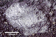
Description
The Keyser is a nodular limestone overlain by thick- and thin-bedded limestone and laminated limestone at its type locality in Keyser, West VirginiaKeyser, West Virginia
Keyser is a city in and the county seat of Mineral County, West Virginia, United States. It is part of the Cumberland, MD-WV Metropolitan Statistical Area. The population was 5,303 at the 2000 census.- History :...
.
In central Pennsylvania, the basal "calico" limestone is a fossiliferous, medium-light- to medium-gray very thick bedded calcilutite containing numerous small irregular patches of clear calcite. The abundantly fossiliferous, nodular limestone at the base overlies the "calico". Overlying this is 5 to 6 m of fragmental calcarenite containing abundant crinoid
Crinoid
Crinoids are marine animals that make up the class Crinoidea of the echinoderms . Crinoidea comes from the Greek word krinon, "a lily", and eidos, "form". They live both in shallow water and in depths as great as 6,000 meters. Sea lilies refer to the crinoids which, in their adult form, are...
columnals. Above the calcarenite is 6 m of fossiliferous, banded calcisiltite
Calcisiltite
Calcisiltite is a type of limestone that is composed predominately, more than 50 percent, of detrital silt-size carbonate grains. These grains consist either of the silt-size particles of ooids, fragments of fossil shells, fragments of older limestones and dolomites, intraclasts, pellets, other...
. The uppermost 15 m is a sequence alternating between laminated, stromatolitic
Stromatolite
Stromatolites or stromatoliths are layered accretionary structures formed in shallow water by the trapping, binding and cementation of sedimentary grains by biofilms of microorganisms, especially cyanobacteria ....
calcisiltite, and calcilutite
Calcilutite
Calcilutite is a type of limestone that is composed of predominately, more than 50 percent, of either clay-size or both silt-size and clay-size detrital carbonate grains. These grains consist either of fossil fragments, ooids, intraclasts, pellets, other grains, or some combination of them...
and calcisiltite that are argillaceous and fossiliferous.
Depositional Environment
The depostional environment of the Keyser is interpreted as shallow marine and tidal flats, occurring in cycles.Stratigraphy
Contact with Tonoloway Formation is probably conformable, but sharp enough to suggest an unconformityUnconformity
An unconformity is a buried erosion surface separating two rock masses or strata of different ages, indicating that sediment deposition was not continuous. In general, the older layer was exposed to erosion for an interval of time before deposition of the younger, but the term is used to describe...
. Upper contact with the Old Port Formation
Old Port Formation
The Devonian Old Port Formation is a mapped bedrock unit in Pennsylvania, Maryland, and West Virginia. Members of the unit are also mapped in New Jersey and Virginia as parts of other formations or groups.-Description:...
is conformable.
The Keyser was divided into three members by J. W. Head in 1972. These are, from lowest to highest, the Byers Island Member, Jersey Shore Member, and La Vale Member. The type locality of the Byers Island Member is at Selinsgrove
Selinsgrove, Pennsylvania
Selinsgrove is a borough in Snyder County, Pennsylvania, United States. It was founded in 1787 by Captain Anthony Selin, who fought with Washington in the Revolutionary War....
, Pennsylvania, where it is 93 feet thick. The type locality of the Jersey Shore Member is at Jersey Shore
Jersey Shore, Pennsylvania
Jersey Shore is a borough in Lycoming County, Pennsylvania, United States. It is on the West Branch Susquehanna River, west by south of Williamsport. It is part of the Williamsport, Pennsylvania Metropolitan Statistical Area. In the past, Jersey Shore held farms, railroad shops, cigar factories, a...
, Lycoming County
Lycoming County, Pennsylvania
-Appalachian Mountains and Allegheny Plateau:Lycoming County is divided between the Appalachian Mountains in the south, the dissected Allegheny Plateau in the north and east, and the valley of the West Branch Susquehanna River between these.-West Branch Susquehanna River:The West Branch of the...
, Pennsylvania. The type locality of the La Vale Member is at the Corriganville
Corriganville, Maryland
Corriganville is an unincorporated town in Allegany County, Maryland, USA. The town lies north of Cumberland at the confluence of Wills Creek and Jennings Run...
quarry, Allegany County
Allegany County, Maryland
Allegany County is a county located in the northwestern part of the US state of Maryland. It is part of the Cumberland, MD-WV Metropolitan Statistical Area. As of 2010, the population was 75,087. Its county seat is Cumberland...
, Maryland, and is named from nearby town of La Vale
La Vale, Maryland
La Vale is a census-designated place in Allegany County, Maryland, United States. It is part of the 'Cumberland, MD-WV Metropolitan Statistical Area'...
. This nomenclature is accepted by the USGS
United States Geological Survey
The United States Geological Survey is a scientific agency of the United States government. The scientists of the USGS study the landscape of the United States, its natural resources, and the natural hazards that threaten it. The organization has four major science disciplines, concerning biology,...
.
In Virginia and West Virginia the Keyser is divided into Upper and Lower Members by the Big Mountain Shale Member.
Fossils
- crinoidCrinoidCrinoids are marine animals that make up the class Crinoidea of the echinoderms . Crinoidea comes from the Greek word krinon, "a lily", and eidos, "form". They live both in shallow water and in depths as great as 6,000 meters. Sea lilies refer to the crinoids which, in their adult form, are...
columnals - stromatoporoids
- BrachiopodBrachiopodBrachiopods are a phylum of marine animals that have hard "valves" on the upper and lower surfaces, unlike the left and right arrangement in bivalve molluscs. Brachiopod valves are hinged at the rear end, while the front can be opened for feeding or closed for protection...
s - Tabulate coralTabulate coralThe tabulate corals, forming the order Tabulata, are an extinct form of coral. They are almost always colonial, forming colonies of individual hexagonal cells known as corallites defined by a skeleton of calcite, similar in appearance to a honeycomb. Adjacent cells are joined by small pores...
s - Conodonts: Icriodus woschmidti, Oulodus elegans, O. cristagalli
Notable Exposures
- Keyser, West VirginiaKeyser, West VirginiaKeyser is a city in and the county seat of Mineral County, West Virginia, United States. It is part of the Cumberland, MD-WV Metropolitan Statistical Area. The population was 5,303 at the 2000 census.- History :...
(type section), quarry and roadcut east of the town, on West Virginia Secondary Road 8 - Old Eldorado Quarry, at Mile Marker 30 along I-99Interstate 99Interstate 99 is an intrastate Interstate Highway located in central Pennsylvania in the United States. The southern terminus of the route is at exit 146 of the Pennsylvania Turnpike north of Bedford, where the road continues south as U.S. Route 220 . The northern terminus is at...
/U.S. Route 220 in Blair County, PennsylvaniaBlair County, Pennsylvania-Significant Topographic Features:*Brush Mountain*Logan Valley*Morrison Cove*Tussey Mountain-Demographics:As of the census of 2000, there were 129,144 people, 51,518 households, and 34,877 families residing in the county. The population density was 246 people per square mile . There were 55,061... - Alleghany Furnace Quarry, AltoonaAltoona, Pennsylvania-History:A major railroad town, Altoona was founded by the Pennsylvania Railroad in 1849 as the site for a shop complex. Altoona was incorporated as a borough on February 6, 1854, and as a city under legislation approved on April 3, 1867, and February 8, 1868...
, Pennsylvania - St. Clairsville/Osterburg Exit of I-99Interstate 99Interstate 99 is an intrastate Interstate Highway located in central Pennsylvania in the United States. The southern terminus of the route is at exit 146 of the Pennsylvania Turnpike north of Bedford, where the road continues south as U.S. Route 220 . The northern terminus is at...
in Bedford CountyBedford County, PennsylvaniaBedford County is a county located in the U.S. state of Pennsylvania. As of the 2010 census, the population was 49,762. The county seat is Bedford. It is part of the Altoona, Pennsylvania, Metropolitan Statistical Area.- History :...
, Pennsylvania (nearly vertical orientation) - Abandoned quarry in TyroneTyrone, PennsylvaniaTyrone is a borough in Blair County, Pennsylvania, northeast of Altoona, on the Little Juniata River. Tyrone was of considerable commercial importance in the twentieth century. It was an outlet for the Clearfield coal fields, and it was noted for the manufacture of paper products. There were...
, Pennsylvania - Quarry at Canoe Creek, Pennsylvania
- New Enterprise New ParisNew Paris, PennsylvaniaNew Paris is a borough in Bedford County, Pennsylvania, United States. The population was 214 at the 2000 census. New Paris is located northwest of Bedford, north of Schellsburg and ENE of Somerset.-History:...
Quarry, Chestnut RidgeChestnut Ridge, Bedford CountyChestnut Ridge is an elongate hill trending northeast-southwest in west-central Bedford County, Pennsylvania. It is partially forested with rural homes, farms, and notably apple orchards. Four small towns surround it: Schellsburg, New Paris, Fishertown, and Pleasantville...
, Bedford CountyBedford County, PennsylvaniaBedford County is a county located in the U.S. state of Pennsylvania. As of the 2010 census, the population was 49,762. The county seat is Bedford. It is part of the Altoona, Pennsylvania, Metropolitan Statistical Area.- History :...
, Pennsylvania - Roadcut along U.S. Route 30U.S. Route 30U.S. Route 30 is an east–west main route of the system of United States Numbered Highways, with the highway traveling across the northern tier of the country. It is the third longest U.S. route, after U.S. Route 20 and U.S. Route 6. The western end of the highway is at Astoria, Oregon; the...
(Everett bypass) through Warrior RidgeWarrior MountainWarrior Mountain is a ridge located in Allegany County, Maryland. Warrior Mountain begins northwest of Oldtown, Maryland and runs northeasterly to the water gap formed by the Murley Branch of Town Creek, south of Flintstone, Maryland...
, Bedford CountyBedford County, PennsylvaniaBedford County is a county located in the U.S. state of Pennsylvania. As of the 2010 census, the population was 49,762. The county seat is Bedford. It is part of the Altoona, Pennsylvania, Metropolitan Statistical Area.- History :...
, Pennsylvania - Strait Creek section on County Road 629, 1.5 miles south of U.S. Route 220U.S. Route 220U.S. Route 220 is a long U.S. Route in the eastern United States.US 220 is a spur route of U.S. Route 20 but at present, the two routes do not intersect nor do they connect via other spurs of US 20. The former U. S. Route 120, which was signed in Pennsylvania between 1926 and 1967, intersected...
, Strait Creek, Highland CountyHighland County, VirginiaAs of the census of 2000, there were 2,536 people, 1,131 households, and 764 families residing in the county. The population density was 6 people per square mile . There were 1,822 housing units at an average density of 4 per square mile...
, Virginia - Smoke Hole section on West Virginia Route 2, 1.5 miles west of U.S. Route 220U.S. Route 220U.S. Route 220 is a long U.S. Route in the eastern United States.US 220 is a spur route of U.S. Route 20 but at present, the two routes do not intersect nor do they connect via other spurs of US 20. The former U. S. Route 120, which was signed in Pennsylvania between 1926 and 1967, intersected...
, Pendleton CountyPendleton County, West VirginiaAs of the census of 2000, there were 8,196 people, 3,350 households, and 2,355 families residing in the county. The population density was 12 people per square mile . There were 5,102 housing units at an average density of 7 per square mile...
, West Virginia
Age
Relative age dating places the Keyser in the late SilurianSilurian
The Silurian is a geologic period and system that extends from the end of the Ordovician Period, about 443.7 ± 1.5 Mya , to the beginning of the Devonian Period, about 416.0 ± 2.8 Mya . As with other geologic periods, the rock beds that define the period's start and end are well identified, but the...
to early Devonian
Devonian
The Devonian is a geologic period and system of the Paleozoic Era spanning from the end of the Silurian Period, about 416.0 ± 2.8 Mya , to the beginning of the Carboniferous Period, about 359.2 ± 2.5 Mya...
, with the transition occurring near the top of the formation. Denkler and Harris used conodont
Conodont
Conodonts are extinct chordates resembling eels, classified in the class Conodonta. For many years, they were known only from tooth-like microfossils now called conodont elements, found in isolation. Knowledge about soft tissues remains relatively sparse to this day...
biostratigraphy
Biostratigraphy
Biostratigraphy is the branch of stratigraphy which focuses on correlating and assigning relative ages of rock strata by using the fossil assemblages contained within them. Usually the aim is correlation, demonstrating that a particular horizon in one geological section represents the same period...
to confirm this.