Clinton County, Pennsylvania
Encyclopedia
As of the census
of 2000, there were 37,914 people, 14,773 households, and 9,927 families residing in the county. The population density
was 43 people per square mile (16/km²). There were 18,166 housing units at an average density of 20 per square mile (8/km²). The racial makeup of the county was 98.29% White
, 0.52% Black
or African American
, 0.11% Native American
, 0.40% Asian
, 0.02% Pacific Islander
, 0.15% from other races
, and 0.52% from two or more races. 0.54% of the population were Hispanic
or Latino
of any race. 36.0% were of German, 15.6% American
, 9.6% Irish
, 8.6% Italian
and 7.4% English
ancestry according to Census 2000.
There were 14,773 households out of which 27.70% had children under the age of 18 living with them, 54.00% were married couples
living together, 9.40% had a female householder with no husband present, and 32.80% were non-families. 26.60% of all households were made up of individuals and 13.60% had someone living alone who was 65 years of age or older. The average household size was 2.42 and the average family size was 2.90.
In the county, the population was spread out with 21.50% under the age of 18, 13.60% from 18 to 24, 25.50% from 25 to 44, 22.70% from 45 to 64, and 16.80% who were 65 years of age or older. The median age was 38 years. For every 100 females there were 94.20 males. For every 100 females age 18 and over, there were 91.20 males.
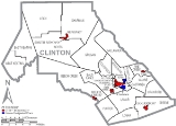
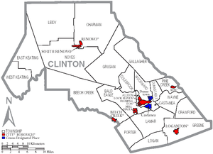
 Under Pennsylvania law, there are four types of incorporated municipalities: cities, boroughs, townships, and, in at most two cases, towns. The following cities, boroughs and townships are located in Clinton County:
s are geographical areas designated by the U.S. Census Bureau
for the purposes of compiling demographic data. They are not actual jurisdictions under Pennsylvania law. Other unincorporated communities, such as villages, may be listed here as well.

Census
A census is the procedure of systematically acquiring and recording information about the members of a given population. It is a regularly occurring and official count of a particular population. The term is used mostly in connection with national population and housing censuses; other common...
of 2000, there were 37,914 people, 14,773 households, and 9,927 families residing in the county. The population density
Population density
Population density is a measurement of population per unit area or unit volume. It is frequently applied to living organisms, and particularly to humans...
was 43 people per square mile (16/km²). There were 18,166 housing units at an average density of 20 per square mile (8/km²). The racial makeup of the county was 98.29% White
Race (United States Census)
Race and ethnicity in the United States Census, as defined by the Federal Office of Management and Budget and the United States Census Bureau, are self-identification data items in which residents choose the race or races with which they most closely identify, and indicate whether or not they are...
, 0.52% Black
Race (United States Census)
Race and ethnicity in the United States Census, as defined by the Federal Office of Management and Budget and the United States Census Bureau, are self-identification data items in which residents choose the race or races with which they most closely identify, and indicate whether or not they are...
or African American
Race (United States Census)
Race and ethnicity in the United States Census, as defined by the Federal Office of Management and Budget and the United States Census Bureau, are self-identification data items in which residents choose the race or races with which they most closely identify, and indicate whether or not they are...
, 0.11% Native American
Race (United States Census)
Race and ethnicity in the United States Census, as defined by the Federal Office of Management and Budget and the United States Census Bureau, are self-identification data items in which residents choose the race or races with which they most closely identify, and indicate whether or not they are...
, 0.40% Asian
Race (United States Census)
Race and ethnicity in the United States Census, as defined by the Federal Office of Management and Budget and the United States Census Bureau, are self-identification data items in which residents choose the race or races with which they most closely identify, and indicate whether or not they are...
, 0.02% Pacific Islander
Race (United States Census)
Race and ethnicity in the United States Census, as defined by the Federal Office of Management and Budget and the United States Census Bureau, are self-identification data items in which residents choose the race or races with which they most closely identify, and indicate whether or not they are...
, 0.15% from other races
Race (United States Census)
Race and ethnicity in the United States Census, as defined by the Federal Office of Management and Budget and the United States Census Bureau, are self-identification data items in which residents choose the race or races with which they most closely identify, and indicate whether or not they are...
, and 0.52% from two or more races. 0.54% of the population were Hispanic
Race (United States Census)
Race and ethnicity in the United States Census, as defined by the Federal Office of Management and Budget and the United States Census Bureau, are self-identification data items in which residents choose the race or races with which they most closely identify, and indicate whether or not they are...
or Latino
Race (United States Census)
Race and ethnicity in the United States Census, as defined by the Federal Office of Management and Budget and the United States Census Bureau, are self-identification data items in which residents choose the race or races with which they most closely identify, and indicate whether or not they are...
of any race. 36.0% were of German, 15.6% American
United States
The United States of America is a federal constitutional republic comprising fifty states and a federal district...
, 9.6% Irish
Irish people
The Irish people are an ethnic group who originate in Ireland, an island in northwestern Europe. Ireland has been populated for around 9,000 years , with the Irish people's earliest ancestors recorded having legends of being descended from groups such as the Nemedians, Fomorians, Fir Bolg, Tuatha...
, 8.6% Italian
Italian people
The Italian people are an ethnic group that share a common Italian culture, ancestry and speak the Italian language as a mother tongue. Within Italy, Italians are defined by citizenship, regardless of ancestry or country of residence , and are distinguished from people...
and 7.4% English
English people
The English are a nation and ethnic group native to England, who speak English. The English identity is of early mediaeval origin, when they were known in Old English as the Anglecynn. England is now a country of the United Kingdom, and the majority of English people in England are British Citizens...
ancestry according to Census 2000.
There were 14,773 households out of which 27.70% had children under the age of 18 living with them, 54.00% were married couples
Marriage
Marriage is a social union or legal contract between people that creates kinship. It is an institution in which interpersonal relationships, usually intimate and sexual, are acknowledged in a variety of ways, depending on the culture or subculture in which it is found...
living together, 9.40% had a female householder with no husband present, and 32.80% were non-families. 26.60% of all households were made up of individuals and 13.60% had someone living alone who was 65 years of age or older. The average household size was 2.42 and the average family size was 2.90.
In the county, the population was spread out with 21.50% under the age of 18, 13.60% from 18 to 24, 25.50% from 25 to 44, 22.70% from 45 to 64, and 16.80% who were 65 years of age or older. The median age was 38 years. For every 100 females there were 94.20 males. For every 100 females age 18 and over, there were 91.20 males.
Municipalities

Boroughs
|
Renovo, Pennsylvania Renovo is a borough in Clinton County, Pennsylvania, northwest of Lock Haven. Deposits of bituminous coal and fire clay are in the region. In 1900, 4,082 people lived there, and in 1910, 4,621 lived there... South Renovo, Pennsylvania South Renovo is a borough in Clinton County, Pennsylvania, United States. The population was 557 at the 2000 census.-Geography:South Renovo is located at .... |
Townships
|
Greene Township, Clinton County, Pennsylvania Greene Township is a township in Clinton County, Pennsylvania, United States. The population was 1,464 at the 2000 census.-Geography:According to the United States Census Bureau, the township has a total area of , of which, of it is land and of it is water.-Demographics:As of the census of 2000,... |
Logan Township, Clinton County, Pennsylvania Logan Township is a township in Clinton County, Pennsylvania, United States. The population was 773 at the 2000 census.-Geography:According to the United States Census Bureau, the township has a total area of 24.0 square miles , all of it land.-Demographics:As of the census of 2000, there were... Pine Creek Township, Clinton County, Pennsylvania Pine Creek Township is a township in Clinton County, Pennsylvania, United States. The population was 3,184 at the 2000 census. Pine Creek Township is named for Pine Creek which flows into the West Branch Susquehanna River at the border of the township is Lycoming County between the boroughs of Avis... Porter Township, Clinton County, Pennsylvania Porter Township is a township in Clinton County, Pennsylvania, United States. The population was 1,419 at the 2000 census.-Geography:According to the United States Census Bureau, the township has a total area of 25.7 square miles , of which, 25.7 square miles of it is land and... Wayne Township, Clinton County, Pennsylvania Wayne Township is a township located in Clinton County, Pennsylvania. As of the 2000 census, the township had a total population of 1,363.- Geography :... Woodward Township, Clinton County, Pennsylvania Woodward Township is a township in Clinton County, Pennsylvania, United States. The population was 2,296 at the 2000 census.-Geography:According to the United States Census Bureau, the township has a total area of 18.3 square miles , of which, 17.9 square miles of it is land and... |
Census-designated places
Census-designated placeCensus-designated place
A census-designated place is a concentration of population identified by the United States Census Bureau for statistical purposes. CDPs are delineated for each decennial census as the statistical counterparts of incorporated places such as cities, towns and villages...
s are geographical areas designated by the U.S. Census Bureau
United States Census Bureau
The United States Census Bureau is the government agency that is responsible for the United States Census. It also gathers other national demographic and economic data...
for the purposes of compiling demographic data. They are not actual jurisdictions under Pennsylvania law. Other unincorporated communities, such as villages, may be listed here as well.
- CastaneaCastanea, PennsylvaniaCastanea is a census-designated place in Castanea Township, Clinton County, Pennsylvania, United States. The population was 1,189 at the 2000 census.-Geography:Castanea is located at ....
- DunnstownDunnstown, PennsylvaniaDunnstown is a census-designated place in Clinton County, Pennsylvania, United States. The population was 1,365 at the 2000 census.-Geography:Dunnstown is located at ....

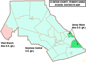
Public School Districts
- Jersey Shore Area School DistrictJersey Shore Area School DistrictThe Jersey Shore Area School District is a public school district in Lycoming County, Pennsylvania and Clinton County, Pennsylvania. It is centered on the borough of Jersey Shore and serves the surrounding Lycoming County municipalities of Limestone Township, Bastress Township, Nippenose Township,...
(also in Lycoming County) - Keystone Central School DistrictKeystone Central School DistrictThe Keystone Central School District is a school district based in Lock Haven, Pennsylvania that includes public schools in Clinton County, and that serves students in Clinton County, Centre County, and Potter County...
(also in Centre County) - West Branch Area School DistrictWest Branch Area School DistrictThe West Branch Area School District is located in Morrisdale, Pennsylvania. It was created in 1958 by the joining of Cooper Township High School and Morris Township High School. Schools in the district include West Branch Area Elementary School and West Branch Area Junior/Senior High School. Both...
(also in Clearfield County)
Recreation
There are five Pennsylvania state parks in Clinton County.- Bucktail State Park Natural AreaBucktail State Park Natural AreaBucktail State Park Natural Area is a Pennsylvania state park in Cameron and Clinton Counties in Pennsylvania in the United States. The park follows Pennsylvania Route 120 for between Emporium and Lock Haven...
is a 75 miles (120.7 km) scenic route along Pennsylvania Route 120Pennsylvania Route 120Pennsylvania Route 120 is a state highway in the U.S. state of Pennsylvania, running from U.S. Route 219 in Ridgway east to U.S. Route 220 in Lock Haven.-Bucktail State Park Natural Area:...
stretching from Lock HavenLock Haven, PennsylvaniaThe city of Lock Haven is the county seat of Clinton County, in the U.S. state of Pennsylvania. Located near the confluence of the West Branch Susquehanna River and Bald Eagle Creek, it is the principal city of the Lock Haven, Pennsylvania, micropolitan statistical area, itself part of the...
to EmporiumEmporium, PennsylvaniaEmporium is a borough in Cameron County, Pennsylvania, west-northwest of Williamsport. Early in the twentieth century, it had large powder plants and manufactories of radio tubes, incandescent lamps, paving brick, flour, iron, lumber, sole leather, etc. In 1900, 2,463 people lived in Emporium, and...
in Cameron CountyCameron County, PennsylvaniaAs of the census of 2000, there were 5,974 people, 2,465 households, and 1,624 families residing in the county. The population density was 15 people per square mile . There were 4,592 housing units at an average density of 12 per square mile...
. - Hyner Run State ParkHyner Run State ParkHyner Run State Park is a Pennsylvania state park in Chapman Township, Clinton County, Pennsylvania in the United States. The park is east of Renovo and 3 miles north of Hyner on Pennsylvania Route 120...
- Hyner View State ParkHyner View State ParkHyner View State Park is a Pennsylvania state park in Chapman Township, Clinton County, Pennsylvania in the United States. The park is east of Renovo and north of Hyner on Pennsylvania Route 120...
- Kettle Creek State ParkKettle Creek State ParkKettle Creek State Park is a Pennsylvania state park in Leidy Township, Clinton County, Pennsylvania in the United States. The park is in a valley and is surrounded by mountains and wilderness. It features the Alvin R. Bush Dam built in 1961 by the U.S. Army Corps of Engineers as a flood control...
- Ravensburg State ParkRavensburg State ParkRavensburg State Park is a Pennsylvania state park in Crawford Township in Clinton County, Pennsylvania in the United States. It is in a gorge carved by Rauchtown Run through the side of Nippenose Mountain. Ravensburg State Park is of wooded land that is almost entirely surrounded by Tiadaghton...
See also
- List of municipal authorities in Clinton County, Pennsylvania
- National Register of Historic Places listings in Clinton County, PennsylvaniaNational Register of Historic Places listings in Clinton County, PennsylvaniaThis is a list of the National Register of Historic Places listings in Clinton County, Pennsylvania.This is intended to be a complete list of the properties and districts on the National Register of Historic Places in Clinton County, Pennsylvania, United States...

