
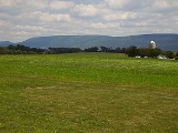
Tussey Mountain
Encyclopedia
Tussey Mountain is a stratigraphic
Stratigraphy
Stratigraphy, a branch of geology, studies rock layers and layering . It is primarily used in the study of sedimentary and layered volcanic rocks....
ridge
Ridge
A ridge is a geological feature consisting of a chain of mountains or hills that form a continuous elevated crest for some distance. Ridges are usually termed hills or mountains as well, depending on size. There are several main types of ridges:...
in central Pennsylvania
Pennsylvania
The Commonwealth of Pennsylvania is a U.S. state that is located in the Northeastern and Mid-Atlantic regions of the United States. The state borders Delaware and Maryland to the south, West Virginia to the southwest, Ohio to the west, New York and Ontario, Canada, to the north, and New Jersey to...
, United States
United States
The United States of America is a federal constitutional republic comprising fifty states and a federal district...
, trending east of the Bald Eagle
Bald Eagle Mountain
Bald Eagle Mountain, once known locally as Muncy Mountain, is a stratigraphic ridge in central Pennsylvania, United States, running east of the Allegheny Front and northwest of Mount Nittany. It lies along the southeast side of Bald Eagle Creek, and south of the West Branch Susquehanna River, and...
, Brush, Dunning and Evitts Mountain
Evitts Mountain
Evitts Mountain is a stratigraphic ridge in the Ridge and Valley region of the Appalachian Mountains, located in Bedford County, Pennsylvania and Allegany County, Maryland-Geography:...
ridges. Its southern foot just crosses the Mason-Dixon Line
Mason-Dixon line
The Mason–Dixon Line was surveyed between 1763 and 1767 by Charles Mason and Jeremiah Dixon in the resolution of a border dispute between British colonies in Colonial America. It forms a demarcation line among four U.S. states, forming part of the borders of Pennsylvania, Maryland, Delaware, and...
near Flintstone, Maryland
Flintstone, Maryland
Flintstone is a small unincorporated town in Allegany County, Maryland, USA. Flintstone lies between the southern foot of Tussey Mountain and a water gap in the Warrior Mountain formed by Flintstone Creek, north of the North Branch Potomac River and south of the Mason-Dixon Line. Rocky Gap State...
, running north 130 km (80 mi) to the Seven Mountains of central Pennsylvania, near Tusseyville
Tusseyville, Pennsylvania
Tusseyville is a small unincorporated community in Centre County, Pennsylvania, United States. It is just north of U.S. Route 322 in Penns Valley near Centre Hall....
, making it one of the longest named ridges in this section of the Ridge-and-valley Appalachians
Ridge-and-valley Appalachians
The Ridge-and-Valley Appalachians, also called the Ridge and Valley Province or the Valley and Ridge Appalachians, are a physiographic province of the larger Appalachian division and are also a belt within the Appalachian Mountains extending from southeastern New York through northwestern New...
. The ridge line separates Morrison Cove
Morrison Cove
Morrisons Cove , is an eroded anticlinal valley in Blair and Bedford counties of central Pennsylvania, United States, extending from Evitts Mountain near New Enterprise, north to the Frankstown Branch Juniata River at Williamsburg...
from the Woodcock Valley and Friends Cove from the Black Valley. Tussey Mountain lies in, and the ridge line forms parts of the borders of, Centre
Centre County, Pennsylvania
Centre County is a county located in the U.S. state of Pennsylvania. It is part of the State College, Pennsylvania Metropolitan Statistical Area. As of 2010, the population was 153,990....
, Blair
Blair County, Pennsylvania
-Significant Topographic Features:*Brush Mountain*Logan Valley*Morrison Cove*Tussey Mountain-Demographics:As of the census of 2000, there were 129,144 people, 51,518 households, and 34,877 families residing in the county. The population density was 246 people per square mile . There were 55,061...
, Bedford
Bedford County, Pennsylvania
Bedford County is a county located in the U.S. state of Pennsylvania. As of the 2010 census, the population was 49,762. The county seat is Bedford. It is part of the Altoona, Pennsylvania, Metropolitan Statistical Area.- History :...
and Huntingdon
Huntingdon County, Pennsylvania
Huntingdon County is a county located in the U.S. state of Pennsylvania. In 2010, its population was 45,913.Huntingdon County was created on September 20, 1787, from part of Bedford County. Its county seat is Huntingdon.-Geography:According to the U.S...
counties.
The Flintstone Creek runs around the southern end of the mountain in Maryland. North of there, small streams run through deep gorges, the Sweet Root and Rainsburg Gaps, near Martin Hill
Martin Hill
Martin Hill is a mountain ridge which connects Tussey Mountain to its east and Evitts Mountain to its west. Martin Hill is located in the Martin Hill Wild Area, which is a part of the Buchanan State Forest, in Bedford County, Pennsylvania...
. At Everett
Everett, Pennsylvania
Everett is a borough in Bedford County, Pennsylvania, United States. The population was 1,905 at the 2000 census.Everett's original name was Bloody Run, after a creek which was the site of a battle between settlers and Native Americans...
the Pennsylvania Turnpike
Pennsylvania Turnpike
The Pennsylvania Turnpike is a toll highway system operated by the Pennsylvania Turnpike Commission in the Commonwealth of Pennsylvania, United States. The three sections of the turnpike system total . The main section extends from Ohio to New Jersey and is long...
, U.S. Route 30
U.S. Route 30
U.S. Route 30 is an east–west main route of the system of United States Numbered Highways, with the highway traveling across the northern tier of the country. It is the third longest U.S. route, after U.S. Route 20 and U.S. Route 6. The western end of the highway is at Astoria, Oregon; the...
, and the abandoned Huntingdon and Broad Top Mountain Railroad
Huntingdon and Broad Top Mountain Railroad
Huntington & Broad Top Mountain Railroad is a former short line railroad company operating passenger and freight service on standard gauge track in south central Pennsylvania....
follow the Raystown Branch Juniata River
Raystown Branch Juniata River
The Raystown Branch Juniata River is the largest and longest tributary of the Juniata River in south-central Pennsylvania in the United States....
through a deep water gap
Water gap
A water gap is an opening or notch which flowing water has carved through a mountain range. Water gaps often offer a practical route for road and rail transport to cross mountain ridges.- Geology :...
. The Yellow Creek runs through Loysburg Gap at Loysburg, Pennsylvania
Loysburg, Pennsylvania
Loysburg is an unincorporated community in the Morrisons Cove area of South Woodbury Township, Bedford County, Pennsylvania, United States. It lies along Pennsylvania Route 36 and the Yellow Creek near the Loysburg Gap in Tussey Mountain...
. Maple Run Road passes through a wind gap
Wind gap
A wind gap is a valley through which a waterway once flowed, but is now dry as a result of stream capture. A water gap is a similar feature, but one in which a waterway still flows...
near Pulpit Hill and Coot Hill, heading west to Woodbury
Woodbury, Pennsylvania
Woodbury in Morrison Cove, is a borough in Bedford County, Pennsylvania, United States. The population was 269 at the 2000 census.-Geography:Woodbury is located at ....
. Pennsylvania Route 164 runs east out of Martinsburg
Martinsburg, Pennsylvania
Martinsburg, in Morrisons Cove, is a borough in Blair County, Pennsylvania, United States. The population was 2,236 at the 2000 census. It is part of the Altoona, PA Metropolitan Statistical Area.-Geography:Martinsburg is located at ....
, and climbs the west slope with a switchback before crossing the crest. The Frankstown Branch Juniata River
Frankstown Branch Juniata River
The Frankstown Branch Juniata River is a tributary of the Juniata River in Blair County, Pennsylvania, in the United States.The headwater tributaries of the Frankstown Branch rise on the slopes of the Allegheny Front south of Altoona...
runs north along the west foot of the ridge before turning east along U.S. Route 22
U.S. Route 22
U.S. Route 22 is a west–east route and is one of the original United States highways of 1926, running from Cincinnati, Ohio, at US 27, US 42, US 127, and US 52 to Newark, New Jersey, at U.S. Route 1/9 near the Newark Liberty International Airport.US 22 also carries the names of the William...
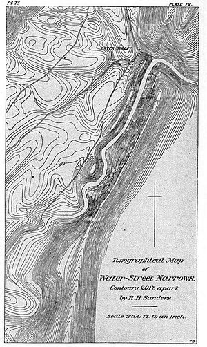
at Water Street
Water Street, Pennsylvania
Water Street is a small unincorporated village in the Canoe Valley of Morris Township, part of Huntingdon County, Pennsylvania, United States. The Frankstown Branch Juniata River runs north along the west foot of the Tussey Mountain ridge to the village, before turning east along U.S. Route 22,...
, the river, road, and rail (abandoned PRR Petersburg Branch) crossing the ridge line through a water gap. The Little Juniata River
Little Juniata River
]The Little Juniata River, sometimes called the "Little J," is a river in central Pennsylvania. It is a tributary of the Juniata River in the Susquehanna River watershed. It is formed at Altoona by the confluence of several short streams...
passes through a nearby water gap at Spruce Creek
Spruce Creek, Pennsylvania
Spruce Creek is a small unincorporated community in Spruce Creek Township of Huntingdon County, Pennsylvania, United States. It was a stop on the former Pennsylvania Railroad Main Line, lying along Spruce Creek at its confluence with the Little Juniata River...
along with the former Pennsylvania Railroad Main Line
Main Line (Pennsylvania Railroad)
The Main Line of the Pennsylvania Railroad was a rail line in the U.S. state of Pennsylvania, connecting Philadelphia with Pittsburgh via Harrisburg...
, which tunnels through a spur of the mountain to cut across a loop in the river. Galbraith Run passes through Galbraith Gap near the north end of the ridge, adjacent to the Tussey Mountain Ski Area
Tussey Mountain Ski Area
The Tussey Mountain Ski Area is located in Boalsburg, Centre County, Pennsylvania on the Tussey Mountain. Tussey Mountain Ski Area offers discounted rates for students of Penn State University. Tussey has 9 trails, with the longest one being about 3/4 of a mile. However, many of the trails exist...
in Boalsburg
Boalsburg, Pennsylvania
Boalsburg is a census-designated place in Centre County, Pennsylvania, United States. It is part of the State College, Pennsylvania Metropolitan Statistical Area. The population was 3,578 at the 2000 census. The village claims to be the birthplace of Memorial Day. The name Boalsburg comes from...
.
The Tussey Mountain Ridge is popular with soaring birds and glider
Glider (sailplane)
A glider or sailplane is a type of glider aircraft used in the sport of gliding. Some gliders, known as motor gliders are used for gliding and soaring as well, but have engines which can, in some cases, be used for take-off or for extending a flight...
pilots ridge soaring along its slopes. This ridge is part of a chain of ridges that stretch south to Tennessee
Tennessee
Tennessee is a U.S. state located in the Southeastern United States. It has a population of 6,346,105, making it the nation's 17th-largest state by population, and covers , making it the 36th-largest by total land area...
. Tussey Mountain has been designated a Pennsylvania Important Bird Area
Important Bird Area
An Important Bird Area is an area recognized as being globally important habitat for the conservation of bird populations. Currently there are about 10,000 IBAs worldwide. The program was developed and sites are identified by BirdLife International...
(IBA), based primarily on its importance as a spring raptor migration site, but also as a long corridor of intact forest habitat, over 50% of which is publicly owned http://www.users.fast.net/~aquilac/tussey. It is one of the best sites in the eastern United States for viewing the migration of the golden eagle
Golden Eagle
The Golden Eagle is one of the best known birds of prey in the Northern Hemisphere. Like all eagles, it belongs to the family Accipitridae. Once widespread across the Holarctic, it has disappeared from many of the more heavily populated areas...
. Pennsylvania's longest footpath, Mid State Trail, is atop or closely parallels Tussey Mountain for nearly its entire length.
In Blair County, Tussey Mountain is sometimes called Huntingdon Mountain, as one reaches Huntingdon by crossing it going east. Conversely, in some parts of Huntingdon County it is called Williamsburg Mountain
Williamsburg Mountain
Williamburg Mountain is actually a high "S" bend in the 150 mile long, Tussey Mountain ridge.The mountain was named after the town of Williamsburg, and is actually a local reference which does not show up on USGS maps. This mountain is also referred to as "The Loop" because of its unique shape...
as one reaches Williamsburg by crossing it going west.
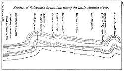
Geology
Appalachian Mountains
The Appalachian Mountains #Whether the stressed vowel is or ,#Whether the "ch" is pronounced as a fricative or an affricate , and#Whether the final vowel is the monophthong or the diphthong .), often called the Appalachians, are a system of mountains in eastern North America. The Appalachians...
. Brush Mountain, Mount Nittany
Mount Nittany
Mount Nittany is the common name for Nittany Mountain, a prominent geographic feature in Centre County, Pennsylvania. The mountain is actually part of a complex of ridges that separates Nittany Valley from Penns Valley, with the enclosed Sugar Valley between them...
and Bald Eagle Mountain
Bald Eagle Mountain
Bald Eagle Mountain, once known locally as Muncy Mountain, is a stratigraphic ridge in central Pennsylvania, United States, running east of the Allegheny Front and northwest of Mount Nittany. It lies along the southeast side of Bald Eagle Creek, and south of the West Branch Susquehanna River, and...
ridges, are part of the same Paleozoic
Paleozoic
The Paleozoic era is the earliest of three geologic eras of the Phanerozoic eon, spanning from roughly...
anticline
Anticline
In structural geology, an anticline is a fold that is convex up and has its oldest beds at its core. The term is not to be confused with antiform, which is a purely descriptive term for any fold that is convex up. Therefore if age relationships In structural geology, an anticline is a fold that is...
rock formation consisting of older Ordovicial
Ordovician
The Ordovician is a geologic period and system, the second of six of the Paleozoic Era, and covers the time between 488.3±1.7 to 443.7±1.5 million years ago . It follows the Cambrian Period and is followed by the Silurian Period...
Bald Eagle Formation
Bald Eagle Formation
The Ordovician Bald Eagle Formation is a mapped bedrock unit in central Pennsylvania, USA. It is a ridge-forming unit in the Appalachian Mountains.-Description:...
Sandstone
Sandstone
Sandstone is a sedimentary rock composed mainly of sand-sized minerals or rock grains.Most sandstone is composed of quartz and/or feldspar because these are the most common minerals in the Earth's crust. Like sand, sandstone may be any colour, but the most common colours are tan, brown, yellow,...
and Juniata Formation
Juniata Formation
The Ordovician Juniata Formation is a mapped bedrock unit in Pennsylvania and Maryland. It is a relative slope-former occurring between the two prominent ridge-forming sandstone units: the Tuscarora Formation and the Bald Eagle Formation in the Appalachian Mountains.-Description:The Juniata is...
Shale
Shale
Shale is a fine-grained, clastic sedimentary rock composed of mud that is a mix of flakes of clay minerals and tiny fragments of other minerals, especially quartz and calcite. The ratio of clay to other minerals is variable. Shale is characterized by breaks along thin laminae or parallel layering...
, and younger Silurian
Silurian
The Silurian is a geologic period and system that extends from the end of the Ordovician Period, about 443.7 ± 1.5 Mya , to the beginning of the Devonian Period, about 416.0 ± 2.8 Mya . As with other geologic periods, the rock beds that define the period's start and end are well identified, but the...
Tuscarora Formation
Tuscarora Formation
The Silurian Tuscarora Formation — also known as Tuscarora Sandstone or Tuscarora Quartzite — is a mapped bedrock unit in Pennsylvania, Maryland, West Virginia, and Virginia.-Description:...
Quartzite
Quartzite
Quartzite is a hard metamorphic rock which was originally sandstone. Sandstone is converted into quartzite through heating and pressure usually related to tectonic compression within orogenic belts. Pure quartzite is usually white to gray, though quartzites often occur in various shades of pink...
. During the Appalachian orogeny, these layers folded
Fold (geology)
The term fold is used in geology when one or a stack of originally flat and planar surfaces, such as sedimentary strata, are bent or curved as a result of permanent deformation. Synsedimentary folds are those due to slumping of sedimentary material before it is lithified. Folds in rocks vary in...
up with the underlying and overlying layers into the Nittany Arch. The arch was a Himalayan
Himalayas
The Himalaya Range or Himalaya Mountains Sanskrit: Devanagari: हिमालय, literally "abode of snow"), usually called the Himalayas or Himalaya for short, is a mountain range in Asia, separating the Indian subcontinent from the Tibetan Plateau...
scale mountain that towered above what is now Nittany Valley
Nittany Valley
The Nittany Valley is an eroded anticlinal valley in the central portion of Centre County, Pennsylvania in the United States. It is separated from the Bald Eagle Valley by Bald Eagle Mountain and from Penns Valley by Mount Nittany. The valley is closed to the north by a high plateau that joins...
, where the oldest rock layers from deep within the eroded
Erosion
Erosion is when materials are removed from the surface and changed into something else. It only works by hydraulic actions and transport of solids in the natural environment, and leads to the deposition of these materials elsewhere...
mountain are now exposed.
The Tuscarora Quartzite is more resistant to erosion than Bald Eagle Sandstone, and both are more durable than the Juniata Shale sandwiched in-between. Softer rock layers on either side of these eroded, leaving the double crested Tussey Mountain ridge, with a depression between the higher eastern and lower western ridge lines found on the northern section of the ridge. Since the rock layers on these ridges slope down to the east, the Tuscarora Formation underlies the higher crest, where it protected the east slope from erosion. Drainage from the upper slope has cut a series of small ravines in the lower ridge line, leaving a terraced lower slope in the Bald Eagle Formation. On the neighboring Bald Eagle, Brush, and Dunning Mountain ridges to the west that formed the opposite side of the ancient mountain, the same three rock layers are exposed in reverse order, with the oldest rocks in-between, near the hinge of the fold http://www.libraries.psu.edu/emsl/guides/X/centre.htm.