

Tuscarora Formation
Encyclopedia
The Silurian
Tuscarora Formation — also known as Tuscarora Sandstone or Tuscarora Quartzite — is a mapped bedrock
unit in Pennsylvania
, Maryland
, West Virginia
, and Virginia
.
, siltstone
and shale
, cross-stratified and conglomeratic conglomerate
in parts, containing a few shale
interbeds.
There is one named member of this formation: Castanea, occurring at the top, leaving the Lower and Middle Tuscarora Formation at the bottom. This formation has been called the "White Medina Sandstone" in West Virginia.
The Tuscarora is a lateral equivalent of the Minsi and Weiders members of the Shawangunk Formation
in eastern Pennsylvania
, New Jersey
, and New York
, and of the Massanutten Formation
, a sandstone in Virginia
. The Tuscarora and its lateral equivalents are the primary ridge-formers of the Ridge-and-Valley Appalachians
in the eastern United States
It is typically 935 feet thick in Pennsylvania, and in Maryland varies from 60 feet to 400 feet thick from east to west.
of the Tuscarora has always been interpreted as mostly terrestrial or shallow marine deposits resulting in a molasse
sequence produced by the Taconic orogeny
. It is thought to represent a vast sand shoal along the margin of the Iapetus Ocean
.
Ripple marks
are seldom found, but do support interpretation as a shallow marine depositional environment.
period, being deposited between 440 to 417 (±10) million years ago. It rests conformably atop the Juniata Formation
and conformably below the Clinton Group
in Pennsylvania
.
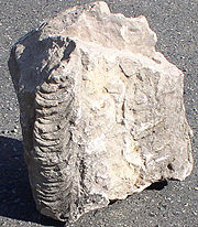 Very few fossils exist in the Tuscarora, and most of them are trace fossils.
At least two hughmilleriid Eurypterid
s have been discovered in the Tuscarora.
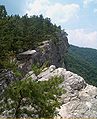 The Tuscarora Formation is commonly exposed on various ridge crests and in many water gap
s in the Ridge and Valley physiographic province
of the Appalachians
of Pennsylvania, Maryland, and West Virginia, particularly along the Wills Mountain Anticline.
In Pennsylvania, the Tuscarora is exposed along U.S. 30 on the north and south sides of the Narrows
in central Bedford County
, where it is nearly vertical.
In Maryland, the National Road (U.S. 40) passes arched Tuscarora sandstone outcrops in the Cumberland Narrows
in Allegany County
.
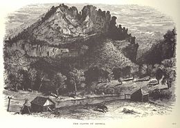
In West Virginia, the River Knobs
along the North Fork of the South Branch of the Potomac River in Pendleton County
include dramatic outcrops of nearly vertical Tuscarora sandstone. Some of the better known of these exposures are Seneca Rocks
, Champe Rocks
, Judy Rocks
, and Nelson Rocks
. These cliffs are clearly visible along U.S. Route 33
and West Virginia highways 28 and 55. North Fork Mountain
, to the east of the River Knobs, is a long Ridge and Valley anticline
ridge capped by Tuscarora sandstone.
Two of the most complete exposures of the Tuscarora Formation are in two quarries at the crest and south end of Canoe Mountain (Frankstown Quadrangle).
for making furnace liners in 19th century iron
smelting
blast furnace
s of central Pennsylvania.
 The Tuscarora has become very important to the tourism industry of eastern West Virginia, where the formation has many conspicuous outcrops visible from such roads as U.S. routes 33
and 50
and West Virginia routes 28 and 55. Tuscarora-capped North Fork Mountain
and various Tuscarora cliffs are prominent in scenic views from such sites as Spruce Knob
and Dolly Sods.
Seneca Rocks
in Pendleton County, West Virginia
, has become a world-renowned rock climbing
location. It is the only "true peak" (a peak inaccessible except by technical rock climbing
techniques) on the East Coast of the United States. Two climbing schools near the outcrop and many other guide services offer guided climbing trips on the 300+ climbing routes on the west-facing cliff. Seneca Rocks
is managed by the U.S. Forest Service, and is located within the Spruce Knob-Seneca Rocks National Recreation Area
of the Monongahela National Forest
.
The Nelson Rocks Preserve
, located near near Circleville, West Virginia
, is a privately owned and operated nature preserve dedicated to preserving Nelson Rocks and the surrounding environment as a cultural, educational, and recreational resource. The preserve offers a via ferrata
climbing trail, one of six in the United States.
Silurian
The Silurian is a geologic period and system that extends from the end of the Ordovician Period, about 443.7 ± 1.5 Mya , to the beginning of the Devonian Period, about 416.0 ± 2.8 Mya . As with other geologic periods, the rock beds that define the period's start and end are well identified, but the...
Tuscarora Formation — also known as Tuscarora Sandstone or Tuscarora Quartzite — is a mapped bedrock
Bedrock
In stratigraphy, bedrock is the native consolidated rock underlying the surface of a terrestrial planet, usually the Earth. Above the bedrock is usually an area of broken and weathered unconsolidated rock in the basal subsoil...
unit in Pennsylvania
Pennsylvania
The Commonwealth of Pennsylvania is a U.S. state that is located in the Northeastern and Mid-Atlantic regions of the United States. The state borders Delaware and Maryland to the south, West Virginia to the southwest, Ohio to the west, New York and Ontario, Canada, to the north, and New Jersey to...
, Maryland
Maryland
Maryland is a U.S. state located in the Mid Atlantic region of the United States, bordering Virginia, West Virginia, and the District of Columbia to its south and west; Pennsylvania to its north; and Delaware to its east...
, West Virginia
West Virginia
West Virginia is a state in the Appalachian and Southeastern regions of the United States, bordered by Virginia to the southeast, Kentucky to the southwest, Ohio to the northwest, Pennsylvania to the northeast and Maryland to the east...
, and Virginia
Virginia
The Commonwealth of Virginia , is a U.S. state on the Atlantic Coast of the Southern United States. Virginia is nicknamed the "Old Dominion" and sometimes the "Mother of Presidents" after the eight U.S. presidents born there...
.
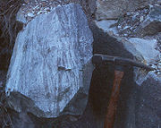
Description
The Tuscarora is a thin- to thick-bedded fine-grained to coarse-grained orthoquartzite. It is a white to medium-gray or gray-green subgraywacke, sandstoneSandstone
Sandstone is a sedimentary rock composed mainly of sand-sized minerals or rock grains.Most sandstone is composed of quartz and/or feldspar because these are the most common minerals in the Earth's crust. Like sand, sandstone may be any colour, but the most common colours are tan, brown, yellow,...
, siltstone
Siltstone
Siltstone is a sedimentary rock which has a grain size in the silt range, finer than sandstone and coarser than claystones.- Description :As its name implies, it is primarily composed of silt sized particles, defined as grains 1/16 - 1/256 mm or 4 to 8 on the Krumbein phi scale...
and shale
Shale
Shale is a fine-grained, clastic sedimentary rock composed of mud that is a mix of flakes of clay minerals and tiny fragments of other minerals, especially quartz and calcite. The ratio of clay to other minerals is variable. Shale is characterized by breaks along thin laminae or parallel layering...
, cross-stratified and conglomeratic conglomerate
Conglomerate (geology)
A conglomerate is a rock consisting of individual clasts within a finer-grained matrix that have become cemented together. Conglomerates are sedimentary rocks consisting of rounded fragments and are thus differentiated from breccias, which consist of angular clasts...
in parts, containing a few shale
Shale
Shale is a fine-grained, clastic sedimentary rock composed of mud that is a mix of flakes of clay minerals and tiny fragments of other minerals, especially quartz and calcite. The ratio of clay to other minerals is variable. Shale is characterized by breaks along thin laminae or parallel layering...
interbeds.
There is one named member of this formation: Castanea, occurring at the top, leaving the Lower and Middle Tuscarora Formation at the bottom. This formation has been called the "White Medina Sandstone" in West Virginia.
The Tuscarora is a lateral equivalent of the Minsi and Weiders members of the Shawangunk Formation
Shawangunk Formation
The Silurian Shawangunk Formation is a mapped bedrock unit in eastern Pennsylvania, New Jersey, and New York. It is named for the Shawangunk Ridge for which it is the dominant rock type. The division of the Shawangunk between the Tuscarora Formation and Clinton Group has not been conclusively...
in eastern Pennsylvania
Pennsylvania
The Commonwealth of Pennsylvania is a U.S. state that is located in the Northeastern and Mid-Atlantic regions of the United States. The state borders Delaware and Maryland to the south, West Virginia to the southwest, Ohio to the west, New York and Ontario, Canada, to the north, and New Jersey to...
, New Jersey
New Jersey
New Jersey is a state in the Northeastern and Middle Atlantic regions of the United States. , its population was 8,791,894. It is bordered on the north and east by the state of New York, on the southeast and south by the Atlantic Ocean, on the west by Pennsylvania and on the southwest by Delaware...
, and New York
New York
New York is a state in the Northeastern region of the United States. It is the nation's third most populous state. New York is bordered by New Jersey and Pennsylvania to the south, and by Connecticut, Massachusetts and Vermont to the east...
, and of the Massanutten Formation
Massanutten Mountain
Massanutten Mountain is a synclinal ridge in the Ridge-and-Valley Appalachians, located in the U.S. state of Virginia.-Geography:The mountain bisects the Shenandoah Valley just east of Strasburg in Shenandoah County in the north, to its highest peak east of Harrisonburg in Rockingham County in the...
, a sandstone in Virginia
Virginia
The Commonwealth of Virginia , is a U.S. state on the Atlantic Coast of the Southern United States. Virginia is nicknamed the "Old Dominion" and sometimes the "Mother of Presidents" after the eight U.S. presidents born there...
. The Tuscarora and its lateral equivalents are the primary ridge-formers of the Ridge-and-Valley Appalachians
Ridge-and-valley Appalachians
The Ridge-and-Valley Appalachians, also called the Ridge and Valley Province or the Valley and Ridge Appalachians, are a physiographic province of the larger Appalachian division and are also a belt within the Appalachian Mountains extending from southeastern New York through northwestern New...
in the eastern United States
United States
The United States of America is a federal constitutional republic comprising fifty states and a federal district...
It is typically 935 feet thick in Pennsylvania, and in Maryland varies from 60 feet to 400 feet thick from east to west.
Depositional environment
The depositional environmentSedimentary depositional environment
In geology, sedimentary depositional environment describes the combination of physical, chemical and biological processes associated with the deposition of a particular type of sediment and, therefore, the rock types that will be formed after lithification, if the sediment is preserved in the rock...
of the Tuscarora has always been interpreted as mostly terrestrial or shallow marine deposits resulting in a molasse
Molasse
The term "molasse" refers to the sandstones, shales and conglomerates formed as terrestrial or shallow marine deposits in front of rising mountain chains. The molasse is deposited in a foreland basin, especially on top of flysch, for example that left from the rising Alps, or erosion in the Himalaya...
sequence produced by the Taconic orogeny
Taconic orogeny
The Taconic orogeny was a mountain building period that ended 440 million years ago and affected most of modern-day New England. A great mountain chain formed from eastern Canada down through what is now the Piedmont of the East coast of the United States...
. It is thought to represent a vast sand shoal along the margin of the Iapetus Ocean
Iapetus Ocean
The Iapetus Ocean was an ocean that existed in the Neoproterozoic and Paleozoic eras of the geologic timescale . The Iapetus Ocean was situated in the southern hemisphere, between the paleocontinents of Laurentia, Baltica and Avalonia...
.
Ripple marks
Ripple marks
In geology, ripple marks are sedimentary structures and indicate agitation by water or wind.- Defining ripple cross-laminae and asymmetric ripples :...
are seldom found, but do support interpretation as a shallow marine depositional environment.
Age
Relative age dating of the Tuscarora places it in the Lower SilurianSilurian
The Silurian is a geologic period and system that extends from the end of the Ordovician Period, about 443.7 ± 1.5 Mya , to the beginning of the Devonian Period, about 416.0 ± 2.8 Mya . As with other geologic periods, the rock beds that define the period's start and end are well identified, but the...
period, being deposited between 440 to 417 (±10) million years ago. It rests conformably atop the Juniata Formation
Juniata Formation
The Ordovician Juniata Formation is a mapped bedrock unit in Pennsylvania and Maryland. It is a relative slope-former occurring between the two prominent ridge-forming sandstone units: the Tuscarora Formation and the Bald Eagle Formation in the Appalachian Mountains.-Description:The Juniata is...
and conformably below the Clinton Group
Clinton Group
The Silurian Clinton Group is a mapped bedrock unit in New York, Pennsylvania, Maryland, and West Virginia. It contains the Rochester Shale, Rose Hill Formation and the ridge-forming Keefer Formation...
in Pennsylvania
Pennsylvania
The Commonwealth of Pennsylvania is a U.S. state that is located in the Northeastern and Mid-Atlantic regions of the United States. The state borders Delaware and Maryland to the south, West Virginia to the southwest, Ohio to the west, New York and Ontario, Canada, to the north, and New Jersey to...
.
Fossils
At least two hughmilleriid Eurypterid
Eurypterid
Eurypterids are an extinct group of arthropods related to arachnids which include the largest known arthropods that ever lived. They are members of the extinct order Eurypterida ; which is the most diverse Paleozoic chelicerate order in terms of species...
s have been discovered in the Tuscarora.
Notable Exposures
Water gap
A water gap is an opening or notch which flowing water has carved through a mountain range. Water gaps often offer a practical route for road and rail transport to cross mountain ridges.- Geology :...
s in the Ridge and Valley physiographic province
Physiographic province
A physiographic province is a geographic region with a specific geomorphology and often specific subsurface rock type or structural elements.A continent may be subdivided into various physiographic provinces, each having a specific character, relief, and environment which contributes to its...
of the Appalachians
Appalachian Mountains
The Appalachian Mountains #Whether the stressed vowel is or ,#Whether the "ch" is pronounced as a fricative or an affricate , and#Whether the final vowel is the monophthong or the diphthong .), often called the Appalachians, are a system of mountains in eastern North America. The Appalachians...
of Pennsylvania, Maryland, and West Virginia, particularly along the Wills Mountain Anticline.
In Pennsylvania, the Tuscarora is exposed along U.S. 30 on the north and south sides of the Narrows
The Narrows (Pennsylvania)
The Narrows is a water gap where the Raystown Branch of the Juniata River passes through Evitts Mountain in Bedford County, Pennsylvania. Both U.S. Route 30 and the Pennsylvania Turnpike pass through the gap...
in central Bedford County
Bedford County, Pennsylvania
Bedford County is a county located in the U.S. state of Pennsylvania. As of the 2010 census, the population was 49,762. The county seat is Bedford. It is part of the Altoona, Pennsylvania, Metropolitan Statistical Area.- History :...
, where it is nearly vertical.
In Maryland, the National Road (U.S. 40) passes arched Tuscarora sandstone outcrops in the Cumberland Narrows
Cumberland Narrows
The Cumberland Narrows is a water gap in western Maryland in the United States, just west of Cumberland, Maryland. Wills Creek cuts through the central ridge of the Wills Mountain Anticline at a low elevation here between Wills Mountain to the north and Haystack Mountain to the south...
in Allegany County
Allegany County, Maryland
Allegany County is a county located in the northwestern part of the US state of Maryland. It is part of the Cumberland, MD-WV Metropolitan Statistical Area. As of 2010, the population was 75,087. Its county seat is Cumberland...
.
In West Virginia, the River Knobs
River Knobs (West Virginia)
For other "River Knobs", see River Knobs .The River Knobs — formerly known as East Seneca Ridge — are a ridge and series of knobs in western Pendleton County, West Virginia, USA, along a stretch of the North Fork South Branch Potomac River...
along the North Fork of the South Branch of the Potomac River in Pendleton County
Pendleton County, West Virginia
As of the census of 2000, there were 8,196 people, 3,350 households, and 2,355 families residing in the county. The population density was 12 people per square mile . There were 5,102 housing units at an average density of 7 per square mile...
include dramatic outcrops of nearly vertical Tuscarora sandstone. Some of the better known of these exposures are Seneca Rocks
Seneca Rocks
Seneca Rocks is a large crag and local landmark in Pendleton County in the Eastern Panhandle of West Virginia, USA. It is easily visible and accessible along West Virginia Route 28 near U.S. Route 33 in the Spruce Knob-Seneca Rocks National Recreation Area of the Monongahela National Forest...
, Champe Rocks
Champe Rocks
Champe Rocks are a pair of large crags in Pendleton County in the Eastern Panhandle of West Virginia, USA. Easily visible from West Virginia Route 28, they are situated within the Spruce Knob-Seneca Rocks National Recreation Area...
, Judy Rocks
Judy Gap, West Virginia
Judy Gap is an unincorporated community in Pendleton County, West Virginia, United States. Judy Gap is located at the junction of U.S. Route 33 and West Virginia Route 28 west-northwest of Franklin, just west of the mountain gap also called Judy Gap. The Judy Rocks geological formation is just to...
, and Nelson Rocks
Nelson Rocks
Nelson Rocks Outdoor Center , previously known as Nelson Rocks Preserve, is an outdoor recreation area located in the North Fork Valley of Pendleton County, West Virginia...
. These cliffs are clearly visible along U.S. Route 33
U.S. Route 33
U.S. Route 33 is a United States federal highway that runs northwest-southeast for 709 miles from northern Indiana to Richmond, Virginia, passing through Ohio and West Virginia en route. Although most odd-numbered U.S...
and West Virginia highways 28 and 55. North Fork Mountain
North Fork Mountain
North Fork Mountain is a quartzite-capped mountain ridge in the Ridge and Valley physiographic province of the Allegheny Mountains of eastern West Virginia, USA...
, to the east of the River Knobs, is a long Ridge and Valley anticline
Anticline
In structural geology, an anticline is a fold that is convex up and has its oldest beds at its core. The term is not to be confused with antiform, which is a purely descriptive term for any fold that is convex up. Therefore if age relationships In structural geology, an anticline is a fold that is...
ridge capped by Tuscarora sandstone.
Two of the most complete exposures of the Tuscarora Formation are in two quarries at the crest and south end of Canoe Mountain (Frankstown Quadrangle).
Economic uses
The Tuscarora may have been used as a ganisterGanister
A ganister is hard, fine-grained quartzose sandstone, or orthoquartzite, used in the manufacture of silica brick typically used to line furnaces...
for making furnace liners in 19th century iron
Iron
Iron is a chemical element with the symbol Fe and atomic number 26. It is a metal in the first transition series. It is the most common element forming the planet Earth as a whole, forming much of Earth's outer and inner core. It is the fourth most common element in the Earth's crust...
smelting
Smelting
Smelting is a form of extractive metallurgy; its main use is to produce a metal from its ore. This includes iron extraction from iron ore, and copper extraction and other base metals from their ores...
blast furnace
Blast furnace
A blast furnace is a type of metallurgical furnace used for smelting to produce industrial metals, generally iron.In a blast furnace, fuel and ore and flux are continuously supplied through the top of the furnace, while air is blown into the bottom of the chamber, so that the chemical reactions...
s of central Pennsylvania.
U.S. Route 33
U.S. Route 33 is a United States federal highway that runs northwest-southeast for 709 miles from northern Indiana to Richmond, Virginia, passing through Ohio and West Virginia en route. Although most odd-numbered U.S...
and 50
U.S. Route 50
U.S. Route 50 is a major east–west route of the U.S. Highway system, stretching just over from Ocean City, Maryland on the Atlantic Ocean to West Sacramento, California. Until 1972, when it was replaced by Interstate Highways west of the Sacramento area, it extended to San Francisco, near...
and West Virginia routes 28 and 55. Tuscarora-capped North Fork Mountain
North Fork Mountain
North Fork Mountain is a quartzite-capped mountain ridge in the Ridge and Valley physiographic province of the Allegheny Mountains of eastern West Virginia, USA...
and various Tuscarora cliffs are prominent in scenic views from such sites as Spruce Knob
Spruce Knob
Spruce Knob, at , is the highest point in the state of West Virginia and the summit of Spruce Mountain, the tallest mountain in the Alleghenies.-Overview:...
and Dolly Sods.
Seneca Rocks
Seneca Rocks
Seneca Rocks is a large crag and local landmark in Pendleton County in the Eastern Panhandle of West Virginia, USA. It is easily visible and accessible along West Virginia Route 28 near U.S. Route 33 in the Spruce Knob-Seneca Rocks National Recreation Area of the Monongahela National Forest...
in Pendleton County, West Virginia
Pendleton County, West Virginia
As of the census of 2000, there were 8,196 people, 3,350 households, and 2,355 families residing in the county. The population density was 12 people per square mile . There were 5,102 housing units at an average density of 7 per square mile...
, has become a world-renowned rock climbing
Rock climbing
Rock climbing also lightly called 'The Gravity Game', is a sport in which participants climb up, down or across natural rock formations or artificial rock walls. The goal is to reach the summit of a formation or the endpoint of a pre-defined route without falling...
location. It is the only "true peak" (a peak inaccessible except by technical rock climbing
Rock climbing
Rock climbing also lightly called 'The Gravity Game', is a sport in which participants climb up, down or across natural rock formations or artificial rock walls. The goal is to reach the summit of a formation or the endpoint of a pre-defined route without falling...
techniques) on the East Coast of the United States. Two climbing schools near the outcrop and many other guide services offer guided climbing trips on the 300+ climbing routes on the west-facing cliff. Seneca Rocks
Seneca Rocks
Seneca Rocks is a large crag and local landmark in Pendleton County in the Eastern Panhandle of West Virginia, USA. It is easily visible and accessible along West Virginia Route 28 near U.S. Route 33 in the Spruce Knob-Seneca Rocks National Recreation Area of the Monongahela National Forest...
is managed by the U.S. Forest Service, and is located within the Spruce Knob-Seneca Rocks National Recreation Area
Spruce Knob-Seneca Rocks National Recreation Area
Spruce Knob-Seneca Rocks National Recreation Area is a U.S. National Recreation Area located within the Monongahela National Forest of eastern West Virginia, USA.The National Recreation Area protects three prominent West Virginia landmarks:...
of the Monongahela National Forest
Monongahela National Forest
The Monongahela National Forest is a national forest located in the Allegheny Mountains of eastern West Virginia, USA. It protects over of federally-owned land within a proclamation boundary that includes much of the Potomac Highlands Region and portions of 10 counties.The MNF includes some...
.
The Nelson Rocks Preserve
Nelson Rocks
Nelson Rocks Outdoor Center , previously known as Nelson Rocks Preserve, is an outdoor recreation area located in the North Fork Valley of Pendleton County, West Virginia...
, located near near Circleville, West Virginia
Circleville, West Virginia
Circleville is an unincorporated community located in Pendleton County, West Virginia, USA. Circleville was named for a Mr. Zirkle who once kept a store here. The old Circleville School is listed on the National Register of Historic Places....
, is a privately owned and operated nature preserve dedicated to preserving Nelson Rocks and the surrounding environment as a cultural, educational, and recreational resource. The preserve offers a via ferrata
Via ferrata
A via ferrata or klettersteig is a mountain route which is equipped with fixed cables, stemples, ladders, and bridges. The use of these allows otherwise isolated routes to be joined to create longer routes which are accessible to people with a wide range of climbing abilities...
climbing trail, one of six in the United States.
See also
- Big Mountain (Pennsylvania)Big Mountain (Pennsylvania)Big Mountain is the high point on the Tuscarora Mountain ridge in south central Pennsylvania in the United States. The . summit is located in the Buchanan State Forest and offers an viewshed that is one of the more stunning in the Commonwealth....
- Bald Eagle MountainBald Eagle MountainBald Eagle Mountain, once known locally as Muncy Mountain, is a stratigraphic ridge in central Pennsylvania, United States, running east of the Allegheny Front and northwest of Mount Nittany. It lies along the southeast side of Bald Eagle Creek, and south of the West Branch Susquehanna River, and...
- Brush Mountain
- Germany ValleyGermany ValleyGermany Valley is a scenic upland valley high in the Allegheny Mountains of eastern West Virginia originally settled by German farmers in the mid-18th Century...
- Geology of PennsylvaniaGeology of PennsylvaniaThe Geology of Pennsylvania consists of six distinct physiographic provinces, three of which are subdivided into different sections. Each province has its own economic advantages and geologic hazards and play an important role in shaping everyday life in the state...
- Massanutten MountainMassanutten MountainMassanutten Mountain is a synclinal ridge in the Ridge-and-Valley Appalachians, located in the U.S. state of Virginia.-Geography:The mountain bisects the Shenandoah Valley just east of Strasburg in Shenandoah County in the north, to its highest peak east of Harrisonburg in Rockingham County in the...
- Mount NittanyMount NittanyMount Nittany is the common name for Nittany Mountain, a prominent geographic feature in Centre County, Pennsylvania. The mountain is actually part of a complex of ridges that separates Nittany Valley from Penns Valley, with the enclosed Sugar Valley between them...
- North Fork MountainNorth Fork MountainNorth Fork Mountain is a quartzite-capped mountain ridge in the Ridge and Valley physiographic province of the Allegheny Mountains of eastern West Virginia, USA...
- Tussey MountainTussey Mountain]Tussey Mountain is a stratigraphic ridge in central Pennsylvania, United States, trending east of the Bald Eagle, Brush, Dunning and Evitts Mountain ridges...
- River Knobs (West Virginia)River Knobs (West Virginia)For other "River Knobs", see River Knobs .The River Knobs — formerly known as East Seneca Ridge — are a ridge and series of knobs in western Pendleton County, West Virginia, USA, along a stretch of the North Fork South Branch Potomac River...
- Seneca RocksSeneca RocksSeneca Rocks is a large crag and local landmark in Pendleton County in the Eastern Panhandle of West Virginia, USA. It is easily visible and accessible along West Virginia Route 28 near U.S. Route 33 in the Spruce Knob-Seneca Rocks National Recreation Area of the Monongahela National Forest...
- Champe RocksChampe RocksChampe Rocks are a pair of large crags in Pendleton County in the Eastern Panhandle of West Virginia, USA. Easily visible from West Virginia Route 28, they are situated within the Spruce Knob-Seneca Rocks National Recreation Area...
- Nelson RocksNelson RocksNelson Rocks Outdoor Center , previously known as Nelson Rocks Preserve, is an outdoor recreation area located in the North Fork Valley of Pendleton County, West Virginia...