
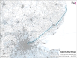
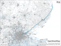
A12 road
Encyclopedia
The A12 is a major road in England. A trunk road
for most of its length it runs from London to Great Yarmouth
in Norfolk
. The road forms part of the unsigned Euroroute
E30
. Unlike most A road
s, the A12 (together with the A14 and the A55) has junction numbers as if it were a motorway.
The 84 km section of the A12 through Essex has sections of dual two lanes and dual three lanes with eight changes in width between the M25 to Ipswich. It was named as Britain's worst road because of "potholes and regular closures due to roadworks" in a 2007 survey by Cornhill Insurance. The A12 is covered by the Highways Agency
A12 and A120 Route Management Strategy.
Starting just north of the Blackwall Tunnel
where it connects end on to the A102
, it heads north through Bow
and Hackney Wick
, then northeast through Leyton
and Romford
, then into Essex
, passing Brentwood
and Colchester
. In Suffolk
, it passes Ipswich
and Saxmundham
, then follows the coast through Lowestoft
before entering Norfolk, passing through Gorleston
and ending at Great Yarmouth.
, and initially the route went from Stratford to Gallows Corner
along the present A118, before continuing to Great Yarmouth; this London section was later amended to follow the current route from Blackwall Tunnel along the East Cross Route
, the M11 link road
(in 1999) and Eastern Avenue (in 1950s).
The route from London to Essex has long been important, with Old Ford being the location of an ancient Celtic crossing of the River Lea. The route was altered slightly by the Romans who created a paved road from London to Colchester
, which was part of Inter V on the Antonine Itinerary
, and parts of this were used by a turnpike road
, the Great Essex Road. The crossing of the Lea moved to its current location at Bow
around 1110 when Matilda, wife of Henry I, ordered a distinctively bow-shaped, three-arched bridge to be built over the river. A map from 1766 shows a route from London to Great Yarmouth which follows much of the current A12.
The "Ipswich to South Town and Bungay Turnpike Trust" was established in 1785, operating between Ipswich and Great Yarmouth. The trust was wound up in 1872 following the arrival of the East Suffolk Line
which was fully operational between the two towns in 1859. Following the demise of the Turnpike trust, responsibility reverted to parish responsibility until the new county councils took over in 1889.
A new section of the A12, known as the "M11 link road" or "A12 Hackney-M11 Link Road", was built in the early 1990s in the face of the major M11 link road protest
and finally opened in October 1999. The section of road had originally been proposed in 1903 in a Royal Commission on London Traffic. A public inquiry had been held in September 1961 and a further three public inquiries, a Parliamentary Bill and a High Court challenge had been required before the work started.
Initiated in 2000, the London to Ipswich Multi-modal study reported its conclusions late in 2002.
In 2008 improvements were made to the junction between the A12 and the M25 to increase slip-road capacity, in particular for clockwise M25 traffic turning north onto the A12, and to ease congestion on the Brook Street Roundabout (serving the M25, A12 and local Brentwood traffic as the A1023).
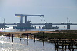
The bascule bridge
in Lowestoft
, built in 1972, was refurbished in spring 2008.
Essex County Council carried out its own inquiry into the road in 2008 (see below for details).
Work on a £12.4m scheme for the a new junction on the A12 at Cuckoo Farm, Colchester
adjacent to the Colchester Community Stadium started in December 2009. It was promoted by Essex County Council who prepared plans in 2001.and received funding from the Community Infrastructure Fund
. It opened on December 16th 2010. See the junction under construction.Aerial photo of construction junction 28 A12
bypass was opened in November 1965.
A bypass for Chelmsford was first included in the roads program in 1968. Draft orders for the southern bypass were published in 1974, however the public inquiry in 1975 suggested that the government should re-examine the appropriateness of a 'central route' and the government delayed the road. In 1979 the government announced that it would proceed with the southern dual two lane route which opened in 1986.
Ipswich's 'Southern by-pass' via the Orwell Bridge
being opened in 1982. This section was later designated as part of the A14.
The Martlesham
bypass (previously known as the Kesgrave
and Martlesham Bypass) was completed in 1987/1988 as was the Saxmundham
bypass.
A White paper
, Roads for Prosperity
, published in 1989, proposed to widen the Chelmsford Bypass and the section from Hatfield Peverel to Witham to dual 3 lane; it also proposed widening to section from Saxmundham to Lowestoft and from Wickham Market to Farnham to dual 2 lanes. It also included a 'new route from the M25 to Chelmsford' as a dual two lane road following the proposed route of the M12 motorway.
The Department for Transport published Trunk roads, England, into the 1990s in May 1990 which included ten proposed developments for the A12 between the M25 and Lowestoft including the M12 motorway between M25 and the Chelmsford bypass, Chelmsford bypass widening and improvements on the sections from Hatfield Peverel to Marks Tey, Four Sisters to Stratford St. Mary, Martlesham to Wickham Market, Wickham Market to Saxmundham, the bypass around Saxmundham, Saxmundham to south of Wrentham, South of Wrentham to Kessingland and the Lowestoft relief road.
A public inquiry in the 'Saxmundham to Wickham Market bypass' was held in 1995 but this road has not been built.
(also known as the South Woodford - Chelmsford Motorway) which would have run from the North Circular at the base of the current M11 motorway joining the A12 south of Chelmsford or at Brentwood. The North Circular was to be upgraded to motorway standard as part of Ringway 2
and be designated as the M15 motorway. The M11 was to have provided a motorway standard road into central London past Ringway 1
terminating at the Angel, Islington
. The M12 motorway was never built, although the junction of the M11 with the north circular was designed to accommodate it.
Plans for the M12 Motorway were withdrawn in March 1994 following a review of the trunk roads program.
at a junction with the A102
and the A13. From here to past Ipswich (including the entire section through London) the road is a dual carriageway
. North of the junction, the A12 heads northwards as a 2/3 lane dual carriageway mostly at street level. This stretch of road is known as the Blackwall Tunnel Northern Approach. This stretch ends at the triple-layer interchange with the A11 at Bow Road where it becomes the East Cross Route
. This is mainly a 3/4 lane dual carriageway built mainly on flyover
s and underpasses and was built in the late 1960s, previously called the A102(M).
The road turns North Eastwards at the unfinished Hackney Wick Interchange where the carriageways split and the northbound carriageway has a right hand entrance. When the London Ringways
plan was being proposed, a motorway (North Cross Route
) was to end here and the M11
was meant to extend from its current terminus on the A406
through this junction and to Angel.
The A12 heads to Lea.
The section from the Lea Interchange to Leytonstone, also known as the M11 Link road, was built in the 1990s in the face of a major road protest
. During this work the old section as far as Wanstead
was rebuilt as a dual carriageway. Prior to that, the A12 started at the Green Man Roundabout at Leytonstone, and was single carriageway west of Wanstead tube station
. It now has an underpass at that roundabout, which again is a junction with the old A11.
East of Wanstead, the A12 runs roughly due east. It is known as Eastern Avenue, then Eastern Avenue West and Eastern Avenue East, built in the 1920s as a bypass for the section of the Roman road
from Colchester
to London running through Ilford
and Romford
(today's A118
). The eastern end of the Eastern Avenue is Gallows Corner
in the London Borough of Havering
, just east of Romford. The junction also marks the start-point of the A127
Southend Arterial Road, also 1920s vintage. At the roundabout, an extemporised two-lane flyover still provides priority for A12 eastbound to A127 traffic (and vice versa). However, the A12 now veers roughly north-eastward, because it starts to follow the course of the Roman road; the Romans started building this road from Colchester, their original capital for the province. However, the 2.5 miles (4 km) stretch from Gallows Corner to the junction with the M25 motorway
, called Colchester Road, is still perfectly straight. The M25 junction is number 28; it also marks where the A12 crosses the boundary from London to Essex.
s. The A12 formerly went through Brentwood
, Mountnessing, Ingatestone
, Margaretting
, Chelmsford
, Boreham
, Hatfield Peverel
, Witham
, Kelvedon
, Copford
, Stanway
and Colchester
, but these are all now bypassed, and the A12 is close to motorway standard for its whole length in Essex.
It is this stretch of the A12, particularly between Chelmsford and Colchester, which has led to the poor reputation for surface quality of the A12. This is mainly for its bumpy or potholed surface, mostly due to worn concrete surfaces. In an ongoing process these sections are being relaid with tarmac, however some sections including the Kelvedon bypass, between Hatfield Peverel and Witham, and between Copford and Stanway have yet to be resurfaced.
Built in 1982, the A12 Colchester bypass provides an uninterrupted dual carriageway where the national speed limit of 70 mph applies. Before 1982, the A12 took a route much closer to Colchester itself, and although still a bypass it consisted of urban single carriageways with roundabouts and pedestrian crossings. The old bypass is still in existence – the western half is now forms part of the A1124 and the eastern half part of the A133.
. When Ipswich's Southern by-pass was built in the early 1980s, the route picked up from the northern Capel St Mary junction (now numbered 32b), to pass to the West of the original line – this allowed the relevant ground works and interchanges to be completed with minimal traffic disruption. The old dual carriageway
through Washbrook and Copdock is blocked off at White's Corner and was renumbered to be the C475. A footpath still exists which enables passage underneath the A14.
 The old route through Ipswich was renumbered as the A1214 following construction of the Ipswich Southern By-pass. The old route is more locally known by the road names, notably "London Road" to the Town Centre and Woodbridge Road out the other side.
The Ipswich Southern By-pass allows the A12 to overlap the A14 to Seven Hills Interchange, 7 miles (11.3 km) from the Copdock junction, where the A12 reappears and heads North.
As the A14 the road passes over the large Orwell Bridge
with total length of 1,287 metres. This has a summit at 43 metres above the river giving a humped feel with reduced visibility for traffic. There are at-grade roundabout junctions past BT Adastral Park at Martlesham
and around the Woodbridge bypass.
For most of its remaining length through Suffolk the A12 is a mostly single carriageway
road and in many places its speed limit is less than the national limit, for example as it passes through towns and villages. During 2003/2004 some of these speed restrictions were further reduced from 40 miles per hour (17.9 m/s) to 30 miles per hour (13.4 m/s). There are, though, a few stretches of dual carriageway between the Woodbridge bypass and Lowestoft (at Wickham Market, Saxmundham, Wangford and Kessingland). This section of the A12 was detrunked in 2001 as part of the Highways Agency's streamlining of its Trunk Road Network. Control was therefore passed to the local authorities. Just south of Blythburgh
, the old milestone
shows it is 100 miles (160.9 km) to London.
 The A12 runs through Lowestoft for about 5 miles (8 km) on urban 30 miles per hour (13.4 m/s) limited roads, however as of June 2006 the A12 now follows the course of the new single carriageway 40 mph Southern Relief Road that joins the original A12 at Lowestoft bascule bridge. A further impediment is the harbour bridge, which has three lanes, the centre lane operating as a one-way addition to whichever direction of flow is deemed greater according to time of day. The presence of these bridge choke points can cause serious disruption to north-south trunk traffic, especially when local traffic is added during rush hours. An adequate bypass for Lowestoft would need to be well to the west, even to the west of Oulton Broad
(the body of water), and its route would have to consider the great areas of marshland in that area. For that reason an often discussed compromise is a third bridge, crossing Lake Lothing, linking the sections of urban spine-road that run approximately along the western edge of Lowestoft.
, northwards to the point where it crosses the River Yare in Great Yarmouth
, the A12 now follows the route originally used by the railway line from Lowestoft to its terminus north of Breydon Bridge at Vauxhall Roundabout where the A47
also terminates.
A bypass for various villages was proposed in 1986 as part of the government's 1989 Roads for Prosperity
white paper
which detailed many road schemes across the country. Suffolk county council considered a bypass for the villages of Farnham
, Stratford St Andrew
, Glemham
and Marlesford
for the 2006 Local Transport Plan. The scheme will not be implemented until after 2016. Essex county council has put forwards plans for a bypass of Chelmsford
connecting Junction 19 of the A12 to the A131. Plans to upgrade the A120
into a dual 2 lane carriageway were scrapped in 2009.
, a former Permanent Secretary at the Department for Transport, with Professor Stephen Glaister
, Dr David Quarmby and Lord Whitty
, all with significant knowledge of the transport sector.
The inquiry began taking submissions in April 2008. The Inquiry, the first ever local authority sponsored inquiry into a major trunk road, heard from 24 organisations and 36 witnesses over three days including Department for Transport
and Highways Agency
officials, MPs, local and regional agencies and authorities, the emergency services, business and motoring groups. Comments were also received from over two hundred members of the public and through a petition organised by the Essex Chronicle
newspaper. The commissions finding were published in July 2008 and its outline recommendations are:
Trunk road
A trunk road, trunk highway, or strategic road is a major road—usually connecting two or more cities, ports, airports, and other things.—which is the recommended route for long-distance and freight traffic...
for most of its length it runs from London to Great Yarmouth
Great Yarmouth
Great Yarmouth, often known to locals as Yarmouth, is a coastal town in Norfolk, England. It is at the mouth of the River Yare, east of Norwich.It has been a seaside resort since 1760, and is the gateway from the Norfolk Broads to the sea...
in Norfolk
Norfolk
Norfolk is a low-lying county in the East of England. It has borders with Lincolnshire to the west, Cambridgeshire to the west and southwest and Suffolk to the south. Its northern and eastern boundaries are the North Sea coast and to the north-west the county is bordered by The Wash. The county...
. The road forms part of the unsigned Euroroute
International E-road network
The international E-road network is a numbering system for roads in Europe developed by the United Nations Economic Commission for Europe . The network is numbered from E 1 up and its roads cross national borders...
E30
European route E30
European route E 30 is an A-Class West-East European route, extending from the southern Irish port of Cork in the west to the Russian city of Omsk in the east...
. Unlike most A road
Great Britain road numbering scheme
The Great Britain road numbering scheme is a numbering scheme used to classify and identify all roads in Great Britain. Each road is given a single letter, which represents the road's category, and a subsequent number, with a length of between 1 and 4 digits. Originally introduced to arrange...
s, the A12 (together with the A14 and the A55) has junction numbers as if it were a motorway.
The 84 km section of the A12 through Essex has sections of dual two lanes and dual three lanes with eight changes in width between the M25 to Ipswich. It was named as Britain's worst road because of "potholes and regular closures due to roadworks" in a 2007 survey by Cornhill Insurance. The A12 is covered by the Highways Agency
Highways Agency
The Highways Agency is an executive agency, part of the Department for Transport in England. It has responsibility for managing the core road network in England...
A12 and A120 Route Management Strategy.
Starting just north of the Blackwall Tunnel
Blackwall Tunnel
The Blackwall Tunnel is a pair of road tunnels underneath the River Thames in east London, linking the London Borough of Tower Hamlets with the London Borough of Greenwich, and part of the A102 road. The northern portal lies just south of the East India Dock Road in Blackwall; the southern...
where it connects end on to the A102
A102 road
The A102 is a road that starts in Clapton in the north London Borough of Hackney and ends in Kidbrooke in the south London Borough of Greenwich. The A102 was formerly a continuous route including two motorway sections classified as the A102 however, subsequent to the renumbering of part of the...
, it heads north through Bow
Bow, London
Bow is an area of London, England, United Kingdom in the London Borough of Tower Hamlets. It is a built-up, mostly residential district located east of Charing Cross, and is a part of the East End.-Bridges at Bowe:...
and Hackney Wick
Hackney Wick
Hackney Wick is an area straddling the boundary between the London Borough of Hackney and the London Borough of Tower Hamlets in east London. It is an inner-city development situated 5 miles northeast of Charing Cross...
, then northeast through Leyton
Leyton
Leyton is an area of north-east London and part of the London Borough of Waltham Forest, located north east of Charing Cross. It borders Walthamstow and Leytonstone; Stratford in Newham; and Homerton and Lower Clapton in the London Borough of Hackney....
and Romford
Romford
Romford is a large suburban town in north east London, England and the administrative headquarters of the London Borough of Havering. It is located northeast of Charing Cross and is one of the major metropolitan centres identified in the London Plan...
, then into Essex
Essex
Essex is a ceremonial and non-metropolitan county in the East region of England, and one of the home counties. It is located to the northeast of Greater London. It borders with Cambridgeshire and Suffolk to the north, Hertfordshire to the west, Kent to the South and London to the south west...
, passing Brentwood
Brentwood, Essex
Brentwood is a town and the principal settlement of the Borough of Brentwood, in the county of Essex in the east of England. It is located in the London commuter belt, 20 miles east north-east of Charing Cross in London, and near the M25 motorway....
and Colchester
Colchester
Colchester is an historic town and the largest settlement within the borough of Colchester in Essex, England.At the time of the census in 2001, it had a population of 104,390. However, the population is rapidly increasing, and has been named as one of Britain's fastest growing towns. As the...
. In Suffolk
Suffolk
Suffolk is a non-metropolitan county of historic origin in East Anglia, England. It has borders with Norfolk to the north, Cambridgeshire to the west and Essex to the south. The North Sea lies to the east...
, it passes Ipswich
Ipswich
Ipswich is a large town and a non-metropolitan district. It is the county town of Suffolk, England. Ipswich is located on the estuary of the River Orwell...
and Saxmundham
Saxmundham
Saxmundham is a small market town in Suffolk, England. It is set in the valley of the River Fromus, a tributary of the River Alde, approximately northeast of Ipswich and west of the coast at Sizewell. The town is bypassed by the A12 and is served by Saxmundham railway station on the East Suffolk...
, then follows the coast through Lowestoft
Lowestoft
Lowestoft is a town in the English county of Suffolk. The town is on the North Sea coast and is the most easterly point of the United Kingdom. It is north-east of London, north-east of Ipswich and south-east of Norwich...
before entering Norfolk, passing through Gorleston
Gorleston
Gorleston-On-Sea, also known colloquially as Gorleston, is a settlement in Norfolk in the United Kingdom, forming part of the larger town of Great Yarmouth. Situated at the mouth of the River Yare it was a port town at the time of the Domesday Book. The port then became a centre of fishing for...
and ending at Great Yarmouth.
History
The A12 was formed in 1922 as part of the Great Britain road numbering schemeGreat Britain road numbering scheme
The Great Britain road numbering scheme is a numbering scheme used to classify and identify all roads in Great Britain. Each road is given a single letter, which represents the road's category, and a subsequent number, with a length of between 1 and 4 digits. Originally introduced to arrange...
, and initially the route went from Stratford to Gallows Corner
Gallows Corner
Gallows Corner is an area and major road junction in the London Borough of Havering near Romford.The junction is a large roundabout with five exits and a flyover...
along the present A118, before continuing to Great Yarmouth; this London section was later amended to follow the current route from Blackwall Tunnel along the East Cross Route
East Cross Route
East Cross Route is a dual-carriageway road constructed in east London as part of the uncompleted Ringway 1 as part of the London Ringways plan drawn up the 1960s to create a series of high speed roads circling and radiating out from central London...
, the M11 link road
M11 link road protest
The M11 link road protest was a major anti-road protest in east London, United Kingdom, in the early 1990s opposing the construction of the "A12 Hackney to M11 link road", also known as the M11 Link Road...
(in 1999) and Eastern Avenue (in 1950s).
The route from London to Essex has long been important, with Old Ford being the location of an ancient Celtic crossing of the River Lea. The route was altered slightly by the Romans who created a paved road from London to Colchester
Colchester
Colchester is an historic town and the largest settlement within the borough of Colchester in Essex, England.At the time of the census in 2001, it had a population of 104,390. However, the population is rapidly increasing, and has been named as one of Britain's fastest growing towns. As the...
, which was part of Inter V on the Antonine Itinerary
Antonine Itinerary
The Antonine Itinerary is a register of the stations and distances along the various roads of the Roman empire, containing directions how to get from one Roman settlement to another...
, and parts of this were used by a turnpike road
Turnpike trust
Turnpike trusts in the United Kingdom were bodies set up by individual Acts of Parliament, with powers to collect road tolls for maintaining the principal highways in Britain from the 17th but especially during the 18th and 19th centuries...
, the Great Essex Road. The crossing of the Lea moved to its current location at Bow
Bow, London
Bow is an area of London, England, United Kingdom in the London Borough of Tower Hamlets. It is a built-up, mostly residential district located east of Charing Cross, and is a part of the East End.-Bridges at Bowe:...
around 1110 when Matilda, wife of Henry I, ordered a distinctively bow-shaped, three-arched bridge to be built over the river. A map from 1766 shows a route from London to Great Yarmouth which follows much of the current A12.
The "Ipswich to South Town and Bungay Turnpike Trust" was established in 1785, operating between Ipswich and Great Yarmouth. The trust was wound up in 1872 following the arrival of the East Suffolk Line
East Suffolk Line
The East Suffolk Line is an un-electrified secondary railway line running between Ipswich and Lowestoft in Suffolk, England. The traffic along the route consists of passenger services operated by National Express East Anglia, while nuclear flask trains for the Sizewell nuclear power stations are...
which was fully operational between the two towns in 1859. Following the demise of the Turnpike trust, responsibility reverted to parish responsibility until the new county councils took over in 1889.
A new section of the A12, known as the "M11 link road" or "A12 Hackney-M11 Link Road", was built in the early 1990s in the face of the major M11 link road protest
M11 link road protest
The M11 link road protest was a major anti-road protest in east London, United Kingdom, in the early 1990s opposing the construction of the "A12 Hackney to M11 link road", also known as the M11 Link Road...
and finally opened in October 1999. The section of road had originally been proposed in 1903 in a Royal Commission on London Traffic. A public inquiry had been held in September 1961 and a further three public inquiries, a Parliamentary Bill and a High Court challenge had been required before the work started.
Initiated in 2000, the London to Ipswich Multi-modal study reported its conclusions late in 2002.
In 2008 improvements were made to the junction between the A12 and the M25 to increase slip-road capacity, in particular for clockwise M25 traffic turning north onto the A12, and to ease congestion on the Brook Street Roundabout (serving the M25, A12 and local Brentwood traffic as the A1023).
The bascule bridge
Bascule bridge
A bascule bridge is a moveable bridge with a counterweight that continuously balances the span, or "leaf," throughout the entire upward swing in providing clearance for boat traffic....
in Lowestoft
Lowestoft
Lowestoft is a town in the English county of Suffolk. The town is on the North Sea coast and is the most easterly point of the United Kingdom. It is north-east of London, north-east of Ipswich and south-east of Norwich...
, built in 1972, was refurbished in spring 2008.
Essex County Council carried out its own inquiry into the road in 2008 (see below for details).
Work on a £12.4m scheme for the a new junction on the A12 at Cuckoo Farm, Colchester
Colchester
Colchester is an historic town and the largest settlement within the borough of Colchester in Essex, England.At the time of the census in 2001, it had a population of 104,390. However, the population is rapidly increasing, and has been named as one of Britain's fastest growing towns. As the...
adjacent to the Colchester Community Stadium started in December 2009. It was promoted by Essex County Council who prepared plans in 2001.and received funding from the Community Infrastructure Fund
Community Infrastructure Fund
Community Infrastructure Fund is a UK government initiative created as a joint venture by the Department for Transport and the Department for Communities and Local Government., it was created following the recommendation of the Barker Review of Housing Supply.CIF was created to fund transport...
. It opened on December 16th 2010. See the junction under construction.Aerial photo of construction junction 28 A12
Bypasses
The 5 miles (8 km) long BrentwoodBrentwood, Essex
Brentwood is a town and the principal settlement of the Borough of Brentwood, in the county of Essex in the east of England. It is located in the London commuter belt, 20 miles east north-east of Charing Cross in London, and near the M25 motorway....
bypass was opened in November 1965.
A bypass for Chelmsford was first included in the roads program in 1968. Draft orders for the southern bypass were published in 1974, however the public inquiry in 1975 suggested that the government should re-examine the appropriateness of a 'central route' and the government delayed the road. In 1979 the government announced that it would proceed with the southern dual two lane route which opened in 1986.
Ipswich's 'Southern by-pass' via the Orwell Bridge
Orwell Bridge
The Orwell Bridge was opened to road traffic in 1982 and carries the A14 over the River Orwell just south of Ipswich in Suffolk, England....
being opened in 1982. This section was later designated as part of the A14.
The Martlesham
Martlesham
Martlesham is a village in Suffolk, England about two miles South-West of Woodbridge and East of Ipswich. It is often referred to as "old Martlesham" by locals in order to distinguish this old village from the much more recent Martlesham Heath development to the south although both form a...
bypass (previously known as the Kesgrave
Kesgrave
Kesgrave is a small town in the English county of Suffolk on the northern edge of Ipswich.-Early history:The town was recorded as Gressgrava in the Domesday Book, by the late 15th century its name had become Kesgrave...
and Martlesham Bypass) was completed in 1987/1988 as was the Saxmundham
Saxmundham
Saxmundham is a small market town in Suffolk, England. It is set in the valley of the River Fromus, a tributary of the River Alde, approximately northeast of Ipswich and west of the coast at Sizewell. The town is bypassed by the A12 and is served by Saxmundham railway station on the East Suffolk...
bypass.
A White paper
White paper
A white paper is an authoritative report or guide that helps solve a problem. White papers are used to educate readers and help people make decisions, and are often requested and used in politics, policy, business, and technical fields. In commercial use, the term has also come to refer to...
, Roads for Prosperity
Roads for Prosperity
Roads for Prosperity was a controversial white paper published by the Conservative UK Government in 1989 detailing the 'largest road building program for the UK since the Romans' produced in response to rapid increases in car ownership and use over the previous decade...
, published in 1989, proposed to widen the Chelmsford Bypass and the section from Hatfield Peverel to Witham to dual 3 lane; it also proposed widening to section from Saxmundham to Lowestoft and from Wickham Market to Farnham to dual 2 lanes. It also included a 'new route from the M25 to Chelmsford' as a dual two lane road following the proposed route of the M12 motorway.
The Department for Transport published Trunk roads, England, into the 1990s in May 1990 which included ten proposed developments for the A12 between the M25 and Lowestoft including the M12 motorway between M25 and the Chelmsford bypass, Chelmsford bypass widening and improvements on the sections from Hatfield Peverel to Marks Tey, Four Sisters to Stratford St. Mary, Martlesham to Wickham Market, Wickham Market to Saxmundham, the bypass around Saxmundham, Saxmundham to south of Wrentham, South of Wrentham to Kessingland and the Lowestoft relief road.
A public inquiry in the 'Saxmundham to Wickham Market bypass' was held in 1995 but this road has not been built.
M12 motorway
During the 1960s there were plans for an M12 motorwayM12 motorway
The M12 motorway was a planned motorway starting in north-east London and joining the A12 road in Essex. The 1960s scheme would have started at a junction with the M11 motorway and North Circular and ended near Brentwood, Chelmsford or at the proposed new Maplin Sands airport; the motorway was part...
(also known as the South Woodford - Chelmsford Motorway) which would have run from the North Circular at the base of the current M11 motorway joining the A12 south of Chelmsford or at Brentwood. The North Circular was to be upgraded to motorway standard as part of Ringway 2
Ringway 2
Ringway 2 was the second innermost of the series of four London Ringways, ring roads planned in the 1960s to circle London at various distances from the city centre...
and be designated as the M15 motorway. The M11 was to have provided a motorway standard road into central London past Ringway 1
Ringway 1
Ringway 1 or the London Motorway Box was the innermost of the series of four motorway standard roads, known as the London Ringways as part of a comprehensive scheme developed by the Greater London Council to provide high speed motorway-standard roads within the capital linking a series of radial...
terminating at the Angel, Islington
Islington
Islington is a neighbourhood in Greater London, England and forms the central district of the London Borough of Islington. It is a district of Inner London, spanning from Islington High Street to Highbury Fields, encompassing the area around the busy Upper Street...
. The M12 motorway was never built, although the junction of the M11 with the north circular was designed to accommodate it.
Plans for the M12 Motorway were withdrawn in March 1994 following a review of the trunk roads program.
Route
| A12 Road | ||
| Northbound exits | Junction | Southbound exits |
| Essex | ||
| M25 M25 motorway The M25 motorway, or London Orbital, is a orbital motorway that almost encircles Greater London, England, in the United Kingdom. The motorway was first mooted early in the 20th century. A few sections, based on the now abandoned London Ringways plan, were constructed in the early 1970s and it ... , Brentwood Brentwood, Essex Brentwood is a town and the principal settlement of the Borough of Brentwood, in the county of Essex in the east of England. It is located in the London commuter belt, 20 miles east north-east of Charing Cross in London, and near the M25 motorway.... A1023 A1023 road The A1023 is an A-road in Essex, England.The road is approximately long and at its western end is an exit from the Brook Street Roundabout .... |
11 (M25 M25 motorway The M25 motorway, or London Orbital, is a orbital motorway that almost encircles Greater London, England, in the United Kingdom. The motorway was first mooted early in the 20th century. A few sections, based on the now abandoned London Ringways plan, were constructed in the early 1970s and it ... J28 - Brook Street) |
M25 M25 motorway The M25 motorway, or London Orbital, is a orbital motorway that almost encircles Greater London, England, in the United Kingdom. The motorway was first mooted early in the 20th century. A few sections, based on the now abandoned London Ringways plan, were constructed in the early 1970s and it ... , Brentwood Brentwood, Essex Brentwood is a town and the principal settlement of the Borough of Brentwood, in the county of Essex in the east of England. It is located in the London commuter belt, 20 miles east north-east of Charing Cross in London, and near the M25 motorway.... A1023 A1023 road The A1023 is an A-road in Essex, England.The road is approximately long and at its western end is an exit from the Brook Street Roundabout .... |
| Brentwood Brentwood, Essex Brentwood is a town and the principal settlement of the Borough of Brentwood, in the county of Essex in the east of England. It is located in the London commuter belt, 20 miles east north-east of Charing Cross in London, and near the M25 motorway.... A1023, Mountnessing B1002 |
12 (Mountnessing Marylands) | Brentwood Brentwood, Essex Brentwood is a town and the principal settlement of the Borough of Brentwood, in the county of Essex in the east of England. It is located in the London commuter belt, 20 miles east north-east of Charing Cross in London, and near the M25 motorway.... A1023, Mountnessing B1002 |
| No Exit | 13 (Trueloves) | Ingatestone Ingatestone Ingatestone is a small town in Essex, England, with a population of about 4500 people. To the immediate north lies the village of Fryerning, and the two form the civil parish of Ingatestone and Fryerning.... B1002 |
| Margaretting | 14 (Furze Hill) | No Exit |
| Chelmsford Chelmsford Chelmsford is the county town of Essex, England and the principal settlement of the borough of Chelmsford. It is located in the London commuter belt, approximately northeast of Charing Cross, London, and approximately the same distance from the once provincial Roman capital at Colchester... A414 A414 road The A414 is a major road in England. It runs from the A41 at a junction west of Hemel Hempstead in Hertfordshire, through the town to junction 8 of the M1 motorway at Buncefield, and running parallel to the M1 until junction 7, heading south of St Albans, east through Hatfield, Hertford, then... , Margaretting Margaretting Margaretting is a small village in the Chelmsford District, in the English county of Essex.- Location :The village is located on the B1002 road approximately four miles from Chelmsford and two miles from the small town of Ingatestone. It is near the River Wid... B1002 |
15 (Webb’s Farm) | Chelmsford Chelmsford Chelmsford is the county town of Essex, England and the principal settlement of the borough of Chelmsford. It is located in the London commuter belt, approximately northeast of Charing Cross, London, and approximately the same distance from the once provincial Roman capital at Colchester... A414 A414 road The A414 is a major road in England. It runs from the A41 at a junction west of Hemel Hempstead in Hertfordshire, through the town to junction 8 of the M1 motorway at Buncefield, and running parallel to the M1 until junction 7, heading south of St Albans, east through Hatfield, Hertford, then... , Margaretting Margaretting Margaretting is a small village in the Chelmsford District, in the English county of Essex.- Location :The village is located on the B1002 road approximately four miles from Chelmsford and two miles from the small town of Ingatestone. It is near the River Wid... B1002 |
| B1007 | 16 (Stock Road) | B1007 |
| A130, Chelmsford Chelmsford Chelmsford is the county town of Essex, England and the principal settlement of the borough of Chelmsford. It is located in the London commuter belt, approximately northeast of Charing Cross, London, and approximately the same distance from the once provincial Roman capital at Colchester... A1114 |
17 (Howe Green) | A130, Chelmsford Chelmsford Chelmsford is the county town of Essex, England and the principal settlement of the borough of Chelmsford. It is located in the London commuter belt, approximately northeast of Charing Cross, London, and approximately the same distance from the once provincial Roman capital at Colchester... A1114 |
| A414 A414 road The A414 is a major road in England. It runs from the A41 at a junction west of Hemel Hempstead in Hertfordshire, through the town to junction 8 of the M1 motorway at Buncefield, and running parallel to the M1 until junction 7, heading south of St Albans, east through Hatfield, Hertford, then... |
18 (Sandon) | A414 A414 road The A414 is a major road in England. It runs from the A41 at a junction west of Hemel Hempstead in Hertfordshire, through the town to junction 8 of the M1 motorway at Buncefield, and running parallel to the M1 until junction 7, heading south of St Albans, east through Hatfield, Hertford, then... |
| No Exit | 19 (Boreham) | Chelmsford Chelmsford Chelmsford is the county town of Essex, England and the principal settlement of the borough of Chelmsford. It is located in the London commuter belt, approximately northeast of Charing Cross, London, and approximately the same distance from the once provincial Roman capital at Colchester... A138 |
| Hatfield Peverel Hatfield Peverel Hatfield Peverel is a large urban village and civil parish in the centre of Essex, England. Its population, including the hamlet of Nounsley, is approximately 5,500 . Hatfield means a 'heathery space in the forest'; Peverel refers to William Peverel, the Norman knight granted lands in the area by... |
20a (Hatfield Peveral South) | No Exit |
| No Exit | 20b (Hatfield Peveral North) | Hatfield Peverel Hatfield Peverel Hatfield Peverel is a large urban village and civil parish in the centre of Essex, England. Its population, including the hamlet of Nounsley, is approximately 5,500 . Hatfield means a 'heathery space in the forest'; Peverel refers to William Peverel, the Norman knight granted lands in the area by... |
| Witham Witham Witham is a town in the county of Essex, in the south east of England with a population of 22,500. It is part of the District of Braintree and is twinned with the town of Waldbröl, Germany. Witham stands between the larger towns of Chelmsford and Colchester... B1389 |
21 (Lynfield Motors) | No Exit |
| No Exit | 22 (Coleman's) | Witham Witham Witham is a town in the county of Essex, in the south east of England with a population of 22,500. It is part of the District of Braintree and is twinned with the town of Waldbröl, Germany. Witham stands between the larger towns of Chelmsford and Colchester... B1389 |
| Kelvedon Kelvedon Kelvedon is a village and civil parish in the Braintree District of Essex in England, near to the town of Witham. It has a population of 3,485.-Origins:... B1024 |
23 (Kelvedon South) | No Exit |
| No Exit | 24 (Kelvedon North) | Kelvedon Kelvedon Kelvedon is a village and civil parish in the Braintree District of Essex in England, near to the town of Witham. It has a population of 3,485.-Origins:... B1024 |
| Braintree Braintree, Essex Braintree is a town of about 42,000 people and the principal settlement of the Braintree district of Essex in the East of England. It is northeast of Chelmsford and west of Colchester on the River Blackwater, A120 road and a branch of the Great Eastern Main Line.Braintree has grown contiguous... , Stansted London Stansted Airport -Cargo:-Statistics:-Infrastructure:-Terminal and satellite buildings:Stansted is the newest passenger airport of all the main London airports. The terminal is an oblong glass building, and is separated in to three areas: Check-in concourse, arrivals and departures... A120 A120 road The A120 is an important trunk road in southern England. It follows the course of Stane Street, a Roman road from Standon, Hertfordshire at its western terminus to Colchester... , B1408 |
25 (Marks Tey) | Braintree Braintree, Essex Braintree is a town of about 42,000 people and the principal settlement of the Braintree district of Essex in the East of England. It is northeast of Chelmsford and west of Colchester on the River Blackwater, A120 road and a branch of the Great Eastern Main Line.Braintree has grown contiguous... , Stansted London Stansted Airport -Cargo:-Statistics:-Infrastructure:-Terminal and satellite buildings:Stansted is the newest passenger airport of all the main London airports. The terminal is an oblong glass building, and is separated in to three areas: Check-in concourse, arrivals and departures... A120 A120 road The A120 is an important trunk road in southern England. It follows the course of Stane Street, a Roman road from Standon, Hertfordshire at its western terminus to Colchester... , B1408 |
| A1124 | 26 (Eight Ash Green) | A1124 |
| Colchester Colchester Colchester is an historic town and the largest settlement within the borough of Colchester in Essex, England.At the time of the census in 2001, it had a population of 104,390. However, the population is rapidly increasing, and has been named as one of Britain's fastest growing towns. As the... A133 |
27 (Spring Lane) | No Exit |
| Colchester (North) Colchester Colchester is an historic town and the largest settlement within the borough of Colchester in Essex, England.At the time of the census in 2001, it had a population of 104,390. However, the population is rapidly increasing, and has been named as one of Britain's fastest growing towns. As the... |
28 (Cuckoo Farm) | Colchester (North) Colchester Colchester is an historic town and the largest settlement within the borough of Colchester in Essex, England.At the time of the census in 2001, it had a population of 104,390. However, the population is rapidly increasing, and has been named as one of Britain's fastest growing towns. As the... |
| Harwich Harwich Harwich is a town in Essex, England and one of the Haven ports, located on the coast with the North Sea to the east. It is in the Tendring district. Nearby places include Felixstowe to the northeast, Ipswich to the northwest, Colchester to the southwest and Clacton-on-Sea to the south... , Clacton Clacton-on-Sea Clacton-on-Sea is the largest town on the Tendring peninsula, in Essex, England and was founded in 1871. It is a seaside resort that attracted many tourists in the summer months between the 1950s and 1970s, but which like many other British sea-side resorts went into decline as a holiday... A120 A120 road The A120 is an important trunk road in southern England. It follows the course of Stane Street, a Roman road from Standon, Hertfordshire at its western terminus to Colchester... , Colchester Colchester Colchester is an historic town and the largest settlement within the borough of Colchester in Essex, England.At the time of the census in 2001, it had a population of 104,390. However, the population is rapidly increasing, and has been named as one of Britain's fastest growing towns. As the... A1232 |
29 (Ardleigh Crown) | Harwich Harwich Harwich is a town in Essex, England and one of the Haven ports, located on the coast with the North Sea to the east. It is in the Tendring district. Nearby places include Felixstowe to the northeast, Ipswich to the northwest, Colchester to the southwest and Clacton-on-Sea to the south... , Clacton Clacton-on-Sea Clacton-on-Sea is the largest town on the Tendring peninsula, in Essex, England and was founded in 1871. It is a seaside resort that attracted many tourists in the summer months between the 1950s and 1970s, but which like many other British sea-side resorts went into decline as a holiday... A120 A120 road The A120 is an important trunk road in southern England. It follows the course of Stane Street, a Roman road from Standon, Hertfordshire at its western terminus to Colchester... , Colchester Colchester Colchester is an historic town and the largest settlement within the borough of Colchester in Essex, England.At the time of the census in 2001, it had a population of 104,390. However, the population is rapidly increasing, and has been named as one of Britain's fastest growing towns. As the... A1232 |
| Suffolk | ||
| B1029 | 30 (Park Lane Birchwood) | B1029 |
| East Bergholt East Bergholt East Bergholt is a village in the south of Suffolk, England, just north of the Essex border. It is "twinned" with the village of Barbizon, France.... |
31 | East Bergholt East Bergholt East Bergholt is a village in the south of Suffolk, England, just north of the Essex border. It is "twinned" with the village of Barbizon, France.... |
| Capel St. Mary Capel St. Mary Capel St. Mary – commonly known as Capel – is a village in Suffolk, England. It is about southwest of Ipswich and from Dedham Vale, a designated Area of Outstanding Natural Beauty.-Early history:... |
32a (Capel St. Mary South) | Capel St. Mary Capel St. Mary Capel St. Mary – commonly known as Capel – is a village in Suffolk, England. It is about southwest of Ipswich and from Dedham Vale, a designated Area of Outstanding Natural Beauty.-Early history:... |
| C475 London Road | 32b (Bentley Longwood) | C475 London Road |
| London, Ipswich Ipswich Ipswich is a large town and a non-metropolitan district. It is the county town of Suffolk, England. Ipswich is located on the estuary of the River Orwell... A14, A1214 |
33 (A14 J55 - Copdock Mill) | End of concurrency with A14 |
London
The A12 starts just north of the Blackwall TunnelBlackwall Tunnel
The Blackwall Tunnel is a pair of road tunnels underneath the River Thames in east London, linking the London Borough of Tower Hamlets with the London Borough of Greenwich, and part of the A102 road. The northern portal lies just south of the East India Dock Road in Blackwall; the southern...
at a junction with the A102
A102 road
The A102 is a road that starts in Clapton in the north London Borough of Hackney and ends in Kidbrooke in the south London Borough of Greenwich. The A102 was formerly a continuous route including two motorway sections classified as the A102 however, subsequent to the renumbering of part of the...
and the A13. From here to past Ipswich (including the entire section through London) the road is a dual carriageway
Dual carriageway
A dual carriageway is a class of highway with two carriageways for traffic travelling in opposite directions separated by a central reservation...
. North of the junction, the A12 heads northwards as a 2/3 lane dual carriageway mostly at street level. This stretch of road is known as the Blackwall Tunnel Northern Approach. This stretch ends at the triple-layer interchange with the A11 at Bow Road where it becomes the East Cross Route
East Cross Route
East Cross Route is a dual-carriageway road constructed in east London as part of the uncompleted Ringway 1 as part of the London Ringways plan drawn up the 1960s to create a series of high speed roads circling and radiating out from central London...
. This is mainly a 3/4 lane dual carriageway built mainly on flyover
Overpass
An overpass is a bridge, road, railway or similar structure that crosses over another road or railway...
s and underpasses and was built in the late 1960s, previously called the A102(M).
The road turns North Eastwards at the unfinished Hackney Wick Interchange where the carriageways split and the northbound carriageway has a right hand entrance. When the London Ringways
London Ringways
The London Ringways were a series of four ring roads planned in the 1960s to circle London at various distances from the city centre. They were part of a comprehensive scheme developed by the Greater London Council to alleviate traffic congestion on the city's road system by providing high speed...
plan was being proposed, a motorway (North Cross Route
North Cross Route
North Cross Route was a planned motorway-standard road which would have formed the northern section of Ringway 1 and would have formed the innermost circuit of the London Ringways network. The six-lane dual carriageway with grade separated junctions to an extended M1 Motorway was planned during...
) was to end here and the M11
M11 motorway
The M11 motorway in England is a major road running approximately north from the North Circular Road in South Woodford in north-east London to the A14, north-west of Cambridge.-Route:...
was meant to extend from its current terminus on the A406
A406 road
The A406 or the North Circular Road is a road which crosses North London, UK, linking West and East London. It, together with the South Circular Road, forms a ring road through the inner part of Outer London...
through this junction and to Angel.
The A12 heads to Lea.
The section from the Lea Interchange to Leytonstone, also known as the M11 Link road, was built in the 1990s in the face of a major road protest
M11 link road protest
The M11 link road protest was a major anti-road protest in east London, United Kingdom, in the early 1990s opposing the construction of the "A12 Hackney to M11 link road", also known as the M11 Link Road...
. During this work the old section as far as Wanstead
Wanstead
Wanstead is a suburban area in the London Borough of Redbridge, North-East London. The main road going through Wanstead is the A12. The name is from the Anglo-Saxon words wænn and stede, meaning "settlement on a small hill"....
was rebuilt as a dual carriageway. Prior to that, the A12 started at the Green Man Roundabout at Leytonstone, and was single carriageway west of Wanstead tube station
Wanstead tube station
Wanstead tube station is a London Underground station in Wanstead, on the Hainault loop of the Central Line. It is in Zone 4.Construction of the station had started in the 1930s, but was delayed by the onset of World War 2. Wanstead was not opened until December 14, 1947...
. It now has an underpass at that roundabout, which again is a junction with the old A11.
East of Wanstead, the A12 runs roughly due east. It is known as Eastern Avenue, then Eastern Avenue West and Eastern Avenue East, built in the 1920s as a bypass for the section of the Roman road
Roman road
The Roman roads were a vital part of the development of the Roman state, from about 500 BC through the expansion during the Roman Republic and the Roman Empire. Roman roads enabled the Romans to move armies and trade goods and to communicate. The Roman road system spanned more than 400,000 km...
from Colchester
Colchester
Colchester is an historic town and the largest settlement within the borough of Colchester in Essex, England.At the time of the census in 2001, it had a population of 104,390. However, the population is rapidly increasing, and has been named as one of Britain's fastest growing towns. As the...
to London running through Ilford
Ilford
Ilford is a large cosmopolitan town in East London, England and the administrative headquarters of the London Borough of Redbridge. It is located northeast of Charing Cross and is one of the major metropolitan centres identified in the London Plan. It forms a significant commercial and retail...
and Romford
Romford
Romford is a large suburban town in north east London, England and the administrative headquarters of the London Borough of Havering. It is located northeast of Charing Cross and is one of the major metropolitan centres identified in the London Plan...
(today's A118
A118 road
The A118 is a road in east London, England which links Bow with Gallows Corner, east of Romford. The section from Stratford to Gallows Corner formed the original route of the A12 until the designation was transferred to the Eastern Avenue soon after the latter opened in 1925...
). The eastern end of the Eastern Avenue is Gallows Corner
Gallows Corner
Gallows Corner is an area and major road junction in the London Borough of Havering near Romford.The junction is a large roundabout with five exits and a flyover...
in the London Borough of Havering
London Borough of Havering
The London Borough of Havering is a London borough in North East London, England and forms part of Outer London. The principal town in Havering is Romford and the other main communities are Hornchurch, Upminster and Rainham. The borough is mainly characterised by suburban development with large...
, just east of Romford. The junction also marks the start-point of the A127
A127 road
The A127, also known as the Southend Arterial Road, is one of the trunk roads in England linking London with Southend-on-Sea, the other being the A13. It is a dual carriageway for its entire length, rare on a trunk road since the only others are the A14 and the A282, and is known as the Southend...
Southend Arterial Road, also 1920s vintage. At the roundabout, an extemporised two-lane flyover still provides priority for A12 eastbound to A127 traffic (and vice versa). However, the A12 now veers roughly north-eastward, because it starts to follow the course of the Roman road; the Romans started building this road from Colchester, their original capital for the province. However, the 2.5 miles (4 km) stretch from Gallows Corner to the junction with the M25 motorway
M25 motorway
The M25 motorway, or London Orbital, is a orbital motorway that almost encircles Greater London, England, in the United Kingdom. The motorway was first mooted early in the 20th century. A few sections, based on the now abandoned London Ringways plan, were constructed in the early 1970s and it ...
, called Colchester Road, is still perfectly straight. The M25 junction is number 28; it also marks where the A12 crosses the boundary from London to Essex.
Essex
Originally, the A12 followed the route of the Roman road closely and so was fairly straight, but there are now several town bypasses, so the road through Essex now has several meanderMeander
A meander in general is a bend in a sinuous watercourse. A meander is formed when the moving water in a stream erodes the outer banks and widens its valley. A stream of any volume may assume a meandering course, alternately eroding sediments from the outside of a bend and depositing them on the...
s. The A12 formerly went through Brentwood
Brentwood, Essex
Brentwood is a town and the principal settlement of the Borough of Brentwood, in the county of Essex in the east of England. It is located in the London commuter belt, 20 miles east north-east of Charing Cross in London, and near the M25 motorway....
, Mountnessing, Ingatestone
Ingatestone
Ingatestone is a small town in Essex, England, with a population of about 4500 people. To the immediate north lies the village of Fryerning, and the two form the civil parish of Ingatestone and Fryerning....
, Margaretting
Margaretting
Margaretting is a small village in the Chelmsford District, in the English county of Essex.- Location :The village is located on the B1002 road approximately four miles from Chelmsford and two miles from the small town of Ingatestone. It is near the River Wid...
, Chelmsford
Chelmsford
Chelmsford is the county town of Essex, England and the principal settlement of the borough of Chelmsford. It is located in the London commuter belt, approximately northeast of Charing Cross, London, and approximately the same distance from the once provincial Roman capital at Colchester...
, Boreham
Boreham
Boreham is a village and civil parish, in Essex, England. It is located approximately northeast from the county town of Chelmsford. The village is in the borough of Chelmsford and parliamentary constituency of Saffron Walden.- History :...
, Hatfield Peverel
Hatfield Peverel
Hatfield Peverel is a large urban village and civil parish in the centre of Essex, England. Its population, including the hamlet of Nounsley, is approximately 5,500 . Hatfield means a 'heathery space in the forest'; Peverel refers to William Peverel, the Norman knight granted lands in the area by...
, Witham
Witham
Witham is a town in the county of Essex, in the south east of England with a population of 22,500. It is part of the District of Braintree and is twinned with the town of Waldbröl, Germany. Witham stands between the larger towns of Chelmsford and Colchester...
, Kelvedon
Kelvedon
Kelvedon is a village and civil parish in the Braintree District of Essex in England, near to the town of Witham. It has a population of 3,485.-Origins:...
, Copford
Copford
Copford is a village and civil parish in Essex, England west of Colchester. The hamlet of Copford Green is found a short distance to the south. The poet Matthew Arnold noted he was struck by "the deeply rural character of the village and neighbourhood."...
, Stanway
Stanway, Essex
Stanway is a village and civil parish in Essex, England located near Colchester. It is now widely referred to as a suburb.Stanway is located approximately three miles west of Colchester town centre on the B1408 , near the junction of the A12 and the A1124 at Eight Ash Green...
and Colchester
Colchester
Colchester is an historic town and the largest settlement within the borough of Colchester in Essex, England.At the time of the census in 2001, it had a population of 104,390. However, the population is rapidly increasing, and has been named as one of Britain's fastest growing towns. As the...
, but these are all now bypassed, and the A12 is close to motorway standard for its whole length in Essex.
It is this stretch of the A12, particularly between Chelmsford and Colchester, which has led to the poor reputation for surface quality of the A12. This is mainly for its bumpy or potholed surface, mostly due to worn concrete surfaces. In an ongoing process these sections are being relaid with tarmac, however some sections including the Kelvedon bypass, between Hatfield Peverel and Witham, and between Copford and Stanway have yet to be resurfaced.
Built in 1982, the A12 Colchester bypass provides an uninterrupted dual carriageway where the national speed limit of 70 mph applies. Before 1982, the A12 took a route much closer to Colchester itself, and although still a bypass it consisted of urban single carriageways with roundabouts and pedestrian crossings. The old bypass is still in existence – the western half is now forms part of the A1124 and the eastern half part of the A133.
Suffolk
The Suffolk stretch of the A12 starts with the Capel St Mary by-pass. Originally the route from the Northern end of this bypass ran through the villages of Washbrook and Copdock and into IpswichIpswich
Ipswich is a large town and a non-metropolitan district. It is the county town of Suffolk, England. Ipswich is located on the estuary of the River Orwell...
. When Ipswich's Southern by-pass was built in the early 1980s, the route picked up from the northern Capel St Mary junction (now numbered 32b), to pass to the West of the original line – this allowed the relevant ground works and interchanges to be completed with minimal traffic disruption. The old dual carriageway
Dual carriageway
A dual carriageway is a class of highway with two carriageways for traffic travelling in opposite directions separated by a central reservation...
through Washbrook and Copdock is blocked off at White's Corner and was renumbered to be the C475. A footpath still exists which enables passage underneath the A14.
The Ipswich Southern By-pass allows the A12 to overlap the A14 to Seven Hills Interchange, 7 miles (11.3 km) from the Copdock junction, where the A12 reappears and heads North.
As the A14 the road passes over the large Orwell Bridge
Orwell Bridge
The Orwell Bridge was opened to road traffic in 1982 and carries the A14 over the River Orwell just south of Ipswich in Suffolk, England....
with total length of 1,287 metres. This has a summit at 43 metres above the river giving a humped feel with reduced visibility for traffic. There are at-grade roundabout junctions past BT Adastral Park at Martlesham
Martlesham
Martlesham is a village in Suffolk, England about two miles South-West of Woodbridge and East of Ipswich. It is often referred to as "old Martlesham" by locals in order to distinguish this old village from the much more recent Martlesham Heath development to the south although both form a...
and around the Woodbridge bypass.
For most of its remaining length through Suffolk the A12 is a mostly single carriageway
Single carriageway
A single carriageway is a road with 1, 2 or more lanes arranged within a single carriageway with no central reservation to separate opposing flows of traffic. Two-lane road or two-lane highway are single carriageway with one lane for each direction...
road and in many places its speed limit is less than the national limit, for example as it passes through towns and villages. During 2003/2004 some of these speed restrictions were further reduced from 40 miles per hour (17.9 m/s) to 30 miles per hour (13.4 m/s). There are, though, a few stretches of dual carriageway between the Woodbridge bypass and Lowestoft (at Wickham Market, Saxmundham, Wangford and Kessingland). This section of the A12 was detrunked in 2001 as part of the Highways Agency's streamlining of its Trunk Road Network. Control was therefore passed to the local authorities. Just south of Blythburgh
Blythburgh
Blythburgh is a small English village in an area known as the Sandlings, part of the Suffolk heritage coast. Located close to an area of flooded marshland and mud-flats, in 2007 its population was estimated to be 300. Blythburgh is best known for its church, Holy Trinity, internationally known as...
, the old milestone
Milestone
A milestone is one of a series of numbered markers placed along a road or boundary at intervals of one mile or occasionally, parts of a mile. They are typically located at the side of the road or in a median. They are alternatively known as mile markers, mileposts or mile posts...
shows it is 100 miles (160.9 km) to London.
Oulton Broad
Oulton Broad refers to both the lake and the suburb of Lowestoft in Suffolk, England located 2 miles west of the centre of the town.-Oulton Broad:...
(the body of water), and its route would have to consider the great areas of marshland in that area. For that reason an often discussed compromise is a third bridge, crossing Lake Lothing, linking the sections of urban spine-road that run approximately along the western edge of Lowestoft.
Norfolk
From a point just south west of the mouth of the River YareRiver Yare
The River Yare is a river in the English county of Norfolk. In its lower reaches the river connects with the navigable waterways of The Broads....
, northwards to the point where it crosses the River Yare in Great Yarmouth
Great Yarmouth
Great Yarmouth, often known to locals as Yarmouth, is a coastal town in Norfolk, England. It is at the mouth of the River Yare, east of Norwich.It has been a seaside resort since 1760, and is the gateway from the Norfolk Broads to the sea...
, the A12 now follows the route originally used by the railway line from Lowestoft to its terminus north of Breydon Bridge at Vauxhall Roundabout where the A47
A47 road
The A47 is a trunk road in England originally linking Birmingham to Great Yarmouth. Most of the section between Birmingham and Nuneaton is now classified as the B4114.-Route:...
also terminates.
Proposed developments
In November 2008 the government announced a £60 million technology package including variable message signs, CCTV, Automatic Number Plate Recognition cameras and automatic incident detection sensors embedded in the road surface to improve journey reliability, reduce delays and give better information to drivers. Work is due to start in 2011/12.A bypass for various villages was proposed in 1986 as part of the government's 1989 Roads for Prosperity
Roads for Prosperity
Roads for Prosperity was a controversial white paper published by the Conservative UK Government in 1989 detailing the 'largest road building program for the UK since the Romans' produced in response to rapid increases in car ownership and use over the previous decade...
white paper
White paper
A white paper is an authoritative report or guide that helps solve a problem. White papers are used to educate readers and help people make decisions, and are often requested and used in politics, policy, business, and technical fields. In commercial use, the term has also come to refer to...
which detailed many road schemes across the country. Suffolk county council considered a bypass for the villages of Farnham
Farnham, Suffolk
Farnham is a village and civil parish about 4 km South-South West of Saxmundham in Suffolk, England on the A12. Its history goes back to at least 1707 C.E....
, Stratford St Andrew
Stratford St Andrew
Stratford St Andrew is a village and a civil parish on the A12 road, in the Suffolk Coastal District, in the English county of Suffolk.-Location grid:...
, Glemham
Great Glemham
Great Glemham is a village and a civil parish in the Suffolk Coastal District, in the English county of Suffolk. It is a few miles away from the A12 road. Great Glemham has a pub and two places of worship. It is located between the towns of Framlingham and Saxmundham.- References :*...
and Marlesford
Marlesford
Marlesford is a village and a civil parish in the Suffolk Coastal District, in the English county of Suffolk.- Location :It is about 2 miles away from the small town of Wickham Market. Marlesford has a place of worship and a pub. The area of the village that is on the A12 road is due to be...
for the 2006 Local Transport Plan. The scheme will not be implemented until after 2016. Essex county council has put forwards plans for a bypass of Chelmsford
Chelmsford
Chelmsford is the county town of Essex, England and the principal settlement of the borough of Chelmsford. It is located in the London commuter belt, approximately northeast of Charing Cross, London, and approximately the same distance from the once provincial Roman capital at Colchester...
connecting Junction 19 of the A12 to the A131. Plans to upgrade the A120
A120 road
The A120 is an important trunk road in southern England. It follows the course of Stane Street, a Roman road from Standon, Hertfordshire at its western terminus to Colchester...
into a dual 2 lane carriageway were scrapped in 2009.
2008 inquiry
In response to this increasing congestion Essex County Council announced it would hold an A12 inquiry which was tasked with deciding how to improve the A12 and prevent the congestion. The inquiry was headed by Sir David Rowlands, KCBOrder of the Bath
The Most Honourable Order of the Bath is a British order of chivalry founded by George I on 18 May 1725. The name derives from the elaborate mediæval ceremony for creating a knight, which involved bathing as one of its elements. The knights so created were known as Knights of the Bath...
, a former Permanent Secretary at the Department for Transport, with Professor Stephen Glaister
Stephen Glaister
Stephen Glaister CBE is Professor of Transport and Infrastructure at the Department of Civil & Environmental Engineering, Imperial College London where he is also director of the Railway Technology Strategy Centre; a former board member of Transport for London and director of the RAC Foundation...
, Dr David Quarmby and Lord Whitty
Larry Whitty, Baron Whitty
John Lawrence Whitty, Baron Whitty, PC , known as Larry Whitty, is a British Labour Party politician.Born in 1943, Whitty was educated at Latymer Upper School and graduated from St John's College, Cambridge with a BA degree in Economics...
, all with significant knowledge of the transport sector.
The inquiry began taking submissions in April 2008. The Inquiry, the first ever local authority sponsored inquiry into a major trunk road, heard from 24 organisations and 36 witnesses over three days including Department for Transport
Department for Transport
In the United Kingdom, the Department for Transport is the government department responsible for the English transport network and a limited number of transport matters in Scotland, Wales and Northern Ireland which are not devolved...
and Highways Agency
Highways Agency
The Highways Agency is an executive agency, part of the Department for Transport in England. It has responsibility for managing the core road network in England...
officials, MPs, local and regional agencies and authorities, the emergency services, business and motoring groups. Comments were also received from over two hundred members of the public and through a petition organised by the Essex Chronicle
Essex Chronicle
The Essex Chronicle, published in Westway, Chelmsford, Essex, United Kingdom, is a general news, weekly paper owned by the Daily Mail and General Trust....
newspaper. The commissions finding were published in July 2008 and its outline recommendations are:
- the A12 as far as Ipswich should be brought up to modern dual 2-lane standards (where not already dual-3), with urgent priority given to the Hatfield Peverel - Marks Tey section
- substandard lay-bys should be replaced; one or more locations off but near the A12 should be identified for secure HGV parking, and an HGV overtaking ban should be trialled
- a wide range of short term practical measures should be introduced to improve safety and reduce driver stress, such as selective speed limits and better information for drivers, and to improve the recovery from incidents and closures
- a New Route Management Strategy should be drawn up by the Highways Agency, in collaboration with local stakeholders, and an ‘A12 Alliance’ should be formed to consolidate and sustain the momentum for improvement