
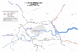
East Cross Route
Encyclopedia
Ringway 1
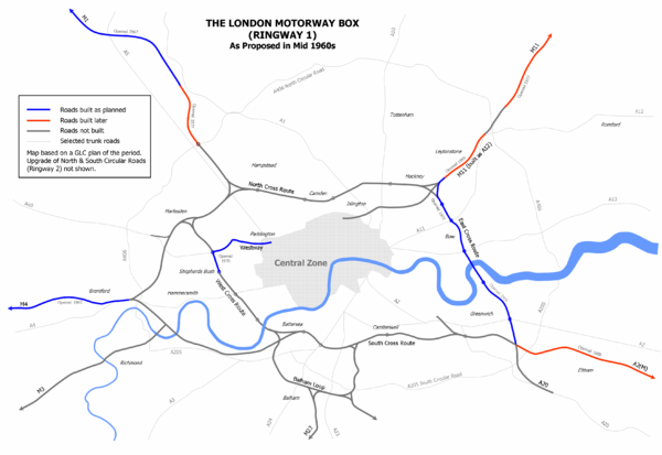
Ringway 1 or the London Motorway Box was the innermost of the series of four motorway standard roads, known as the London Ringways as part of a comprehensive scheme developed by the Greater London Council to provide high speed motorway-standard roads within the capital linking a series of radial...
as part of the London Ringways
London Ringways
The London Ringways were a series of four ring roads planned in the 1960s to circle London at various distances from the city centre. They were part of a comprehensive scheme developed by the Greater London Council to alleviate traffic congestion on the city's road system by providing high speed...
plan drawn up the 1960s to create a series of high speed roads circling and radiating out from central London
London
London is the capital city of :England and the :United Kingdom, the largest metropolitan area in the United Kingdom, and the largest urban zone in the European Union by most measures. Located on the River Thames, London has been a major settlement for two millennia, its history going back to its...
. The road was constructed in the late 1960s and early 1970s and runs from Hackney Wick
Hackney Wick
Hackney Wick is an area straddling the boundary between the London Borough of Hackney and the London Borough of Tower Hamlets in east London. It is an inner-city development situated 5 miles northeast of Charing Cross...
in north-east London, through the Blackwall Tunnel
Blackwall Tunnel
The Blackwall Tunnel is a pair of road tunnels underneath the River Thames in east London, linking the London Borough of Tower Hamlets with the London Borough of Greenwich, and part of the A102 road. The northern portal lies just south of the East India Dock Road in Blackwall; the southern...
, to Kidbrooke
Kidbrooke
Kidbrooke is a district of South East London, England, located in the London Borough of Greenwich.The district takes its name from the Kyd Brook, a watercourse which runs from Orpington to Lewisham, by which point it is part of the River Quaggy...
in south-east London. The ECR was initially designated as part of the A102
A102 road
The A102 is a road that starts in Clapton in the north London Borough of Hackney and ends in Kidbrooke in the south London Borough of Greenwich. The A102 was formerly a continuous route including two motorway sections classified as the A102 however, subsequent to the renumbering of part of the...
but has, subsequently, been partially renumbered so that sections of it are now the A2
A2 road (Great Britain)
The A2 is a major road in southern England, connecting London with the English Channel port of Dover in Kent. This route has always been of importance as a connection between the British capital of London and sea trade routes to Continental Europe...
and A12.
Route
At its northern end, the ECR (A12) follows part of the route of the former North London RailwayNorth London Railway
The North London Railway was a railway company that opened lines connecting the north of London to the East and West India Docks. The main east to west route is now part the North London Line. Other lines operated by the company fell into disuse, but were later revived as part of the Docklands...
between the closed Victoria Park and Old Ford
Old Ford railway station
Old Ford railway station was a former railway station in Old Ford, north of Bow, London. It was on the North London Railway between Victoria Park and Bow stations; the station was located on Old Ford Road, east of the junction with Lefevre Road .It opened in 1867 but was closed in 1944 after damage...
stations. The railway junction at Victoria Park, where the still open section of the North London Line
North London Line
The North London Line is a railway line which passes through the inner suburbs of north London, England. Its route is a rough semicircle from the south west to the north east, avoiding central London. The line is owned and maintained by Network Rail...
to Stratford station
Stratford station
Stratford station is a large multilevel railway station in Stratford, east London. The station is served by the National Rail services National Express East Anglia, London Overground and c2c, by London Underground's Central and Jubilee lines, and by the Docklands Light Railway . Stratford is in...
diverged, was reconstructed to permit the construction of the junction with the non-dual carriageway section of the A102 and the A106
A106 road
The A106 is an A road in London, England. It runs from Hackney to Leytonstone....
and A115 roads, above which the line passes. The branch track to the docks that ran alongside the ECR to Old Ford, which had been used only for freight since the 1940s, was subsequently closed and lifted in the early 1980s.
At Bow Road, the junction with the A11 involves a triple-layer junction. The ECR passes through in a cutting below an interchange roundabout whilst the A11 passes above on a flyover
Overpass
An overpass is a bridge, road, railway or similar structure that crosses over another road or railway...
. South of this junction, the ECR passes Bromley-by-Bow station
Bromley-by-Bow tube station
Bromley-by-Bow tube station is a London Underground station on the Blackwall Tunnel Northern Approach Road in the Bromley-by-Bow neighbourhood of the London Borough of Tower Hamlets in east London, England. The station is on the District and Hammersmith & City lines, with both services sharing a...
and skirts the River Lee Navigation
River Lee Navigation
The Lee Navigation is a canalised river incorporating the River Lea . Its course runs from Hertford Castle Weir all the way to the River Thames at Bow Creek. The first lock of the navigation is Hertford Lock the last being Bow Locks....
for a short distance as it follows the line of the former St Leonard Street. It then crosses Limehouse Cut
Limehouse Cut
The Limehouse Cut is a straight, broad canal in the East End of London, which linked the lower reaches of the River Lee Navigation to the River Thames...
and continues along what was Brunswick Road to East India Dock Road (A13). It passes under the A13 in another grade separated junction, becoming the A102, and then enters the Blackwall tunnel.
South of the River Thames
River Thames
The River Thames flows through southern England. It is the longest river entirely in England and the second longest in the United Kingdom. While it is best known because its lower reaches flow through central London, the river flows alongside several other towns and cities, including Oxford,...
, the ECR (A102) skirts Tunnel Avenue and flies over Blackwall Lane (A2203) and Woolwich Road (A206
A206 road
The A206 road links Greenwich with Greenhithe following the line of the River Thames. Today it is approximately 15 miles in length, although the final section is a relatively new road. Its primary purpose is to link into the London Orbital motorway at the Dartford Crossing and is heavily used by...
) before climbing the hill towards the Sun-in-the-Sands interchange where it passes under Shooters Hill Road (A2
A2 road (Great Britain)
The A2 is a major road in southern England, connecting London with the English Channel port of Dover in Kent. This route has always been of importance as a connection between the British capital of London and sea trade routes to Continental Europe...
/A207) and becomes the Rochester Way Relief Road (A2). It squeezes through the tight space between Rochester Way (the old A2 route) and Woolacombe Road before it ends at the Kidbrooke interchange where it connects to Kidbrooke Park Road (A2213) or continues as the later section of the Rochester Way Relief Road built in the 1980s.
History
The ECR and the other roads planned in the 1960s for central London which formed Ringway 1 of the London Ringways scheme had developed from early schemes prior to the Second World War through Sir Patrick Abercrombie'sPatrick Abercrombie
Sir Leslie Patrick Abercrombie ) was an English town planner. Educated at Uppingham School, Rutland; brother of Lascelles Abercrombie, poet and literary critic.-Career:...
County of London Plan
County of London Plan
The County of London Plan was prepared for the London County Council in 1943. Its authors were John Henry Forshaw and Sir Leslie Patrick Abercrombie ....
, 1943 and Greater London Plan, 1944 to a 1960s Greater London Council
Greater London Council
The Greater London Council was the top-tier local government administrative body for Greater London from 1965 to 1986. It replaced the earlier London County Council which had covered a much smaller area...
(GLC) scheme that would have involved the construction of many miles of motorway standard roads across the city and demolition on a massive scale. Due to the huge construction costs and widespread public opposition, most of the scheme was cancelled in 1973 and the ECR and the West Cross Route
West Cross Route
The West Cross Route is a short, dual carriageway section of the A3220 route in central London in The Royal Borough of Kensington and Chelsea, with a small part being shared with borderlining borough Hammersmith and Fulham. It runs north-south between the northern elevated roundabout junction...
and Westway
Westway (London)
The Westway is a long elevated dual carriageway section of the A40 route in west London running from Paddington to North Kensington. The road was constructed between 1964 and 1970 to relieve congestion at Shepherd's Bush caused by traffic from Western Avenue struggling to enter central London on...
in west London were the only significant parts to be built.
At the northern end of the ECR, the unrealised plans would have seen it connect at Hackney Wick to the unbuilt North Cross Route
North Cross Route
North Cross Route was a planned motorway-standard road which would have formed the northern section of Ringway 1 and would have formed the innermost circuit of the London Ringways network. The six-lane dual carriageway with grade separated junctions to an extended M1 Motorway was planned during...
which would have run west across north London and also to the M11 motorway
M11 motorway
The M11 motorway in England is a major road running approximately north from the North Circular Road in South Woodford in north-east London to the A14, north-west of Cambridge.-Route:...
which was originally planned to continue south from its current starting point at the North Circular Road
A406 road
The A406 or the North Circular Road is a road which crosses North London, UK, linking West and East London. It, together with the South Circular Road, forms a ring road through the inner part of Outer London...
(A406
A406 road
The A406 or the North Circular Road is a road which crosses North London, UK, linking West and East London. It, together with the South Circular Road, forms a ring road through the inner part of Outer London...
) in South Woodford
South Woodford
South Woodford is a suburb of north-east London in the London Borough of Redbridge, situated north-east of Charing Cross. Together with Woodford Green, Woodford Bridge and Woodford Wells it forms the area known as Woodford, the origins of which date back at least to the Saxon period...
) to join Ringway 1. Part of this plan was eventually achieved in a modified form when, in the 1990s the 'A12 Hackney to M11 link road', on 'M11 Link Road' was constructed was constructed through Leyton
Leyton
Leyton is an area of north-east London and part of the London Borough of Waltham Forest, located north east of Charing Cross. It borders Walthamstow and Leytonstone; Stratford in Newham; and Homerton and Lower Clapton in the London Borough of Hackney....
, Leytonstone
Leytonstone
Leytonstone is an area of east London and part of the London Borough of Waltham Forest. It is a high density suburban area, located seven miles north east of Charing Cross in the ceremonial county of Greater London and the historic county of Essex...
and Wanstead
Wanstead
Wanstead is a suburban area in the London Borough of Redbridge, North-East London. The main road going through Wanstead is the A12. The name is from the Anglo-Saxon words wænn and stede, meaning "settlement on a small hill"....
to connect to the ECR at Hackney Wick. This extension was designated as the A12 and required just the sort of controversial construction methods and widescale demolitions of residential areas that caused the 1960s schemes to be cancelled and provoked to the major M11 link road protest
M11 link road protest
The M11 link road protest was a major anti-road protest in east London, United Kingdom, in the early 1990s opposing the construction of the "A12 Hackney to M11 link road", also known as the M11 Link Road...
. After the new road was built, the northern part of the ECR became the A12.
Had the North Cross Route been built incoming traffic from the M11 would have been able to continue south-west through the Hackney Wick junction on a motorway standard road towards the The Angel
The Angel, Islington
Angel is a district of London, England, and part of the London Borough of Islington. The area is identified in the London Plan as one of 35 major centres in Greater London.-History:...
, Islington
Islington
Islington is a neighbourhood in Greater London, England and forms the central district of the London Borough of Islington. It is a district of Inner London, spanning from Islington High Street to Highbury Fields, encompassing the area around the busy Upper Street...
where it would have met the A1. This motorway would have followed one of two alternate routes; either along the north side of Victoria Park
Victoria Park, East London
Victoria Park is 86.18 hectares of open space that stretches out across part of the East End of London, England bordering parts of Bethnal Green, Hackney, and Bow, such as along Old Ford Road, London E3 and Victoria Park Road E9. The park is entirely within the London Borough of Tower Hamlets...
and then the alignment of the Regent's Canal
Regent's Canal
Regent's Canal is a canal across an area just north of central London, England. It provides a link from the Paddington arm of the Grand Union Canal, just north-west of Paddington Basin in the west, to the Limehouse Basin and the River Thames in east London....
or, more destructively, across the western tip of Victoria Park and along Hackney Road to the north of Bethnal Green
Bethnal Green
Bethnal Green is a district of the East End of London, England and part of the London Borough of Tower Hamlets, with the far northern parts falling within the London Borough of Hackney. Located northeast of Charing Cross, it was historically an agrarian hamlet in the ancient parish of Stepney,...
, across Hoxton
Hoxton
Hoxton is an area in the London Borough of Hackney, immediately north of the financial district of the City of London. The area of Hoxton is bordered by Regent's Canal on the north side, Wharf Road and City Road on the west, Old Street on the south, and Kingsland Road on the east.Hoxton is also a...
and then to the Angel via City Road
City Road
City Road or The City Road is a road that runs through inner north and central London. The northwestern extremity of the road is at the Angel, Islington where it forms a continuation of Pentonville Road. Pentonville Road itself is the modern name for London's first bypass, the New Road from...
.
When the North Cross Route plan was published in February 1967 this road was given the cumbersome title "Eastern Avenue Extension" but it is probable that this road would have been named "Eastway" to form a pair with the Westway which performs a similar function from Paddington
Paddington
Paddington is a district within the City of Westminster, in central London, England. Formerly a metropolitan borough, it was integrated with Westminster and Greater London in 1965...
to North Kensington
North Kensington
North Kensington is an area of west London lying north of Notting Hill Gate and south of Harrow Road.North Kensington is the key neighbourhood of Notting Hill...
and, in fact, a short section of road adjacent to the ECR north of the Hackney Wick junction does bear this name today.
At the southern end of the ECR, the plan was to connect it at Kidbrooke to the South Cross Route
South Cross Route
South Cross Route was the designation for the southern section of Ringway 1, the innermost circuit of the London Ringways network, a complex and comprehensive plan for a network of high speed roads circling and radiating out from central London designed to manage and control the flow of traffic...
(running west across south London), the A2 (heading east out of London) and the A20 (heading south-east out of London). In fact, a new dual carriageway section of the A2 was constructed through Eltham
Eltham, London
-Parks and open spaces:There is a large variety of open green space in Eltham, in the form of parkland, fields and woodland.*Avery Hill Park is large, open parkland, situated to the east of Eltham. It is most notable for its Winter Garden, a hothouse containing tropical trees and plants from around...
to meet the ECR at Kidbrooke in the 1980s providing an efficient route out of London in this direction and the A20 passes only about 0.5 mile (0.80467 km) to the south although it does not connect directly to the ECR and it was never upgraded to the motorway standard road that was intended.
Without the construction of the other parts of the 1960s motorway plans the context of the ECR has been lost in the subsequent road renumbering and the only section of the East Cross Route which continues to carry the name is the former northern motorway section of the route in Hackney Wick.
Parts of the route, at the northern end between Hackney Wick and Old Ford and south of the river between the Blackwall Tunnel and the Sun-in-the-Sands interchange, were previously classified as urban motorways and given the designation A102(M). The status was downgraded to a standard A-road
Great Britain road numbering scheme
The Great Britain road numbering scheme is a numbering scheme used to classify and identify all roads in Great Britain. Each road is given a single letter, which represents the road's category, and a subsequent number, with a length of between 1 and 4 digits. Originally introduced to arrange...
in 2000 when responsibility for trunk road
Trunk road
A trunk road, trunk highway, or strategic road is a major road—usually connecting two or more cities, ports, airports, and other things.—which is the recommended route for long-distance and freight traffic...
s in Greater London
Greater London
Greater London is the top-level administrative division of England covering London. It was created in 1965 and spans the City of London, including Middle Temple and Inner Temple, and the 32 London boroughs. This territory is coterminate with the London Government Office Region and the London...
was transferred from the Highways Agency
Highways Agency
The Highways Agency is an executive agency, part of the Department for Transport in England. It has responsibility for managing the core road network in England...
to the Greater London Authority
Greater London Authority
The Greater London Authority is the top-tier administrative body for Greater London, England. It consists of a directly elected executive Mayor of London, currently Boris Johnson, and an elected 25-member London Assembly with scrutiny powers...
.