

North Cross Route
Encyclopedia
Ringway 1
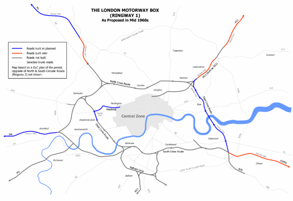
Ringway 1 or the London Motorway Box was the innermost of the series of four motorway standard roads, known as the London Ringways as part of a comprehensive scheme developed by the Greater London Council to provide high speed motorway-standard roads within the capital linking a series of radial...
(London Motorway Box) and would have formed the innermost circuit of the London Ringways
London Ringways
The London Ringways were a series of four ring roads planned in the 1960s to circle London at various distances from the city centre. They were part of a comprehensive scheme developed by the Greater London Council to alleviate traffic congestion on the city's road system by providing high speed...
network. The six-lane dual carriageway
Dual carriageway
A dual carriageway is a class of highway with two carriageways for traffic travelling in opposite directions separated by a central reservation...
with grade separated junctions to an extended M1 Motorway
M1 motorway
The M1 is a north–south motorway in England primarily connecting London to Leeds, where it joins the A1 near Aberford. While the M1 is considered to be the first inter-urban motorway to be completed in the United Kingdom, the first road to be built to motorway standard in the country was the...
was planned during the late 1960s along with the rest of the Ringway scheme. It was never constructed due to large-scale opposition from many quarters.
Route
The NCR would have started in HarlesdenHarlesden
Harlesden is an area in the London Borough of Brent, northwest London, UK. Its main focal point is the Jubilee Clock which commemorates Queen Victoria's Golden Jubilee....
with its western end having a junction to the east of Willesden Junction station
Willesden Junction station
Willesden Junction station is a Network Rail station in Harlesden, northwest London, UK. It is served by both London Overground and the Bakerloo line of the London Underground.-History:The station developed on three contiguous sites:...
with the West Cross Route
West Cross Route
The West Cross Route is a short, dual carriageway section of the A3220 route in central London in The Royal Borough of Kensington and Chelsea, with a small part being shared with borderlining borough Hammersmith and Fulham. It runs north-south between the northern elevated roundabout junction...
, the western section of Ringway 1 coming north from Shepherds Bush. Also connected to the junction here would have been Harrow Road
Harrow Road
The Harrow Road is an ancient route in Greater London which runs from Paddington in a northwesterly direction to Harrow. With minor deviations in the 19th and 20th centuries, the route remains otherwise unaltered...
(A404
A404 road
The A404 is a road in the United Kingdom that starts at Paddington in London and leads to Maidenhead in Berkshire.The road initially follows a course through London and its suburbs including Harlesden, Wembley, Harrow Pinner, and Rickmansworth...
) and an unbuilt motorway that would have headed south-west along the National Rail
National Rail
National Rail is a title used by the Association of Train Operating Companies as a generic term to define the passenger rail services operated in Great Britain...
North London Line
North London Line
The North London Line is a railway line which passes through the inner suburbs of north London, England. Its route is a rough semicircle from the south west to the north east, avoiding central London. The line is owned and maintained by Network Rail...
to meet the M4
M4 motorway
The M4 motorway links London with South Wales. It is part of the unsigned European route E30. Other major places directly accessible from M4 junctions are Reading, Swindon, Bristol, Newport, Cardiff and Swansea...
at Gunnersbury
Gunnersbury
Gunnersbury is a place in the London Borough of Hounslow, with its northern edge in the London Borough of Ealing, west London. It has an area of less than half a square kilometre and is within the west area of the Chiswick W4 postal district of London....
. A spur from this motorway would have connected to the Western Avenue (A40) near Gypsy Corner.
Heading east, the NCR would have run in a cutting along the north side of the North London Line to Brondesbury
Brondesbury
Brondesbury is an area of Kilburn in London, England. It is shared between the boroughs of Brent and Camden.-Nearest places:* Kilburn* Willesden* Kensal Green* Cricklewood-Nearest tube stations:* Kilburn * West Hampstead...
and Kilburn High Road (A5) . To accommodate the motorway cutting, most of the houses on the south side of the roads lining the railway would have been demolished. Roads that crossed the railway line, such as Willesden Lane, would have also bridged the sunken motorway.
Between Kilburn High Road and West End Lane a major Y-shaped junction would have been constructed where the NCR was to meet the intended end of the M1 motorway
M1 motorway
The M1 is a north–south motorway in England primarily connecting London to Leeds, where it joins the A1 near Aberford. While the M1 is considered to be the first inter-urban motorway to be completed in the United Kingdom, the first road to be built to motorway standard in the country was the...
. This was originally planned to be continued south of its Staples Corner
Staples Corner
Staples Corner is a major road junction in London, United Kingdom.It has two linked roundabouts and flyovers, which connect the A406 North Circular Road with the A5 Edgware Road and the start of the M1 motorway...
junction with the North Circular Road (A406)
A406 road
The A406 or the North Circular Road is a road which crosses North London, UK, linking West and East London. It, together with the South Circular Road, forms a ring road through the inner part of Outer London...
(Ringway 2
Ringway 2
Ringway 2 was the second innermost of the series of four London Ringways, ring roads planned in the 1960s to circle London at various distances from the city centre...
) along the east side of the St. Pancras mainline through Cricklewood
Cricklewood
Cricklewood is a district of North London, England whose northeastern part is in the London Borough of Barnet, western part is the London Borough of Brent and southeastern part is in London Borough of Camden.-History:...
. The M1 junction would have been provided with slip roads allowing traffic movements between the M1 and NCR in each direction and the NCR would also have been provided with additional lanes between this junction and a roundabout to have been built at Finchley Road
Finchley Road
Finchley Road, an inner city main road which runs for about 7 kilometres/4 miles, is one of the major thoroughfares of north London, England.Originally named Finchley New Road, it was built as a turnpike road in the late 1820s/early 1830s to provide a by-pass to the existing route north from London...
(A41
A41 road
The A41 is a formerly-major trunk road in England that links London and Birkenhead, although it has now largely been superseded by motorways. It passes through or near various towns and cities including Watford, Hemel Hempstead, Aylesbury, Solihull, Birmingham, West Bromwich, Wolverhampton,...
) between Finchley Road
Finchley Road tube station
Finchley Road tube station is a London Underground station at the corner of Finchley Road and Canfield Gardens in the London Borough of Camden, North London. It is on the Jubilee Line, between West Hampstead and Swiss Cottage and on the Metropolitan Line between Baker Street and Wembley Park. It is...
Underground
London Underground
The London Underground is a rapid transit system serving a large part of Greater London and some parts of Buckinghamshire, Hertfordshire and Essex in England...
station and Finchley Road & Frognal
Finchley Road & Frognal railway station
Finchley Road & Frognal railway station is on Finchley Road in the London Borough of Camden in North London. It is on the North London Line, and the station and all trains serving it are operated by London Overground. It is in Travelcard Zone 2...
National Rail station.
East of Finchley Road there were three alternative routes towards Camden Town
Camden Town
-Economy:In recent years, entertainment-related businesses and a Holiday Inn have moved into the area. A number of retail and food chain outlets have replaced independent shops driven out by high rents and redevelopment. Restaurants have thrived, with the variety of culinary traditions found in...
:
- The NCR would have entered a cut-and-cover tunnel heading south-west through the western part of Belsize ParkBelsize ParkBelsize Park is an area of north-west London, England, in the London Borough of Camden.It is located north-west of Charing Cross and situated on the Northern Line. It borders Hampstead to the north and west, Kentish Town and Gospel Oak to the east, Camden Town to the south east and Primrose Hill...
before returning into open air south of Eton Avenue and then crossing over Adelaide Road to follow the EustonEuston railway stationEuston railway station, also known as London Euston, is a central London railway terminus in the London Borough of Camden. It is the sixth busiest rail terminal in London . It is one of 18 railway stations managed by Network Rail, and is the southern terminus of the West Coast Main Line...
mainline the short distance to Chalk FarmChalk FarmChalk Farm is an area of north London, England. It lies directly to the north of Camden Town and its underground station is the closest tube station to the nearby, upmarket neighbourhood of Primrose Hill....
then crossing above a British Rail goods yard there and heading east along the railway to central Camden Town to rejoin the North London Line. - The NCR would have continued to follow the North London Line through Gospel OakGospel OakGospel Oak is an inner urban area of north London in the London Borough of Camden below Hampstead Heath. It is bordered by the more affluent areas of Belsize Park to the west, Kentish Town to the south, Eastern Hampstead to the North and Dartmouth Park and Tufnell Park to the east...
and then south through Kentish TownKentish TownKentish Town is an area of north west London, England in the London Borough of Camden.-History:The most widely accepted explanation of the name of Kentish Town is that it derived from 'Ken-ditch' meaning the 'bed of a waterway'...
to Camden Town. - The NCR would have continued to follow the North London Line to Gospel Oak but switched there to follow the St. Pancras mainline to avoid central Camden Town and rejoin the North London Line near York Way.
Despite the destruction involved in constructing the tunnel through Belsize Park, the preferred route appears to have been alternative 1 as this provided the best means of creating an interchange with the planned Camden Town by-pass
Bypass (road)
A bypass is a road or highway that avoids or "bypasses" a built-up area, town, or village, to let through traffic flow without interference from local traffic, to reduce congestion in the built-up area, and to improve road safety....
which would have connected Albany Street (south-west of Camden Town) to Camden Road (north-east of Camden Town).
East of Camden Town, the NCR would have continued to follow the north side of the North London Line to Caledonian Road (A5203), where another junction would have been provided, then through Highbury
Highbury
- Early Highbury :The area now known as Islington was part of the larger manor of Tolentone, which is mentioned in the Domesday Book. Tolentone was owned by Ranulf brother of Ilger and included all the areas north and east of Canonbury and Holloway Road. The manor house was situated by what is now...
and Canonbury
Canonbury
Canonbury is a residential district in the London Borough of Islington in the north of London. It is roughly in the area between Essex Road, Upper Street and Cross Street and either side of St Paul's Road....
to Dalston
Dalston
Dalston is a district of north-east London, England, located in the London Borough of Hackney. It is situated northeast of Charing Cross. The area is identified in the London Plan as one of 35 major centres in Greater London...
where the NCR would have passed over Kingsland High Street (A10) and along Ridley Road Market before a further junction would have been built to connect to the High Street and Dalston Lane. The final section of the NCR would have crossed through Hackney
Hackney Central
Hackney Central is the central district of the London Borough of Hackney in London, England. It comprises the area roughly surrounding, and extending north from Mare Street. It is situated north east of Charing Cross...
town centre parallel with the railway viaduct, passing south of 16th century Sutton House, East London's oldest house, and on through Homerton
Homerton
Homerton is a place in the London Borough of Hackney. It is bordered to the west by Hackney Central, to the north by Lower Clapton, in the east by Hackney Wick, Leyton and by South Hackney to the south.-Origins:...
and Hackney Wick
Hackney Wick
Hackney Wick is an area straddling the boundary between the London Borough of Hackney and the London Borough of Tower Hamlets in east London. It is an inner-city development situated 5 miles northeast of Charing Cross...
where it would have interchanged with the East Cross Route
East Cross Route
East Cross Route is a dual-carriageway road constructed in east London as part of the uncompleted Ringway 1 as part of the London Ringways plan drawn up the 1960s to create a series of high speed roads circling and radiating out from central London...
coming north from Bow
Bow, London
Bow is an area of London, England, United Kingdom in the London Borough of Tower Hamlets. It is a built-up, mostly residential district located east of Charing Cross, and is a part of the East End.-Bridges at Bowe:...
, the proposed M11 motorway
M11 motorway
The M11 motorway in England is a major road running approximately north from the North Circular Road in South Woodford in north-east London to the A14, north-west of Cambridge.-Route:...
coming south-west from Leyton
Leyton
Leyton is an area of north-east London and part of the London Borough of Waltham Forest, located north east of Charing Cross. It borders Walthamstow and Leytonstone; Stratford in Newham; and Homerton and Lower Clapton in the London Borough of Hackney....
and a motorway heading south-west towards The Angel, Islington
The Angel, Islington
Angel is a district of London, England, and part of the London Borough of Islington. The area is identified in the London Plan as one of 35 major centres in Greater London.-History:...
. To facilitate this complex junction the North London Line was diverted to a new route through Hackney Wick.
History
The NCR and the other roads planned in the 1960s for central London had developed from early schemes prior to the Second World War through Sir Patrick Abercrombie'sPatrick Abercrombie
Sir Leslie Patrick Abercrombie ) was an English town planner. Educated at Uppingham School, Rutland; brother of Lascelles Abercrombie, poet and literary critic.-Career:...
County of London Plan
County of London Plan
The County of London Plan was prepared for the London County Council in 1943. Its authors were John Henry Forshaw and Sir Leslie Patrick Abercrombie ....
, 1943 and Greater London Plan, 1944 to a 1960s Greater London Council
Greater London Council
The Greater London Council was the top-tier local government administrative body for Greater London from 1965 to 1986. It replaced the earlier London County Council which had covered a much smaller area...
(GLC) scheme that would have involved the construction of many miles of motorway standard roads across the city and demolition on a massive scale. Due to the huge construction costs and widespread public opposition, the GLC had dropped the NCR from the Ringway Plans by 1972 and most of the rest of the scheme was cancelled in 1973. Only the East Cross Route, part of the West Cross Route and the Westway
Westway (London)
The Westway is a long elevated dual carriageway section of the A40 route in west London running from Paddington to North Kensington. The road was constructed between 1964 and 1970 to relieve congestion at Shepherd's Bush caused by traffic from Western Avenue struggling to enter central London on...
were built.