
2007 South Asian floods
Encyclopedia
The 2007 South Asian floods were a series of floods in India
, Nepal
, Bhutan
, Pakistan
and Bangladesh
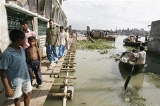
. News Agencies, citing the Indian and Bangladeshi governments, place the death toll in excess of 2,000. By 3 August approximately 20 million had been displaced and by 10 August some 30 million people in India, Bangladesh and Nepal had been affected by flooding.
UNICEF said that the situation "is being described as the worst flooding in living memory".
 B. P. Yadav of the Indian Meteorological Department reported that "we've been getting constant rainfall in these areas for nearly 20 days" due to abnormal monsoon
patterns. Flooding in Pakistan
began during the landfall of Cyclone 03B in June 2007. Pakistani states Balochistan
and Sindh
were particularly affected.
Melting snow from the Himalayan glacier
s increased the water levels of the Brahmaputra River
.
 On August 1, there was flooding on the Padma
and Brahmaputra rivers. By August 3, the main highway
connecting Dhaka
to the rest of the country was impassable, many districts were flood-affected and 500,000 people had been marooned. By August 7 an estimated 7.5 million people had fled their homes. By August 8 more than 50,000 people had diarrhoea or other waterborne diseases and more than 400,000 people were in temporary shelters. By August 11, flood deaths were still occurring in Bangladesh, the number of people with flood-related diseases was increasing and about 100,000 people had caught dysentery or diarrhoea. By August 13, the confirmed death toll in Bangladesh was 405.
By 15 August, five million people were still displaced, the estimated death toll was nearly 500, and all six of Bangladesh's divisions
were affected.
barisal
is not true that in barisal were big floods in 2007
 In Bhutan, the rain had led to landslides across the country, disrupting a number of major roads.
 By August 7 in India, an estimated 13.7 million people had fled their homes.
According to the Indian government, the total cost of the monsoon
this year, of which these floods are a part, is in excess of Rs. 130 crore
s (32 million USD) since June 1 The full extent of the damage and number of lives lost may never be known. President
Pratibha Patil
has condoled the loss of lives due to the floods.
that were affected by flooding on July 12 include Lakhimpur, Chamuah Gaon, Nowboicha and Bharaluwa Gaon.
, approximately 100,000 sought shelter in 500 government-sponsored relief camps. Millions of dollars' worth of crop
s were also destroyed. 500,000 residents in Assam were displaced, and nineteen have been killed. On August 1, 2007, a teenage boy from Assam was shot by a police officer
after a flood as survivors attacked a group of aid workers.
and Uttar Pradesh
were the hardest hit states
due to their high population density. By August 3, the estimated death toll was 41 people, and 48 schoolgirls were marooned in a school in the Darbhanga
district. By August 8, an estimated 10 million people in Bihar had been affected by flooding. Army helicopters delivered food packets to Bihar residents and 180 relief camps were set up. By August 10, aid workers in Bihar said the number of people with diarrhoea had jumped dramatically and by August 11, flood deaths were still occurring.
reported 269 millimetres (10 inches) of rain and fresh flooding was reported in Gujarat. By the next day, nine people had been killed and more than 400 villages were cut off. By August 10, more than 22,000 people were displaced and health workers were disinfecting the worst-hit areas.
, a cloudburst caused a landslide that buried an entire village, killing an estimated 60 people.
, the part of Kashmir
administered by India, that were affected by flooding on August 12 include Jammu city, Udhampur, Nikki Tawi, and lower Satwari.
and Kangsabati rivers overflowed their banks in late June, but levels finally began to fall as of August 6. The Durgapur Barrage
and Kangsabati Dam
(near Bankura
) may be partly responsible. In North Bengal, the floods have caused economic damage also estimated in the millions of U.S. dollars (at least Rs. 50 crores); and in Siliguri
, flash floods have wiped away at least 100 houses on a single night (July 28,2007). The state government of West Bengal has set up facilities to house 50,000 refugees. As the flood has affected parts of the East Midnapore
(Purba Medinipur
) district, long-standing political divisions and conflicts
have flared in the wake of the floods.
and parts of Maharashtra were waterlogged. On August 7 there was extensive flooding in the Gadchiroli district.
that were affected by flooding on July 12 include the West Garo Hills district, the Tura and Rishipara areas.
that were affected by flooding on July 12 include Udaipur, Amarpur and Sonamura.
, which was known as Uttaranchal until 2006, was affected by flooding on August 12.
 In Nepal
, eighty-four people were killed by the floods and resulting landslide
s and 9,700 families were displaced. Twenty-eight of the country's seventy-five districts
were affected, in eleven of Nepal's fourteen zones
and all five of Nepal's regions
. Nepali officials were concerned about the spread of waterborne diseases
. By August 7 an estimated 333,500 people in Nepal were affected by flooding.
that were affected by flooding from July 23 include Dhanusha, Mahottari, Sindhuli, Sarlahi and Ramechhap.
that were affected by flooding from July 23 include Chitwan and Rautahat.
that were affected by flooding from July 23 include Udayapur, Okhaldhunga, Saptari, Solukhumbu and Siraha.
that were affected by flooding from July 23 include Baitadi and Darchula.
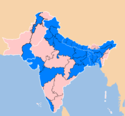
India
India , officially the Republic of India , is a country in South Asia. It is the seventh-largest country by geographical area, the second-most populous country with over 1.2 billion people, and the most populous democracy in the world...
, Nepal
Nepal
Nepal , officially the Federal Democratic Republic of Nepal, is a landlocked sovereign state located in South Asia. It is located in the Himalayas and bordered to the north by the People's Republic of China, and to the south, east, and west by the Republic of India...
, Bhutan
Bhutan
Bhutan , officially the Kingdom of Bhutan, is a landlocked state in South Asia, located at the eastern end of the Himalayas and bordered to the south, east and west by the Republic of India and to the north by the People's Republic of China...
, Pakistan
Pakistan
Pakistan , officially the Islamic Republic of Pakistan is a sovereign state in South Asia. It has a coastline along the Arabian Sea and the Gulf of Oman in the south and is bordered by Afghanistan and Iran in the west, India in the east and China in the far northeast. In the north, Tajikistan...
and Bangladesh
Bangladesh
Bangladesh , officially the People's Republic of Bangladesh is a sovereign state located in South Asia. It is bordered by India on all sides except for a small border with Burma to the far southeast and by the Bay of Bengal to the south...
. News Agencies, citing the Indian and Bangladeshi governments, place the death toll in excess of 2,000. By 3 August approximately 20 million had been displaced and by 10 August some 30 million people in India, Bangladesh and Nepal had been affected by flooding.
UNICEF said that the situation "is being described as the worst flooding in living memory".
Background
Monsoon
Monsoon is traditionally defined as a seasonal reversing wind accompanied by corresponding changes in precipitation, but is now used to describe seasonal changes in atmospheric circulation and precipitation associated with the asymmetric heating of land and sea...
patterns. Flooding in Pakistan
Pakistan
Pakistan , officially the Islamic Republic of Pakistan is a sovereign state in South Asia. It has a coastline along the Arabian Sea and the Gulf of Oman in the south and is bordered by Afghanistan and Iran in the west, India in the east and China in the far northeast. In the north, Tajikistan...
began during the landfall of Cyclone 03B in June 2007. Pakistani states Balochistan
Balochistan (Pakistan)
Balochistan is one of the four provinces or federating units of Pakistan. With an area of 134,051 mi2 or , it is the largest province of Pakistan, constituting approximately 44% of the total land mass of Pakistan. According to the 1998 population census, Balochistan had a population of...
and Sindh
Sindh
Sindh historically referred to as Ba'ab-ul-Islam , is one of the four provinces of Pakistan and historically is home to the Sindhi people. It is also locally known as the "Mehran". Though Muslims form the largest religious group in Sindh, a good number of Christians, Zoroastrians and Hindus can...
were particularly affected.
Melting snow from the Himalayan glacier
Glacier
A glacier is a large persistent body of ice that forms where the accumulation of snow exceeds its ablation over many years, often centuries. At least 0.1 km² in area and 50 m thick, but often much larger, a glacier slowly deforms and flows due to stresses induced by its weight...
s increased the water levels of the Brahmaputra River
Brahmaputra River
The Brahmaputra , also called Tsangpo-Brahmaputra, is a trans-boundary river and one of the major rivers of Asia. It is the only Indian river that is attributed the masculine gender and thus referred to as a in Indo-Aryan languages and languages with Indo-Aryan influence...
.
Areas affected in Bangladesh
Padma River
The Padma is a major trans-boundary river in Bangladesh. It is the main distributary of the Ganges , which originates in the Himalayas. The Padma enters Bangladesh from India near Chapai Nababganj...
and Brahmaputra rivers. By August 3, the main highway
Highway
A highway is any public road. In American English, the term is common and almost always designates major roads. In British English, the term designates any road open to the public. Any interconnected set of highways can be variously referred to as a "highway system", a "highway network", or a...
connecting Dhaka
Dhaka
Dhaka is the capital of Bangladesh and the principal city of Dhaka Division. Dhaka is a megacity and one of the major cities of South Asia. Located on the banks of the Buriganga River, Dhaka, along with its metropolitan area, had a population of over 15 million in 2010, making it the largest city...
to the rest of the country was impassable, many districts were flood-affected and 500,000 people had been marooned. By August 7 an estimated 7.5 million people had fled their homes. By August 8 more than 50,000 people had diarrhoea or other waterborne diseases and more than 400,000 people were in temporary shelters. By August 11, flood deaths were still occurring in Bangladesh, the number of people with flood-related diseases was increasing and about 100,000 people had caught dysentery or diarrhoea. By August 13, the confirmed death toll in Bangladesh was 405.
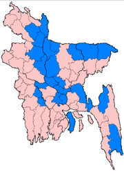
By 15 August, five million people were still displaced, the estimated death toll was nearly 500, and all six of Bangladesh's divisions
Divisions of Bangladesh
||Bangladesh is divided into seven major administrative regions called divisions . Each division is named after the major city within its jurisdiction that serves as the administrative capital of that division:...
were affected.
barisal
is not true that in barisal were big floods in 2007
Dhaka
Districts in Dhaka that were affected by flooding on 21 July include Dhaka, Munshiganj, Rajbari, Madaripur, Shariatpur, Manikganj, Netrakona, Jamalpur and Tangail.Khulna
Districts in Khulna that were affected by flooding on 21 July include Narail and Magura.Rajshahi
Places in Rajshahi that were affected by flooding on 21 July include Sirajganj, Rangpur, Gaibandha, Bogra and Kurigram.Sylhet
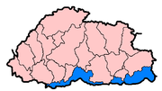
Districts in Sylhet that were affected by flooding on July 21 include Sylhet, Sunamganj and Sherpur.Areas affected in Bhutan
Samdrup Jongkhar and Sarpang
By 5 August water was still above the warning level in the foothills of Bhutan.Areas affected in India
According to the Indian government, the total cost of the monsoon
Monsoon
Monsoon is traditionally defined as a seasonal reversing wind accompanied by corresponding changes in precipitation, but is now used to describe seasonal changes in atmospheric circulation and precipitation associated with the asymmetric heating of land and sea...
this year, of which these floods are a part, is in excess of Rs. 130 crore
Crore
A crore is a unit in the Indian number system equal to ten million , or 100 lakhs. It is widely used in India, Bangladesh, Nepal, and Pakistan....
s (32 million USD) since June 1 The full extent of the damage and number of lives lost may never be known. President
President of India
The President of India is the head of state and first citizen of India, as well as the Supreme Commander of the Indian Armed Forces. President of India is also the formal head of all the three branches of Indian Democracy - Legislature, Executive and Judiciary...
Pratibha Patil
Pratibha Patil
Pratibha Devisingh Patil is the 12th President of the Republic of India and first woman to hold the office. She was sworn in as President of India on 25 July 2007, succeeding Dr. A.P.J...
has condoled the loss of lives due to the floods.
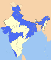
Arunachal Pradesh
Places in Arunachal PradeshArunachal Pradesh
Arunachal Pradesh is a state of India, located in the far northeast. It borders the states of Assam and Nagaland to the south, and shares international borders with Burma in the east, Bhutan in the west, and the People's Republic of China in the north. The majority of the territory is claimed by...
that were affected by flooding on July 12 include Lakhimpur, Chamuah Gaon, Nowboicha and Bharaluwa Gaon.
Assam
In AssamAssam
Assam , also, rarely, Assam Valley and formerly the Assam Province , is a northeastern state of India and is one of the most culturally and geographically distinct regions of the country...
, approximately 100,000 sought shelter in 500 government-sponsored relief camps. Millions of dollars' worth of crop
Crop
Crop may refer to:* Crop, a plant grown and harvested for agricultural use* Crop , part of the alimentary tract of some animals* Crop , a modified whip used in horseback riding or disciplining humans...
s were also destroyed. 500,000 residents in Assam were displaced, and nineteen have been killed. On August 1, 2007, a teenage boy from Assam was shot by a police officer
Police officer
A police officer is a warranted employee of a police force...
after a flood as survivors attacked a group of aid workers.
Bihar and Uttar Pradesh
BiharBihar
Bihar is a state in eastern India. It is the 12th largest state in terms of geographical size at and 3rd largest by population. Almost 58% of Biharis are below the age of 25, which is the highest proportion in India....
and Uttar Pradesh
Uttar Pradesh
Uttar Pradesh abbreviation U.P. , is a state located in the northern part of India. With a population of over 200 million people, it is India's most populous state, as well as the world's most populous sub-national entity...
were the hardest hit states
States and territories of India
India is a federal union of states comprising twenty-eight states and seven union territories. The states and territories are further subdivided into districts and so on.-List of states and territories:...
due to their high population density. By August 3, the estimated death toll was 41 people, and 48 schoolgirls were marooned in a school in the Darbhanga
Darbhanga
Darbhangā is a twin city and a municipal corporation and the capital city of the Darbhanga district and Darbhanga Division in the state of Bihar, India. It is one of the most important districts of North Bihar situated in the very heart of Mithilanchal. According to the latest 2011 census, the...
district. By August 8, an estimated 10 million people in Bihar had been affected by flooding. Army helicopters delivered food packets to Bihar residents and 180 relief camps were set up. By August 10, aid workers in Bihar said the number of people with diarrhoea had jumped dramatically and by August 11, flood deaths were still occurring.
Gujarat
On August 8, JamnagarJamnagar
Jamnagar is a city and a municipal corporation in Jamnagar district in the Indian state of Gujarat. The city was built up substantially by Maharaja Kumar Shri Ranjitsinhji in the 1920s, when the district was known as Nawanagar. The district lies just to the south of the Gulf of Kutch and is...
reported 269 millimetres (10 inches) of rain and fresh flooding was reported in Gujarat. By the next day, nine people had been killed and more than 400 villages were cut off. By August 10, more than 22,000 people were displaced and health workers were disinfecting the worst-hit areas.
Himachal Pradesh
On August 14 in Himachal PradeshHimachal Pradesh
Himachal Pradesh is a state in Northern India. It is spread over , and is bordered by the Indian states of Jammu and Kashmir on the north, Punjab on the west and south-west, Haryana and Uttar Pradesh on the south, Uttarakhand on the south-east and by the Tibet Autonomous Region on the east...
, a cloudburst caused a landslide that buried an entire village, killing an estimated 60 people.
Jammu and Kashmir
Parts of Jammu and KashmirJammu and Kashmir
Jammu and Kashmir is the northernmost state of India. It is situated mostly in the Himalayan mountains. Jammu and Kashmir shares a border with the states of Himachal Pradesh and Punjab to the south and internationally with the People's Republic of China to the north and east and the...
, the part of Kashmir
Kashmir
Kashmir is the northwestern region of the Indian subcontinent. Until the mid-19th century, the term Kashmir geographically denoted only the valley between the Great Himalayas and the Pir Panjal mountain range...
administered by India, that were affected by flooding on August 12 include Jammu city, Udhampur, Nikki Tawi, and lower Satwari.
Jharkhand and West Bengal
While relief efforts have been concentrated elsewhere in India, the plight of the traditional region of Bengal (the flood plains of the Ganges-Brahmaputra-Meghna river delta and its tributaries) has been less reported. The DamodarDamodar
Damodar can refer to:* Damodar Das Arora a famous Punjabi Poet* Damodar River in India* Damodar * Damodar * Damodar Pande - First Prime Minister of Nepal...
and Kangsabati rivers overflowed their banks in late June, but levels finally began to fall as of August 6. The Durgapur Barrage
Durgapur Barrage
Durgapur Barrage is across the Damodar River at Durgapur in Bardhaman district in the Indian state of West Bengal.-Overview:The Damodar River Valley Project on the Damodar River and its principal tributary, the...
and Kangsabati Dam
Dam
A dam is a barrier that impounds water or underground streams. Dams generally serve the primary purpose of retaining water, while other structures such as floodgates or levees are used to manage or prevent water flow into specific land regions. Hydropower and pumped-storage hydroelectricity are...
(near Bankura
Bankura
Bankura is a city and a municipality in Bankura District in the state of West Bengal, India. It is the headquarters of the Bankura District.-Etymology:...
) may be partly responsible. In North Bengal, the floods have caused economic damage also estimated in the millions of U.S. dollars (at least Rs. 50 crores); and in Siliguri
Siliguri
Siliguri is a city in the Indian state of West Bengal. It is located in the Siliguri Corridor or Chicken's Neck - a very narrow strip of land linking mainland India to its north-eastern states. It is also the transit point for air, road and rail traffic to the neighbouring countries of Nepal,...
, flash floods have wiped away at least 100 houses on a single night (July 28,2007). The state government of West Bengal has set up facilities to house 50,000 refugees. As the flood has affected parts of the East Midnapore
Midnapore
Midnapore is the district headquarters of Paschim Medinipur district of West Bengal. It is situated on the banks of the Kangsabati River . This area had taken a pioneering role in India's freedom struggle...
(Purba Medinipur
Purba Medinipur
Purba Medinipur district , or East Midnapore district is an administrative unit in the Indian state of West Bengal. It is the southernmost district of Burdwan division – one of the three administrative divisions of West Bengal. The headquarter is located at Tamluk...
) district, long-standing political divisions and conflicts
Partition of Midnapore
The Partition of Midnapore was the administrative breakup of the Midnapore District of West Bengal, India into the western Paschim Medinipur and the eastern Purba Medinipur districts that became effective on January 1, 2002...
have flared in the wake of the floods.
Maharashtra
By August 3 most streets were flooded in MumbaiMumbai
Mumbai , formerly known as Bombay in English, is the capital of the Indian state of Maharashtra. It is the most populous city in India, and the fourth most populous city in the world, with a total metropolitan area population of approximately 20.5 million...
and parts of Maharashtra were waterlogged. On August 7 there was extensive flooding in the Gadchiroli district.
Meghalaya
Places in MeghalayaMeghalaya
Meghalaya is a state in north-eastern India. The word "Meghalaya" literally means the Abode of Clouds in Sanskrit and other Indic languages. Meghalaya is a hilly strip in the eastern part of the country about 300 km long and 100 km wide, with a total area of about 8,700 sq mi . The...
that were affected by flooding on July 12 include the West Garo Hills district, the Tura and Rishipara areas.
Tripura
Places in TripuraTripura
Tripura is a state in North-East India, with an area of . It is the third smallest state of India, according to area. Tripura is surrounded by Bangladesh on the north, south, and west. The Indian states of Assam and Mizoram lie to the east. The capital is Agartala and the main languages spoken are...
that were affected by flooding on July 12 include Udaipur, Amarpur and Sonamura.
Uttarakhand
UttarakhandUttarakhand
Uttarakhand , formerly Uttaranchal, is a state in the northern part of India. It is often referred to as the Land of Gods due to the many holy Hindu temples and cities found throughout the state, some of which are among Hinduism's most spiritual and auspicious places of pilgrimage and worship...
, which was known as Uttaranchal until 2006, was affected by flooding on August 12.
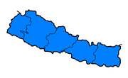
Areas affected in Nepal
Nepal
Nepal , officially the Federal Democratic Republic of Nepal, is a landlocked sovereign state located in South Asia. It is located in the Himalayas and bordered to the north by the People's Republic of China, and to the south, east, and west by the Republic of India...
, eighty-four people were killed by the floods and resulting landslide
Landslide
A landslide or landslip is a geological phenomenon which includes a wide range of ground movement, such as rockfalls, deep failure of slopes and shallow debris flows, which can occur in offshore, coastal and onshore environments...
s and 9,700 families were displaced. Twenty-eight of the country's seventy-five districts
Districts of Nepal
Nepal's 14 administrative zones are subdivided into 75 districts . These districts are listed below, by zone...
were affected, in eleven of Nepal's fourteen zones
Zones of Nepal
Nepal is divided into 14 administrative zones , and 75 districts . The 14 administrative zones are grouped into five development regions...
and all five of Nepal's regions
Regions of Nepal
Nepal is divided into 14 administrative zones , which are divided into 75 districts . The 14 administrative zones are grouped into five development regions...
. Nepali officials were concerned about the spread of waterborne diseases
Waterborne diseases
Waterborne diseases are caused by pathogenic microorganisms which are directly transmitted when contaminated fresh water is consumed. Contaminated fresh water, used in the preparation of food, can be the source of foodborne disease through consumption of the same microorganisms...
. By August 7 an estimated 333,500 people in Nepal were affected by flooding.
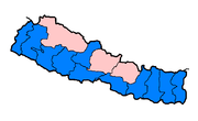
Janakpur Zone
Districts in the Janakpur ZoneJanakpur Zone
Janakpur Zone The headquarters of Janakpur zone and its main city is Janakpur. Close to the Indian border, it is a historic city of Hinduism. The city was believed to be the capital city of the King Janak, the father in law of Lord Rama, the son of the then King of Ayodhya, Dasharatha. The city...
that were affected by flooding from July 23 include Dhanusha, Mahottari, Sindhuli, Sarlahi and Ramechhap.
Narayani Zone
Districts in the Narayani ZoneNarayani Zone
- Geography :Narayani contains parts of the Terai, Inner Terai, and Hill regions of Nepal, but it does not contain any of the Mountain or Himalayan region. Narayani is rich in flora and fauna...
that were affected by flooding from July 23 include Chitwan and Rautahat.
Koshi Zone
Districts in the Koshi Zone that were affected by flooding from July 23 include Sunsari and Morang.Sagarmatha Zone
Districts in the Sagarmatha ZoneSagarmatha Zone
Sagarmāthā zone in the north, hill districts in the center, and valley districts of the Terai in the south. The borders of this zone are China to the north, India to the south, the Koshi Zone to the east and the Janakpur Zone to the west....
that were affected by flooding from July 23 include Udayapur, Okhaldhunga, Saptari, Solukhumbu and Siraha.
Mahakali Zone
Districts in the Mahakali ZoneMahakali Zone
Mahakali|Kali River]] or Mahakali River, which originates from Kalapani.Mahakali's headquarter is Mahendranagar in Kanchanpur District. The zone covers the Himalayan range including Api Peak in the North, Hill valleys, Inner Terai valleys such as Patan in Baitadi District in the center and the...
that were affected by flooding from July 23 include Baitadi and Darchula.
Seti Zone
Districts in the Seti ZoneSeti Zone
Seti ZoneSeti ZoneSeti ZoneSeti ZoneSeti ZoneSeti ZoneSeti ZoneSeti ZoneSeti Zone' onMouseout='HidePop("26562")' href="/topics/Bheri_Zone">Bheri Zone
that were affected by flooding from July 23 include Banke, Bardiya and Surkhet.
was affected by flooding from July 23.
that were affected by flooding from July 23 include Nawalparasi and Gulmi.
. By August 12, flood waters were sweeping through villages in southern Pakistan.
Malteser International,
Deutsche Welthungerhilfe,
Direct Relief International,
World Concern,
Islamic Relief,
Church World Service,
International Save the Children Alliance,
Lutheran World Relief,
Medical Teams International,
Care International,
Catholic Relief Services,
British Red Cross Society,
World Vision,
Diakonie Emergency Aid,
David McAntony Gibson Foundation,
Caritas Internationalis,
Action by Churches Together (ACT),
Adventist Development and Relief Agency (ADRA),
Baptist World Aid (BWAid),
Mercy Corps,
and many others.
Bheri Zone
Bheri Anchal in the Mid-Western Development Region of Nepal. Nepalgunj is the administrative headquarters.Cities and towns are Narayan, Jajarkot and Chhinchu in the "hills"; Nepalgunj, Gularia and Kohalpur in Terai; Birendranagar in Surkhet Valley in the Inner Terai.Bheri Zone is divided into five...
that were affected by flooding from July 23 include Banke, Bardiya and Surkhet.
Dhawalagiri Zone
The Baglung District in the Dhawalagiri ZoneDhawalagiri Zone
Dhawalagiri is one of the fourteen zones of Nepal. It comes under the Western division of Nepal. Baglung is the headquarters of this zone. Famous trekking areas like Mustang, Muktinath, Kali Gandaki valley and Mt Dhaulagiri fall in this zone...
was affected by flooding from July 23.
Lumbini Zone
Districts in the Lumbini ZoneLumbini Zone
Lumbini Zone, is one of the 14 zones of Nepal and is home to Lumbini site, the birthplace of Siddhartha Gautama, who later became the historical Buddha and founder of the Buddhist philosophy...
that were affected by flooding from July 23 include Nawalparasi and Gulmi.
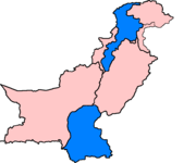
Areas affected in Pakistan
Sindh
By August 11, 28 people had died in rain-related accidents in SindhSindh
Sindh historically referred to as Ba'ab-ul-Islam , is one of the four provinces of Pakistan and historically is home to the Sindhi people. It is also locally known as the "Mehran". Though Muslims form the largest religious group in Sindh, a good number of Christians, Zoroastrians and Hindus can...
. By August 12, flood waters were sweeping through villages in southern Pakistan.
Khyber-Pakhtunkhwa
The Kohistan district of Khyber Pakhtunkhwa was affected by flooding on August 12.International response
By August 15, non-governmental organisations, many with contributions from governments, that were contributing aid includedMalteser International,
Deutsche Welthungerhilfe,
Direct Relief International,
World Concern,
Islamic Relief,
Church World Service,
International Save the Children Alliance,
Lutheran World Relief,
Medical Teams International,
Care International,
Catholic Relief Services,
British Red Cross Society,
World Vision,
Diakonie Emergency Aid,
David McAntony Gibson Foundation,
Caritas Internationalis,
Action by Churches Together (ACT),
Adventist Development and Relief Agency (ADRA),
Baptist World Aid (BWAid),
Mercy Corps,
and many others.
External links
- Dartmouth Flood Observatory 2007 Global Register of Major Flood Events
- UN OCHA Report: Severe Flooding in Asia: as of 15 August 2007. Includes flood map.
- South Asia: Floods - Jun 2007 OCHA's ReliefWebOffice for the Coordination of Humanitarian AffairsThe United Nations Office for the Coordination of Humanitarian Affairs , is a United Nations body formed in December 1991 by General Assembly Resolution 46/182...
listing for this emergency. Includes the June floods in Pakistan and July floods in China. - British Red Cross-Asia Floods Appeal Give to the Asia Floods Appeal