

Mahakali Zone
Encyclopedia
Mahakali usually called the Himalayas or Himalaya for short, is a mountain range in Asia, separating the Indian subcontinent from the Tibetan Plateau...
range including Api Peak in the North, Hill valleys, Inner Terai valleys
Inner Terai Valleys of Nepal
The Inner Terai Valleys or Bhitri tarai are various elongated valleys in Nepal situated between the Himalayan foothills, the 600–900 m high Siwalik or Churia Range and the 2,000-3,000 m high Mahabharat Range further north. Major examples are the Chitwan Valley southwest of Kathmandu and the...
such as Patan in Baitadi District
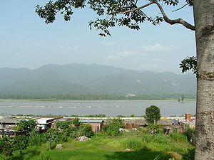
Baitadi District
Baitadi district , historical name “Bairath” , a part of Mahakali zone, is one of the seventy-five districts of Nepal, a landlocked country of South Asia. The district, with Baitadi as its district headquarters, covers an area of 1,519 km² and has a population of 234,418. The Baitadi...
in the center and the outer Terai
Terai
The Terai is a belt of marshy grasslands, savannas, and forests located south of the outer foothills of the Himalaya, the Siwalik Hills, and north of the Indo-Gangetic Plain of the Ganges, Brahmaputra and their tributaries. The Terai belongs to the Terai-Duar savanna and grasslands ecoregion...
in the South.
The name of this zone is derived from the Kali River.
Geography
The Boundary of this Region was Kali river on the west and Seti ZoneSeti Zone
Seti ZoneSeti ZoneSeti ZoneSeti ZoneSeti ZoneSeti ZoneSeti ZoneSeti ZoneSeti Zone' onMouseout='HidePop("87346")' href="/topics/Sugauli_Treaty">Sugauli Treaty
(also spelled Segowlee) was signed on December 2, 1815 and ratified on March 4, 1816, between the British East India Company and The Kingdom of Nepal, Kali river became the international boundary with Uttrakhand of India . The zone involves Coldest Byans to hottest Kanchanpur. Api Himalaya Lies on this zone from where Chameliya river originates.
Mahakali Zone is divided into four districts:
 Mahakali Zone of Nepal has a distinct language, culture and history. Various dialects of Kumauni language are spoken in this region. Even in the Kanchanpur District 80% of the people speak Kumauni language. Dotiyali dialect of Kumauni language is spoken in Dadeldhura District
and Baitada
dialect of Kumauni language is spoken in Baitadi and Darchula districts.
Gora is a famous festival observed in Mahakali Zone.
In ancient times, this region was a part of the Katyuri kingdom. After its collapse, this zone became a part of Doti kingdom, a branch of the Katyuri Kings
. Brahmadev Mandir in Kanchanpur District was built during the reign of the Katyuri king Brahmadev.
, which is also the headquarter of Kanchanpur district. Other main towns of Mahakali Zone are Dashrathchand, Patan (Baitadi)and Darchula Bajar.
The Amargadhi, the district headquarter, is named after General Amarshing Thapa (a famous Gorkha General) who formed a fort to expand Gorkha Empire capturing Kumaoun state after had defeated in previous war with Kumaoun during 1790 A.D.
in Kanchanpur District
in the Terai
, which covers an area of 305 km2 and surrounded by a buffer zone of 243.5 km2.
Sugauli Treaty
The Sugauli Treaty was signed on December 2, 1815 and ratified by March 4, 1816, between the British East India Company and Nepal, which was a kingdom during that era. This ended the second British invasion of the Himalayan kingdom during the Anglo-Nepalese War...
(also spelled Segowlee) was signed on December 2, 1815 and ratified on March 4, 1816, between the British East India Company and The Kingdom of Nepal, Kali river became the international boundary with Uttrakhand of India . The zone involves Coldest Byans to hottest Kanchanpur. Api Himalaya Lies on this zone from where Chameliya river originates.
Mahakali Zone is divided into four districts:
- Baitadi DistrictBaitadi DistrictBaitadi district , historical name “Bairath” , a part of Mahakali zone, is one of the seventy-five districts of Nepal, a landlocked country of South Asia. The district, with Baitadi as its district headquarters, covers an area of 1,519 km² and has a population of 234,418. The Baitadi...
with Baitadi as its headquarters, covers an area of 1,519 km2. - Dadeldhura DistrictDadeldhura DistrictDadeldhura district, a part of Mahakali zone, is one of the seventy-five districts of Nepal, a landlocked country of South Asia. The district, with Dadeldhura as its district headquarters, covers an area of 1,538km² and has a population of 126,162....
with DadeldhuraDadeldhuraDadeldhura is a Village Development Committee in Dadeldhura District in the Mahakali Zone of western Nepal.-External links:*...
as its headquarters, covers an area of 1,538 km2. - Darchula DistrictDarchula DistrictDarchula District of 121,996.The town has an Indian counterpart to its northwest, named Dharchula. The split between the two towns is just virtual as the traditions, culture, and lifestyle of the people living across both the regions are quite similar....
with DarchulaKhalanga, MahakaliKhalanga ' is a town and Village Development Committee in Darchula District in the Mahakali Zone of western Nepal. It is the district headquarters. At the time of the 1991 Nepal census it had a population of 4422 people living in 809 individual households.-External links:*...
as its headquarters, covers an area of 2,322 km2. - Kanchanpur DistrictKanchanpur District-Basic statistics:* District: Kanchanpur* Headquarters: Mahendranagar* Area: 1610 km²* Total Population: 377,899* Literacy rate: 57.60% -Political divisions:* Political constituencies: 4...
with Mahendranagar as its headquarters, covers an area of 1610 km2.
Language, culture and history
Dadeldhura District
Dadeldhura district, a part of Mahakali zone, is one of the seventy-five districts of Nepal, a landlocked country of South Asia. The district, with Dadeldhura as its district headquarters, covers an area of 1,538km² and has a population of 126,162....
and Baitada
Baitada
Baitada also Soradi is referred to the people of Baitadi district, of Nepal and also one of the dialect of Kumauni language spoken in the Baitadi District of Nepal or similar language spoken in other area like Darchula, Bhajhang , Dadeldhura , kanchanpur and kailali Districts of Nepal...
dialect of Kumauni language is spoken in Baitadi and Darchula districts.
Gora is a famous festival observed in Mahakali Zone.
In ancient times, this region was a part of the Katyuri kingdom. After its collapse, this zone became a part of Doti kingdom, a branch of the Katyuri Kings
Katyuri Kings
The Katyuri Kings were a medieval ruling clan of Uttarakhand believed to have descended from Shalivahan ruler from Ayodhya. This links them with Suryavansha...
. Brahmadev Mandir in Kanchanpur District was built during the reign of the Katyuri king Brahmadev.
Important cities
The largest city in the Mahakali Zone is MahendranagarMahendranagar
Bhim Dutta, formerly Mahendranagar , is a city and municipality in far western Nepal, six kilometres from the border of India and the Mahakali River...
, which is also the headquarter of Kanchanpur district. Other main towns of Mahakali Zone are Dashrathchand, Patan (Baitadi)and Darchula Bajar.
The Amargadhi, the district headquarter, is named after General Amarshing Thapa (a famous Gorkha General) who formed a fort to expand Gorkha Empire capturing Kumaoun state after had defeated in previous war with Kumaoun during 1790 A.D.
Protected areas
Mahakali Zone hosts the Sukla Phanta Wildlife ReserveSukla Phanta Wildlife Reserve
Sukla Phanta Wildlife Reserve is a protected area in the Terai of the Far-Western Region, Nepal, covering of open grassland, forests, riverbeds and tropical wetlands at an altitude of . It was gazetted in 1973 as Royal Sukla Phanta Wildlife Reserve...
in Kanchanpur District
Kanchanpur District
-Basic statistics:* District: Kanchanpur* Headquarters: Mahendranagar* Area: 1610 km²* Total Population: 377,899* Literacy rate: 57.60% -Political divisions:* Political constituencies: 4...
in the Terai
Terai
The Terai is a belt of marshy grasslands, savannas, and forests located south of the outer foothills of the Himalaya, the Siwalik Hills, and north of the Indo-Gangetic Plain of the Ganges, Brahmaputra and their tributaries. The Terai belongs to the Terai-Duar savanna and grasslands ecoregion...
, which covers an area of 305 km2 and surrounded by a buffer zone of 243.5 km2.
See also
- Zones of NepalZones of NepalNepal is divided into 14 administrative zones , and 75 districts . The 14 administrative zones are grouped into five development regions...
- Districts of NepalDistricts of NepalNepal's 14 administrative zones are subdivided into 75 districts . These districts are listed below, by zone...
- Regions of NepalRegions of NepalNepal is divided into 14 administrative zones , which are divided into 75 districts . The 14 administrative zones are grouped into five development regions...
- BaitadaBaitadaBaitada also Soradi is referred to the people of Baitadi district, of Nepal and also one of the dialect of Kumauni language spoken in the Baitadi District of Nepal or similar language spoken in other area like Darchula, Bhajhang , Dadeldhura , kanchanpur and kailali Districts of Nepal...
- DotiDotiFarwestern region of Nepal is also known as Doti or Doti region. The name Dotigarh has been used in the Jagar . This region is situated between River Kali boarding to the Uttarakhand in the west and Karnali river on the east...