
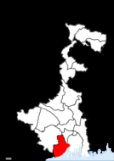
Purba Medinipur
Encyclopedia

District
Districts are a type of administrative division, in some countries managed by a local government. They vary greatly in size, spanning entire regions or counties, several municipalities, or subdivisions of municipalities.-Austria:...
in the India
India
India , officially the Republic of India , is a country in South Asia. It is the seventh-largest country by geographical area, the second-most populous country with over 1.2 billion people, and the most populous democracy in the world...
n state of West Bengal
West Bengal
West Bengal is a state in the eastern region of India and is the nation's fourth-most populous. It is also the seventh-most populous sub-national entity in the world, with over 91 million inhabitants. A major agricultural producer, West Bengal is the sixth-largest contributor to India's GDP...
. It is the southernmost district of Burdwan division
Burdwan Division
Burdwan Division is a division in the Indian state of West Bengal. It consists of 7 districts:* Bankura district* Bardhaman district* Birbhum district* East Midnapore * Hooghly district* Purulia district...
– one of the three administrative divisions
Divisions of West Bengal
The Indian state of Paschimbanga is divided into three administrative Divisions, namely:* Jalpaiguri division* Burdwan division* Presidency division...
of West Bengal. The headquarter is located at Tamluk
Tamluk
Tamluk is the district headquarters of Purba Medinipur district of West Bengal, India. Though there is some controversy, scholars have generally agreed that present day Tamluk is the site of the ancient city variously known as Tamralipta or Tamralipti...
. It was formed on January 1, 2002 after the Partition of Midnapore
Partition of Midnapore
The Partition of Midnapore was the administrative breakup of the Midnapore District of West Bengal, India into the western Paschim Medinipur and the eastern Purba Medinipur districts that became effective on January 1, 2002...
into Purba Medinipur and Paschim Medinipur
Paschim Medinipur
Paschim Medinipur district or West Midnapore district is the districts of the state of West Bengal, India. It was formed on January 1, 2002 after the Partition of Midnapore into Paschim Medinipur and Purba Medinipur. The district has 4 sub-divisions: Kharagpur, Medinipur Sadar, Ghatal and Jhargram...
which lies at the northern and western border of it. The state of Orissa
Orissa
Orissa , officially Odisha since Nov 2011, is a state of India, located on the east coast of India, by the Bay of Bengal. It is the modern name of the ancient nation of Kalinga, which was invaded by the Maurya Emperor Ashoka in 261 BC. The modern state of Orissa was established on 1 April...
is at the south-west border whereas the Bay of Bengal
Bay of Bengal
The Bay of Bengal , the largest bay in the world, forms the northeastern part of the Indian Ocean. It resembles a triangle in shape, and is bordered mostly by the Eastern Coast of India, southern coast of Bangladesh and Sri Lanka to the west and Burma and the Andaman and Nicobar Islands to the...
lies in the south; the Hooghly river and South 24 Parganas district
South 24 Parganas district
South 24 Parganas district is an important district of West Bengal State with its district headquarters in Alipore. It has the urban fringe of Calcutta on one side and the remote riverine villages in the Sundarbans....
to the east and Howrah district
Howrah District
Howrah district is a district of the West Bengal state in eastern India. It has thousands of years of rich heritage in the form of the great Bengali kingdom of Bhurshut. The district is named after its headquarters, the city of Howrah.-Geography:...
to the north-east.
Purba Medinipur is formed of the sub-divisions of Tamluk, Contai and Haldia of erstwhile Midnapore district
Midnapore District
Midnapore district is a former district of the state of West Bengal, India. This district was bifurcated on January 1, 2002 into the Purba Medinipur district and the Paschim Medinipur district.-References:...
. Another sub-division, Egra has been created out of the erstwhile Contai sub-division during the partition of Midnapore. In 2011, the state government has proposed to rename the district as Tamralipta district after the ancient port city of Tamralipta
Tamralipta
Tamralipta or Tamralipti was the name of an ancient city on the Bay of Bengal believed by scholars to be on the site of Tamluk in modern-day India.-References:...
which used to lie near the modern district headquarter.
Purba Medinipur saw many political movements during the British Raj
British Raj
British Raj was the British rule in the Indian subcontinent between 1858 and 1947; The term can also refer to the period of dominion...
. A parallel government named the Tamralipta Jatiya Sarkar was formed during the Quit India Movement
Quit India Movement
The Quit India Movement , or the August Movement was a civil disobedience movement launched in India in August 1942 in response to Mohandas Gandhi's call for immediate independence. Gandhi hoped to bring the British government to the negotiating table...
in Tamluk. In 2007, Purba Medinipur witnessed the Nandigram violence
Nandigram violence
The Nandigram violence was an incident in Nandigram in the West Bengal state of India, where, to curb the terror build by All India Trinamool Congress and Maoists, on the orders of the West Bengal government, police entered the Nandigram area and violence erupted...
, an incident of police firing that killed 14 farmers.
Major cities and towns
Major cities and towns include: PanskuraPanskura
Panskura is a town, municipality and a Police station in Purba Medinipur in the Indian state of West Bengal.-Geography:Panskura is located at . It has an average elevation of 7 metres . Its a situated on the NH6 on the way from Kolkata to Kharagpur.-Economy:The livelihood of the common people...
, Tamluk
Tamluk
Tamluk is the district headquarters of Purba Medinipur district of West Bengal, India. Though there is some controversy, scholars have generally agreed that present day Tamluk is the site of the ancient city variously known as Tamralipta or Tamralipti...
, Contai
Contai
Contai is head quarters of Contai subdivision in Purba Medinipur district, West Bengal, India. There are three community development blocks in Contai.- History :...
, Egra
Egra
Egra is head quarters of Egra subdivision in Purba Medinipur district in the state of West Bengal, India. it is a town with a municipality and community development blocks.-Geography:...
, Haldia
Haldia
Haldia has a typical moderate climate with winter temperatures ranging from a low of around 7 degrees Celsius to a high of 22 degrees Celsius. Winters are chilly and is when the residents hold the Haldia Utsav festival. Summers can be very hot and humid. Usual summer temperatures in May, the...
, Mecheda
Mecheda
Mecheda is a town in the West Bengal, India. The town is the gate way of Purba Medinipur Dist. upon S.E.Rly. and in proximity to Haldia, Tamluk, Digha and Midnapore.-Education:...
, Mahisadal, Nandigram
Nandigram
Nandigram is a rural area with two commuunity development blocks in Haldia subdivision of Purba Medinipur district of the Indian state of West Bengal. It is located about 70 km south-west of Kolkata, on the south bank of the Haldi River, opposite the industrial city of Haldia...
, Digha
Digha
Digha is a seaside resort town in the state of West Bengal, India. It lies in East Midnapore district and at the northern end of the Bay of Bengal. It is the most popular sea resort in the West Bengal....
, Mandarmani
Mandarmani
Mandarmani is a large and fast developing seaside resort village in the state of West Bengal, India. It lies in East Midnapore district and at the northern end of the Bay of Bengal. Mandarmani is connected to Kolkata/Howrah by a highway. It is argued to be the longest driveable beach in...
, Khejuri, Ramnagar
Ramnagar, West Bengal
Ramnagar I is an administrative division in Contai subdivision of Purba Medinipur district in the Indian state of West Bengal. Digha and Ramnagar police stations serve this block...
, Patashpur
Patashpur
Patashpur I is an administrative division in Egra subdivision of Purba Medinipur district in the Indian state of West Bengal. Patashpur police station serves this block...
, Bhagabanpur
Bhagabanpur
Bhagabanpur I is an administrative division in Egra subdivision of Purba Medinipur district in the Indian state of West Bengal. Bhagabanpur police station serves this block. Headquarters of this block is at Kajlagarh.-History:Bhagwanpur is a historical place...
, Manglamarro, Chandipur
Chandipur, Purba Medinipur
Chandipur is an administrative division in Tamluk subdivision of Purba Medinipur district in the Indian state of West Bengal. Chandipur police station serves this block...
, Nandaigajan, Kolaghat
Kolaghat
Kolaghat is a census town situated on the banks of the Rupnarayan River in the Midnapore East district of West Bengal. It is located in the Panskura–II community development block of the Tamluk subdivision. It is also the headquarters of the Panskura–II CD block...
and Paniparul.
Economy
In 2006 the Ministry of Panchayati RajMinistry of Panchayati Raj
The Ministry of Panchayati Raj is a branch of the Government of India looking after the ongoing process of decentralization and local governance in the States....
named Purba Medinipur one of the country's 250 most backward districts
Poverty in India
Poverty is widespread in India, with the nation estimated to have a third of the world's poor. According to a 2005 World Bank estimate, 41.6% of the total Indian population falls below the international poverty line of 1.25 a day...
(out of a total of 640
Districts of India
A district is an administrative division of an Indian state or territory. Districts are further subdivided, in some cases into Sub-Divisions, and otherwise directly into tehsils or talukas.District officials include:...
). It is one of the eleven districts in West Bengal currently receiving funds from the Backward Regions Grant Fund Programme (BRGF).
Administrative subdivisions
The district comprises four subdivisions: Tamluk, Haldia, Egra and Contai. Tamluk subdivision consists of TamlukTamluk
Tamluk is the district headquarters of Purba Medinipur district of West Bengal, India. Though there is some controversy, scholars have generally agreed that present day Tamluk is the site of the ancient city variously known as Tamralipta or Tamralipti...
municipality, Panskura
Panskura
Panskura is a town, municipality and a Police station in Purba Medinipur in the Indian state of West Bengal.-Geography:Panskura is located at . It has an average elevation of 7 metres . Its a situated on the NH6 on the way from Kolkata to Kharagpur.-Economy:The livelihood of the common people...
municipality and seven community development blocks: Nandakumar, Mayna, Tamluk, Shahid Matangini, Panskura–I, Panskura–II and Chandipur (Nadigram–III). Haldia subdivision consists of Haldia
Haldia
Haldia has a typical moderate climate with winter temperatures ranging from a low of around 7 degrees Celsius to a high of 22 degrees Celsius. Winters are chilly and is when the residents hold the Haldia Utsav festival. Summers can be very hot and humid. Usual summer temperatures in May, the...
municipality and five community development blocks: Mahisadal, Nandigram–I, Nandigram–II, Sutahata and Haldia. Egra subdivision consists of Egra
Egra
Egra is head quarters of Egra subdivision in Purba Medinipur district in the state of West Bengal, India. it is a town with a municipality and community development blocks.-Geography:...
municipality and six community development blocks: Bhagawanpur–I, Bhagawanpur–II, Egra–I, Egra–II, Pataspur–I and Pataspur–II. Contai subdivision consists of Contai
Contai
Contai is head quarters of Contai subdivision in Purba Medinipur district, West Bengal, India. There are three community development blocks in Contai.- History :...
municipality and seven community development blocks: Kanthi–I, Kanthi–II, Kanthi–III, Khejuri–I, Khejuri–II, Ramnagar–I and Ramnagar–II.
Tamluk
Tamluk
Tamluk is the district headquarters of Purba Medinipur district of West Bengal, India. Though there is some controversy, scholars have generally agreed that present day Tamluk is the site of the ancient city variously known as Tamralipta or Tamralipti...
is the district headquarters. There are 21 police stations, 25 development blocks, 5 municipalities and 223 gram panchayat
Gram panchayat
Gram panchayats are local self-governments at the village or small town level in India. As of 2002 there were about 265,000 gram panchayats in India. The gram panchayat is the foundation of the Panchayat System. A gram panchayat can be set up in villages with minimum population of 300...
s in this district.
Other than municipality area, each subdivision contains community development blocks which in turn are divided into rural areas and census towns. In total there are 10 urban units: 5 municipalities and 5 census town
Census town
In India, a census town is one which has:# A minimum population of 5,000# At least 75% of male working population engaged in non-agricultural pursuits# A density of population of at least 400 persons per km2.In Ireland, a census town is;...
s. Panskura municipality was established in 2001.
Tamluk subdivision
- Two municipalities: TamlukTamlukTamluk is the district headquarters of Purba Medinipur district of West Bengal, India. Though there is some controversy, scholars have generally agreed that present day Tamluk is the site of the ancient city variously known as Tamralipta or Tamralipti...
and PanskuraPanskuraPanskura is a town, municipality and a Police station in Purba Medinipur in the Indian state of West Bengal.-Geography:Panskura is located at . It has an average elevation of 7 metres . Its a situated on the NH6 on the way from Kolkata to Kharagpur.-Economy:The livelihood of the common people...
. - Nandakumar community development block consists of rural areas only with 12 gram panchayats.
- MoynaMoynaMoyna is an administrative division in Tamluk subdivision of Purba Medinipur district in the Indian state of West Bengal. Moyna and Nandakumar police stations serve this block. Headquarters of this block is at Mayna...
community development block consists of rural areas with 11 gram panchayats and one census town: GoasafatGoasafatGoasafat is a census town in Purba Medinipur district in the Indian state of West Bengal.-Demographics: India census, Bargoda had a population of 5,406. Males constitute 52% of the population and females 48%. Goasafat has an average literacy rate of 65%, higher than the national average of 59.5%:...
. - Tamluk community development block consists of rural areas with 12 gram panchayats and one census town: Dakshin BaguanDakshin BaguanDakshin Baguan is a census town in Purba Medinipur district in the state of West Bengal, India.-Demographics: India census, Dakshin Baguan had a population of 4672. Males constitute 52% of the population and females 48%. Dakshin Baguan has an average literacy rate of 69%, higher than the national...
. - Shahid Matangini community development block consists of rural areas with 10 gram panchayats and one census town: KakdihiKakdihiKakdihi is a census town in Purba Medinipur district in the Indian state of West Bengal.-Demographics: India census, Kakdihi had a population of 4879. Males constitute 52% of the population and females 48%. Kakdihi has an average literacy rate of 76%, higher than the national average of 59.5%:...
. - Panskura–I community development block consists of rural areas with 14 gram panchayats and one census town: Bahirgram.
- Panskura–II community development block consists of rural areas with 13 gram panchayats and one census town: KolaghatKolaghatKolaghat is a census town situated on the banks of the Rupnarayan River in the Midnapore East district of West Bengal. It is located in the Panskura–II community development block of the Tamluk subdivision. It is also the headquarters of the Panskura–II CD block...
. - ChandipurChandipur, Purba MedinipurChandipur is an administrative division in Tamluk subdivision of Purba Medinipur district in the Indian state of West Bengal. Chandipur police station serves this block...
(Nadigram–III) community development block consists of rural areas only with 10 gram panchayats. - barkshimpur one of the most historical place
Haldia subdivision
- One municipality: HaldiaHaldiaHaldia has a typical moderate climate with winter temperatures ranging from a low of around 7 degrees Celsius to a high of 22 degrees Celsius. Winters are chilly and is when the residents hold the Haldia Utsav festival. Summers can be very hot and humid. Usual summer temperatures in May, the...
. - Mahisadal community development block consists of rural areas only with 11 gram panchayats.
- Nandigram–INandigramNandigram is a rural area with two commuunity development blocks in Haldia subdivision of Purba Medinipur district of the Indian state of West Bengal. It is located about 70 km south-west of Kolkata, on the south bank of the Haldi River, opposite the industrial city of Haldia...
community development block consists of rural areas only with 10 gram panchayats. - Nandigram–IINandigramNandigram is a rural area with two commuunity development blocks in Haldia subdivision of Purba Medinipur district of the Indian state of West Bengal. It is located about 70 km south-west of Kolkata, on the south bank of the Haldi River, opposite the industrial city of Haldia...
community development block consists of rural areas only with 7 gram panchayats. - SutahataSutahataSutahata is an administrative division in Haldia subdivision of Purba Medinipur district in the Indian state of West Bengal. In earlier days this block was referred to as Sutahata I block, and Haldia block was referred to as Sutahata II block. Sutahata and Durgachak police stations serve this block...
community development block consists of rural areas only with 6 gram panchayats. - Haldia community development block consists of rural areas only with 4 gram panchayats.
Egra subdivision
- One municipality: EgraEgraEgra is head quarters of Egra subdivision in Purba Medinipur district in the state of West Bengal, India. it is a town with a municipality and community development blocks.-Geography:...
. - Bhagabanpur–IBhagabanpurBhagabanpur I is an administrative division in Egra subdivision of Purba Medinipur district in the Indian state of West Bengal. Bhagabanpur police station serves this block. Headquarters of this block is at Kajlagarh.-History:Bhagwanpur is a historical place...
community development block consists of rural areas only with 10 gram panchayats. - Bhagabanpur–IIBhagabanpurBhagabanpur I is an administrative division in Egra subdivision of Purba Medinipur district in the Indian state of West Bengal. Bhagabanpur police station serves this block. Headquarters of this block is at Kajlagarh.-History:Bhagwanpur is a historical place...
community development block consists of rural areas only with 9 gram panchayats. - Egra–I community development block consists of rural areas only with 8 gram panchayats.
- Egra–II community development block consists of rural areas only with 8 gram panchayats.
- Pataspur–IPatashpurPatashpur I is an administrative division in Egra subdivision of Purba Medinipur district in the Indian state of West Bengal. Patashpur police station serves this block...
community development block consists of rural areas only with 9 gram panchayats. - Pataspur–IIPatashpurPatashpur I is an administrative division in Egra subdivision of Purba Medinipur district in the Indian state of West Bengal. Patashpur police station serves this block...
community development block consists of rural areas only with 7 gram panchayats.
Contai subdivision
- One municipality: ContaiContaiContai is head quarters of Contai subdivision in Purba Medinipur district, West Bengal, India. There are three community development blocks in Contai.- History :...
. - Kanthi–I community development block consists of rural areas only with 8 gram panchayats.
- Kanthi–II community development block consists of rural areas only with 8 gram panchayats.
- Kanthi–III community development block consists of rural areas only with 8 gram panchayats.
- Khejuri–I community development block consists of rural areas only with 6 gram panchayats.
- Khejuri–II community development block consists of rural areas only with 5 gram panchayats.
- Ramnagar–IRamnagar, West BengalRamnagar I is an administrative division in Contai subdivision of Purba Medinipur district in the Indian state of West Bengal. Digha and Ramnagar police stations serve this block...
community development block consists of rural areas only with 9 gram panchayats. - Ramnagar–IIRamnagar, West BengalRamnagar I is an administrative division in Contai subdivision of Purba Medinipur district in the Indian state of West Bengal. Digha and Ramnagar police stations serve this block...
community development block consists of rural areas only with 8 gram panchayats.
Demographics
According to the 2011 census2011 census of India
The 15th Indian National census was conducted in two phases, houselisting and population enumeration. Houselisting phase began on April 1, 2010 and involved collection of information about all buildings...
has a population
Demographics of India
The demographics of India are inclusive of the second most populous country in the world, with over 1.21 billion people , more than a sixth of the world's population. Already containing 17.5% of the world's population, India is projected to be the world's most populous country by 2025, surpassing...
of 5,094,238 , roughly equal to the United Arab Emirates
United Arab Emirates
The United Arab Emirates, abbreviated as the UAE, or shortened to "the Emirates", is a state situated in the southeast of the Arabian Peninsula in Western Asia on the Persian Gulf, bordering Oman, and Saudi Arabia, and sharing sea borders with Iraq, Kuwait, Bahrain, Qatar, and Iran.The UAE is a...
or the US state of Colorado
Colorado
Colorado is a U.S. state that encompasses much of the Rocky Mountains as well as the northeastern portion of the Colorado Plateau and the western edge of the Great Plains...
. This gives it a ranking of 20th in India (out of a total of 640
Districts of India
A district is an administrative division of an Indian state or territory. Districts are further subdivided, in some cases into Sub-Divisions, and otherwise directly into tehsils or talukas.District officials include:...
). The district has a population density of 1076 PD/sqkm . Its population growth rate
Family planning in India
Family planning in India is based on efforts largely sponsored by the Indian government. In the 1965-2009 period, contraceptive usage has more than tripled and the fertility rate has more than halved , but the national fertility rate is still high enough to cause long-term population growth...
over the decade 2001-2011 was 15.32 %. Purba Medinipur has a sex ratio
Sex ratio
Sex ratio is the ratio of males to females in a population. The primary sex ratio is the ratio at the time of conception, secondary sex ratio is the ratio at time of birth, and tertiary sex ratio is the ratio of mature organisms....
of 936 females
Women in India
The status of women in India has been subject to many great changes over the past few millennia. From equal status with men in ancient times through the low points of the medieval period, to the promotion of equal rights by many reformers, the history of women in India has been eventful...
for every 1000 males, and a literacy rate
Literacy in India
Literacy in India is key for socio-economic progress, and the Indian literacy rate grew to 74.04% in 2011 from 12% at the end of British rule in 1947. Although this was a greater than sixfold improvement, the level is well below the world average literacy rate of 84%, and India currently has the...
of 87.66 %.
Places of interest
- MandarmaniMandarmaniMandarmani is a large and fast developing seaside resort village in the state of West Bengal, India. It lies in East Midnapore district and at the northern end of the Bay of Bengal. Mandarmani is connected to Kolkata/Howrah by a highway. It is argued to be the longest driveable beach in...
- 13 km long sea beach near DighaDighaDigha is a seaside resort town in the state of West Bengal, India. It lies in East Midnapore district and at the northern end of the Bay of Bengal. It is the most popular sea resort in the West Bengal.... - DighaDighaDigha is a seaside resort town in the state of West Bengal, India. It lies in East Midnapore district and at the northern end of the Bay of Bengal. It is the most popular sea resort in the West Bengal....
- a beautiful sea beach