
Narayani Zone
Encyclopedia
Narayani
Narayani ' onMouseout='HidePop("18808")' href="/topics/Nepal">Nepal
, is one of the fourteen Zones of the Republic of Nepal
. Narayani Zone is named after the Narayani River which is located on the western border of the zone, separating it from Gandaki
and Lumbini
zones. Narayani means beloved of Narayan and Narayan refers to Lord Bishnu
(The preserver).
contains parts of the Terai
, Inner Terai
, and Hill regions of Nepal, but it does not contain any of the Mountain or Himalayan region. Narayani is rich in flora and fauna. Considering the plain Terai, bordering India (to the south), where Arnas (Wild Bulls) run to the Hills from when fall falls, landscape structure of Narayani can be considered pretty unique.
Narayani River and Rapti River are the main rivers of Narayani zone. Bisharari Lake, Garuda Lake are some of the few lakes in Narayani.
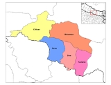
Narayani is divided into 5 districts:
Narayani is one of the few zones that has been left relatively untouched by Maoist insurgency up to now. It is one of the relatively prosperous zones of Nepal with a vibrant trading market with India whose effect can be easily seen in the border town of Birgunj. Birgunj is the capital of this zone.
See also:
Narayani ' onMouseout='HidePop("18808")' href="/topics/Nepal">Nepal
Nepal
Nepal , officially the Federal Democratic Republic of Nepal, is a landlocked sovereign state located in South Asia. It is located in the Himalayas and bordered to the north by the People's Republic of China, and to the south, east, and west by the Republic of India...
, is one of the fourteen Zones of the Republic of Nepal
Nepal
Nepal , officially the Federal Democratic Republic of Nepal, is a landlocked sovereign state located in South Asia. It is located in the Himalayas and bordered to the north by the People's Republic of China, and to the south, east, and west by the Republic of India...
. Narayani Zone is named after the Narayani River which is located on the western border of the zone, separating it from Gandaki
Gandaki
Gandaki may refer to:*Gandaki River, Nepal*Gandaki Zone, Nepal...
and Lumbini
Lumbini
Lumbinī is a Buddhist pilgrimage site in the Rupandehi district of Nepal. It is the place where Queen Mayadevi gave birth to Siddhartha Gautama, who as the Buddha Gautama founded the Buddhist tradition. The Buddha lived between roughly 563 and 483 BCE...
zones. Narayani means beloved of Narayan and Narayan refers to Lord Bishnu
Vishnu
Vishnu is the Supreme god in the Vaishnavite tradition of Hinduism. Smarta followers of Adi Shankara, among others, venerate Vishnu as one of the five primary forms of God....
(The preserver).
Geography
NarayaniNarayani
Narayani may refer to:* Narayani River, Nepalese name for the Gandaki River* Narayani Zone, one of fourteen administrative zones in Nepal* Narayani , Hindu Goddess...
contains parts of the Terai
Terai
The Terai is a belt of marshy grasslands, savannas, and forests located south of the outer foothills of the Himalaya, the Siwalik Hills, and north of the Indo-Gangetic Plain of the Ganges, Brahmaputra and their tributaries. The Terai belongs to the Terai-Duar savanna and grasslands ecoregion...
, Inner Terai
Inner Terai Valleys of Nepal
The Inner Terai Valleys or Bhitri tarai are various elongated valleys in Nepal situated between the Himalayan foothills, the 600–900 m high Siwalik or Churia Range and the 2,000-3,000 m high Mahabharat Range further north. Major examples are the Chitwan Valley southwest of Kathmandu and the...
, and Hill regions of Nepal, but it does not contain any of the Mountain or Himalayan region. Narayani is rich in flora and fauna. Considering the plain Terai, bordering India (to the south), where Arnas (Wild Bulls) run to the Hills from when fall falls, landscape structure of Narayani can be considered pretty unique.
Narayani River and Rapti River are the main rivers of Narayani zone. Bisharari Lake, Garuda Lake are some of the few lakes in Narayani.
Narayani is divided into 5 districts:
- Bara DistrictBara DistrictBara District of 559,135. Pasaha, Dudhaura and Bangari are the main rivers of Bara. Gamahariya is one of the villages of Bara District which is situated near the border area of India....
- Chitwan DistrictChitwan DistrictChitwan District and one sub-Metropolitan city - Bharatpur and a municipality Ratnanagar each of which has more than nine wards or urban areas....
- Makwanpur DistrictMakwanpur DistrictMakwanpur District of 392,604. Bhimfedi market of the district was the traditional route to enter Kathmandu valley from the south.-Village Development Committees :*Agara*Ambhanjyang*Bajrabarahi*Basamadi*Betini*Bhaise*Bharta Pundyadevi*Bhimfedi...
- Parsa DistrictParsa District-Village Development Committees :*Alau*Amarpatti*Auraha*Bagahi*Bagbana*Bageswori*Bahauri Pidari*Bahurbamatha*Basadilwa*Basantpur*Belwa Parsouni*Beriya Birta*Bhawanipur*Bhedihari*Bhisawa*Bijbaniya*Bindabasini*Biranchibarba*Birganj...
- Rautahat DistrictRautahat District-Village Development Committees :*Ajagabi*Akolawa*Auraiya*Badharwa*Bagahi*Bahuwa Madanpur*Bairiya*Banjaraha*Bariyarpur*Basantapatti*Basatpur*Basbiti Jingadiya*Bhalohiya*Bhediyahi*Birtipraskota*Bishrampur*Bisunpurwa Manpur*Brahmapuri...
History
Narayani used to be all forest, and settlement started after the Anglo-Nepal War. Devghat is also present in this area where people go there for meditation, it is one of the most religious place of Nepal.Miscellaneous
Narayani hosts Nepal's oldest and most famous national park: Chitwan (932 km²), considered to be one of Asia's richest nature reserves, renowned for its Bengal tigers and the Indian white Rhinoceros. To the southeast the park is complemented by the Parsa Wildlife reserve with another 499 km².Narayani is one of the few zones that has been left relatively untouched by Maoist insurgency up to now. It is one of the relatively prosperous zones of Nepal with a vibrant trading market with India whose effect can be easily seen in the border town of Birgunj. Birgunj is the capital of this zone.
See also:
- Zones of NepalZones of NepalNepal is divided into 14 administrative zones , and 75 districts . The 14 administrative zones are grouped into five development regions...
- Districts of NepalDistricts of NepalNepal's 14 administrative zones are subdivided into 75 districts . These districts are listed below, by zone...
- Regions of NepalRegions of NepalNepal is divided into 14 administrative zones , which are divided into 75 districts . The 14 administrative zones are grouped into five development regions...