
1936 Atlantic hurricane season
Encyclopedia
The 1936 Atlantic hurricane season officially began on June 16, 1936, and lasted until October 31, 1936. These dates conventionally delimit the period of each year when most tropical cyclone
s form in the Atlantic basin
.
The 1936 season
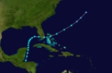
was fairly active, with 17 tropical cyclones including a tropical depression. Seven storms became hurricanes, of which one became a major hurricane. Despite the activity, conditions were generally unfavorable throughout the season. In addition, the season was unusual in the fact that no storms moved across large portions of the Caribbean Sea
. Seven storms, including three hurricanes, struck the United States
. The season also set many records for the earliest date for a numbered storm, though all were surpassed by the extreme activity of the 2005 season
.
coast of Guatemala
. It moved northeastward across Central America
, and entered the western Caribbean Sea
on June 11. The storm quickly re-organized, and again developed into a tropical storm on June 12. It moved north-northeastward, resulting in light winds as it paralleled the eastern coasts of Belize
and the Yucatan Peninsula
. After reaching the Gulf of Mexico
with peak winds of 45 miles per hour (72.4 km/h), the storm turned to the northeast, then to the east. On June 15, the tropical storm made landfall about 20 miles (32.2 km) to the south of Fort Myers, Florida
, and after crossing the state it passed over Miami
before entering the Atlantic Ocean
. It weakened as it accelerated northeastward through the Bahamas, and on June 17 the system dissipated to the north of Bermuda
.
While crossing Central America, the storm produced heavy rainfall. In southern Florida
, winds from the storm ranged from 30 miles per hour (48.3 km/h) to a peak of 39 miles per hour (62.8 km/h) in Miami. The storm produced heavy rainfall in southern Florida, ranging from 8 to 15 inches (200 to 380 mm). The rainfall caused flooding of highways and lowlands, drowned several livestock, and some damage. The storm caused three indirect deaths when a Coast Guard
airplane crashed in Tampa Bay
while in search of small boats.
on June 18. It tracked west-northwestward, and developed into a tropical storm the following day. The storm continued to the west-northwest until June 21, when the storm turned to the west-southwest. Having remained a minimal tropical storm for all of its lifetime, the 40-mph (70-km/h) storm struck northeast Mexico
on June 21, and dissipated the next day. The storm caused higher than normal tides along the Texas
coastline, and no damage or deaths were reported.
. It moved northwestward and rapidly strengthened, attaining hurricane status with peak winds of 80 miles per hour (128.7 km/h) by early on June 27. Later on June 27, the hurricane made landfall near Port Aransas
with a pressure of 990 mbar. The storm rapidly weakened over land, and dissipated on June 28 near San Antonio
. A small craft warning was issued for the Corpus Christi
area on the morning of the storm making landfall, and the National Weather Bureau
issued a Hurricane Warning
just 45 minutes prior to the hurricane striking land.
Upon making landfall, the storm caused a 3.8-foot (1.2-m) storm tide
, and many small boats were capsized or driven ahore. The hurricane produced wind gusts of up to 90 miles per hour (144.8 km/h) in Ingleside
and up to 80 miles per hour (128.7 km/h) in Port Aransas, destroying cooling towers at a local oil refinery and damaging a few houses. Along its path, the storm produced heavy rainfall, though specifics are unknown. Severe crop damage was reported in San Patricio and Nueces Counties. In all, the hurricane caused $550,000 in damage (1936 USD, $8 million 2006 USD), primarily to oil refinery property, though no deaths or injuries were reported.
from a tropical disturbance. It moved quickly northwestward, then turned northward, reaching a peak intensity of 45 miles per hour (72.4 km/h). On July 27, the storm accelerated northeastward and made landfall on southeastern Louisiana
with a pressure of 1003 mbar. The storm rapidly weakened over land and dissipated late on the 27th. The Weather Bureau office issued a storm warning for the Louisiana coastline, advising those potentially affected to prepare for strong winds and rising tides. However, the storm caused no serious damage, and no casualties are associated with the storm.
and became a hurricane on July 30. The hurricane continued to strengthen, and hit the western Florida Panhandle
with peak winds of 90 miles per hour (144.8 km/h) on July 31. It weakened rapidly over land, and dissipated over western Alabama
on August 1.
In south Florida, the storm caused a storm tide of 5.5 feet (1.7 m) when it made landfall, causing flooding of up to 1.5 foot (0.4572 m) in coastal areas. Though winds reached 60 miles per hour (96.6 km/h), damage was minimal there. In Valparaiso
in the Florida Panhandle, the hurricane produced wind gusts of up to 100 miles per hour (160.9 km/h), along with a storm tide of 6 feet (1.8 m). Damage from the storm was relatively minor, totaling to $123,000 (1936 USD, $1.78 million 2006 USD). The hurricane indirectly killed four people when a boat capsized in the Gulf of Mexico.
. It tracked northwestward, and reached a peak intensity of 45 miles per hour (72.4 km/h) on August 5. On August7, it weakened to minimal storm status, which was followed by a turn to the northeast on August 8. On August 9, the storm passed 160 miles (257.5 km) to the west of Bermuda
, and early on August 10 the storm became extratropical over the open Atlantic Ocean
. The extratropical storm continued northeastward until dissipating late on August 10 while 280 miles (450.6 km) south of the eastern tip of Nova Scotia
. The storm never affected land.
. The system moved northwest towards the northwest Gulf of Mexico
through August 9 while maintaining its peak of 40 miles per hour (64.4 km/h). The storm then began to curve more to the west-southwest on August 10 while located just south-southwest of Port Eads, Louisiana
while maintaining intensity. The storm continued moving southwest through August 11, weakening to a tropical depression shortly before making landfall near Tampico
on August 12. The system weakened quickly after moving inland, and dissipated shortly afterwards.
Advisories were issued early on August 12 from the U.S. Weather Bureau in New Orleans
for the system as it neared Mexico shortly before making landfall, but little damage and no deaths were reported in Mexico.
near Cancún
on August 15. The system moved northwest into the southwest Gulf of Mexico
as a tropical storm on August 16 while slowly strengthening. The system reached hurricane intensity as a Category 1
on August 17, and reached its peak of 80 miles per hour (128.7 km/h) shortly afterwards. The hurricane began to move west-southwest late on August 17 and through August 18, eventually making landfall near Tampico
on August 19 as a 75 miles per hour (120.7 km/h) minimal hurricane. The system quickly weakened just after moving inland and dissipated on the same day.
The hurricane brought heavy rains to mainland Mexico
, while the highest winds recorded at Tampico were 30 miles per hour (48.3 km/h) on August 19 as the center passed nearby just to the north. Storm warnings were issued on August 17 and 18 as the system initially approached the upper Gulf Coast
of Louisiana
and Texas
, but the system's west-southwest turn prevented a direct United States
landfall.
. Moving slowly west-northwest through August 21, the system strengthened to its peak of 50 miles per hour (80.5 km/h) later on August 21, and made landfall on August 22 near Daytona Beach
at its peak intensity. The system maintained tropical storm intensity inland while slowly weakening and moving westward, and the storm eventually weakened to a depression on August 23 while entering the eastern Florida Panhandle
, and the system dissipated shortly afterwards near as it drifted over eastern Mississippi
.
The storm caused heavy rains across northern and central Florida, and winds of 40 miles per hour (64.4 km/h) were recorded near TitusvilleTropical cyclone
A tropical cyclone is a storm system characterized by a large low-pressure center and numerous thunderstorms that produce strong winds and heavy rain. Tropical cyclones strengthen when water evaporated from the ocean is released as the saturated air rises, resulting in condensation of water vapor...
s form in the Atlantic basin
Atlantic Basin
The Atlantic Basin is the Atlantic Ocean.Atlantic Basin may also refer to:* Atlantic Basin Iron Works, an ironworks that operated in Brooklyn, New York, in the early to mid-20th century...
.
The 1936 season
Atlantic hurricane season
The Atlantic hurricane season is the period in a year when hurricanes usually form in the Atlantic Ocean. Tropical cyclones in the North Atlantic are called hurricanes, tropical storms, or tropical depressions. In addition, there have been several storms over the years that have not been fully...
was fairly active, with 17 tropical cyclones including a tropical depression. Seven storms became hurricanes, of which one became a major hurricane. Despite the activity, conditions were generally unfavorable throughout the season. In addition, the season was unusual in the fact that no storms moved across large portions of the Caribbean Sea
Caribbean Sea
The Caribbean Sea is a sea of the Atlantic Ocean located in the tropics of the Western hemisphere. It is bounded by Mexico and Central America to the west and southwest, to the north by the Greater Antilles, and to the east by the Lesser Antilles....
. Seven storms, including three hurricanes, struck the United States
United States
The United States of America is a federal constitutional republic comprising fifty states and a federal district...
. The season also set many records for the earliest date for a numbered storm, though all were surpassed by the extreme activity of the 2005 season
2005 Atlantic hurricane season
The 2005 Atlantic hurricane season was the most active Atlantic hurricane season in recorded history, repeatedly shattering numerous records. The impact of the season was widespread and ruinous with an estimated 3,913 deaths and record damage of about $159.2 billion...
.
Tropical Storm One
On June 9, a tropical storm made landfall on the PacificPacific Ocean
The Pacific Ocean is the largest of the Earth's oceanic divisions. It extends from the Arctic in the north to the Southern Ocean in the south, bounded by Asia and Australia in the west, and the Americas in the east.At 165.2 million square kilometres in area, this largest division of the World...
coast of Guatemala
Guatemala
Guatemala is a country in Central America bordered by Mexico to the north and west, the Pacific Ocean to the southwest, Belize to the northeast, the Caribbean to the east, and Honduras and El Salvador to the southeast...
. It moved northeastward across Central America
Central America
Central America is the central geographic region of the Americas. It is the southernmost, isthmian portion of the North American continent, which connects with South America on the southeast. When considered part of the unified continental model, it is considered a subcontinent...
, and entered the western Caribbean Sea
Caribbean Sea
The Caribbean Sea is a sea of the Atlantic Ocean located in the tropics of the Western hemisphere. It is bounded by Mexico and Central America to the west and southwest, to the north by the Greater Antilles, and to the east by the Lesser Antilles....
on June 11. The storm quickly re-organized, and again developed into a tropical storm on June 12. It moved north-northeastward, resulting in light winds as it paralleled the eastern coasts of Belize
Belize
Belize is a constitutional monarchy and the northernmost country in Central America. Belize has a diverse society, comprising many cultures and languages. Even though Kriol and Spanish are spoken among the population, Belize is the only country in Central America where English is the official...
and the Yucatan Peninsula
Yucatán Peninsula
The Yucatán Peninsula, in southeastern Mexico, separates the Caribbean Sea from the Gulf of Mexico, with the northern coastline on the Yucatán Channel...
. After reaching the Gulf of Mexico
Gulf of Mexico
The Gulf of Mexico is a partially landlocked ocean basin largely surrounded by the North American continent and the island of Cuba. It is bounded on the northeast, north and northwest by the Gulf Coast of the United States, on the southwest and south by Mexico, and on the southeast by Cuba. In...
with peak winds of 45 miles per hour (72.4 km/h), the storm turned to the northeast, then to the east. On June 15, the tropical storm made landfall about 20 miles (32.2 km) to the south of Fort Myers, Florida
Fort Myers, Florida
Fort Myers is the county seat and commercial center of Lee County, Florida, United States. Its population was 62,298 in the 2010 census, a 29.23 percent increase over the 2000 figure....
, and after crossing the state it passed over Miami
Miami, Florida
Miami is a city located on the Atlantic coast in southeastern Florida and the county seat of Miami-Dade County, the most populous county in Florida and the eighth-most populous county in the United States with a population of 2,500,625...
before entering the Atlantic Ocean
Atlantic Ocean
The Atlantic Ocean is the second-largest of the world's oceanic divisions. With a total area of about , it covers approximately 20% of the Earth's surface and about 26% of its water surface area...
. It weakened as it accelerated northeastward through the Bahamas, and on June 17 the system dissipated to the north of Bermuda
Bermuda
Bermuda is a British overseas territory in the North Atlantic Ocean. Located off the east coast of the United States, its nearest landmass is Cape Hatteras, North Carolina, about to the west-northwest. It is about south of Halifax, Nova Scotia, Canada, and northeast of Miami, Florida...
.
While crossing Central America, the storm produced heavy rainfall. In southern Florida
Florida
Florida is a state in the southeastern United States, located on the nation's Atlantic and Gulf coasts. It is bordered to the west by the Gulf of Mexico, to the north by Alabama and Georgia and to the east by the Atlantic Ocean. With a population of 18,801,310 as measured by the 2010 census, it...
, winds from the storm ranged from 30 miles per hour (48.3 km/h) to a peak of 39 miles per hour (62.8 km/h) in Miami. The storm produced heavy rainfall in southern Florida, ranging from 8 to 15 inches (200 to 380 mm). The rainfall caused flooding of highways and lowlands, drowned several livestock, and some damage. The storm caused three indirect deaths when a Coast Guard
United States Coast Guard
The United States Coast Guard is a branch of the United States Armed Forces and one of the seven U.S. uniformed services. The Coast Guard is a maritime, military, multi-mission service unique among the military branches for having a maritime law enforcement mission and a federal regulatory agency...
airplane crashed in Tampa Bay
Tampa Bay
Tampa Bay is a large natural harbor and estuary along the Gulf of Mexico on the west central coast of Florida, comprising Hillsborough Bay, Old Tampa Bay, Middle Tampa Bay, and Lower Tampa Bay."Tampa Bay" is not the name of any municipality...
while in search of small boats.
Tropical Storm Two
An area of disturbed weather was first detected near the Yucatan PeninsulaYucatán Peninsula
The Yucatán Peninsula, in southeastern Mexico, separates the Caribbean Sea from the Gulf of Mexico, with the northern coastline on the Yucatán Channel...
on June 18. It tracked west-northwestward, and developed into a tropical storm the following day. The storm continued to the west-northwest until June 21, when the storm turned to the west-southwest. Having remained a minimal tropical storm for all of its lifetime, the 40-mph (70-km/h) storm struck northeast Mexico
Mexico
The United Mexican States , commonly known as Mexico , is a federal constitutional republic in North America. It is bordered on the north by the United States; on the south and west by the Pacific Ocean; on the southeast by Guatemala, Belize, and the Caribbean Sea; and on the east by the Gulf of...
on June 21, and dissipated the next day. The storm caused higher than normal tides along the Texas
Texas
Texas is the second largest U.S. state by both area and population, and the largest state by area in the contiguous United States.The name, based on the Caddo word "Tejas" meaning "friends" or "allies", was applied by the Spanish to the Caddo themselves and to the region of their settlement in...
coastline, and no damage or deaths were reported.
Hurricane Three
A small tropical storm developed on June 26 while located 125 miles (201.2 km) east of Brownsville, TexasBrownsville, Texas
Brownsville is a city in the southernmost tip of the state of Texas, in the United States. It is located on the northern bank of the Rio Grande, directly north and across the border from Matamoros, Tamaulipas, Mexico. Brownsville is the 16th largest city in the state of Texas with a population of...
. It moved northwestward and rapidly strengthened, attaining hurricane status with peak winds of 80 miles per hour (128.7 km/h) by early on June 27. Later on June 27, the hurricane made landfall near Port Aransas
Port Aransas, Texas
Port Aransas is a city in Nueces County, Texas. The population was 3,370 at the 2000 census.-Early history:Karankawa Indians played a key role in the early development of the Texas Gulf Coast. The Karankawa Indians inhabited the Gulf Coast of Texas from Galveston Bay all the way to Corpus Christi Bay...
with a pressure of 990 mbar. The storm rapidly weakened over land, and dissipated on June 28 near San Antonio
San Antonio, Texas
San Antonio is the seventh-largest city in the United States of America and the second-largest city within the state of Texas, with a population of 1.33 million. Located in the American Southwest and the south–central part of Texas, the city serves as the seat of Bexar County. In 2011,...
. A small craft warning was issued for the Corpus Christi
Corpus Christi, Texas
Corpus Christi is a coastal city in the South Texas region of the U.S. state of Texas. The county seat of Nueces County, it also extends into Aransas, Kleberg, and San Patricio counties. The MSA population in 2008 was 416,376. The population was 305,215 at the 2010 census making it the...
area on the morning of the storm making landfall, and the National Weather Bureau
National Oceanic and Atmospheric Administration
The National Oceanic and Atmospheric Administration , pronounced , like "noah", is a scientific agency within the United States Department of Commerce focused on the conditions of the oceans and the atmosphere...
issued a Hurricane Warning
Tropical cyclone warnings and watches
Warnings and watches are two levels of alert issued by national weather forecasting bodies to coastal areas threatened by the imminent approach of a tropical cyclone of tropical storm or hurricane intensity. They are notices to the local population and civil authorities to make appropriate...
just 45 minutes prior to the hurricane striking land.
Upon making landfall, the storm caused a 3.8-foot (1.2-m) storm tide
Storm tide
A storm tide is a tide with a high flood period caused by a storm. Storm tides can be a severe danger to the coast and the people living along the coast. The water level can rise to more than 5 meters above the normal tide....
, and many small boats were capsized or driven ahore. The hurricane produced wind gusts of up to 90 miles per hour (144.8 km/h) in Ingleside
Ingleside, Texas
Ingleside is a town in Nueces and San Patricio Counties in the U.S. state of Texas. The population was 9,388 at the 2000 census.Ingleside is also home to Naval Station Ingleside. On August 24, 2005, the BRAC Committee voted to close the base. In 2010, the main base property was turned over to the...
and up to 80 miles per hour (128.7 km/h) in Port Aransas, destroying cooling towers at a local oil refinery and damaging a few houses. Along its path, the storm produced heavy rainfall, though specifics are unknown. Severe crop damage was reported in San Patricio and Nueces Counties. In all, the hurricane caused $550,000 in damage (1936 USD, $8 million 2006 USD), primarily to oil refinery property, though no deaths or injuries were reported.
Tropical Storm Four
On July 26, a small tropical storm formed near the western tip of CubaCuba
The Republic of Cuba is an island nation in the Caribbean. The nation of Cuba consists of the main island of Cuba, the Isla de la Juventud, and several archipelagos. Havana is the largest city in Cuba and the country's capital. Santiago de Cuba is the second largest city...
from a tropical disturbance. It moved quickly northwestward, then turned northward, reaching a peak intensity of 45 miles per hour (72.4 km/h). On July 27, the storm accelerated northeastward and made landfall on southeastern Louisiana
Louisiana
Louisiana is a state located in the southern region of the United States of America. Its capital is Baton Rouge and largest city is New Orleans. Louisiana is the only state in the U.S. with political subdivisions termed parishes, which are local governments equivalent to counties...
with a pressure of 1003 mbar. The storm rapidly weakened over land and dissipated late on the 27th. The Weather Bureau office issued a storm warning for the Louisiana coastline, advising those potentially affected to prepare for strong winds and rising tides. However, the storm caused no serious damage, and no casualties are associated with the storm.
Hurricane Five
A tropical storm was first observed over the southern Bahamas on July 27. It tracked to the west-northwest, and made landfall a short distance south of Everglades City, Florida with winds of 60 miles per hour (96.6 km/h). After crossing the state, it intensified over the eastern Gulf of MexicoGulf of Mexico
The Gulf of Mexico is a partially landlocked ocean basin largely surrounded by the North American continent and the island of Cuba. It is bounded on the northeast, north and northwest by the Gulf Coast of the United States, on the southwest and south by Mexico, and on the southeast by Cuba. In...
and became a hurricane on July 30. The hurricane continued to strengthen, and hit the western Florida Panhandle
Florida Panhandle
The Florida Panhandle, an informal, unofficial term for the northwestern part of Florida, is a strip of land roughly 200 miles long and 50 to 100 miles wide , lying between Alabama on the north and the west, Georgia also on the north, and the Gulf of Mexico to the south. Its eastern boundary is...
with peak winds of 90 miles per hour (144.8 km/h) on July 31. It weakened rapidly over land, and dissipated over western Alabama
Alabama
Alabama is a state located in the southeastern region of the United States. It is bordered by Tennessee to the north, Georgia to the east, Florida and the Gulf of Mexico to the south, and Mississippi to the west. Alabama ranks 30th in total land area and ranks second in the size of its inland...
on August 1.
In south Florida, the storm caused a storm tide of 5.5 feet (1.7 m) when it made landfall, causing flooding of up to 1.5 foot (0.4572 m) in coastal areas. Though winds reached 60 miles per hour (96.6 km/h), damage was minimal there. In Valparaiso
Valparaiso, Florida
Valparaiso is a city in Okaloosa County, Florida, in the United States, and it is named after the Chilean city of Valparaiso. As of the 2000 census, the city population was 6,408. According to the U.S. Census Bureau's 2004 estimates, the city had a population of 6,336...
in the Florida Panhandle, the hurricane produced wind gusts of up to 100 miles per hour (160.9 km/h), along with a storm tide of 6 feet (1.8 m). Damage from the storm was relatively minor, totaling to $123,000 (1936 USD, $1.78 million 2006 USD). The hurricane indirectly killed four people when a boat capsized in the Gulf of Mexico.
Tropical Storm Six
The sixth tropical storm of the season was first spotted on August 4 while located 155 miles (249.4 km) east-northeast of BarbudaBarbuda
Barbuda is an island in the Eastern Caribbean, and forms part of the state of Antigua and Barbuda. It has a population of about 1,500, most of whom live in the town of Codrington.-Location:...
. It tracked northwestward, and reached a peak intensity of 45 miles per hour (72.4 km/h) on August 5. On August7, it weakened to minimal storm status, which was followed by a turn to the northeast on August 8. On August 9, the storm passed 160 miles (257.5 km) to the west of Bermuda
Bermuda
Bermuda is a British overseas territory in the North Atlantic Ocean. Located off the east coast of the United States, its nearest landmass is Cape Hatteras, North Carolina, about to the west-northwest. It is about south of Halifax, Nova Scotia, Canada, and northeast of Miami, Florida...
, and early on August 10 the storm became extratropical over the open Atlantic Ocean
Atlantic Ocean
The Atlantic Ocean is the second-largest of the world's oceanic divisions. With a total area of about , it covers approximately 20% of the Earth's surface and about 26% of its water surface area...
. The extratropical storm continued northeastward until dissipating late on August 10 while 280 miles (450.6 km) south of the eastern tip of Nova Scotia
Nova Scotia
Nova Scotia is one of Canada's three Maritime provinces and is the most populous province in Atlantic Canada. The name of the province is Latin for "New Scotland," but "Nova Scotia" is the recognized, English-language name of the province. The provincial capital is Halifax. Nova Scotia is the...
. The storm never affected land.
Tropical Storm Seven
A weak tropical storm formed on August 7 in the eastern Gulf of Mexico west-northwest of the Dry TortugasDry Tortugas
The Dry Tortugas are a small group of islands, located at the end of the Florida Keys, USA, about west of Key West, and west of the Marquesas Keys, the closest islands. Still further west is the Tortugas Bank, which is completely submerged. The first Europeans to discover the islands were the...
. The system moved northwest towards the northwest Gulf of Mexico
Gulf of Mexico
The Gulf of Mexico is a partially landlocked ocean basin largely surrounded by the North American continent and the island of Cuba. It is bounded on the northeast, north and northwest by the Gulf Coast of the United States, on the southwest and south by Mexico, and on the southeast by Cuba. In...
through August 9 while maintaining its peak of 40 miles per hour (64.4 km/h). The storm then began to curve more to the west-southwest on August 10 while located just south-southwest of Port Eads, Louisiana
Port Eads, Louisiana
Port Eads, Louisiana, is located at the southern tip of the Mississippi River, also known as South Pass in Plaquemines Parish. It is the southern most point in Louisiana.-James Buchanan Eads:...
while maintaining intensity. The storm continued moving southwest through August 11, weakening to a tropical depression shortly before making landfall near Tampico
Tampico
Tampico is a city and port in the state of Tamaulipas, in the country of Mexico. It is located in the southeastern part of the state, directly north across the border from Veracruz. Tampico is the third largest city in Tamaulipas, and counts with a population of 309,003. The Metropolitan area of...
on August 12. The system weakened quickly after moving inland, and dissipated shortly afterwards.
Advisories were issued early on August 12 from the U.S. Weather Bureau in New Orleans
New Orleans, Louisiana
New Orleans is a major United States port and the largest city and metropolitan area in the state of Louisiana. The New Orleans metropolitan area has a population of 1,235,650 as of 2009, the 46th largest in the USA. The New Orleans – Metairie – Bogalusa combined statistical area has a population...
for the system as it neared Mexico shortly before making landfall, but little damage and no deaths were reported in Mexico.
Hurricane Eight
A tropical disturbance was detected in the western to northwest Caribbean SeaCaribbean Sea
The Caribbean Sea is a sea of the Atlantic Ocean located in the tropics of the Western hemisphere. It is bounded by Mexico and Central America to the west and southwest, to the north by the Greater Antilles, and to the east by the Lesser Antilles....
near Cancún
Cancún
Cancún is a city of international tourism development certified by the UNWTO . Located on the northeast coast of Quintana Roo in southern Mexico, more than 1,700 km from Mexico City, the Project began operations in 1974 as Integrally Planned Center, a pioneer of FONATUR Cancún is a city of...
on August 15. The system moved northwest into the southwest Gulf of Mexico
Gulf of Mexico
The Gulf of Mexico is a partially landlocked ocean basin largely surrounded by the North American continent and the island of Cuba. It is bounded on the northeast, north and northwest by the Gulf Coast of the United States, on the southwest and south by Mexico, and on the southeast by Cuba. In...
as a tropical storm on August 16 while slowly strengthening. The system reached hurricane intensity as a Category 1
Saffir-Simpson Hurricane Scale
The Saffir–Simpson Hurricane Scale , or the Saffir–Simpson Hurricane Wind Scale , classifies hurricanes — Western Hemisphere tropical cyclones that exceed the intensities of tropical depressions and tropical storms — into five categories distinguished by the intensities of their sustained winds...
on August 17, and reached its peak of 80 miles per hour (128.7 km/h) shortly afterwards. The hurricane began to move west-southwest late on August 17 and through August 18, eventually making landfall near Tampico
Tampico
Tampico is a city and port in the state of Tamaulipas, in the country of Mexico. It is located in the southeastern part of the state, directly north across the border from Veracruz. Tampico is the third largest city in Tamaulipas, and counts with a population of 309,003. The Metropolitan area of...
on August 19 as a 75 miles per hour (120.7 km/h) minimal hurricane. The system quickly weakened just after moving inland and dissipated on the same day.
The hurricane brought heavy rains to mainland Mexico
Mexico
The United Mexican States , commonly known as Mexico , is a federal constitutional republic in North America. It is bordered on the north by the United States; on the south and west by the Pacific Ocean; on the southeast by Guatemala, Belize, and the Caribbean Sea; and on the east by the Gulf of...
, while the highest winds recorded at Tampico were 30 miles per hour (48.3 km/h) on August 19 as the center passed nearby just to the north. Storm warnings were issued on August 17 and 18 as the system initially approached the upper Gulf Coast
Gulf Coast of the United States
The Gulf Coast of the United States, sometimes referred to as the Gulf South, South Coast, or 3rd Coast, comprises the coasts of American states that are on the Gulf of Mexico, which includes Texas, Louisiana, Mississippi, Alabama, and Florida and are known as the Gulf States...
of Louisiana
Louisiana
Louisiana is a state located in the southern region of the United States of America. Its capital is Baton Rouge and largest city is New Orleans. Louisiana is the only state in the U.S. with political subdivisions termed parishes, which are local governments equivalent to counties...
and Texas
Texas
Texas is the second largest U.S. state by both area and population, and the largest state by area in the contiguous United States.The name, based on the Caddo word "Tejas" meaning "friends" or "allies", was applied by the Spanish to the Caddo themselves and to the region of their settlement in...
, but the system's west-southwest turn prevented a direct United States
United States
The United States of America is a federal constitutional republic comprising fifty states and a federal district...
landfall.
Tropical Storm Nine
A weak tropical storm formed on August 20 near the eastern BahamasThe Bahamas
The Bahamas , officially the Commonwealth of the Bahamas, is a nation consisting of 29 islands, 661 cays, and 2,387 islets . It is located in the Atlantic Ocean north of Cuba and Hispaniola , northwest of the Turks and Caicos Islands, and southeast of the United States...
. Moving slowly west-northwest through August 21, the system strengthened to its peak of 50 miles per hour (80.5 km/h) later on August 21, and made landfall on August 22 near Daytona Beach
Daytona Beach, Florida
Daytona Beach is a city in Volusia County, Florida, USA. According to 2008 U.S. Census Bureau estimates, the city has a population of 64,211. Daytona Beach is a principal city of the Deltona – Daytona Beach – Ormond Beach, Florida Metropolitan Statistical Area, which the census bureau estimated had...
at its peak intensity. The system maintained tropical storm intensity inland while slowly weakening and moving westward, and the storm eventually weakened to a depression on August 23 while entering the eastern Florida Panhandle
Florida Panhandle
The Florida Panhandle, an informal, unofficial term for the northwestern part of Florida, is a strip of land roughly 200 miles long and 50 to 100 miles wide , lying between Alabama on the north and the west, Georgia also on the north, and the Gulf of Mexico to the south. Its eastern boundary is...
, and the system dissipated shortly afterwards near as it drifted over eastern Mississippi
Mississippi
Mississippi is a U.S. state located in the Southern United States. Jackson is the state capital and largest city. The name of the state derives from the Mississippi River, which flows along its western boundary, whose name comes from the Ojibwe word misi-ziibi...
.
Titusville, Florida
Titusville is a city in Brevard County, Florida in the United States. It is the county seat of Brevard County. Nicknamed Space City, USA, Titusville is on the Indian River, west of Merritt Island and the Kennedy Space Center and south-southwest of the Canaveral National Seashore...
. Overall damage was minimal.
Hurricane Ten
A tropical storm was detected on August 28 in the far western Caribbean Sea. The system moved steadily west-northwest, making landfall shortly afterwards on the Yucatan Peninsula as a 45 miles per hour (72.4 km/h) tropical storm. The system weakened slightly to a 40-mph (65-km/h) tropical storm as it steadily crossed the Yucatan, entering the Bay of CampecheBay of Campeche
The Bay of Campeche is the southern bight of the Gulf of Mexico. It is surrounded on three sides by the Mexican states of Campeche, Tabasco and Veracruz. It was named by Francisco Hernández de Córdoba and Antonio de Alaminos during their expedition in 1517...
late on August 28. The system then began to slow down on August 29 while reintensifying, peaking as an 80-mph (130-km/h) Category 1
Saffir-Simpson Hurricane Scale
The Saffir–Simpson Hurricane Scale , or the Saffir–Simpson Hurricane Wind Scale , classifies hurricanes — Western Hemisphere tropical cyclones that exceed the intensities of tropical depressions and tropical storms — into five categories distinguished by the intensities of their sustained winds...
shortly afterwards. The hurricane then began to move to the west-southwest, making a final landfall near Tuxpan
Tuxpan
Tuxpan is both a municipality and city located in the Mexican state of Veracruz. The population of the city was 78,523 and of the municipality was 134,394 inhabitants, according to the INEGI census of 2005, residing in a total area of 1,051.89 km²...
as a 75-mph (120-km/h) minimal hurricane on August 30. The system quickly weakened to a tropical storm shortly after moving inland, and the weakening storm dissipated shortly afterwards.
Although advisories were issued for Mexico on August 29 and early on August 30 from the U.S. Weather Bureau in New Orleans
New Orleans, Louisiana
New Orleans is a major United States port and the largest city and metropolitan area in the state of Louisiana. The New Orleans metropolitan area has a population of 1,235,650 as of 2009, the 46th largest in the USA. The New Orleans – Metairie – Bogalusa combined statistical area has a population...
, little overall damage was reported in mainland Mexico.
Hurricane Eleven
A hurricane was first detected in the eastern tropical AtlanticAtlantic Ocean
The Atlantic Ocean is the second-largest of the world's oceanic divisions. With a total area of about , it covers approximately 20% of the Earth's surface and about 26% of its water surface area...
on August 28. Moving northwest on August 29, the system continued to strengthen, eventually reaching a peak of 110 miles per hour (177 km/h) as a Category 2
Saffir-Simpson Hurricane Scale
The Saffir–Simpson Hurricane Scale , or the Saffir–Simpson Hurricane Wind Scale , classifies hurricanes — Western Hemisphere tropical cyclones that exceed the intensities of tropical depressions and tropical storms — into five categories distinguished by the intensities of their sustained winds...
hurricane in the central North Atlantic on September 1. The hurricane then began to curve northeast late on September 1 while maintaining intensity, eventually weakening to a 90 miles per hour (144.8 km/h) Category 1
Saffir-Simpson Hurricane Scale
The Saffir–Simpson Hurricane Scale , or the Saffir–Simpson Hurricane Wind Scale , classifies hurricanes — Western Hemisphere tropical cyclones that exceed the intensities of tropical depressions and tropical storms — into five categories distinguished by the intensities of their sustained winds...
hurricane on September 5. The system became extratropical on September 6, and the system dissipated while nearing the British Isles
British Isles
The British Isles are a group of islands off the northwest coast of continental Europe that include the islands of Great Britain and Ireland and over six thousand smaller isles. There are two sovereign states located on the islands: the United Kingdom of Great Britain and Northern Ireland and...
. As the system never affected land, no damage or casualties were reported.
Tropical Storm Twelve
On September 7, a ship reported southwest winds at a location about 405 miles (651.8 km) northeast of AntiguaAntigua
Antigua , also known as Waladli, is an island in the West Indies, in the Leeward Islands in the Caribbean region, the main island of the country of Antigua and Barbuda. Antigua means "ancient" in Spanish and was named by Christopher Columbus after an icon in Seville Cathedral, Santa Maria de la...
, indicating the presence of a tropical storm. The storm tracked to the west-northwest without strengthening, and the following day no circulation was reported. It is estimated the storm weakened to a tropical depression and dissipated on September 8 while located about 235 miles (378.2 km) north-northeast of Saint Martin
Saint Martin
Saint Martin is an island in the northeast Caribbean, approximately east of Puerto Rico. The 87 km2 island is divided roughly 60/40 between France and the Kingdom of the Netherlands ; however, the Dutch side has the larger population. It is one of the smallest sea islands divided between...
. The storm never affected land.
Hurricane Thirteen
A tropical storm was first observed by a ship on September 8 while located about 750 miles (1,207 km) east of BarbadosBarbados
Barbados is an island country in the Lesser Antilles. It is in length and as much as in width, amounting to . It is situated in the western area of the North Atlantic and 100 kilometres east of the Windward Islands and the Caribbean Sea; therein, it is about east of the islands of Saint...
. The storm moved northwestward, and slowly intensified to attain hurricane status on September 10 about 425 miles (684 km) northeast of Barbados. The hurricane continued to slowly strengthen as it decelerated its forward motion, and on September 15 it reached its peak intensity of 120 miles per hour (193.1 km/h) while located 375 miles (603.5 km) south-southwest of Bermuda
Bermuda
Bermuda is a British overseas territory in the North Atlantic Ocean. Located off the east coast of the United States, its nearest landmass is Cape Hatteras, North Carolina, about to the west-northwest. It is about south of Halifax, Nova Scotia, Canada, and northeast of Miami, Florida...
. By the morning of September 15, the hurricane had winds exceeding 25 miles per hour (40.2 km/h) in a diameter of about 1000 miles (1,609.3 km), among the largest tropical cyclones on record. It slowly weakened as it approached the East Coast of the United States
East Coast of the United States
The East Coast of the United States, also known as the Eastern Seaboard, refers to the easternmost coastal states in the United States, which touch the Atlantic Ocean and stretch up to Canada. The term includes the U.S...
, and early on September 17 local weather bureaus began issuing storm warnings
Tropical cyclone warnings and watches
Warnings and watches are two levels of alert issued by national weather forecasting bodies to coastal areas threatened by the imminent approach of a tropical cyclone of tropical storm or hurricane intensity. They are notices to the local population and civil authorities to make appropriate...
from Beaufort, North Carolina
Beaufort, North Carolina
Beaufort is a town in Carteret County, North Carolina, United States. Established in 1709, it is the third-oldest town in North Carolina.The population was 4,189 at the 2008 census and it is the county seat of Carteret County...
to the Virginia
Virginia
The Commonwealth of Virginia , is a U.S. state on the Atlantic Coast of the Southern United States. Virginia is nicknamed the "Old Dominion" and sometimes the "Mother of Presidents" after the eight U.S. presidents born there...
capes. Late on September 18, the hurricane passed within 45 miles (72.4 km) of the Outer Banks
Outer Banks
The Outer Banks is a 200-mile long string of narrow barrier islands off the coast of North Carolina, beginning in the southeastern corner of Virginia Beach on the east coast of the United States....
before it accelerated and turned to the northeast. It remained close to the Mid-Atlantic
Mid-Atlantic States
The Mid-Atlantic states, also called middle Atlantic states or simply the mid Atlantic, form a region of the United States generally located between New England and the South...
and New England
New England
New England is a region in the northeastern corner of the United States consisting of the six states of Maine, New Hampshire, Vermont, Massachusetts, Rhode Island, and Connecticut...
coastline, and passed near Nantucket before turning to the east-northeast. The hurricane remained south of Atlantic Canada
Atlantic Canada
Atlantic Canada is the region of Canada comprising the four provinces located on the Atlantic coast, excluding Quebec: the three Maritime provinces – New Brunswick, Prince Edward Island, and Nova Scotia – and Newfoundland and Labrador...
by a short distance, and became extratropical
Extratropical cyclone
Extratropical cyclones, sometimes called mid-latitude cyclones or wave cyclones, are a group of cyclones defined as synoptic scale low pressure weather systems that occur in the middle latitudes of the Earth having neither tropical nor polar characteristics, and are connected with fronts and...
on September 21 while located about 480 miles (772.5 km) east of Cape Race
Cape Race
Cape Race is a point of land located at the southeastern tip of the Avalon Peninsula on the island of Newfoundland, Canada. Its name is thought to come from the original Portuguese name for this cape, "Raso", or "bare"...
, Newfoundland. The extratropical storm decelerated as it turned northeastward, and the system dissipated on September 25.
In North Carolina
North Carolina
North Carolina is a state located in the southeastern United States. The state borders South Carolina and Georgia to the south, Tennessee to the west and Virginia to the north. North Carolina contains 100 counties. Its capital is Raleigh, and its largest city is Charlotte...
, the hurricane produced winds of up to 90 miles per hour (144.8 km/h) in Manteo
Manteo, North Carolina
Manteo is a town in Dare County, North Carolina, United States, located on Roanoke Island. The population was 1,052 at the 2000 census. It is the county seat of Dare County.-Geography:...
. Described as one of the worst hurricanes in record in Hatteras
Hatteras, North Carolina
Hatteras is an unincorporated community in Dare County, North Carolina, United States, on the Outer Banks island of Hatteras. North Carolina Highway 12 passes through the community linking it to Frisco and Ocracoke . It is south of the famous Cape Hatteras and the Cape Hatteras Lighthouse in Buxton...
, the storm resulted in $25,000 in damage (1936 USD, $360,000 2006 USD) to roads and bridges and $30,000 in damage (1936 USD, $440,000 2006 USD) to buildings and piers. Very high tides were reported along the Outer Banks
Outer Banks
The Outer Banks is a 200-mile long string of narrow barrier islands off the coast of North Carolina, beginning in the southeastern corner of Virginia Beach on the east coast of the United States....
, with Nags Head
Nags Head, North Carolina
Nags Head is a town in Dare County, North Carolina, United States. The population was 2,700 at the 2000 census.-History:Early maps of the area show Nags Head as a promontory of land characterized by high sand dunes visible from miles at sea...
losing about 35 feet (10.7 m) of beach. The hurricane destroyed the highway bridge along the Currituck Sound
Currituck Sound
Currituck Sound is a protected inlet of the Atlantic Ocean in northeastern part of North Carolina. Thirty miles N-S and 3–8 miles wide, this shallow, island-filled sound is separated from the ocean by Bodie Island, part of the Outer Banks...
, and resulted in heavy crop damage in northeastern North Carolina. The hurricane was also considered among the worst hurricanes on record in the Norfolk, Virginia
Norfolk, Virginia
Norfolk is an independent city in the Commonwealth of Virginia in the United States. With a population of 242,803 as of the 2010 Census, it is Virginia's second-largest city behind neighboring Virginia Beach....
area. Winds of up to 84 miles per hour (135.2 km/h) at Cape Henry
Cape Henry
Cape Henry is a cape on the Atlantic shore of Virginia north of Virginia Beach. It is the southern boundary of the entrance to Chesapeake Bay.Across the mouth of the bay to the north is Cape Charles...
destroyed windows, roofs, and some entire buildings, resulting in around $500,000 in damage (1936 USD, $7.3 million 2006 USD). The hurricane produced a storm tide of 9.3 feet (2.8 m) in Sewell's Point
Sewell's Point
Sewells Point is a peninsula of land in the independent city of Norfolk, Virginia in the United States, located at the mouth of the salt-water port of Hampton Roads. Sewells Point is bordered by water on three sides, with Willoughby Bay to the north, Hampton Roads to the west, and the Lafayette...
, the second highest on record at that location. Two locations along the James River
James River (Virginia)
The James River is a river in the U.S. state of Virginia. It is long, extending to if one includes the Jackson River, the longer of its two source tributaries. The James River drains a catchment comprising . The watershed includes about 4% open water and an area with a population of 2.5 million...
experienced record crest levels of over 20 feet (6.1 m). Rough seas washed several boats ashore, and shipping was cancelled in and out of Norfolk. The hurricane resulted in cancelled train service and increased traffic. The hurricane was indirectly responsible for two casualties. The first fatality occurred when debris from the hurricane struck a person in the head and later died. Another person drowned in the Elizabeth River
Elizabeth River (Virginia)
The Elizabeth River is a tidal estuary forming an arm of Hampton Roads harbor at the southern end of Chesapeake Bay in southeast Virginia in the United States. It is located along the southern side of the mouth of the James River, between the cities of Portsmouth and Norfolk...
in an effort to recover a rowboat blown adrift. Though hurricane warnings were posted for the northeast United States and hurricane force winds occurred there, damage, if any, is unknown.
Tropical Storm Fourteen
A tropical storm moved northward into AcapulcoAcapulco
Acapulco is a city, municipality and major sea port in the state of Guerrero on the Pacific coast of Mexico, southwest from Mexico City. Acapulco is located on a deep, semi-circular bay and has been a port since the early colonial period of Mexico’s history...
in the middle of September. Its large area of disturbed weather organized in the Bay of Campeche
Bay of Campeche
The Bay of Campeche is the southern bight of the Gulf of Mexico. It is surrounded on three sides by the Mexican states of Campeche, Tabasco and Veracruz. It was named by Francisco Hernández de Córdoba and Antonio de Alaminos during their expedition in 1517...
and developed into a tropical storm on September 10 a short distance off the coast of Tabasco
Tabasco
Tabasco officially Estado Libre y Soberano de Tabasco is one of the 31 states which, with the Federal District, comprise the 32 Federal Entities of Mexico. It is divided in 17 municipalities and its capital city is Villahermosa....
. The storm initially moved westward, then turned to the north. It remained a minimal tropical storm for its entire lifetime, and after turning to the north west it made landfall near Brownsville, Texas
Brownsville, Texas
Brownsville is a city in the southernmost tip of the state of Texas, in the United States. It is located on the northern bank of the Rio Grande, directly north and across the border from Matamoros, Tamaulipas, Mexico. Brownsville is the 16th largest city in the state of Texas with a population of...
on September 13 with winds of 45 miles per hour (72.4 km/h). The system weakened over Texas, and dissipated over northern Coahuila
Coahuila
Coahuila, formally Coahuila de Zaragoza , officially Estado Libre y Soberano de Coahuila de Zaragoza is one of the 31 states which, with the Federal District, comprise the 32 Federal Entities of Mexico...
on September 14. Winds were generally minor from the storm, and tides were not much above normal. The storm resulted in heavy rainfall though no reported damage. Anticipating further intensification, one bulletin from the local weather bureau recommended citizens on offshore islands to evacuate inland.
Hurricane Fifteen
A tropical storm was first observed about 140 miles (225.3 km) north of AnguillaAnguilla
Anguilla is a British overseas territory and overseas territory of the European Union in the Caribbean. It is one of the most northerly of the Leeward Islands in the Lesser Antilles, lying east of Puerto Rico and the Virgin Islands and directly north of Saint Martin...
on September 19. The storm moved northwestward and quickly attained hurricane status on September 20. After turning to the northeast, the hurricane reached a peak intensity of 110 miles per hour (177 km/h) on September 22 while located about 500 miles (804.7 km) southwest of Bermuda
Bermuda
Bermuda is a British overseas territory in the North Atlantic Ocean. Located off the east coast of the United States, its nearest landmass is Cape Hatteras, North Carolina, about to the west-northwest. It is about south of Halifax, Nova Scotia, Canada, and northeast of Miami, Florida...
. It turned to the north and slowly weakened. A cold front
Surface weather analysis
Surface weather analysis is a special type of weather map that provides a view of weather elements over a geographical area at a specified time based on information from ground-based weather stations...
turned the hurricane to the northeast, and the system became extratropical
Extratropical cyclone
Extratropical cyclones, sometimes called mid-latitude cyclones or wave cyclones, are a group of cyclones defined as synoptic scale low pressure weather systems that occur in the middle latitudes of the Earth having neither tropical nor polar characteristics, and are connected with fronts and...
on September 25 a short time before making landfall on southern Nova Scotia
Nova Scotia
Nova Scotia is one of Canada's three Maritime provinces and is the most populous province in Atlantic Canada. The name of the province is Latin for "New Scotland," but "Nova Scotia" is the recognized, English-language name of the province. The provincial capital is Halifax. Nova Scotia is the...
. Hours after hitting land, the extratropical remnant was absorbed by the approaching cold front. Impact, if any, is unknown.
Tropical Depression
A tropical depression formed in the western Atlantic OceanAtlantic Ocean
The Atlantic Ocean is the second-largest of the world's oceanic divisions. With a total area of about , it covers approximately 20% of the Earth's surface and about 26% of its water surface area...
on September 25. It moved west-northwestward, making landfall on eastern Florida
Florida
Florida is a state in the southeastern United States, located on the nation's Atlantic and Gulf coasts. It is bordered to the west by the Gulf of Mexico, to the north by Alabama and Georgia and to the east by the Atlantic Ocean. With a population of 18,801,310 as measured by the 2010 census, it...
before entering the Gulf of Mexico
Gulf of Mexico
The Gulf of Mexico is a partially landlocked ocean basin largely surrounded by the North American continent and the island of Cuba. It is bounded on the northeast, north and northwest by the Gulf Coast of the United States, on the southwest and south by Mexico, and on the southeast by Cuba. In...
on September 28. The depression turned to the northwest, and struck land near Apalachicola
Apalachicola, Florida
Apalachicola is a city in Franklin County, Florida, on US 98 about southwest of Tallahassee. The population was 2,334 at the 2000 census. The 2005 census estimated the city's population at 2,340...
as a minimal system. It dissipated over land on October 1. The minimum central pressure in the depression was 1006 mbar. The depression produced winds of up to 35 miles per hour (56.3 km/h) in Tarpon Springs
Tarpon Springs, Florida
Tarpon Springs is a city in Pinellas County, Florida, United States. The population was 21,003 at the 2000 census. According to the U.S. Census Bureau's 2004 estimates, the city had a population of 22,554....
. Effects were minimal.
Tropical Storm Sixteen
An area of disturbed weather persisted across the northwestern Caribbean SeaCaribbean Sea
The Caribbean Sea is a sea of the Atlantic Ocean located in the tropics of the Western hemisphere. It is bounded by Mexico and Central America to the west and southwest, to the north by the Greater Antilles, and to the east by the Lesser Antilles....
in early October. It tracked northwestward over the Yucatán Peninsula
Yucatán Peninsula
The Yucatán Peninsula, in southeastern Mexico, separates the Caribbean Sea from the Gulf of Mexico, with the northern coastline on the Yucatán Channel...
, and subsequent to the development of a low-level circulation the system organized into a tropical storm on October 9 while located about 60 miles (96.6 km) northwest of the capital
Campeche, Campeche
San Francisco de Campeche is the capital city of the Mexican state of Campeche, located at,...
of Campeche
Campeche
Campeche is one of the 31 states which, with the Federal District, comprise the 32 Federal Entities of Mexico. Located in Southeast Mexico, it is bordered by the states of Yucatán to the north east, Quintana Roo to the east, and Tabasco to the south west...
. After moving northward, the storm turned sharply southward, and made landfall in northern Tabasco
Tabasco
Tabasco officially Estado Libre y Soberano de Tabasco is one of the 31 states which, with the Federal District, comprise the 32 Federal Entities of Mexico. It is divided in 17 municipalities and its capital city is Villahermosa....
as a minimal tropical storm on October 10. The system quickly weakened over land, and dissipated over Chiapas
Chiapas
Chiapas officially Estado Libre y Soberano de Chiapas is one of the 31 states that, with the Federal District, comprise the 32 Federal Entities of Mexico. It is divided in 118 municipalities and its capital city is Tuxtla Gutierrez. Other important cites in Chiapas include San Cristóbal de las...
on October 11. The system dropped heavy rainfall across southeastern Mexico
Mexico
The United Mexican States , commonly known as Mexico , is a federal constitutional republic in North America. It is bordered on the north by the United States; on the south and west by the Pacific Ocean; on the southeast by Guatemala, Belize, and the Caribbean Sea; and on the east by the Gulf of...
, though damage, if any, is unknown.
Accumulated Cyclone Energy Rating (ACE)
The table below shows the ACEAccumulated cyclone energy
Accumulated cyclone energy is a measure used by the National Oceanic and Atmospheric Administration to express the activity of individual tropical cyclones and entire tropical cyclone seasons, particularly the North Atlantic hurricane season. It uses an approximation of the energy used by a...
for each storm in the season. Broadly speaking, the ACE is a measure of the power of the hurricane multiplied by the duration of its lifetime; thus, hurricanes that lasted a long time (such as Thirteen) have higher ACEs. Despite the high number of storms, most were relatively short-lived and weak, and the ACE only suggested a near-normal season. The ACE rating is only calculated for full advisories on tropical systems at or exceeding 35 kn (42.6 mph; 68.6 km/h) or tropical storm strength.
| ACE (104 kt²) – Storm | ||||||||
|---|---|---|---|---|---|---|---|---|
| 1 | Thirteen | 34.1 | 2 | Eleven | 25.1 | 3 | Fifteen | 14.6 |
| 4 | Eight | 7.43 | 5 | Five | 6.23 | 6 | Ten | 3.38 |
| 7 | Six | 3.04 | 8 | Seven | 2.70 | 9 | One | 2.58 |
| 10 | Three | 2.01 | 11 | Fourteen | 1.98 | 12 | Two | 1.47 |
| 13 | Nine | 1.38 | 14 | Four | .810 | 15 | Sixteen | .735 |
| 16 | Twelve | .490 | ||||||
| Total=108.035 (108) | ||||||||
See also
- List of tropical cyclones
- List of Atlantic hurricane seasons