

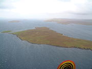
Yell Sound
Encyclopedia
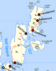
North Isles
The North Isles are the northern islands of the Shetland Islands, Scotland. The main islands in the group are Yell, Unst and Fetlar. Sometimes the islands in Yell Sound are included in this group.- Importance :...
and it contains many small islands. Sullom Voe
Sullom Voe
Sullom Voe is an inlet between North Mainland and Northmavine on Shetland in Scotland. It is a location of the Sullom Voe oil terminal. The word Voe is from the Old Norse vagr and denotes a small bay or narrow creek...
, on the shores of which is a substantial oil terminal, is an arm of Yell Sound.
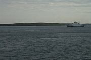
The ferry to the North Isles crosses the sound, which can experience strong tides and adverse weather conditions. There are numerous shipwreck sites and several lighthouse
Lighthouse
A lighthouse is a tower, building, or other type of structure designed to emit light from a system of lamps and lenses or, in older times, from a fire, and used as an aid to navigation for maritime pilots at sea or on inland waterways....
s to guide shipping. Yell Sound is mentioned briefly in the medieval Orkneyinga saga and during the 19th century there was a short flourishing of the kelp
Kelp
Kelps are large seaweeds belonging to the brown algae in the order Laminariales. There are about 30 different genera....
industry. Commercial fishing has long been a mainstay of the local economy and part of the sound is as Special Area of Conservation
Special Area of Conservation
A Special Area of Conservation is defined in the European Union's Habitats Directive , also known as the Directive on the Conservation of Natural Habitats and of Wild Fauna and Flora...
set up to protect the local wildlife.
Early history
The Old NorseOld Norse
Old Norse is a North Germanic language that was spoken by inhabitants of Scandinavia and inhabitants of their overseas settlements during the Viking Age, until about 1300....
name was Alasund although the original meaning of the name is not clear. Yell Sound is mentioned briefly in the Orkneyinga saga
Orkneyinga saga
The Orkneyinga saga is a historical narrative of the history of the Orkney Islands, from their capture by the Norwegian king in the ninth century onwards until about 1200...
:
- "Earl Rögnvald... and the chiefs Sölmond and Jón with him... had a fine body of troops, thought not too numerous, and five or six ships. They arrived at Hjaltland (Shetland) about the middle of Summer, but heard nothing of Frákork. Strong and contrary winds sprung up, and they brought their ships to Alasund (Yell Sound), and went a-feasting over the country."
Islands
The north western approaches to the sound are guarded by a series of small islands north of the Point of Fethland, which is the northernmost land of NorthmavineNorthmavine
Northmavine is a peninsula of Shetland in Scotland. It is in the north west of the island, and contains the villages of Hillswick, Ollaberry, and North Roe...
on the Shetland Mainland
Shetland Mainland
The Mainland is the main island of Shetland, Scotland. The island contains Shetland's only burgh, Lerwick, and is the centre of Shetland's ferry and air connections....
. The largest of these islands is Gruney
Gruney
Gruney is a small, uninhabited island in Shetland, Scotland. It lies north of the Northmavine peninsula of the Shetland Mainland, from which it is separated by the Gruney Sound....
and a small archipelago of reefs and skerries
Skerry
A skerry is a small rocky island, usually defined to be too small for habitation. It may simply be a rocky reef. A skerry can also be called a low sea stack....
lies north of there known as the Ramna Stacks
Ramna Stacks
The Ramna Stacks are a group of skerries in the Shetland islands. They are north of the northern tip of Mainland, and along with nearby Gruney they are a special protection area on account of their birdlife.From north to south they consist of:*Gaut Skerries...
including (from north to south) Gaut Skerries, Outer Stack, Scordar, Turla, Hyter, Ofoora, Fladda, Flae-ass, and Barlcudda.
Muckle Holm, Yell Sound
Muckle Holm is a small island in Shetland. It is in Yell Sound, near the Northmavine. It is 23m at its highest point.There is a lighthouse, first lit in 1976.-References:...
, and Little Holm
Little Holm, Yell Sound
Little Holm is a small island in Yell Sound, in Shetland. It lies between Northmavine and the Isle of Yell. There is a lighthouse here.In 1983, the Royal Navy cleared ordnance from the area, and their bomb disposal team discovered an unrecorded shipwreck nearby. Its identity is still not...
. Yell Sound narrows between Mio Ness on the Mainland and south Yell. The islands of Bigga
Bigga, Shetland
Bigga is an uninhabited island in the Sound of Yell between the Mainland and Yell in Shetland, Scotland.-Geography and geology:Just over long, Bigga is in size, and is tall at its highest point. Bigga is a long thin island with a "head" and a "torso"...
, Brother Isle
Brother Isle
Brother Isle is a small, uninhabited island in Shetland, Scotland. It lies between the islands of Yell and Shetland Mainland. It is in size.- Geography and geology :The island's rock is "undifferentiated moine gneiss and quartzite."- History :...
, Lamba
Lamba (island)
Lamba is an uninhabited island in Yell Sound in the Shetland Islands. It lies north of the entrance to the Sullom Voe inlet. Rising 35 metres above sea level, it has an area of . Its main features are a 27m high light marking the entrance to Sullom Voe, and an adjacent communications mast.There...
, Orfasay
Orfasay
Orfasay is one of the Shetland Islands.-Geography:Orfasay is a tidal island in Yell Sound, connected to Yell at low tide. This is reflected in the island's name....
, Little Roe
Little Roe
-History:The island's name is Norse in origin, from , meaning "small red island" in contradistinction to Muckle Roe, which is not nearby, but in St Magnus BayIn 1841, eleven people lived here, all in the same house.A light beacon has been built on the island....
, Samphrey
Samphrey
left|thumb|Samphrey and the view down [[Yell Sound]]Samphrey is an uninhabited island in the Shetland Islands, Scotland. One of Fair Isle's old names is "Friðarey" which is of similar origin....
and Uynarey
Uynarey
Uynarey is one of the Shetland islands in Yell Sound, just to the north of Bigga, and east of Brother Island. It is an RSPB reserve.The name comes from the Norse for "venerated island", and this may reflect a Culdee connection.-Geology and geography:...
lie in this part of the channel.
South of Firth Ness the sound widens and Fish Holm
Fish Holm
Fish Holm is a small island, east of Mainland, Shetland. It is near the village of Mossbank.It is at its highest point, and a mile south of Samphrey in Yell Sound.- References :*...
, Linga
Linga, Yell
Linga is a very small uninhabited island in the Bluemull Sound, Shetland, Scotland. It is one of many islands in Shetland called Linga. It has an area of 45 ha and is 26m at its highest point.-Geography and geology:...
, Setter Holm, Sinna Skerry, and Wether Holm are found here. The eastern approaches lie between Heoga Ness on Yell and Lunna Ness
Lunna Ness
Lunna Ness is a peninsula in the north east of Mainland, Shetland, in the parish of Lunnasting near Vidlin. The island of Lunna Holm is nearby. The Shetland Bus operation during WWII used this area as a base....
on the Mainland. Gold Skerry, Green Holm and Neapback Skerries lie off the former and Lunna Holm
Lunna Holm
Lunna Holm is a small island near Lunna Ness , in the Shetland Islands. It is at its highest point.The island also has a lighthouse.-References:*...
and Sand Skerry north of the latter.
Inlets
West Sandwick
West Sandwick is a settlement on the Isle of Yell, Shetland Islands. It is one of the few settlements in the west of the island.West Sandwick contains one of the major recreational beaches in Yell....
. The large bay of Hamna Voe is at the south end of Yell north of Orfasay island. The much smaller Burra Voe
Burra Voe
Burra Voe is sheltered bay at the southeast corner of the island of Yell.The village of Burravoe is on the north coast of Burra Voe.-Sources:* This article is based on http://shetlopedia.com/Burra_Voe GFDL wiki....
lies just to the east near the village of Burravoe
Burravoe
Burravoe, , is a community in the south-east part of Yell, on the north shore of Burra Voe, in the Shetland Islands.The most notable building is The Old Haa Museum which dates from 1672....
.
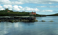
The village of North Roe
North Roe
North Roe is a village, and protected area at the northern tip in the large Northmavine peninsula of the Mainland of Shetland, Scotland. It is a small village, with a school with less than a dozen pupils in 2011. North Roe is internationally recognised wetland site, and it is protected under the...
is on the shores of a second Burra Voe on the north Mainland side of the sound. South of there is the larger Colla Firth, separated from Quey Firth by Ness of Queyfirth. Next are Ollaberry Bay
Ollaberry
Ollaberry is a settlement on Mainland, Shetland on the west shore of Yell Sound. The land round here is fertile by Shetland standards....
, Gluss Voe and Sullom Voe
Sullom Voe
Sullom Voe is an inlet between North Mainland and Northmavine on Shetland in Scotland. It is a location of the Sullom Voe oil terminal. The word Voe is from the Old Norse vagr and denotes a small bay or narrow creek...
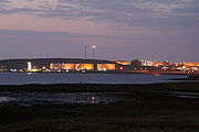
, which is a major inlet and at 12 kilometres (7.5 mi) the longest of Shetland's many voes (Old Norse: "bay"). It contains the Sullom Voe Terminal
Sullom Voe Terminal
The Sullom Voe Terminal is an oil and liquefied gas terminal at Sullom Voe in the Shetland Islands of Scotland. It handles production from oilfields in the North Sea and East Shetland Basin...
operated by BP plc
BP
BP p.l.c. is a global oil and gas company headquartered in London, United Kingdom. It is the third-largest energy company and fourth-largest company in the world measured by revenues and one of the six oil and gas "supermajors"...
and itself has numerous bays and inlets. Sullom Voe terminates at the extraordinary Mavis Grind
Mavis Grind
Mavis Grind is a narrow isthmus joining the Northmavine peninsula to the rest of the island of Shetland Mainland in the Shetland Islands, UK. It is just wide at its narrowest point...
, a narrow isthmus separating the North Sea
North Sea
In the southwest, beyond the Straits of Dover, the North Sea becomes the English Channel connecting to the Atlantic Ocean. In the east, it connects to the Baltic Sea via the Skagerrak and Kattegat, narrow straits that separate Denmark from Norway and Sweden respectively...
from the Atlantic Ocean
Atlantic Ocean
The Atlantic Ocean is the second-largest of the world's oceanic divisions. With a total area of about , it covers approximately 20% of the Earth's surface and about 26% of its water surface area...
.
Further south are Orka Voe, Tofts Voe, Firths Voe, Swinister Voe, Dales Voe, a second Colla Firth, Swining Voe, Lumna Voe and a second and smaller Hamna Voe with an inner bay called Boatsroom Voe.
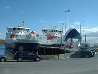
Ferries
Toft, Shetland
Toft is a ferry port approximately one mile north of Mossbank on Mainland, Shetland, Scotland. From here, a car ferry service to Ulsta on the island of Yell operates. Toft is located in the parish of Delting....
on the Mainland, and Ulsta
Ulsta
Ulsta is a village in the south-west of the island of Yell, Shetland, Scotland. The car ferry to Toft on Mainland, Shetland leaves from here.-References:*...
on Yell, the route being between the island of Samphrey to the east and Bigga to the north. Daggri and Dagalien are roll-on-roll-off ferries that have been operated since 2004 by Shetland Islands Council. Built in Gdansk
Gdansk
Gdańsk is a Polish city on the Baltic coast, at the centre of the country's fourth-largest metropolitan area.The city lies on the southern edge of Gdańsk Bay , in a conurbation with the city of Gdynia, spa town of Sopot, and suburban communities, which together form a metropolitan area called the...
, they are each 65 metres (213.3 ft) long, and are capable of carrying up to 95 passengers and 31 cars or 4 trucks. These boats have a registered tonnage in excess of six times that of the ships they replaced on the route and their increased size has significantly improved transport to the northern isles. The crossing takes about 20 minutes and the services operate at half-hourly intervals.
The first regular ferry to the North Isles was the Janet, which began operating from Lerwick
Lerwick
Lerwick is the capital and main port of the Shetland Islands, Scotland, located more than 100 miles off the north coast of mainland Scotland on the east coast of the Shetland Mainland...
in 1839. The steamer Chieftain's Bride was introduced to this route in 1868 and the SS Lady Ambrosine in 1876. The Earl of Zetland, an iron screw steamer of 253 tons, began a twice weekly Lerwick to Unst service with weekly visits to Out Skerries and the ports of Yell Sound. Originally the service called at numerous small villages in the sound, but after 1932 the stopping-off points were reduced in number due to competition. The ferry twice survived attacks by enemy aircraft during World War 2. A second and larger Earl of Zetland was brought into service after 1945. Weighing 548 tons and with a length of 47.2 metres (154.9 ft), the ship was popular with summer visitors but cargo was handled by a single derrick and a government subsidy of £100,000 per annum was required to support the operation.
Shipwrecks
The 18 ton wooden fishing smack Ellen was wrecked on the Rumble Rock, (between Samphrey and Orfasay) on 27 April 1896. In March 1904 the trawler Ibis was wrecked at the same location during a snowstorm, the crew being rescued by the trawler Sunbeam. In June 1914 the 50.2 metres (164.7 ft) steamer Robert Lea was grounded on Stoura Baa at the north end of Brother Isle en route from Colla Firth to Liverpool also without loss of life. In 1992 the wreck was located in 10 metres (32.8 ft) of water. The 22 metres (72.2 ft) fishing boat Morning Star sank approximately 1.5 kilometre (0.93205910497471 mi) north west of Muckle Holm lighthouse whilst under tow after a fire broke out in the engine room. In 1983, the Royal Navy
Royal Navy
The Royal Navy is the naval warfare service branch of the British Armed Forces. Founded in the 16th century, it is the oldest service branch and is known as the Senior Service...
cleared ordnance from Little Holm, and their bomb disposal team discovered an unrecorded shipwreck nearby. Its identity is still unknown. There are no protected shipwrecks in the sound.
Lighthouses
There are several lights operated by the Northern Lighthouse BoardNorthern Lighthouse Board
The Northern Lighthouse Board is the General Lighthouse Authority for Scotland and the Isle of Man. It is a non-departmental public body responsible for marine navigation aids around coastal areas.-History:...
guiding shipping in the sound. To the north Bagi Stack on Yell to the east, and Gruney and Point of Fethaland to the west are the outer lights. To the south, the outermost light is at Lunna Holm. Within the sound from north to south the lights are Muckle Holm, Little Holm, Lamba South, Outer Skerry, Brother Isle, Ness of Sound, Rumble Rock (since 2001) and Firths Voe on the Mainland.
Commercial activities
Haddock
The haddock , also known as the offshore hake, is a marine fish distributed on both sides of the North Atlantic. Haddock is a popular food fish and is widely fished commercially....
, herring
Herring
Herring is an oily fish of the genus Clupea, found in the shallow, temperate waters of the North Pacific and the North Atlantic oceans, including the Baltic Sea. Three species of Clupea are recognized. The main taxa, the Atlantic herring and the Pacific herring may each be divided into subspecies...
and crabs. The inner sound has commercial scallop
Scallop
A scallop is a marine bivalve mollusk of the family Pectinidae. Scallops are a cosmopolitan family, found in all of the world's oceans. Many scallops are highly prized as a food source...
beds and various fish and shellfish farms. The profusion of seaweeds including wrack (Fucus serratus) and tangle
Kelp
Kelps are large seaweeds belonging to the brown algae in the order Laminariales. There are about 30 different genera....
(Laminaria digitata) was briefly exploited for commercial purposes. Between 1870 and the end of the nineteenth century several hundred tons of kelp used in the production of iodine
Iodine
Iodine is a chemical element with the symbol I and atomic number 53. The name is pronounced , , or . The name is from the , meaning violet or purple, due to the color of elemental iodine vapor....
and bromine
Bromine
Bromine ") is a chemical element with the symbol Br, an atomic number of 35, and an atomic mass of 79.904. It is in the halogen element group. The element was isolated independently by two chemists, Carl Jacob Löwig and Antoine Jerome Balard, in 1825–1826...
were exported annually from Unst, Yell and the mainland shores of Yell Sound. The many small fires burning along the shores apparently made a lasting impression on visitors.
Away from the beaches, Yell Sound is little used for recreational purposes, possibly due to the relatively high volume of tonnage accessing Sullom Voe. As a primary navigation channel, the entire sound is under the control of Shetland Islands Council's Ports and Harbours Operations authority and has been identified as a body of water "At Risk" of not meeting the EU Water Framework Directive.
Wildlife
Part of the sound is as Special Area of ConservationSpecial Area of Conservation
A Special Area of Conservation is defined in the European Union's Habitats Directive , also known as the Directive on the Conservation of Natural Habitats and of Wild Fauna and Flora...
(SAC), in part due to the high concentration of Otters. The Shetland populations are possibly the densest in Europe and up to 2% of the British population may live in the site. The low-lying peat
Peat
Peat is an accumulation of partially decayed vegetation matter or histosol. Peat forms in wetland bogs, moors, muskegs, pocosins, mires, and peat swamp forests. Peat is harvested as an important source of fuel in certain parts of the world...
y coastlines provide easy access to fresh water, extensive algal beds in the marine environment and large numbers of otter holts. There is also a significant population of the Common Seal with the local colony representing over 1% of the UK population. Sullom Voe is a separate SAC, qualifying due to the numerous large shallow inlets and bays, coastal reefs and lagoons.
There are Horse mussel
Mussel
The common name mussel is used for members of several families of clams or bivalvia mollusca, from saltwater and freshwater habitats. These groups have in common a shell whose outline is elongated and asymmetrical compared with other edible clams, which are often more or less rounded or oval.The...
(Modiolus modiolus) beds both within Sullom Voe and on the Mainland coast near Colla Firth. Ceteceans are regularly sited in the inner sound, especially Harbour Porpoise
Harbour Porpoise
The harbour porpoise is one of six species of porpoise. It is one of the smallest marine mammals. As its name implies, it stays close to coastal areas or river estuaries, and as such, is the most familiar porpoise to whale watchers. This porpoise often ventures up rivers, and has been seen...
, Minke Whale
Minke Whale
Minke whale , or lesser rorqual, is a name given to two species of marine mammal belonging to a clade within the suborder of baleen whales. The minke whale was given its official designation by Lacepède in 1804, who described a dwarf form of Balænoptera acuto-rostrata...
and Killer Whale and there are a wide variety of breeding seabirds, divers and ducks including Eider
Eider
Eiders are large seaducks in the genus Somateria. Steller's Eider, despite its name, is in a different genus.The three extant species all breed in the cooler latitudes of the Northern hemisphere....
.
See also
- Balta SoundBalta SoundBalta Sound is a sound on the east coast of the island of Unst in the Shetland Islands, Scotland. The sound is sheltered from the North Sea to the east by the uninhabited island of Balta.The settlement at the west of the sound is Baltasound....
- Bluemull SoundBluemull SoundBluemull Sound is the strait between Unst and Yell in Shetland's North Isles. A ferry service crosses it regularly. Cullivoe is on the Yell side, and the island of Linga lies in the strait....
- Sounds of ScotlandSounds of ScotlandThis is a list of the Sounds of Scotland. These straits vary in size from substantial sea channels to the tiny Clachan Sound, which is only wide and spanned by the Clachan Bridge...
- List of Shetland islands