
Warrandyte, Victoria
Encyclopedia
Warrandyte is a suburb in Melbourne
, Victoria
, Australia
, 24 km north-east from Melbourne's central business district
. Its Local Government Area is the City of Manningham
. At the 2006 Census, Warrandyte had a population of 7393.
Warrandyte is bounded in the west by Mullum Creek and Target Road, in the north by the Yarra River
, in the east by Jumping Creek and Anzac Road, and in the south by an irregular line from Reynolds Road north of Donvale
, Park Orchards
and Warrandyte South
.
Warrandyte was founded as a Victorian town located in the once gold
-rich rolling hills east of Melbourne, Victoria, and is now on the north-eastern boundary of suburban Melbourne. Gold was first discovered in the town in 1851 and together with towns like Bendigo, Victoria
and Ballarat, Victoria
, led the way in gold discoveries during the Victorian gold rush
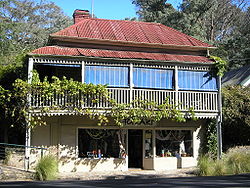
. Today Warrandyte retains much of its past in its surviving buildings of the Colonial period and remains a twin community with North Warrandyte
which borders the Yarra River
to its north.
Today the town and suburb is well known for its residents' positive attitude towards the environment
. Conservation programs run regularly and areas of land small and large have been set aside for conservation or ecological restoration purposes. The Warrandyte Festival
is held every year in mid March, a parade, live music, food and shopping stalls and kids activities are some of the things that can be seen at the festival, which is one of the last remaining volunteer-run festivals in Victoria
.
(see dreamtime
), a Wurundjeri
dreamtime
story tells of a great eagle; "the all powerful, ever watchful creator of the world" named Bunjil
, who "once gazed down upon his people from the star Altair and saw their wrong doing. Awaiting their return, with a mighty crash of thunder, he hurled down a star to destroy them". Where the star struck created a gorge in which much of the town today is located. Bunjil's people remembered the spot, and referred to it as Warrandyte speculated to mean "that which is thrown".
, Indigenous Australians
of the Kulin
nation, who spoke variations of the Woiwurrung
language group. Warrandyte was an important place to them as the geology formed a natural gorge which inspired many of the Wurundjeri dreamtime
stories, such as those associated with Bunjil
. They managed the land sustainably
for tens of thousands of years. One example of this can be found in the tradition whereby neighbouring clans agreed to cease fishing in the Yarra River
once fish populations became low; this gave the fish the opportunity to repopulate the area and prevented the human-induced extinction of any species. This principle was also applied to hunting and gathering on land and the use of trees.
. This marked the start of the Victorian gold rush
, however more substantial discoveries in the Ballarat and Bendigo region initially drew prospectors away from Warrandyte. While some mining did occur in the area throughout the peak of the gold rush, it wasn't until the late 19th century, after gold discoveries reduced in the more popular regions, that the area around Warrandyte was intensively mined, particularly around Fourth Hill and Whipstick Gully. Some areas continued to be mined up until the 1960s. Warrandyte Post Office opened on 1 August 1857.
Throughout Warrandyte the river shows signs of being exploited during this time, a classic example being the tunnel at Pound Bend. The river was partially dammed at Pound Bend near Normans Reserve at its eastern entrance and near Bob's wetlands at its western exit. Miners then blasted a 300m long tunnel through solid rock. The river was then fully dammed at the entrance and exit to the tunnel and water was diverted through 300m and out the other side leaving 3.85 km of riverbed around Pound Bend exposed, ready to be mined.
who sought subject matter further into the bush. This led to the development of an artists camp and small colony. Though not as substantial as the older colonies at Heidelberg and Box Hill
, several artists, such as Clara Southern
and Walter Withers
, who were associated with the Heidelberg School, took up residence in Warrandyte. Others followed, including Penleigh Boyd
, Harold Herbert and Jo Sweatman.
, Phyl Dunn, Gus McLaren
and Charles Wilton. Sylvia Halpern, Kate Janeeba and Elsa Ardern, joined the group in 1961 after the cottage had moved to a farmhouse at the corner of Jumping Creek and Ringwood-Warrandyte roads. The only non potter member being John Hipwell
an architect. The last member of the group was Peter Laycock, who joined in 1969. The cottage continued to operate until 2005.
into North Warrandyte. Prior to the construction of the Upper Yarra Dam, heavy downpours led to flood waters that washed away Warrandyte's punt downstream into Templestowe
, whose residents then decided to use it to cross the Yarra at the present day site of the Swingbridge near Oddesey House. The first bridge was built in Warrandyte in 1861 after much lobbying by residents. The majority of funding came from the government, with the difference made up by residents of Warrandye and North Warrandyte. Built entirely out of local timber, the bridge was located 5 mi east of the current bridge and stood for 90 years until the mid 1950s saw the current bridge constructed from new materials in Australia at the time: concrete
and iron
.
. The river and hills surrounding the town were once rich in gold, and the ruins of mineshafts and tunnels can be found throughout the Warrandyte State Park
amongst other locations. While the central town itself is nestled into a gorge on the river, the suburb covers a reasonably large area of land and can be divided up into the following sections:
into the Yarra just before the beginning of Pound Bend. This area is where several gullies
converge and create a geographical hole with Fourth Hill to the east and the hills on the eastern banks of the Mullum Mullum Creek to the west. This becomes evident when driving through Warrandyte on Heidelberg-Warrandyte Road, as the hills guide the road down towards Andersons Creek.
Vast areas of land around Warrandyte are governed by Parks Victoria or are privately owned such as Longridge Farm. These areas contain dense populations of many different varieties of Eucalyptus
Trees.
Warrandyte is home to or borders the following rivers and creeks:
Some geographical features that can be found in Warrandyte include:
, North Warrandyte
and Park Orchards
, however, due to Warrandyte's geographical position, it can at times be used to travel to and from other suburbs.
Peak hour traffic always flows to and from west and south of Warrandyte along its main roads, this traffic is either trying to get out of surrounding suburbs or to the Eastern Freeway.
Major local roads in Warrandyte include:
 Warrandyte is well known for its residents' positive attitude towards the environment. Conservation programs run regularly and areas of land small and large have been set aside for conservation or environmental restoration purposes. In homage to this community spirit, the Warrandyte Festival, one of the last remaining volunteer-run festivals in Victoria, is held every year in mid March. Typically, the festival features a variety of attractions. Many stalls sell local produce or crafts, and there are numerous historical exhibits, as well as safety demonstrations by the CFA
. A variety of live music stages are set up, with stages specifically catering for youth bands from the community. The festival parade is a feature of the festival, with bands, community orientated groups and schools all partaking in a morning march through the town.
Warrandyte contains a general post office, tennis courts, a community centre, an RSL, several Bed and Breakfast
s, restaurants, a police station, a CFA Fire Station, two kindergartens, two recreational ovals (AFL Football and Cricket), Warrandyte Community Church, Uniting and Anglican places of worship, Andersons Creek Cemetery and a Scout hall
, canoe launching ramps, a skatepark, nurseries and tearooms and the Crystal Brook Holiday Centre.
Educational Facilities in Warrandyte:
Shopping Strips & Centres in Warrandyte:
, canoeing, kayaking, skateboarding and bushwalking among many others.
Parks, Gardens and Reserves in Warrandyte:
Melbourne
Melbourne is the capital and most populous city in the state of Victoria, and the second most populous city in Australia. The Melbourne City Centre is the hub of the greater metropolitan area and the Census statistical division—of which "Melbourne" is the common name. As of June 2009, the greater...
, Victoria
Victoria (Australia)
Victoria is the second most populous state in Australia. Geographically the smallest mainland state, Victoria is bordered by New South Wales, South Australia, and Tasmania on Boundary Islet to the north, west and south respectively....
, Australia
Australia
Australia , officially the Commonwealth of Australia, is a country in the Southern Hemisphere comprising the mainland of the Australian continent, the island of Tasmania, and numerous smaller islands in the Indian and Pacific Oceans. It is the world's sixth-largest country by total area...
, 24 km north-east from Melbourne's central business district
Melbourne city centre
Melbourne City Centre is an area of Melbourne in Victoria, Australia. It is not to be confused with the larger local government area of the City of Melbourne...
. Its Local Government Area is the City of Manningham
City of Manningham
The City of Manningham is a Local Government Area in Victoria, Australia. It is located in the northeastern suburbs of Melbourne. The total population is 118,544 , divided up into 10 suburbs, the largest being Doncaster and Templestowe, over an area of 113 square kilometres.The district spans a...
. At the 2006 Census, Warrandyte had a population of 7393.
Warrandyte is bounded in the west by Mullum Creek and Target Road, in the north by the Yarra River
Yarra River
The Yarra River, originally Birrarung, is a river in east-central Victoria, Australia. The lower stretches of the river is where the city of Melbourne was established in 1835 and today Greater Melbourne dominates and influences the landscape of its lower reaches...
, in the east by Jumping Creek and Anzac Road, and in the south by an irregular line from Reynolds Road north of Donvale
Donvale, Victoria
Donvale is a suburb in Melbourne, Victoria, Australia, 20 km east from Melbourne's central business district. Its Local Government Area is the City of Manningham. At the 2006 Census, Donvale had a population of 11,667...
, Park Orchards
Park Orchards, Victoria
Park Orchards is a suburb in Melbourne, Victoria, Australia, 23 km north-east from Melbourne's central business district. Its Local Government Area is the City of Manningham. At the 2006 Census, Park Orchards had a population of 3590....
and Warrandyte South
Warrandyte South, Victoria
Warrandyte South is a locality within Greater Melbourne beyond the Melbourne metropolitan area Urban Growth Boundary, 24 km north-east from Melbourne's central business district. Its Local Government Area is the City of Manningham...
.
Warrandyte was founded as a Victorian town located in the once gold
Gold
Gold is a chemical element with the symbol Au and an atomic number of 79. Gold is a dense, soft, shiny, malleable and ductile metal. Pure gold has a bright yellow color and luster traditionally considered attractive, which it maintains without oxidizing in air or water. Chemically, gold is a...
-rich rolling hills east of Melbourne, Victoria, and is now on the north-eastern boundary of suburban Melbourne. Gold was first discovered in the town in 1851 and together with towns like Bendigo, Victoria
Bendigo, Victoria
Bendigo is a major regional city in the state of Victoria, Australia, located very close to the geographical centre of the state and approximately north west of the state capital Melbourne. It is the second largest inland city and fourth most populous city in the state. The estimated urban...
and Ballarat, Victoria
Ballarat, Victoria
Ballarat is a city in the state of Victoria, Australia, approximately west-north-west of the state capital Melbourne situated on the lower plains of the Great Dividing Range and the Yarrowee River catchment. It is the largest inland centre and third most populous city in the state and the fifth...
, led the way in gold discoveries during the Victorian gold rush
Victorian gold rush
The Victorian gold rush was a period in the history of Victoria, Australia approximately between 1851 and the late 1860s. In 10 years the Australian population nearly tripled.- Overview :During this era Victoria dominated the world's gold output...
. Today Warrandyte retains much of its past in its surviving buildings of the Colonial period and remains a twin community with North Warrandyte
North Warrandyte, Victoria
North Warrandyte is a suburb in Melbourne, Victoria, Australia, 25 km north-east from Melbourne's central business district. Its Local Government Area is the Shire of Nillumbik...
which borders the Yarra River
Yarra River
The Yarra River, originally Birrarung, is a river in east-central Victoria, Australia. The lower stretches of the river is where the city of Melbourne was established in 1835 and today Greater Melbourne dominates and influences the landscape of its lower reaches...
to its north.
Today the town and suburb is well known for its residents' positive attitude towards the environment
Environmentalism
Environmentalism is a broad philosophy, ideology and social movement regarding concerns for environmental conservation and improvement of the health of the environment, particularly as the measure for this health seeks to incorporate the concerns of non-human elements...
. Conservation programs run regularly and areas of land small and large have been set aside for conservation or ecological restoration purposes. The Warrandyte Festival
Festival
A festival or gala is an event, usually and ordinarily staged by a local community, which centers on and celebrates some unique aspect of that community and the Festival....
is held every year in mid March, a parade, live music, food and shopping stalls and kids activities are some of the things that can be seen at the festival, which is one of the last remaining volunteer-run festivals in Victoria
Victoria (Australia)
Victoria is the second most populous state in Australia. Geographically the smallest mainland state, Victoria is bordered by New South Wales, South Australia, and Tasmania on Boundary Islet to the north, west and south respectively....
.
Etymology
In Australian Aboriginal mythologyAustralian Aboriginal mythology
Australian Aboriginal myths are the stories traditionally performed by Aboriginal peoples within each of the language groups across Australia....
(see dreamtime
Dreamtime
In the animist framework of Australian Aboriginal mythology, The Dreaming is a sacred era in which ancestral Totemic Spirit Beings formed The Creation.-The Dreaming of the Aboriginal times:...
), a Wurundjeri
Wurundjeri
The Wurundjeri are a people of the Indigenous Australian nation of the Woiwurrung language group, in the Kulin alliance, who occupy the Birrarung Valley, its tributaries and the present location of Melbourne, Australia...
dreamtime
Dreamtime
In the animist framework of Australian Aboriginal mythology, The Dreaming is a sacred era in which ancestral Totemic Spirit Beings formed The Creation.-The Dreaming of the Aboriginal times:...
story tells of a great eagle; "the all powerful, ever watchful creator of the world" named Bunjil
Bunjil
In Australian Aboriginal mythology, Bunjil the eagle is a creator deity, culture hero and ancestral being. In the Kulin nation in central Victoria he was regarded as one of two moiety ancestors, the other being the trickster Crow. Bunjil has two wives and a son, Binbeal the rainbow. His brother...
, who "once gazed down upon his people from the star Altair and saw their wrong doing. Awaiting their return, with a mighty crash of thunder, he hurled down a star to destroy them". Where the star struck created a gorge in which much of the town today is located. Bunjil's people remembered the spot, and referred to it as Warrandyte speculated to mean "that which is thrown".
Pre-European settlement
The area was originally occupied by one or more clans of the WurundjeriWurundjeri
The Wurundjeri are a people of the Indigenous Australian nation of the Woiwurrung language group, in the Kulin alliance, who occupy the Birrarung Valley, its tributaries and the present location of Melbourne, Australia...
, Indigenous Australians
Indigenous Australians
Indigenous Australians are the original inhabitants of the Australian continent and nearby islands. The Aboriginal Indigenous Australians migrated from the Indian continent around 75,000 to 100,000 years ago....
of the Kulin
Kulin
The Kulin nation, was an alliance of five Indigenous Australian nations in Central Victoria, Australia, prior to European settlement. Their collective territory extended to around Port Phillip and Western Port, up into the Great Dividing Range and the Loddon and Goulburn River valleys. To their...
nation, who spoke variations of the Woiwurrung
Woiwurrung
Woiwurrung is an Indigenous Australian language spoken by some of the Kulin Nation clans, the Wurundjeri people, of Central Victoria, from Mount Baw Baw in the east to Mount Macedon, Sunbury and Gisborne in the west.The Woiwurrung clans inhabited the Yarra River, called Birrarung in Woiwurrung,...
language group. Warrandyte was an important place to them as the geology formed a natural gorge which inspired many of the Wurundjeri dreamtime
Dreamtime
In the animist framework of Australian Aboriginal mythology, The Dreaming is a sacred era in which ancestral Totemic Spirit Beings formed The Creation.-The Dreaming of the Aboriginal times:...
stories, such as those associated with Bunjil
Bunjil
In Australian Aboriginal mythology, Bunjil the eagle is a creator deity, culture hero and ancestral being. In the Kulin nation in central Victoria he was regarded as one of two moiety ancestors, the other being the trickster Crow. Bunjil has two wives and a son, Binbeal the rainbow. His brother...
. They managed the land sustainably
Sustainability
Sustainability is the capacity to endure. For humans, sustainability is the long-term maintenance of well being, which has environmental, economic, and social dimensions, and encompasses the concept of union, an interdependent relationship and mutual responsible position with all living and non...
for tens of thousands of years. One example of this can be found in the tradition whereby neighbouring clans agreed to cease fishing in the Yarra River
Yarra River
The Yarra River, originally Birrarung, is a river in east-central Victoria, Australia. The lower stretches of the river is where the city of Melbourne was established in 1835 and today Greater Melbourne dominates and influences the landscape of its lower reaches...
once fish populations became low; this gave the fish the opportunity to repopulate the area and prevented the human-induced extinction of any species. This principle was also applied to hunting and gathering on land and the use of trees.
Gold discovery and mining
In 1851, gold was first discovered in Victoria in Warrandyte at Anderson's Creek by Louis Michel, the approximate location of the site is marked by a cairn on Fourth Hill in the Warrandyte State ParkWarrandyte State Park
Warrandyte State Park is a state park, located in Warrandyte, east of Melbourne, Victoria on the banks of the Yarra River and surroundings. The park comprises 586 hectares of remnant bushland in various locations throughout Warrandyte and Wonga Park around Pound Bend, Fourth Hill, Black Flat, Yarra...
. This marked the start of the Victorian gold rush
Victorian gold rush
The Victorian gold rush was a period in the history of Victoria, Australia approximately between 1851 and the late 1860s. In 10 years the Australian population nearly tripled.- Overview :During this era Victoria dominated the world's gold output...
, however more substantial discoveries in the Ballarat and Bendigo region initially drew prospectors away from Warrandyte. While some mining did occur in the area throughout the peak of the gold rush, it wasn't until the late 19th century, after gold discoveries reduced in the more popular regions, that the area around Warrandyte was intensively mined, particularly around Fourth Hill and Whipstick Gully. Some areas continued to be mined up until the 1960s. Warrandyte Post Office opened on 1 August 1857.
Throughout Warrandyte the river shows signs of being exploited during this time, a classic example being the tunnel at Pound Bend. The river was partially dammed at Pound Bend near Normans Reserve at its eastern entrance and near Bob's wetlands at its western exit. Miners then blasted a 300m long tunnel through solid rock. The river was then fully dammed at the entrance and exit to the tunnel and water was diverted through 300m and out the other side leaving 3.85 km of riverbed around Pound Bend exposed, ready to be mined.
Artists' colony
In the early 20th century, Warrandyte became a popular destination for artists of the Heidelberg SchoolHeidelberg School
The Heidelberg School was an Australian art movement of the late 19th century. The movement has latterly been described as Australian Impressionism....
who sought subject matter further into the bush. This led to the development of an artists camp and small colony. Though not as substantial as the older colonies at Heidelberg and Box Hill
Box Hill artists' camp
The Box Hill artists’ camp was a site in Box Hill, Victoria, Australia favoured for plein air painting in the late 1880s by a group of artists who were part of a movement that later became known as the Heidelberg School....
, several artists, such as Clara Southern
Clara Southern
Clara Southern was an Australian artist associated with the Heidelberg School, also known as Australian Impressionism....
and Walter Withers
Walter Withers
Walter Herbert Withers was an Australian landscape artist and a member of the Heidelberg School of Australian impressionists.- Biography :...
, who were associated with the Heidelberg School, took up residence in Warrandyte. Others followed, including Penleigh Boyd
Penleigh Boyd
Theodore Penleigh Boyd was an Australian artist.Penleigh Boyd was a member of the Boyd artistic dynasty: his parents Arthur Merric Boyd and Emma Minnie Boyd were well-known artists of the day, and his brothers included Merric Boyd the ceramacist and the novelist Martin Boyd...
, Harold Herbert and Jo Sweatman.
Potters' Cottage
In 1958, a group of potters looking for a way of exhibiting and selling their wares, opened the Potters’ Cottage in a small miner’s hut near the Warrandyte bridge. The founding members were Artur Halpern, Reg PrestonReg Preston
Reg Preston studied sculpture at the Westminster School of Art in London, in 1938. At the beginning of WW2 he returned to Australia and spent three months in 1944 potting at the Melbourne Technical College with John A. Barnard Knight and Klytie Pate...
, Phyl Dunn, Gus McLaren
Gus McLaren
Gus McLaren was an Australian artist, animator and potter born in 1923.Active duty in the Australian army during World War 2 saw Gus serving in the pacific. Here he painted panels for a recreation tent for wounded Australian and allied soldiers- the work now resides at the Australian War Memorial...
and Charles Wilton. Sylvia Halpern, Kate Janeeba and Elsa Ardern, joined the group in 1961 after the cottage had moved to a farmhouse at the corner of Jumping Creek and Ringwood-Warrandyte roads. The only non potter member being John Hipwell
John Hipwell (architect)
John Hipwell was an Australian architect who practiced and designed mainly in Warrandyte, Victoria, Australia. He worked with Fritz Janeba and was the longest surviving member of Hipwell, Weight and Mason architects. He also served in Papua New Guinea as Commanding Officer of radar unit 334 with...
an architect. The last member of the group was Peter Laycock, who joined in 1969. The cottage continued to operate until 2005.
The bridge
Warrandyte has always had some form of river crossing at the site of its current bridge. Before the time of bridges, punts were used to cross the Yarra RiverYarra River
The Yarra River, originally Birrarung, is a river in east-central Victoria, Australia. The lower stretches of the river is where the city of Melbourne was established in 1835 and today Greater Melbourne dominates and influences the landscape of its lower reaches...
into North Warrandyte. Prior to the construction of the Upper Yarra Dam, heavy downpours led to flood waters that washed away Warrandyte's punt downstream into Templestowe
Templestowe, Victoria
"Templestowe" redirects here. For the Victorian Legislative Council Province, please see Templestowe Province.Templestowe is a suburb in Melbourne, Victoria, Australia, 17 km north-east from Melbourne's central business district. Its Local Government Area is the City of Manningham...
, whose residents then decided to use it to cross the Yarra at the present day site of the Swingbridge near Oddesey House. The first bridge was built in Warrandyte in 1861 after much lobbying by residents. The majority of funding came from the government, with the difference made up by residents of Warrandye and North Warrandyte. Built entirely out of local timber, the bridge was located 5 mi east of the current bridge and stood for 90 years until the mid 1950s saw the current bridge constructed from new materials in Australia at the time: concrete
Concrete
Concrete is a composite construction material, composed of cement and other cementitious materials such as fly ash and slag cement, aggregate , water and chemical admixtures.The word concrete comes from the Latin word...
and iron
Iron
Iron is a chemical element with the symbol Fe and atomic number 26. It is a metal in the first transition series. It is the most common element forming the planet Earth as a whole, forming much of Earth's outer and inner core. It is the fourth most common element in the Earth's crust...
.
Bushfires
Major bushfires have swept through Warrandyte throughout history, and the town was at the centre of the Black Friday bushfires in 1939, in which 71 people lost their lives. Many examples of colonial architecture have been destroyed by bushfires, however, there are still a few original buildings that survive to this day. Recent fuel reduction burns by Parks Victoria have contributed to the town being well prepared if a major fire does take hold in the area. Warrandyte residents are constantly aware of the risk bushfires pose to the area and most are well prepared with evacuation plans and bushfire preparations.Also the Black Sataurday fires in Kinglake were 15 minutes away from North Warrandyte. Major bushfires to have swept through Warrandyte include:- 1851 - February 6 "Black Thursday"
- 1939 - January 13 "Black FridayBlack Friday (1939)The Black Friday fires of 13 January 1939, in Victoria, Australia, were considered one of the worst natural bushfires in the world, and certainly the single worst in Australian history as a measure of land affected...
" - 1962 - January 14–16
Geography
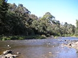
Warrandyte is situated on the southern banks of the Yarra RiverYarra River
The Yarra River, originally Birrarung, is a river in east-central Victoria, Australia. The lower stretches of the river is where the city of Melbourne was established in 1835 and today Greater Melbourne dominates and influences the landscape of its lower reaches...
. The river and hills surrounding the town were once rich in gold, and the ruins of mineshafts and tunnels can be found throughout the Warrandyte State Park
Warrandyte State Park
Warrandyte State Park is a state park, located in Warrandyte, east of Melbourne, Victoria on the banks of the Yarra River and surroundings. The park comprises 586 hectares of remnant bushland in various locations throughout Warrandyte and Wonga Park around Pound Bend, Fourth Hill, Black Flat, Yarra...
amongst other locations. While the central town itself is nestled into a gorge on the river, the suburb covers a reasonably large area of land and can be divided up into the following sections:
Central Warrandyte and the Yarra
Central Warrandyte comprises the main street of Ringwood-Warrandyte Road and Heidelberg-Warrandyte Road (Yarra Street), Pound bend and the southern banks of the Yarra River. This is sometimes referred to as central Warrandyte or the "town", in contrast to the suburbs extending to the south and west.Around Andersons Creek
Andersons Creek flows from neighbouring South Warrandyte and WarranwoodWarranwood, Victoria
Warranwood is a suburb in Melbourne, Victoria, Australia, 27 km north-east from Melbourne's central business district. Its Local Government Area is the City of Maroondah...
into the Yarra just before the beginning of Pound Bend. This area is where several gullies
Gully
A gully is a landform created by running water, eroding sharply into soil, typically on a hillside. Gullies resemble large ditches or small valleys, but are metres to tens of metres in depth and width...
converge and create a geographical hole with Fourth Hill to the east and the hills on the eastern banks of the Mullum Mullum Creek to the west. This becomes evident when driving through Warrandyte on Heidelberg-Warrandyte Road, as the hills guide the road down towards Andersons Creek.
The Eastern banks of the Mullum Mullum Creek
The Eastern banks of the Mullum Mullum Creek were home to vast orchards overflowing from neighbouring East Doncaster and as a result, much of the vegetation has been cleared. Today the area is covered in large residential properties due to local council regulations allowing land to be subdivided into larger sites. Further south from here, Aumann's Orchard can be found, one of the last surviving operational orchards in the area.Vast areas of land around Warrandyte are governed by Parks Victoria or are privately owned such as Longridge Farm. These areas contain dense populations of many different varieties of Eucalyptus
Eucalyptus
Eucalyptus is a diverse genus of flowering trees in the myrtle family, Myrtaceae. Members of the genus dominate the tree flora of Australia...
Trees.
Warrandyte is home to or borders the following rivers and creeks:
- The Yarra RiverYarra RiverThe Yarra River, originally Birrarung, is a river in east-central Victoria, Australia. The lower stretches of the river is where the city of Melbourne was established in 1835 and today Greater Melbourne dominates and influences the landscape of its lower reaches...
- Jumping Creek
- Parson Gully
- Mullum Mullum Creek
- Andersons Creek
Some geographical features that can be found in Warrandyte include:
- Harris Gully
- Beauty Gully
- Fourth Hill
- Pound Bend
- Pound Bend Tunnel
- The Island
- Black Flat
- Whipstick Gully
- Specimen Gully
Ecology
The vegetation in the area was almost entirely cleared during the late 19th century, mostly for agriculture, housing and for mining purposes. The threat of bushfires, several of which destroyed parts of or the entire town, the distance from Melbourne and later, the establishment of the green wedge, halted any large scale development throughout the 20th century. This enabled the native vegetation to regenerate and much of what is seen today was grown back since the late 19th and early 20th centuries.Transportation
Warrandyte is serviced primarily by the private car, however a bus service is run by the Ventura (formerly the National) bus company along the main roads of Ringwood-Warrandyte Road (route number: & ) and Heidelberg-Warrandyte Road (Yarra Street) (route numbers: Occ, Occ, Occ, 155-6 , 906, 364 ). The service interchanges at the bridge (route numbers: 155-6, 159, 201Occ, 304, 305Occ & 308Occ). These two roads service the suburb by car as well as bus. Traffic flowing through Warrandyte usually contains residents traveling from or to East Doncaster, Wonga ParkWonga Park, Victoria
Wonga Park a locality within Greater Melbourne beyond the Melbourne metropolitan area Urban Growth Boundary, 29 km north-east from Melbourne's central business district. Its Local Government Area is the City of Manningham...
, North Warrandyte
North Warrandyte, Victoria
North Warrandyte is a suburb in Melbourne, Victoria, Australia, 25 km north-east from Melbourne's central business district. Its Local Government Area is the Shire of Nillumbik...
and Park Orchards
Park Orchards, Victoria
Park Orchards is a suburb in Melbourne, Victoria, Australia, 23 km north-east from Melbourne's central business district. Its Local Government Area is the City of Manningham. At the 2006 Census, Park Orchards had a population of 3590....
, however, due to Warrandyte's geographical position, it can at times be used to travel to and from other suburbs.
Peak hour traffic always flows to and from west and south of Warrandyte along its main roads, this traffic is either trying to get out of surrounding suburbs or to the Eastern Freeway.
Major local roads in Warrandyte include:
- Reynolds Road
- Tindals Road
- Beauty Gully Road
- Harris Gully Road
- Gold Memorial Road
- Pound Road
- Webb Street
- Jumping Creek Road
- Yarra Street
Community
Country Fire Authority
Country Fire Authority, or CFA, is the name of the fire service that provides firefighting and other emergency services to all of the country areas and regional townships within the state of Victoria, Australia, as well as large portions of the outer suburban areas and growth corridors of Melbourne...
. A variety of live music stages are set up, with stages specifically catering for youth bands from the community. The festival parade is a feature of the festival, with bands, community orientated groups and schools all partaking in a morning march through the town.
Warrandyte contains a general post office, tennis courts, a community centre, an RSL, several Bed and Breakfast
Bed and breakfast
A bed and breakfast is a small lodging establishment that offers overnight accommodation and breakfast, but usually does not offer other meals. Since the 1980s, the meaning of the term has also extended to include accommodations that are also known as "self-catering" establishments...
s, restaurants, a police station, a CFA Fire Station, two kindergartens, two recreational ovals (AFL Football and Cricket), Warrandyte Community Church, Uniting and Anglican places of worship, Andersons Creek Cemetery and a Scout hall
Scouting in Victoria
Scouting and Guiding in Victoria, a State of Australia, is predominantly represented by the state branch of Scouts Australia and Girl Guides Victoria, a member of Girl Guides Australia.-Scouts Australia - Victorian Branch:...
, canoe launching ramps, a skatepark, nurseries and tearooms and the Crystal Brook Holiday Centre.
Educational Facilities in Warrandyte:
- Warrandyte High SchoolWarrandyte High SchoolWarrandyte High School is a high school in Warrandyte, Victoria, Australia. Established as only a few portable classrooms in 1978, it now comprises two main buildings and many semi-permanent portables set amongst many types of eucalyptus, native wildlife and other native vegetation, on a hillside...
- Andersons Creek Primary School
- Warrandyte Primary School
Shopping Strips & Centres in Warrandyte:
- Goldfields Plaza
- Street Shops either side of the Main Roads around the Bridge
Parklands and recreation
Many people who live outside of Warrandyte travel to the suburb to partake in different recreational activities, as well as its residents. These include walking, bike riding, mountain biking, tennis, basketball, football (AFL), cricket, swimming in the Yarra RiverYarra River
The Yarra River, originally Birrarung, is a river in east-central Victoria, Australia. The lower stretches of the river is where the city of Melbourne was established in 1835 and today Greater Melbourne dominates and influences the landscape of its lower reaches...
, canoeing, kayaking, skateboarding and bushwalking among many others.
Parks, Gardens and Reserves in Warrandyte:
- Warrandyte State ParkWarrandyte State ParkWarrandyte State Park is a state park, located in Warrandyte, east of Melbourne, Victoria on the banks of the Yarra River and surroundings. The park comprises 586 hectares of remnant bushland in various locations throughout Warrandyte and Wonga Park around Pound Bend, Fourth Hill, Black Flat, Yarra...
(including Pound Bend, Fourth Hill, Black Flat, Mount Lofty and other areas) - Pound BendGeography of the Yarra RiverThe Yarra River is a river in East-Central Victoria, Australia that flows through the city of Melbourne. This article contains explanations and lists of the river's tributaries and other geographic features...
Reserve - Stiggants Reserve
- Warrandyte Reserve/Taroona Reserve (Home to the Warrandyte Cricket Club, which is the 4th oldest in Victoria formed in 1855), Warrandyte The Bloods Football Club competing in the Eastern Football LeagueEastern Football League (Australia)The Eastern Football League is an Australian rules football League, based in the eastern suburbs of metropolitan Melbourne....
and Junior Football Clubs and Warrandyte Netball Club) - Longridge Farm
- Alexander Reserve
- Currawong Bush ParkCurrawong Bush ParkCurrawong Bush Park is an important riparian bushland park, located in the outer eastern suburbs of Melbourne on the borders of Doncaster East, Warrandyte and Donvale, on the eastern bank of the Mullum Mullum Creek...
(Environment Centre and Wildlife Enclosure) - Wildflower Reserve
- Andersons Creek Streamside Reserve
See also
- City of Doncaster and Templestowe - the former local government area of which Warrandyte was a part
- Electoral district of WarrandyteElectoral district of WarrandyteThe Electoral district of Warrandyte is an electoral district of the Victorian Legislative Assembly. It is an outer metropolitan electorate and contains Warrandyte, Warranwood as well as parts of Croydon and Ringwood....
- List of Melbourne suburbs
- Victorian gold rushVictorian gold rushThe Victorian gold rush was a period in the history of Victoria, Australia approximately between 1851 and the late 1860s. In 10 years the Australian population nearly tripled.- Overview :During this era Victoria dominated the world's gold output...
- Manningham Municipal Council Offices. See - City of ManninghamCity of ManninghamThe City of Manningham is a Local Government Area in Victoria, Australia. It is located in the northeastern suburbs of Melbourne. The total population is 118,544 , divided up into 10 suburbs, the largest being Doncaster and Templestowe, over an area of 113 square kilometres.The district spans a...