

Geography of the Yarra River
Encyclopedia
Yarra River
The Yarra River, originally Birrarung, is a river in east-central Victoria, Australia. The lower stretches of the river is where the city of Melbourne was established in 1835 and today Greater Melbourne dominates and influences the landscape of its lower reaches...
is a river
River
A river is a natural watercourse, usually freshwater, flowing towards an ocean, a lake, a sea, or another river. In a few cases, a river simply flows into the ground or dries up completely before reaching another body of water. Small rivers may also be called by several other names, including...
in East-Central Victoria
Victoria (Australia)
Victoria is the second most populous state in Australia. Geographically the smallest mainland state, Victoria is bordered by New South Wales, South Australia, and Tasmania on Boundary Islet to the north, west and south respectively....
, Australia
Australia
Australia , officially the Commonwealth of Australia, is a country in the Southern Hemisphere comprising the mainland of the Australian continent, the island of Tasmania, and numerous smaller islands in the Indian and Pacific Oceans. It is the world's sixth-largest country by total area...
that flows through the city of Melbourne
Melbourne
Melbourne is the capital and most populous city in the state of Victoria, and the second most populous city in Australia. The Melbourne City Centre is the hub of the greater metropolitan area and the Census statistical division—of which "Melbourne" is the common name. As of June 2009, the greater...
. This article contains explanations and lists of the river's tributaries and other geographic feature
Geographic feature
Geographical features are the components of the Earth. There are two types of geographical features, namely natural geographical features and artificial geographical features. Natural geographical features include but are not limited to landforms and ecosystems...
s. The river flows atop layers of silt that built up within an ancient river valley around 10,000-15,000 years ago.
The river's major tributaries are the Plenty River
Plenty River
The Plenty River is a tributary of the Yarra River in Victoria, Australia. Originating in the forested slopes of Mount Disappointment, the Plenty River is the source of Melbourne's first major water supply in the form of the Yan Yean Reservoir....
, Merri Creek
Merri Creek
The Merri Creek is a waterway in southern parts of Victoria, Australia which flows through the northern suburbs of Melbourne. It begins in Wallan north of Melbourne and flows south for 70km until it joins the Yarra River at Dights Falls...
, Darebin Creek
Darebin Creek
Darebin Creek is a creek that runs through the northern suburbs of Melbourne, Victoria, Australia. It is the main watercourse of the Darebin Valley and a major tributary of the Yarra River...
, Gardiners Creek
Gardiners Creek
Gardiners Creek, originally known as Kooyongkoot Creek, is a waterway in the eastern suburbs of Melbourne, and part of the Yarra River catchment....
, Mullum Mullum Creek and the Moonee Ponds Creek
Moonee Ponds Creek
The Moonee Ponds Creek is a creek and major tributary of the Yarra River running through urban Melbourne, Victoria, Australia from northern to inner suburbs...
. It hosts a wide range of geographic feature
Geographic feature
Geographical features are the components of the Earth. There are two types of geographical features, namely natural geographical features and artificial geographical features. Natural geographical features include but are not limited to landforms and ecosystems...
s including; bends, rapid
Rapid
A rapid is a section of a river where the river bed has a relatively steep gradient causing an increase in water velocity and turbulence. A rapid is a hydrological feature between a run and a cascade. A rapid is characterised by the river becoming shallower and having some rocks exposed above the...
s, lake
Lake
A lake is a body of relatively still fresh or salt water of considerable size, localized in a basin, that is surrounded by land. Lakes are inland and not part of the ocean and therefore are distinct from lagoons, and are larger and deeper than ponds. Lakes can be contrasted with rivers or streams,...
s, island
Island
An island or isle is any piece of sub-continental land that is surrounded by water. Very small islands such as emergent land features on atolls can be called islets, cays or keys. An island in a river or lake may be called an eyot , or holm...
s, floodplain
Floodplain
A floodplain, or flood plain, is a flat or nearly flat land adjacent a stream or river that stretches from the banks of its channel to the base of the enclosing valley walls and experiences flooding during periods of high discharge...
s, billabong
Billabong
Billabong is an Australian English word meaning a small lake, specifically an oxbow lake, a section of still water adjacent to a river, cut off by a change in the watercourse. Billabongs are usually formed when the path of a creek or river changes, leaving the former branch with a dead end...
s, wetland
Wetland
A wetland is an area of land whose soil is saturated with water either permanently or seasonally. Wetlands are categorised by their characteristic vegetation, which is adapted to these unique soil conditions....
s, etc. Most features have been named after translated Woiwurrung
Woiwurrung
Woiwurrung is an Indigenous Australian language spoken by some of the Kulin Nation clans, the Wurundjeri people, of Central Victoria, from Mount Baw Baw in the east to Mount Macedon, Sunbury and Gisborne in the west.The Woiwurrung clans inhabited the Yarra River, called Birrarung in Woiwurrung,...
phrases or have European, particularly British
Great Britain
Great Britain or Britain is an island situated to the northwest of Continental Europe. It is the ninth largest island in the world, and the largest European island, as well as the largest of the British Isles...
, origins.
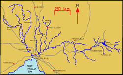
Tributaries
The Yarra River has about 50 named tributaries in total; 6 rivers, 42 creeks and 2 gullies. At its most easterly point, it is fed by many small unnamed creeks and streams that begin in the Yarra Ranges within the Yarra Ranges National ParkYarra Ranges National Park
Yarra Ranges is a national park in Victoria, Australia, 92 km east of Melbourne. It covers the headwaters of the Yarra River in the ranges themselves and several water catchments for Melbourne's domestic water supply....
, which are sometimes fed by snowfalls. Below is a list of its tributaries (from downstream to upstream):
- Stony CreekStony Creek (Melbourne)Stony Creek is located in the western suburbs of Melbourne, Victoria, Australia. It runs through the suburbs of St Albans, Albion, Sunshine, Braybrook, Tottenham, Brooklyn, Kingsville and Yarraville....
- Maribyrnong RiverMaribyrnong riverThe Maribyrnong River rises about 50 km north of Melbourne, Victoria , near Mount Macedon. It flows generally southward and combines with the Yarra River to flow into Port Phillip....
37°45′19"S 144°50′57"E - Moonee Ponds CreekMoonee Ponds CreekThe Moonee Ponds Creek is a creek and major tributary of the Yarra River running through urban Melbourne, Victoria, Australia from northern to inner suburbs...
37°45′39"S 144°55′59"E - Kooyong Koot Creek (Gardiners Creek)Gardiners CreekGardiners Creek, originally known as Kooyongkoot Creek, is a waterway in the eastern suburbs of Melbourne, and part of the Yarra River catchment....
37°52′18"S 145°05′23"E - Merri CreekMerri CreekThe Merri Creek is a waterway in southern parts of Victoria, Australia which flows through the northern suburbs of Melbourne. It begins in Wallan north of Melbourne and flows south for 70km until it joins the Yarra River at Dights Falls...
37°40′01"S 144°58′35"E - Darebin CreekDarebin CreekDarebin Creek is a creek that runs through the northern suburbs of Melbourne, Victoria, Australia. It is the main watercourse of the Darebin Valley and a major tributary of the Yarra River...
37°39′32"S 145°02′08"E - Glass Creek
- Koonung Koonung CreekKoonung CreekKoonung Creek is a small tributary of the Yarra River in Melbourne's east. The creek originates in Nunawading near Springvale Road, and flows to join the Yarra at the border between Ivanhoe East, Bulleen and Balwyn North. The place the two waterways meet forms the borders between these suburbs...
37°47′11"S 145°06′16"E - Salt Creek 37°44′27"S 145°04′19"E
- Banyule Creek
- Plenty RiverPlenty RiverThe Plenty River is a tributary of the Yarra River in Victoria, Australia. Originating in the forested slopes of Mount Disappointment, the Plenty River is the source of Melbourne's first major water supply in the form of the Yan Yean Reservoir....
37°36′46"S 145°06′20"E - Ruffey Creek 37°46′08"S 145°08′22"E
- Kestrel Creek
- Diamond Creek 37°37′42"S 145°12′38"E
- Mullum Mullum Creek 37°46′25"S 145°11′21"E
- Stony Creek 37°42′58"S 145°12′30"E
- Andersons CreekAndersons CreekAndersons Creek is a creek in Warrandyte and Park Orchards, east of Melbourne, Victoria, Australia. It is a tributary of the Yarra River. For tens of thousands of years it was used as a food and tool source sustainably by the Wurundjeri people, Indigenous Australians of the Kulin nation, who spoke...
37°44′59"S 145°12′38"E - Parson Gully
- Jumping Creek 37°45′42"S 145°15′27"E
- Pigeon Bank Gully 37°42′44"S 145°14′26"E
- Watsons Creek 37°39′08"S 145°18′02"E
- Brushy Creek 37°45′41"S 145°17′45"E
- Olinda CreekOlinda CreekOlinda Creek is a major tributary of the Yarra River in Victoria, Australia. Its origins are in the Dandenong Ranges, and it is notable for passing through the settlement of Lilydale before joining with the Yarra near Coldstream.....
37°45′57"S 145°21′17"E - Steels Creek 37°37′15"S 145°22′31"E
- Pauls Creek 37°38′26"S 145°26′02"E
- Watts River 37°37′29"S 145°39′34"E
- Badger Creek 37°41′14"S 145°35′41"E
- Woori Yallock Creek 37°43′52"S 145°29′53"E
- Ure Creek 37°45′18"S 145°32′50"E
- Hoddles Creek 37°47′35"S 145°34′54"E
- Don River 37°45′20"S 145°35′13"E
- Little Yarra RiverLittle Yarra RiverThe Little Yarra River is a tributary of the Yarra River. It flows from native forests in the Yarra Ranges around Powelltown, passing through rural areas to join the Yarra River below Yarra Junction.-References:...
37°50′16"S 145°40′46"E - Don Creek 37°45′47"S 145°36′21"E
- Platts Creek 37°45′15"S 145°37′15"E
- Frenchman Creek 37°44′23"S 145°37′41"E
- Yankee Jim Creek 37°46′21"S 145°39′21"E
- Dee River 37°44′59"S 145°38′41"E
- Scotchman Creek
- Four Mile Creek 37°46′03"S 145°42′25"E
- Pheasant Creek 37°45′31"S 145°42′52"E
- Starling Creek 37°45′56"S 145°43′36"E
- Big Pats Creek 37°48′22"S 145°45′06"E
- Dead Horse Creek 37°43′39"S 145°45′31"E
- Cement Creek 37°42′50"S 145°44′31"E
- Braham Creek 37°45′11"S 145°47′32"E
- McDonald Creek 37°44′59"S 145°47′49"E
- Crooked Creek
- Starvation Creek 37°45′39"S 145°51′16"E
- Alderman Creek 37°43′37"S 145°56′45"E
Geographical Features
Billabong
Billabong is an Australian English word meaning a small lake, specifically an oxbow lake, a section of still water adjacent to a river, cut off by a change in the watercourse. Billabongs are usually formed when the path of a creek or river changes, leaving the former branch with a dead end...
s, of which there are over 100, particularly in the floodplains near Yering, Yarra Glen and Coldstream
Coldstream, Victoria
Coldstream is a locality and township within Greater Melbourne beyond the Melbourne metropolitan area Urban Growth Boundary, 36 km north-east from Melbourne's central business district. Its Local Government Area is the Shire of Yarra Ranges...
. Being a considerably thin river for almost its entire length, there are very few islands or lakes. In the middle reaches there are a few rapids of easy to moderate difficulty, however these are sparsly distributed. Below is a list of the river's geographical features, including tributaries (shown in bold) and man-made features or townships (shown in italics), for bearings (from downstream to upstream):
- Entrance to Yarra River in Hobsons BayHobsons BayHobsons Bay is a bay in Port Phillip, Victoria, Australia....
- West Gate BridgeWest Gate BridgeThe West Gate Bridge is a steel box girder cable-stayed bridge in Melbourne, Victoria, Australia. It spans the Yarra River, just north of its mouth into Port Phillip, and is a vital link between the inner city and Melbourne's western suburbs with the industrial suburbs in the west and with the city...
- Stony CreekStony Creek (Melbourne)Stony Creek is located in the western suburbs of Melbourne, Victoria, Australia. It runs through the suburbs of St Albans, Albion, Sunshine, Braybrook, Tottenham, Brooklyn, Kingsville and Yarraville....
- Maribyrnong RiverMaribyrnong riverThe Maribyrnong River rises about 50 km north of Melbourne, Victoria , near Mount Macedon. It flows generally southward and combines with the Yarra River to flow into Port Phillip....
- Coode Island (created in 1880s)
- Fishermans Bend (created in 1880s)
- Moonee Ponds CreekMoonee Ponds CreekThe Moonee Ponds Creek is a creek and major tributary of the Yarra River running through urban Melbourne, Victoria, Australia from northern to inner suburbs...
- Victoria HarbourVictoria HarbourVictoria Harbour is a natural landform harbour situated between Hong Kong Island and the Kowloon Peninsula in Hong Kong. The harbour's deep, sheltered waters and strategic location on the South China Sea were instrumental in Hong Kong's establishment as a British colony and its subsequent...
(created in 1892) - Batman's HillBatman's HillBatman's Hill in Melbourne, Australia was named for the Vandemonian adventurer and grazier John Batman. Now removed, the 18 metre high hill was located to the south of today's Collins Street and Southern Cross railway station, and is the site of a steel marker the same height as the original...
(levelled in mid-19th century) - Turning Basin
- Melbourne CBD
- Princes BridgePrinces BridgePrinces Bridge may refer to:* Princes Bridge, in Melbourne over the Yarra River* Princes Bridge railway station, Melbourne* Princes Bridge, over the Barwon River in Victoria...
- Birrarung Marr
- Ornamental Lake
- Punt Hill
- Herring IslandHerring Island (Victoria)Herring Island is a small island located in Melbourne's Yarra River at South Yarra, approximately 3 km from the city. Originally a quarry, it was leased by the scouts in the 1950s and 1960s and is currently managed by Parks Victoria and used as a sculpture park...
- Burnley Harbour & Wetlands
- Gardiners CreekGardiners CreekGardiners Creek, originally known as Kooyongkoot Creek, is a waterway in the eastern suburbs of Melbourne, and part of the Yarra River catchment....
- Burnley Bend
- HawthornHawthorn, VictoriaHawthorn is a suburb in Melbourne, Victoria, Australia, east from Melbourne's central business district. Its Local Government Area is the City of Boroondara...
- Yarra Bend (Ends)
- Dights FallsDights FallsDights Falls is located in Melbourne, Victoria just downstream of the junction of the Yarra River with Merri Creek. At this point the river narrows and is constricted between 800,000 year old volcanic, basaltic lava flow and a much older steep, silurian, sedimentary spur...
- Merri CreekMerri CreekThe Merri Creek is a waterway in southern parts of Victoria, Australia which flows through the northern suburbs of Melbourne. It begins in Wallan north of Melbourne and flows south for 70km until it joins the Yarra River at Dights Falls...
- Galatea Point
- Studley Park Boathouse
- Flying Fox Lookout
- Fairfield Boathouse
- Yarra Bend (Begins)
- Kew Billabong
- Darebin CreekDarebin CreekDarebin Creek is a creek that runs through the northern suburbs of Melbourne, Victoria, Australia. It is the main watercourse of the Darebin Valley and a major tributary of the Yarra River...
- Glass Creek
- Yarra Flats (Ends)
- Koonung CreekKoonung CreekKoonung Creek is a small tributary of the Yarra River in Melbourne's east. The creek originates in Nunawading near Springvale Road, and flows to join the Yarra at the border between Ivanhoe East, Bulleen and Balwyn North. The place the two waterways meet forms the borders between these suburbs...
- Bolin Bolin Billabong (cut off in 1100)
- Annulus Billabong
- Salt Creek
- Sills Bend
- HeidelbergHeidelberg-Early history:Between 600,000 and 200,000 years ago, "Heidelberg Man" died at nearby Mauer. His jaw bone was discovered in 1907; with scientific dating, his remains were determined to be the earliest evidence of human life in Europe. In the 5th century BC, a Celtic fortress of refuge and place of...
- Yarra Flats (Begins)
- Banyule Creek
- Banyule Flats & Billabongs
- Plenty RiverPlenty RiverThe Plenty River is a tributary of the Yarra River in Victoria, Australia. Originating in the forested slopes of Mount Disappointment, the Plenty River is the source of Melbourne's first major water supply in the form of the Yan Yean Reservoir....
- Templestowe
- Ruffey Creek
- Kestrel Creek
- Westerfolds Rapids
- Fitzsimons Lane Bridge
- Diamond Creek
- Sweeneys Flats
- Mullum Mullum Creek
- Tikalara
- Pound Bend (Ends)
- Bobs Wetlands
- Pound Bend TunnelPound Bend TunnelThe Pound Bend Tunnel, or the Evelyn Tunnel, is a diversion tunnel on the Yarra River at Warrandyte, Victoria, Australia, approximately 24 km north-east of Melbourne...
- Stony Creek
- Pound Bend (Begins)
- Andersons CreekAndersons CreekAndersons Creek is a creek in Warrandyte and Park Orchards, east of Melbourne, Victoria, Australia. It is a tributary of the Yarra River. For tens of thousands of years it was used as a food and tool source sustainably by the Wurundjeri people, Indigenous Australians of the Kulin nation, who spoke...
- Fourth Hill
- Whipstick Gully
- Warrandyte
- Scotchmans Hill
- The IslandThe Island, Thompson Bend, WarrandyteThe Island is located at Thompson Bend on the Yarra River at Warrandyte, Victoria, Australia, approximately north-east of Melbourne. It was created by gold miners in 1859-60, during the Victorian gold rush...
- Parson Gully
- Black Flat
- Jumping Creek
- Blue Tongue Bend
- Warrandyte Gorge
- Pigeon Bank Gully
- Kangaroo Ground Rapids
- Watsons Creek
- Bend of Isles
- Moniques Island
- Brushy Creek
- Mount Lofty
- Bob's Rock
- Canoe Slalom Rapids
- Christmas Hills Rapids
- Yering Gorge
- Yering Billabongs
- Olinda CreekOlinda CreekOlinda Creek is a major tributary of the Yarra River in Victoria, Australia. Its origins are in the Dandenong Ranges, and it is notable for passing through the settlement of Lilydale before joining with the Yarra near Coldstream.....
- Yarra Glen
- Yarra Flats Billabongs
- Steels Creek
- Coldstream Flats & Billabongs
- Pauls Creek
- Healesville
- Watts RiverWatts RiverThe Watts River is a tributary of the Yarra River. It rises on the southern slopes of the Great Dividing Range, north east of Healesville, Victoria, Australia and joins the Yarra River near Healesville...
- Badger Creek
- Warramate Hills
- Woori Yallock CreekWoori Yallock CreekWoori Yallock Creek is a tributary of the Yarra River. It rises on the eastern slopes of the Dandenong Ranges, then flows north to join the Yarra River near Woori Yallock....
- Woori Yallock Flats & Billabong
- Ure Creek
- Launching Place
- Hoddles Creek
- Don River
- Little Yarra RiverLittle Yarra RiverThe Little Yarra River is a tributary of the Yarra River. It flows from native forests in the Yarra Ranges around Powelltown, passing through rural areas to join the Yarra River below Yarra Junction.-References:...
- Don Creek
- Yarra Junction
- Don Creek
- Platts Creek
- Frenchman Creek
- Yankee Jim Creek
- Dee River
- Scotchmans Creek
- WarburtonWarburton, VictoriaWarburton is a town in Victoria, Australia, 72 km east from Melbourne's central business district. Its Local Government Area is the Shire of Yarra Ranges. At the 2006 Census, Warburton had a population of 2288....
- Four Mile Creek
- Pheasant Creek
- Starling Creek
- Big Pats Creek
- Dead Horse Creek
- Cement Creek
- Braham Creek
- McDonald Creek
- Crooked Creek
- Starvation Creek
- Little Peninsula TunnelLittle Peninsula TunnelThe Little Peninsula Tunnel is a small river diversion tunnel on the upper Yarra River near McMahons Creek, around 80 km East of Melbourne, Victoria, Australia...
- Big Peninsula TunnelBig Peninsula TunnelThe Big Peninsula Tunnel is a small river diversion tunnel on the upper Yarra River near McMahons Creek, around 80 km East of Melbourne, Victoria, Australia. The tunnel was dug in 1864, during the Victorian gold rush, by alluvial gold miners to provide access to the bed of the Yarra River...
- McMahons Creek
- Upper Yarra Dam
- Upper Yarra Reservoir (created in 1957)
- Alderman Creek