
Wasatch-Cache National Forest
Encyclopedia
Uinta-Wasatch-Cache National Forest is a United States National Forest
located primarily in northern Utah
(81.23%), with smaller parts extending into southeastern Idaho
(16.42%) and southwestern Wyoming
(2.35%). The name is from the Ute
word Wasatch for a low place in high mountains, and the French word Cache meaning to hide. It was originally a term that referred to fur trappers
, the first Europeans to visit the land. The Cache and Wasatch forest boundaries include 1607177 acres (6,504 km²) of land.
The Wasatch-Cache was headquartered in downtown Salt Lake City, Utah
until August 2007 when its management was combined with the Uinta National Forest
and is currently being managed as the Uinta-Wasatch-Cache National Forest. The merged forest is based out of both Salt Lake City, Utah
and Provo
The Kamas Ranger District will be merged with the Uinta National Forest's Heber Ranger District in Heber City. With the newly included Uinta National Forest
the forest will expand to 2487896 acres (10,068.2 km²).
Cache National Forest is located in northern Utah and southern Idaho. It has a land area of 701,453 acre
s (1,096 sq mi, or 2,838.7 km2). In descending order of land area it is located in parts of Cache, Bear Lake
, Franklin
, Weber
, Rich
, Box Elder
, Caribou
, and Morgan
counties. (Bear Lake, Franklin, and Caribou counties are in Idaho, with the rest being in Utah.) There are local ranger
district offices located in Logan
and Ogden
.
Wasatch National Forest is located in northeastern Utah and southwestern Wyoming. It has a land area of 905,724 acres (1,415.2 sq mi, or 3,365.3 km2). In descending order of land area it is located in parts of Summit
, Tooele
, Salt Lake
, Davis
, Uinta
, Duchesne
, Wasatch
, Morgan
, Utah
, Weber
, and Juab
counties. (Uinta County is in Wyoming, with the rest being in Utah.) There are local ranger district offices located in Evanston
and Mountain View in Wyoming, and in Kamas
, and Salt Lake City
in Utah.
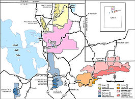 There are seven designated wilderness areas in the Wasatch-Cache National Forest, totalling approximately 309000 acres (1,250.5 km²) and comprising approximately 25% of the Forest's total acreage.
Logan District
Kamas, Evanston and Mountain View Districts
Salt Lake District

United States National Forest
National Forest is a classification of federal lands in the United States.National Forests are largely forest and woodland areas owned by the federal government and managed by the United States Forest Service, part of the United States Department of Agriculture. Land management of these areas...
located primarily in northern Utah
Utah
Utah is a state in the Western United States. It was the 45th state to join the Union, on January 4, 1896. Approximately 80% of Utah's 2,763,885 people live along the Wasatch Front, centering on Salt Lake City. This leaves vast expanses of the state nearly uninhabited, making the population the...
(81.23%), with smaller parts extending into southeastern Idaho
Idaho
Idaho is a state in the Rocky Mountain area of the United States. The state's largest city and capital is Boise. Residents are called "Idahoans". Idaho was admitted to the Union on July 3, 1890, as the 43rd state....
(16.42%) and southwestern Wyoming
Wyoming
Wyoming is a state in the mountain region of the Western United States. The western two thirds of the state is covered mostly with the mountain ranges and rangelands in the foothills of the Eastern Rocky Mountains, while the eastern third of the state is high elevation prairie known as the High...
(2.35%). The name is from the Ute
Ute Tribe
The Ute are an American Indian people now living primarily in Utah and Colorado. There are three Ute tribal reservations: Uintah-Ouray in northeastern Utah ; Southern Ute in Colorado ; and Ute Mountain which primarily lies in Colorado, but extends to Utah and New Mexico . The name of the state of...
word Wasatch for a low place in high mountains, and the French word Cache meaning to hide. It was originally a term that referred to fur trappers
Fur trade
The fur trade is a worldwide industry dealing in the acquisition and sale of animal fur. Since the establishment of world market for in the early modern period furs of boreal, polar and cold temperate mammalian animals have been the most valued...
, the first Europeans to visit the land. The Cache and Wasatch forest boundaries include 1607177 acres (6,504 km²) of land.
The Wasatch-Cache was headquartered in downtown Salt Lake City, Utah
Salt Lake City, Utah
Salt Lake City is the capital and the most populous city of the U.S. state of Utah. The name of the city is often shortened to Salt Lake or SLC. With a population of 186,440 as of the 2010 Census, the city lies in the Salt Lake City metropolitan area, which has a total population of 1,124,197...
until August 2007 when its management was combined with the Uinta National Forest
Uinta National Forest
Uinta National Forest is a national forest located in north central Utah, USA. It was originally part of the Uinta Forest Reserve, created by Grover Cleveland on February 2, 1897. The name is derived from the Ute word Yoov-we-teuh which means pine forest...
and is currently being managed as the Uinta-Wasatch-Cache National Forest. The merged forest is based out of both Salt Lake City, Utah
Salt Lake City, Utah
Salt Lake City is the capital and the most populous city of the U.S. state of Utah. The name of the city is often shortened to Salt Lake or SLC. With a population of 186,440 as of the 2010 Census, the city lies in the Salt Lake City metropolitan area, which has a total population of 1,124,197...
and Provo
Provo, Utah
Provo is the third largest city in the U.S. state of Utah, located about south of Salt Lake City along the Wasatch Front. Provo is the county seat of Utah County and lies between the cities of Orem to the north and Springville to the south...
The Kamas Ranger District will be merged with the Uinta National Forest's Heber Ranger District in Heber City. With the newly included Uinta National Forest
Uinta National Forest
Uinta National Forest is a national forest located in north central Utah, USA. It was originally part of the Uinta Forest Reserve, created by Grover Cleveland on February 2, 1897. The name is derived from the Ute word Yoov-we-teuh which means pine forest...
the forest will expand to 2487896 acres (10,068.2 km²).
Cache National Forest is located in northern Utah and southern Idaho. It has a land area of 701,453 acre
Acre
The acre is a unit of area in a number of different systems, including the imperial and U.S. customary systems. The most commonly used acres today are the international acre and, in the United States, the survey acre. The most common use of the acre is to measure tracts of land.The acre is related...
s (1,096 sq mi, or 2,838.7 km2). In descending order of land area it is located in parts of Cache, Bear Lake
Bear Lake County, Idaho
Bear Lake County is a county located in the U.S. state of Idaho. As of the 2000 Census the county had a population of 6,411 . The county seat is Paris, and Montpelier is the largest city....
, Franklin
Franklin County, Idaho
Franklin County is a county located in the U.S. state of Idaho. As of the 2000 Census the county had a population of 11,329 . The county seat and largest city is Preston. Franklin County is part of the Logan, Utah-Idaho Metropolitan Statistical Area.Established in 1913, Franklin County was named...
, Weber
Weber County, Utah
Weber County is a county located in the U.S. state of Utah, occupying a stretch of the Wasatch Front, part of the eastern shores of Great Salt Lake, and much of the rugged Wasatch Mountains. As of the 2000 census, the population was 196,533, an increase of 24.1% over its population in 1990. By...
, Rich
Rich County, Utah
Rich County is a county located in the U.S. state of Utah. The southern half of Bear Lake and the Bear Lake Valley lie on the northern edge of the county. The Bear River Valley lies in most of the eastern portion of the county. The elevation of these valleys is close to , and the rest of the county...
, Box Elder
Box Elder County, Utah
Box Elder County is a county located in the U.S. state of Utah. It lies on the north end of the Great Salt Lake, covering a large area north to the Idaho border and west to the Nevada border. Included in this area are large tracts of barren desert, contrasted by high, forested mountains. The...
, Caribou
Caribou County, Idaho
Caribou County is a county located in the U.S. state of Idaho. As of the 2010 Census the county had a population of 6,963. The county seat and largest city is Soda Springs, followed by Grace and Bancroft.- History :...
, and Morgan
Morgan County, Utah
Morgan County is a county located in the U.S. state of Utah. As of 2010 the population was 9,469. It was named for Jedediah Morgan Grant, father of Heber J. Grant, who served as president of the Church of Jesus Christ of Latter-day Saints...
counties. (Bear Lake, Franklin, and Caribou counties are in Idaho, with the rest being in Utah.) There are local ranger
National Park Ranger
National Park Service Rangers are among the uniformed employees charged with protecting and preserving areas set aside in the National Park System by the United States Congress and/or the President of the United States...
district offices located in Logan
Logan, Utah
-Layout of the City:Logan's city grid originates from its Main and Center Street block, with Main Street running north and south, and Center east and west. Each block north, east, south, or west of the origin accumulates in additions of 100 , though some streets have non-numeric names...
and Ogden
Ogden, Utah
Ogden is a city in Weber County, Utah, United States. Ogden serves as the county seat of Weber County. The population was 82,825 according to the 2010 Census. The city served as a major railway hub through much of its history, and still handles a great deal of freight rail traffic which makes it a...
.
Wasatch National Forest is located in northeastern Utah and southwestern Wyoming. It has a land area of 905,724 acres (1,415.2 sq mi, or 3,365.3 km2). In descending order of land area it is located in parts of Summit
Summit County, Utah
Summit County is a county located in the U.S. state of Utah, occupying a rugged and mountainous area. In 2010 its population was 36,324. It is part of the Salt Lake City Metropolitan Statistical Area as well as the Salt Lake City–Ogden–Clearfield Combined Statistical Area. The county is...
, Tooele
Tooele County, Utah
Tooele County is a county located in the U.S. state of Utah. As of 2000, the population was 40,735 and by 2005 was estimated at 51,311. Its county seat and largest city is Tooele....
, Salt Lake
Salt Lake County, Utah
Salt Lake County is a county located in the U.S. state of Utah. It had a population of 1,029,655 at the 2010 census. Its county seat and largest city is Salt Lake City, the state capital. It occupies Salt Lake Valley, as well as parts of the surrounding mountains, the Oquirrh Mountains to the west...
, Davis
Davis County, Utah
Davis County is a county located in the U.S. state of Utah. As of 2010 the population was 306,479, a 28.2% increase over the 2000 figure of 238,994. It was named for Daniel C. Davis, captain in the Mormon Battalion. The county is part of the Ogden–Clearfield Metropolitan Statistical Area as...
, Uinta
Uinta County, Wyoming
-Demographics:As of the census of 2000, there were 19,742 people, 6,823 households, and 5,144 families residing in the county. The population density was 10 people per square mile . There were 8,011 housing units at an average density of 4 per square mile...
, Duchesne
Duchesne County, Utah
Duchesne County is a county located in the U.S. state of Utah. As of 2010 the population was 18,607, a 29.5% increase over the 2000 figure of 14,371. Its county seat is Duchesne and the largest city is Roosevelt.-Geography:...
, Wasatch
Wasatch County, Utah
Wasatch County is a county located in the U.S. state of Utah. It was named for a Ute Indian word meaning mountain pass or low place in the high mountains. Its county seat and largest city is Heber City.The county is governed by a county council with an appointed county manager.Wasatch County is...
, Morgan
Morgan County, Utah
Morgan County is a county located in the U.S. state of Utah. As of 2010 the population was 9,469. It was named for Jedediah Morgan Grant, father of Heber J. Grant, who served as president of the Church of Jesus Christ of Latter-day Saints...
, Utah
Utah County, Utah
Utah County is a county located in the U.S. state of Utah. As of 2000, the population was 368,536 and by 2008 was estimated at 530,837. It was named for the Spanish name for the Ute Indians. The county seat and largest city is Provo...
, Weber
Weber County, Utah
Weber County is a county located in the U.S. state of Utah, occupying a stretch of the Wasatch Front, part of the eastern shores of Great Salt Lake, and much of the rugged Wasatch Mountains. As of the 2000 census, the population was 196,533, an increase of 24.1% over its population in 1990. By...
, and Juab
Juab County, Utah
Juab County is a county located in the U.S. state of Utah. As of 2000 the population was 8,238, and by 2005 had been estimated at 9,113. It was named from an Indian word meaning thirsty valley, or possibly only valley. Its county seat and largest city is Nephi.Juab County is part of the...
counties. (Uinta County is in Wyoming, with the rest being in Utah.) There are local ranger district offices located in Evanston
Evanston, Wyoming
Evanston is a city in Uinta County, Wyoming, United States. The population was 12,359 at the 2010 census. It is the county seat of Uinta County.-Geography:Evanston is located at...
and Mountain View in Wyoming, and in Kamas
Kamas, Utah
Kamas is a city in Summit County, Utah, United States. It is part of the Salt Lake City, Utah Metropolitan Statistical Area. The population was 1,274 at the 2000 census....
, and Salt Lake City
Salt Lake City, Utah
Salt Lake City is the capital and the most populous city of the U.S. state of Utah. The name of the city is often shortened to Salt Lake or SLC. With a population of 186,440 as of the 2010 Census, the city lies in the Salt Lake City metropolitan area, which has a total population of 1,124,197...
in Utah.
Wilderness areas
Logan District
- Mount Naomi WildernessMount Naomi WildernessMount Naomi Wilderness is a wilderness area located within the Wasatch-Cache National Forest in the U.S. state of Utah. It lies between the Logan River and the Utah-Idaho state line northeast of Logan, Utah.-Topography:...
at 44523 acres (180.2 km²) - Wellsville Mountain Wilderness at 22986 acres (93 km²)
Kamas, Evanston and Mountain View Districts
- High Uintas WildernessHigh Uintas WildernessThe High Uintas Wilderness is a wilderness area located in northeastern Utah, United States. The wilderness covers the Uinta Mountains, encompassing parts of Duchesne and Summit counties. Designated as a wilderness in 1984, the area is located within parts of Ashley National Forest and Wasatch...
at 456705 acres (1,848.2 km²) (shared with Ashley National ForestAshley National ForestAshley National Forest is a national forest located in northeastern Utah and southwestern Wyoming. Within the Forest’s bounds are of vast forests, lakes, and mountains, with elevations ranging from . The Forest covers portions of Utah; Duchesne; Uintah; Daggett; and Summit counties in Utah and...
)
Salt Lake District
- Mount Olympus Wilderness at 15856 acres (64.2 km²)
- Twin Peaks Wilderness at 11796 acres (47.7 km²)
- Lone Peak WildernessLone Peak WildernessThe Lone Peak Wilderness is a wilderness area located within the Uinta and the Wasatch-Cache National Forest in the U.S. state of Utah.The Lone Peak Wilderness was established in 1978 as part of the Endangered American Wilderness Act and was the only designated wilderness area in Utah until the...
at 30088 acres (121.8 km²) (shared with Uinta National ForestUinta National ForestUinta National Forest is a national forest located in north central Utah, USA. It was originally part of the Uinta Forest Reserve, created by Grover Cleveland on February 2, 1897. The name is derived from the Ute word Yoov-we-teuh which means pine forest...
) - Deseret Peak WildernessDeseret Peak WildernessThe Deseret Peak Wilderness is located in the Stansbury Mountains of Tooele County, Utah, near the towns of Tooele and Grantsville, not far from the Great Salt Lake. It is part of both the Uinta and the Wasatch-Cache National Forests. This semi-arid wilderness is part of the Great Basin ecosystem...
at 25508 acres (103.2 km²)
See also
- Hardware RanchHardware RanchHardware Ranch is a working ranch owned by the U.S. state of Utah. It is located in the Blacksmith Fork Canyon, which is part of the Wasatch-Cache National Forest, about east of Hyrum, Utah. Elk are fed here through the winter to prevent them from coming to inhabited areas further down the canyon...
- Harker CanyonHarker Canyon (Tooele County, Utah)Harker Canyon is located south of the town of Vernon, in Tooele County, Utah, USA. The canyon is oriented east-west on the southern side of the Sheeprock Mountains, a small mountain group in the larger Wasatch Range. The canyon is entirely encompassed by the boundaries of the Wasatch-Cache...
- List of U.S. national forests
- Peter Sinks
- PfeifferhornPfeifferhornThe Pfeifferhorn is the triangularly-shaped peak located in the most isolated part of the Lone Peak Wilderness Area of Utah's Wasatch Mountains. This rugged Utah mountain is commonly referred to as the Little Matterhorn. This summit offers a hiking route to the summit which requires some scrambling...
- The Little Matterhorn