
Buxton, Maine
Encyclopedia
Buxton is a town
in York County
, Maine
, United States
. It is part of the Portland
–South Portland
–Biddeford
, Maine Metropolitan Statistical Area
. As of the 2000 census, the town had a total population
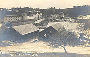
of 7,452. Buxton includes the villages of Salmon Falls, Chicopee, Groveville, Bar Mills, West Buxton and Buxton Center.
as Narragansett Number 1 in 1728. It was assigned to Philemon Dane of Ipswich
, Massachusetts
and 119 other veterans (or their heirs) who had fought in King Philip's War
against the Narragansett
Indians
in 1675. Settlement was attempted in the early 1740s but abandoned because of the ongoing French and Indian Wars
.
The first permanent settlement commenced in fall of 1750 near Salmon Falls, which was within protection of the stockade
d blockhouse
and trading post
built in 1728 a half mile below Union Falls in present-day Dayton
. Amos Chase
was one of the pioneers of the town, and his daughter was said to be the first white child born in Buxton. He was a prominent figure in the area, one of the largest taxpayers, and was the first deacon of the Congregational Church in Pepperellborough (present-day Saco, ME). The first schoolhouse in Buxton was established in 1761 by Rev. Silas Moody. Narragansett Number 1 was incorporated in 1772 as Buxton. It was named by its minister, Rev. Paul Coffin for Buxton, England
, for unknown reasons. Buxton, England is often incorrectly cited as the home of his ancestors, but that was Brixton as noted on page 7 of the cited source(2).
Settlers found the land generally level and suited for farming. Chief crops were corn
, potato
es and hay
. Buxton also provided excellent water power sites. The first sawmill
was on the Little River, a tributary of the Presumpscot River
. A gristmill
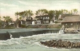
called Bog Mill was built at the outlet of Bonny Eagle Pond. The biggest mills, however, were located at the series of falls
on the Saco River
. Salmon Falls had sawmills capable of turning out four million feet of lumber
annually. Bar Mills had gristmills and a box mill. Moderation Falls in West Buxton had sawmills, heading mills and woolen
textile
mills which produced about 936,000 yards of cloth annually. Buxton's mill town
prosperity left behind fine architecture
. Listed on the National Register of Historic Places
are Elden's Store, the Buxton Powder House, the First Congregational Church, Royal Brewster House and Salmon Falls (East) Historic District
.
, the town has a total area of 41.2 square miles (106.7 km²), of which 40.5 square miles (104.9 km²) is land and 0.7 square miles (1.8 km²) is water
. Buxton is drained by Little River and the Saco River
. Bonny Eagle Pond is a 211 acre (0.85388746 km²) body of water located in the northern part of the town.
Buxton borders the towns of Gorham
to the northeast, Scarborough and Saco
to the southeast, Dayton
to the south, Hollis
to the west and Standish
to the northwest.
 As of the census
of 2000, there were 7,452 people, 2,804 households, and 2,094 families residing in the town. The population density
was 184.0 people per square mile (71.1/km²). There were 2,930 housing units at an average density of 72.4 per square mile (27.9/km²). The racial makeup of the town was 97.83% White, 0.42% African American, 0.24% Native American, 0.59% Asian, 0.12% Pacific Islander, 0.19% from other races
, and 0.62% from two or more races. Hispanic or Latino of any race were 0.55% of the population.
There were 2,804 households out of which 35.3% had children under the age of 18 living with them, 62.6% were married couples
living together, 8.7% had a female householder with no husband present, and 25.3% were non-families. 18.0% of all households were made up of individuals and 5.8% had someone living alone who was 65 years of age or older. The average household size was 2.65 and the average family size was 3.00.
 In the town the population was spread out with 25.1% under the age of 18, 6.8% from 18 to 24, 33.1% from 25 to 44, 25.5% from 45 to 64, and 9.5% who were 65 years of age or older. The median age was 37 years. For every 100 females there were 101.1 males. For every 100 females age 18 and over, there were 98.4 males.
The median income for a household in the town was $48,958, and the median income for a family was $52,845. Males had a median income of $35,628 versus $27,400 for females. The per capita income
for the town was $20,179. About 3.2% of families and 6.0% of the population were below the poverty line, including 5.1% of those under age 18 and 16.5% of those age 65 or over.
(based on Rita Hayworth and the Shawshank Redemption by Maine native Stephen King), Buxton is the site of the rock wall where Red goes after being released from prison to retrieve a message from his friend Andy Dufresne, who escaped from prison a few months earlier.
New England town
The New England town is the basic unit of local government in each of the six New England states. Without a direct counterpart in most other U.S. states, New England towns are conceptually similar to civil townships in other states, but are incorporated, possessing powers like cities in other...
in York County
York County, Maine
York County is a county located in the U.S. state of Maine. In 2010, the population was 197,131. Its county seat is Alfred.Founded in 1636, it is the oldest county in Maine and one of the oldest in the United States....
, Maine
Maine
Maine is a state in the New England region of the northeastern United States, bordered by the Atlantic Ocean to the east and south, New Hampshire to the west, and the Canadian provinces of Quebec to the northwest and New Brunswick to the northeast. Maine is both the northernmost and easternmost...
, United States
United States
The United States of America is a federal constitutional republic comprising fifty states and a federal district...
. It is part of the Portland
Portland, Maine
Portland is the largest city in Maine and is the county seat of Cumberland County. The 2010 city population was 66,194, growing 3 percent since the census of 2000...
–South Portland
South Portland, Maine
South Portland is a city in Cumberland County, Maine, United States, and is the fourth-largest city in the state. Founded in 1895, as of the 2010 census, the city population was 25,002. Known for its working waterfront, South Portland is situated on Portland Harbor and overlooks the skyline of...
–Biddeford
Biddeford, Maine
Biddeford is a town in York County, Maine, United States. It is the largest town in the county, and is the sixth-largest in the state. It is the most southerly incorporated town in the state and the principal commercial center of York County. The population was 21,277 at the 2010 census...
, Maine Metropolitan Statistical Area
Portland-South Portland-Biddeford metropolitan area
The Portland–South Portland–Biddeford Metropolitan Statistical Area, also known as Greater Portland, as defined by the United States Census Bureau, is an area consisting of three counties in Maine, anchored by the city of Portland and the smaller cities of South Portland and Biddeford...
. As of the 2000 census, the town had a total population
Population
A population is all the organisms that both belong to the same group or species and live in the same geographical area. The area that is used to define a sexual population is such that inter-breeding is possible between any pair within the area and more probable than cross-breeding with individuals...
of 7,452. Buxton includes the villages of Salmon Falls, Chicopee, Groveville, Bar Mills, West Buxton and Buxton Center.
History
The township was granted by the Massachusetts General CourtMassachusetts General Court
The Massachusetts General Court is the state legislature of the Commonwealth of Massachusetts. The name "General Court" is a hold-over from the Colonial Era, when this body also sat in judgment of judicial appeals cases...
as Narragansett Number 1 in 1728. It was assigned to Philemon Dane of Ipswich
Ipswich, Massachusetts
Ipswich is a coastal town in Essex County, Massachusetts, United States. The population was 12,987 at the 2000 census. Home to Willowdale State Forest and Sandy Point State Reservation, Ipswich includes the southern part of Plum Island...
, Massachusetts
Massachusetts
The Commonwealth of Massachusetts is a state in the New England region of the northeastern United States of America. It is bordered by Rhode Island and Connecticut to the south, New York to the west, and Vermont and New Hampshire to the north; at its east lies the Atlantic Ocean. As of the 2010...
and 119 other veterans (or their heirs) who had fought in King Philip's War
King Philip's War
King Philip's War, sometimes called Metacom's War, Metacomet's War, or Metacom's Rebellion, was an armed conflict between Native American inhabitants of present-day southern New England and English colonists and their Native American allies in 1675–76. The war is named after the main leader of the...
against the Narragansett
Narragansett (tribe)
The Narragansett tribe are an Algonquian Native American tribe from Rhode Island. In 1983 they regained federal recognition as the Narragansett Indian Tribe of Rhode Island. In 2009, the United States Supreme Court ruled against their request that the Department of Interior take land into trust...
Indians
Indigenous peoples of the Americas
The indigenous peoples of the Americas are the pre-Columbian inhabitants of North and South America, their descendants and other ethnic groups who are identified with those peoples. Indigenous peoples are known in Canada as Aboriginal peoples, and in the United States as Native Americans...
in 1675. Settlement was attempted in the early 1740s but abandoned because of the ongoing French and Indian Wars
French and Indian Wars
The French and Indian Wars is a name used in the United States for a series of conflicts lasting 74 years in North America that represented colonial events related to the European dynastic wars...
.
The first permanent settlement commenced in fall of 1750 near Salmon Falls, which was within protection of the stockade
Stockade
A stockade is an enclosure of palisades and tall walls made of logs placed side by side vertically with the tops sharpened to provide security.-Stockade as a security fence:...
d blockhouse
Blockhouse
In military science, a blockhouse is a small, isolated fort in the form of a single building. It serves as a defensive strong point against any enemy that does not possess siege equipment or, in modern times, artillery...
and trading post
Trading post
A trading post was a place or establishment in historic Northern America where the trading of goods took place. The preferred travel route to a trading post or between trading posts, was known as a trade route....
built in 1728 a half mile below Union Falls in present-day Dayton
Dayton, Maine
Dayton is a town in York County, Maine, United States. The population was 1,805 at the 2000 census. It is part of the Portland–South Portland–Biddeford, Maine metropolitan statistical area. Dayton is one of the smallest towns in York County....
. Amos Chase
Amos Chase
Amos Chase was the first deacon of the first Congregational Church and one of the founders of Pepperellborough, ME ....
was one of the pioneers of the town, and his daughter was said to be the first white child born in Buxton. He was a prominent figure in the area, one of the largest taxpayers, and was the first deacon of the Congregational Church in Pepperellborough (present-day Saco, ME). The first schoolhouse in Buxton was established in 1761 by Rev. Silas Moody. Narragansett Number 1 was incorporated in 1772 as Buxton. It was named by its minister, Rev. Paul Coffin for Buxton, England
England
England is a country that is part of the United Kingdom. It shares land borders with Scotland to the north and Wales to the west; the Irish Sea is to the north west, the Celtic Sea to the south west, with the North Sea to the east and the English Channel to the south separating it from continental...
, for unknown reasons. Buxton, England is often incorrectly cited as the home of his ancestors, but that was Brixton as noted on page 7 of the cited source(2).
Settlers found the land generally level and suited for farming. Chief crops were corn
Maize
Maize known in many English-speaking countries as corn or mielie/mealie, is a grain domesticated by indigenous peoples in Mesoamerica in prehistoric times. The leafy stalk produces ears which contain seeds called kernels. Though technically a grain, maize kernels are used in cooking as a vegetable...
, potato
Potato
The potato is a starchy, tuberous crop from the perennial Solanum tuberosum of the Solanaceae family . The word potato may refer to the plant itself as well as the edible tuber. In the region of the Andes, there are some other closely related cultivated potato species...
es and hay
Hay
Hay is grass, legumes or other herbaceous plants that have been cut, dried, and stored for use as animal fodder, particularly for grazing livestock such as cattle, horses, goats, and sheep. Hay is also fed to pets such as rabbits and guinea pigs...
. Buxton also provided excellent water power sites. The first sawmill
Sawmill
A sawmill is a facility where logs are cut into boards.-Sawmill process:A sawmill's basic operation is much like those of hundreds of years ago; a log enters on one end and dimensional lumber exits on the other end....
was on the Little River, a tributary of the Presumpscot River
Presumpscot River
The Presumpscot River is a river located in Cumberland County, Maine. It is the main outlet of Sebago Lake.-Course:The river flows through the communities of Standish, Windham, Gorham, Westbrook, Portland, and Falmouth before emptying into Casco Bay at Falmouth...
. A gristmill
Gristmill
The terms gristmill or grist mill can refer either to a building in which grain is ground into flour, or to the grinding mechanism itself.- Early history :...
called Bog Mill was built at the outlet of Bonny Eagle Pond. The biggest mills, however, were located at the series of falls
Waterfall
A waterfall is a place where flowing water rapidly drops in elevation as it flows over a steep region or a cliff.-Formation:Waterfalls are commonly formed when a river is young. At these times the channel is often narrow and deep. When the river courses over resistant bedrock, erosion happens...
on the Saco River
Saco River
The Saco River is a river in northeastern New Hampshire and southwestern Maine in the United States. It drains a rural area of of forests and farmlands west and southwest of Portland, emptying into the Atlantic Ocean at Saco Bay, from its source. It supplies drinking water to roughly 250,000...
. Salmon Falls had sawmills capable of turning out four million feet of lumber
Lumber
Lumber or timber is wood in any of its stages from felling through readiness for use as structural material for construction, or wood pulp for paper production....
annually. Bar Mills had gristmills and a box mill. Moderation Falls in West Buxton had sawmills, heading mills and woolen
Woolen
Woolen or woollen is a type of yarn made from carded wool. Woolen yarn is soft, light, stretchy, and full of air. It is thus a good insulator, and makes a good knitting yarn...
textile
Textile
A textile or cloth is a flexible woven material consisting of a network of natural or artificial fibres often referred to as thread or yarn. Yarn is produced by spinning raw fibres of wool, flax, cotton, or other material to produce long strands...
mills which produced about 936,000 yards of cloth annually. Buxton's mill town
Mill town
A mill town, also known as factory town or mill village, is typically a settlement that developed around one or more mills or factories .- United Kingdom:...
prosperity left behind fine architecture
Architecture
Architecture is both the process and product of planning, designing and construction. Architectural works, in the material form of buildings, are often perceived as cultural and political symbols and as works of art...
. Listed on the National Register of Historic Places
National Register of Historic Places
The National Register of Historic Places is the United States government's official list of districts, sites, buildings, structures, and objects deemed worthy of preservation...
are Elden's Store, the Buxton Powder House, the First Congregational Church, Royal Brewster House and Salmon Falls (East) Historic District
Historic district
A historic district or heritage district is a section of a city which contains older buildings considered valuable for historical or architectural reasons. In some countries, historic districts receive legal protection from development....
.
Geography
According to the United States Census BureauUnited States Census Bureau
The United States Census Bureau is the government agency that is responsible for the United States Census. It also gathers other national demographic and economic data...
, the town has a total area of 41.2 square miles (106.7 km²), of which 40.5 square miles (104.9 km²) is land and 0.7 square miles (1.8 km²) is water
Water
Water is a chemical substance with the chemical formula H2O. A water molecule contains one oxygen and two hydrogen atoms connected by covalent bonds. Water is a liquid at ambient conditions, but it often co-exists on Earth with its solid state, ice, and gaseous state . Water also exists in a...
. Buxton is drained by Little River and the Saco River
Saco River
The Saco River is a river in northeastern New Hampshire and southwestern Maine in the United States. It drains a rural area of of forests and farmlands west and southwest of Portland, emptying into the Atlantic Ocean at Saco Bay, from its source. It supplies drinking water to roughly 250,000...
. Bonny Eagle Pond is a 211 acre (0.85388746 km²) body of water located in the northern part of the town.
Buxton borders the towns of Gorham
Gorham, Maine
Gorham is a town in Cumberland County, Maine, United States. The population was 16,381 at the 2010 census. In addition to an urban village center known as Gorham Village or simply "the Village," the town also encompasses a number of smaller, unincorporated villages and hamlets with distinct...
to the northeast, Scarborough and Saco
Saco, Maine
Saco is a city in York County, Maine, United States. The population was 18,482 at the 2010 census. It is home to Ferry Beach State Park, Funtown Splashtown USA, Thornton Academy, as well as General Dynamics Armament Systems , a subsidiary of the defense contractor General Dynamics...
to the southeast, Dayton
Dayton, Maine
Dayton is a town in York County, Maine, United States. The population was 1,805 at the 2000 census. It is part of the Portland–South Portland–Biddeford, Maine metropolitan statistical area. Dayton is one of the smallest towns in York County....
to the south, Hollis
Hollis, Maine
Hollis is a town in York County, Maine, United States. The population was 4,281 at the 2010 census. Hollis is a rural bedroom community of Portland and is part of the Portland–South Portland–Biddeford, Maine metropolitan statistical area.-History:...
to the west and Standish
Standish, Maine
Standish is a town in Cumberland County, Maine, United States. The population was 9,874 at the 2010 census. It includes the villages of Standish Corner, Sebago Lake Village and Steep Falls, and the localities known as Richville, Standish Neck and Two Trails...
to the northwest.
Demographics
Census
A census is the procedure of systematically acquiring and recording information about the members of a given population. It is a regularly occurring and official count of a particular population. The term is used mostly in connection with national population and housing censuses; other common...
of 2000, there were 7,452 people, 2,804 households, and 2,094 families residing in the town. The population density
Population density
Population density is a measurement of population per unit area or unit volume. It is frequently applied to living organisms, and particularly to humans...
was 184.0 people per square mile (71.1/km²). There were 2,930 housing units at an average density of 72.4 per square mile (27.9/km²). The racial makeup of the town was 97.83% White, 0.42% African American, 0.24% Native American, 0.59% Asian, 0.12% Pacific Islander, 0.19% from other races
Race (United States Census)
Race and ethnicity in the United States Census, as defined by the Federal Office of Management and Budget and the United States Census Bureau, are self-identification data items in which residents choose the race or races with which they most closely identify, and indicate whether or not they are...
, and 0.62% from two or more races. Hispanic or Latino of any race were 0.55% of the population.
There were 2,804 households out of which 35.3% had children under the age of 18 living with them, 62.6% were married couples
Marriage
Marriage is a social union or legal contract between people that creates kinship. It is an institution in which interpersonal relationships, usually intimate and sexual, are acknowledged in a variety of ways, depending on the culture or subculture in which it is found...
living together, 8.7% had a female householder with no husband present, and 25.3% were non-families. 18.0% of all households were made up of individuals and 5.8% had someone living alone who was 65 years of age or older. The average household size was 2.65 and the average family size was 3.00.
The median income for a household in the town was $48,958, and the median income for a family was $52,845. Males had a median income of $35,628 versus $27,400 for females. The per capita income
Per capita income
Per capita income or income per person is a measure of mean income within an economic aggregate, such as a country or city. It is calculated by taking a measure of all sources of income in the aggregate and dividing it by the total population...
for the town was $20,179. About 3.2% of families and 6.0% of the population were below the poverty line, including 5.1% of those under age 18 and 16.5% of those age 65 or over.
Sites of interest
- Pine Tree Garage
- Buxton-Hollis Historical Society & Museum
- Tory Hill Meeting House (1822)
- Brewster Mansion (1805)
- Powder House (1813)
Buxton in popular culture
In the movie The Shawshank RedemptionThe Shawshank Redemption
The Shawshank Redemption is a 1994 American drama film written and directed by Frank Darabont and starring Tim Robbins and Morgan Freeman....
(based on Rita Hayworth and the Shawshank Redemption by Maine native Stephen King), Buxton is the site of the rock wall where Red goes after being released from prison to retrieve a message from his friend Andy Dufresne, who escaped from prison a few months earlier.
Notable people
- John Brewster Jr., artist
- Amos ChaseAmos ChaseAmos Chase was the first deacon of the first Congregational Church and one of the founders of Pepperellborough, ME ....
, pioneer settler of Buxton - Mark H. Dunnell, congressman
- Alanson M. KimballAlanson M. KimballAlanson Mellen Kimball was born on March 12, 1827 in Buxton, Maine, in York County, Maine and was a member of the United States House of Representatives from Wisconsin. He moved to Wisconsin in 1852 and engaged in agricultural and mercantile pursuits, later serving in the Wisconsin State Senate in...
, congressman - Gibeon BradburyGibeon BradburyGibeon Bradbury was a painter from Buxton, Maine. Bradbury was born in a particular section of Buxton entitled Salmon Falls, an area on a large hill near the Saco River. The son of Nathaniel Scamman Bradbury and Lucy Sawyer Bradbury, Gibeon spent most of his life in Salmon Falls.Bradbury began a...
, painter - Julia Spencer-FlemingJulia Spencer-FlemingJulia Spencer-Fleming is an American novelist.She lives in Maine with her husband, 3 children, a dog, and two cats.-Rev. Clare Fergusson/Russ Van Alstyne series :...
, author
External links
- Town of Buxton, Maine
- Buxton News
- Berry Library
- West Buxton Public Library
- Dorcas Society of Hollis & Buxton, Maine
- Buxton at Maine.gov
- Epodunk Town Profile