
Hillsborough, New Hampshire
Encyclopedia
Hillsborough, frequently spelled Hillsboro, is a town in Hillsborough County
, New Hampshire
, United States
. The population was 6,011 at the 2010 census. The town is home to Fox State Forest and part of Low State Forest.
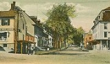
The main village of the town, where 1,976 people resided at the 2010 census, is defined as the Hillsborough census-designated place
(CDP), and encompasses the central urban area of the town, located along the Contoocook River
at the junction of New Hampshire Route 149
with Henniker Street and Main Street. The town also includes the villages of Hillsborough Center, Hillsborough Upper Village, Hillsborough Lower Village, and Emerald Lake Village.
 The town was first granted in 1735 by Colonial
Governor Jonathan Belcher
as "Number Seven," one in a line of nine towns set up as defense barriers against Indian
attacks. The towns were renamed following the 1741 establishment of New Hampshire
as a separate province. Settled in 1741, the town was granted in 1748 by Governor Benning Wentworth
as "Hillsborough," named for Sir Wills Hill
, Earl of Hillsborough. It would be incorporated in 1772 by Governor John Wentworth
.
Hillsborough is the birthplace in 1804 of Franklin Pierce
, 14th president of the United States
, and the only president from New Hampshire. The Pierce Homestead
was built in 1804 by his father, Benjamin Pierce
, a general in the Revolutionary War
, and twice governor of New Hampshire. Restored in 1925, the home was designated a National Historic Landmark
in 1961. Listed on the National Register of Historic Places
, the house is today a museum owned by the state, and operated by the Hillsborough Historical Society.

, the town has a total area of 44.6 square miles (115.5 km²), of which 43.6 sq mi (112.9 km²) is land and 1 sq mi (2.6 km²) is water, comprising 2.24% of the town.
According to the United States Census Bureau
, the town center, or census-designated place
, has a total area of 1.6 sq mi (4.1 km²).
The highest point in Hillsborough is Thompson Hill, at 1768 feet (538.9 m) above sea level
, in the northern part of town. Hillsborough is drained by the Contoocook River
, in addition to Beard's and Sand brooks. Part of Franklin Pierce Lake
is in the southwest. The town lies fully within the Merrimack River
watershed
.
Hillsborough is bordered by Windsor
to the southwest, Washington
to the northwest, Bradford
to the north, Henniker
to the east, and Antrim
and Deering
to the south.
 As of the census
of 2000, there were 4,928 people, 1,922 households, and 1,312 families residing in the town. The population density
was 112.9 people per square mile (43.6/km²). There were 2,326 housing units at an average density of 53.3 per square mile (20.6/km²). The racial makeup of the town was 97.46% White, 0.18% Black or African American
, 0.45% Native American, 0.93% Asian, 0.12% from other races
, and 0.85% from two or more races. Hispanic or Latino of any race were 0.53% of the population.
There were 1,922 households out of which 33.7% had children under the age of 18 living with them, 53.9% were married couples
living together, 10.0% had a female householder with no husband present, and 31.7% were non-families. 23.8% of all households were made up of individuals and 8.0% had someone living alone who was 65 years of age or older. The average household size was 2.55 and the average family size was 3.02.
 In the town the population was spread out with 26.5% under the age of 18, 6.7% from 18 to 24, 30.3% from 25 to 44, 23.7% from 45 to 64, and 12.7% who were 65 years of age or older. The median age was 38 years. For every 100 females there were 95.6 males. For every 100 females age 18 and over, there were 94.4 males.
The median income for a household in the town was $44,500, and the median income for a family was $50,445. Males had a median income of $37,016 versus $24,795 for females. The per capita income
for the town was $20,122. About 6.7% of families and 9.8% of the population were below the poverty line, including 12.7% of those under age 18 and 10.1% of those age 65 or over.
of 2000, there were 1,842 people, 760 households, and 455 families residing in the primary settlement, or census-designated place
(CDP). The population density
was 1,130.5 people per square mile (436.3/km²). There were 809 housing units at an average density of 496.5 per square mile (191.6/km²). The racial makeup of the CDP was 97.29% White, 0.11% Black or African American
, 0.16% Native American, 1.47% Asian, 0.16% from other races
, and 0.81% from two or more races. Hispanic or Latino of any race were 0.33% of the population.
There were 760 households out of which 30.9% had children under the age of 18 living with them, 41.1% were married couples
living together, 14.9% had a female householder with no husband present, and 40.1% were non-families. 31.8% of all households were made up of individuals and 11.3% had someone living alone who was 65 years of age or older. The average household size was 2.38 and the average family size was 3.01.
In the CDP the population was spread out with 26.3% under the age of 18, 8.2% from 18 to 24, 29.6% from 25 to 44, 21.6% from 45 to 64, and 14.4% who were 65 years of age or older. The median age was 36 years. For every 100 females there were 88.3 males. For every 100 females age 18 and over, there were 87.6 males.
The median income for a household in the CDP was $31,855, and the median income for a family was $47,438. Males had a median income of $38,077 versus $22,813 for females. The per capita income
for the CDP was $19,125. About 10.6% of families and 14.1% of the population were below the poverty line, including 21.0% of those under age 18 and 9.5% of those age 65 or over.
Hillsborough County, New Hampshire
-Demographics:As of the census of 2000, there were 380,841 people, 144,455 households, and 98,807 families residing in the county. The population density was 435 people per square mile . There were 149,961 housing units at an average density of 171 per square mile...
, New Hampshire
New Hampshire
New Hampshire is a state in the New England region of the northeastern United States of America. The state was named after the southern English county of Hampshire. It is bordered by Massachusetts to the south, Vermont to the west, Maine and the Atlantic Ocean to the east, and the Canadian...
, United States
United States
The United States of America is a federal constitutional republic comprising fifty states and a federal district...
. The population was 6,011 at the 2010 census. The town is home to Fox State Forest and part of Low State Forest.
The main village of the town, where 1,976 people resided at the 2010 census, is defined as the Hillsborough census-designated place
Census-designated place
A census-designated place is a concentration of population identified by the United States Census Bureau for statistical purposes. CDPs are delineated for each decennial census as the statistical counterparts of incorporated places such as cities, towns and villages...
(CDP), and encompasses the central urban area of the town, located along the Contoocook River
Contoocook River
The Contoocook River is a river in New Hampshire. It flows from Pool Pond and Contoocook Lake on the Jaffrey/Rindge border to Penacook , where it empties into the Merrimack River. It is one of only a few rivers in New Hampshire that flow in a predominantly northward direction...
at the junction of New Hampshire Route 149
New Hampshire Route 149
New Hampshire Route 149 is a long secondary east–west state highway in Hillsborough County in the southern part of the U.S. state of New Hampshire. The road runs between the towns of Weare and Hillsborough....
with Henniker Street and Main Street. The town also includes the villages of Hillsborough Center, Hillsborough Upper Village, Hillsborough Lower Village, and Emerald Lake Village.
History
Colony
In politics and history, a colony is a territory under the immediate political control of a state. For colonies in antiquity, city-states would often found their own colonies. Some colonies were historically countries, while others were territories without definite statehood from their inception....
Governor Jonathan Belcher
Jonathan Belcher
Jonathan Belcher was colonial governor of the British provinces of Massachusetts Bay, New Hampshire, and New Jersey.-Early life:Jonathan Belcher was born in Cambridge, Province of Massachusetts Bay, in 1682...
as "Number Seven," one in a line of nine towns set up as defense barriers against Indian
Indigenous peoples of the Americas
The indigenous peoples of the Americas are the pre-Columbian inhabitants of North and South America, their descendants and other ethnic groups who are identified with those peoples. Indigenous peoples are known in Canada as Aboriginal peoples, and in the United States as Native Americans...
attacks. The towns were renamed following the 1741 establishment of New Hampshire
New Hampshire
New Hampshire is a state in the New England region of the northeastern United States of America. The state was named after the southern English county of Hampshire. It is bordered by Massachusetts to the south, Vermont to the west, Maine and the Atlantic Ocean to the east, and the Canadian...
as a separate province. Settled in 1741, the town was granted in 1748 by Governor Benning Wentworth
Benning Wentworth
Benning Wentworth was the colonial governor of New Hampshire from 1741 to 1766.-Biography:The eldest child of the John Wentworth who had been Lieutenant Governor, he was born and died in Portsmouth, New Hampshire. Wentworth graduated from Harvard College in 1715...
as "Hillsborough," named for Sir Wills Hill
Wills Hill, 1st Marquess of Downshire
Wills Hill, 1st Marquess of Downshire PC , known as the Viscount Hillsborough from 1742 to 1751 and as the Earl of Hillsborough from 1751 to 1789, was a British politician of the Georgian era...
, Earl of Hillsborough. It would be incorporated in 1772 by Governor John Wentworth
John Wentworth (governor)
Sir John Wentworth, 1st Baronet was the British colonial governor of New Hampshire at the time of the American Revolution. He was later also Lieutenant-Governor of Nova Scotia.-Early life:...
.
Hillsborough is the birthplace in 1804 of Franklin Pierce
Franklin Pierce
Franklin Pierce was the 14th President of the United States and is the only President from New Hampshire. Pierce was a Democrat and a "doughface" who served in the U.S. House of Representatives and the Senate. Pierce took part in the Mexican-American War and became a brigadier general in the Army...
, 14th president of the United States
United States
The United States of America is a federal constitutional republic comprising fifty states and a federal district...
, and the only president from New Hampshire. The Pierce Homestead
Franklin Pierce Homestead
The Franklin Pierce Homestead was the childhood home of the fourteenth President of the United States, Franklin Pierce. Located in Hillsborough, New Hampshire, the home was built in 1804 by Pierce's father, Benjamin Pierce. The home is one of Franklin Pierce's probable places of birth, the other...
was built in 1804 by his father, Benjamin Pierce
Benjamin Pierce (governor)
Benjamin Pierce was an American Democratic-Republican politician. He served as Governor of New Hampshire from 1827 to 1828 and from 1829 to 1830.-Biography:...
, a general in the Revolutionary War
American Revolutionary War
The American Revolutionary War , the American War of Independence, or simply the Revolutionary War, began as a war between the Kingdom of Great Britain and thirteen British colonies in North America, and ended in a global war between several European great powers.The war was the result of the...
, and twice governor of New Hampshire. Restored in 1925, the home was designated a National Historic Landmark
National Historic Landmark
A National Historic Landmark is a building, site, structure, object, or district, that is officially recognized by the United States government for its historical significance...
in 1961. Listed on the National Register of Historic Places
National Register of Historic Places
The National Register of Historic Places is the United States government's official list of districts, sites, buildings, structures, and objects deemed worthy of preservation...
, the house is today a museum owned by the state, and operated by the Hillsborough Historical Society.
Notable inhabitants
- Franklin PierceFranklin PierceFranklin Pierce was the 14th President of the United States and is the only President from New Hampshire. Pierce was a Democrat and a "doughface" who served in the U.S. House of Representatives and the Senate. Pierce took part in the Mexican-American War and became a brigadier general in the Army...
, 14th President of the United StatesPresident of the United StatesThe President of the United States of America is the head of state and head of government of the United States. The president leads the executive branch of the federal government and is the commander-in-chief of the United States Armed Forces.... - Benjamin Pierce CheneyBenjamin Pierce CheneyBenjamin Pierce Cheney was an American businessman, and a founder of the firm that became American Express.-Early life:Cheney was born in Hillsborough, New Hampshire on August 12, 1815, to Jesse and Alice Cheney. The family were descended from John Cheney, who was recorded in Roxbury,...
, a founder of American ExpressAmerican ExpressAmerican Express Company or AmEx, is an American multinational financial services corporation headquartered in Three World Financial Center, Manhattan, New York City, New York, United States. Founded in 1850, it is one of the 30 components of the Dow Jones Industrial Average. The company is best... - Benjamin Franklin KeithBenjamin Franklin KeithBenjamin Franklin Keith was an American vaudeville theatre owner, highly influential in the evolution of variety theater into vaudeville.-Early years:...
, theatrical impressario - John Butler SmithJohn Butler SmithJohn Butler Smith was an American manufacturer and Republican politician from Hillsborough, New Hampshire. Born in 1838 in Saxtons River, Vermont, he served New Hampshire as a member of the Governor's Council, and as Governor. Smith Memorial Congregational Church, U.C.C in the town is named for...
, governor and manufacturer
Geography
According to the United States Census BureauUnited States Census Bureau
The United States Census Bureau is the government agency that is responsible for the United States Census. It also gathers other national demographic and economic data...
, the town has a total area of 44.6 square miles (115.5 km²), of which 43.6 sq mi (112.9 km²) is land and 1 sq mi (2.6 km²) is water, comprising 2.24% of the town.
According to the United States Census Bureau
United States Census Bureau
The United States Census Bureau is the government agency that is responsible for the United States Census. It also gathers other national demographic and economic data...
, the town center, or census-designated place
Census-designated place
A census-designated place is a concentration of population identified by the United States Census Bureau for statistical purposes. CDPs are delineated for each decennial census as the statistical counterparts of incorporated places such as cities, towns and villages...
, has a total area of 1.6 sq mi (4.1 km²).
The highest point in Hillsborough is Thompson Hill, at 1768 feet (538.9 m) above sea level
Sea level
Mean sea level is a measure of the average height of the ocean's surface ; used as a standard in reckoning land elevation...
, in the northern part of town. Hillsborough is drained by the Contoocook River
Contoocook River
The Contoocook River is a river in New Hampshire. It flows from Pool Pond and Contoocook Lake on the Jaffrey/Rindge border to Penacook , where it empties into the Merrimack River. It is one of only a few rivers in New Hampshire that flow in a predominantly northward direction...
, in addition to Beard's and Sand brooks. Part of Franklin Pierce Lake
Franklin Pierce Lake
Franklin Pierce Lake is a reservoir located in Hillsborough County in southern New Hampshire, United States, in the towns of Hillsborough and Antrim. It is named for Franklin Pierce, the 14th president of the United States, who was born in Hillsborough at a site now inundated by the lake...
is in the southwest. The town lies fully within the Merrimack River
Merrimack River
The Merrimack River is a river in the northeastern United States. It rises at the confluence of the Pemigewasset and Winnipesaukee rivers in Franklin, New Hampshire, flows southward into Massachusetts, and then flows northeast until it empties into the Atlantic Ocean at Newburyport...
watershed
Drainage basin
A drainage basin is an extent or an area of land where surface water from rain and melting snow or ice converges to a single point, usually the exit of the basin, where the waters join another waterbody, such as a river, lake, reservoir, estuary, wetland, sea, or ocean...
.
Hillsborough is bordered by Windsor
Windsor, New Hampshire
Windsor is a town in Hillsborough County, New Hampshire, United States. The population was 224 at the 2010 census. It is the location of the Wediko Children's Services Summer Program and of , a summer adventure and travel camp founded in 1961.- History :...
to the southwest, Washington
Washington, New Hampshire
Washington is a town in Sullivan County, New Hampshire, United States. The population was 1,123 at the 2010 census. Situated in a hilly, rocky, forested area, and with 26 lakes and ponds, Washington is a picturesque resort area...
to the northwest, Bradford
Bradford, New Hampshire
Bradford is a town in Merrimack County, New Hampshire, United States. The population was 1,650 at the 2010 census. The main village of the town, where 356 people resided at the 2010 census, is defined as the Bradford census-designated place , and is located west of the junction of New Hampshire...
to the north, Henniker
Henniker, New Hampshire
Henniker is a town in Merrimack County, New Hampshire, United States. As of the 2010 census, the town had a total population of 4,836. Henniker is home to New England College, Ames State Forest and Craney Hill State Forest....
to the east, and Antrim
Antrim, New Hampshire
Antrim is a town in Hillsborough County, New Hampshire, United States. The population was 2,637 at the 2010 census. The primary settlement in the town, where 1,397 people resided at the 2010 census, is defined as the Antrim census-designated place and is located at the intersection of U.S. Route...
and Deering
Deering, New Hampshire
Deering is a town in Hillsborough County, New Hampshire, United States. The population was 1,912 at the 2010 census.-History:First settled about 1765, the town was incorporated on January 17, 1774 by John Wentworth, governor of the province of New Hampshire...
to the south.
Demographics
Census
A census is the procedure of systematically acquiring and recording information about the members of a given population. It is a regularly occurring and official count of a particular population. The term is used mostly in connection with national population and housing censuses; other common...
of 2000, there were 4,928 people, 1,922 households, and 1,312 families residing in the town. The population density
Population density
Population density is a measurement of population per unit area or unit volume. It is frequently applied to living organisms, and particularly to humans...
was 112.9 people per square mile (43.6/km²). There were 2,326 housing units at an average density of 53.3 per square mile (20.6/km²). The racial makeup of the town was 97.46% White, 0.18% Black or African American
Race (United States Census)
Race and ethnicity in the United States Census, as defined by the Federal Office of Management and Budget and the United States Census Bureau, are self-identification data items in which residents choose the race or races with which they most closely identify, and indicate whether or not they are...
, 0.45% Native American, 0.93% Asian, 0.12% from other races
Race (United States Census)
Race and ethnicity in the United States Census, as defined by the Federal Office of Management and Budget and the United States Census Bureau, are self-identification data items in which residents choose the race or races with which they most closely identify, and indicate whether or not they are...
, and 0.85% from two or more races. Hispanic or Latino of any race were 0.53% of the population.
There were 1,922 households out of which 33.7% had children under the age of 18 living with them, 53.9% were married couples
Marriage
Marriage is a social union or legal contract between people that creates kinship. It is an institution in which interpersonal relationships, usually intimate and sexual, are acknowledged in a variety of ways, depending on the culture or subculture in which it is found...
living together, 10.0% had a female householder with no husband present, and 31.7% were non-families. 23.8% of all households were made up of individuals and 8.0% had someone living alone who was 65 years of age or older. The average household size was 2.55 and the average family size was 3.02.
The median income for a household in the town was $44,500, and the median income for a family was $50,445. Males had a median income of $37,016 versus $24,795 for females. The per capita income
Per capita income
Per capita income or income per person is a measure of mean income within an economic aggregate, such as a country or city. It is calculated by taking a measure of all sources of income in the aggregate and dividing it by the total population...
for the town was $20,122. About 6.7% of families and 9.8% of the population were below the poverty line, including 12.7% of those under age 18 and 10.1% of those age 65 or over.
Town center
As of the censusCensus
A census is the procedure of systematically acquiring and recording information about the members of a given population. It is a regularly occurring and official count of a particular population. The term is used mostly in connection with national population and housing censuses; other common...
of 2000, there were 1,842 people, 760 households, and 455 families residing in the primary settlement, or census-designated place
Census-designated place
A census-designated place is a concentration of population identified by the United States Census Bureau for statistical purposes. CDPs are delineated for each decennial census as the statistical counterparts of incorporated places such as cities, towns and villages...
(CDP). The population density
Population density
Population density is a measurement of population per unit area or unit volume. It is frequently applied to living organisms, and particularly to humans...
was 1,130.5 people per square mile (436.3/km²). There were 809 housing units at an average density of 496.5 per square mile (191.6/km²). The racial makeup of the CDP was 97.29% White, 0.11% Black or African American
Race (United States Census)
Race and ethnicity in the United States Census, as defined by the Federal Office of Management and Budget and the United States Census Bureau, are self-identification data items in which residents choose the race or races with which they most closely identify, and indicate whether or not they are...
, 0.16% Native American, 1.47% Asian, 0.16% from other races
Race (United States Census)
Race and ethnicity in the United States Census, as defined by the Federal Office of Management and Budget and the United States Census Bureau, are self-identification data items in which residents choose the race or races with which they most closely identify, and indicate whether or not they are...
, and 0.81% from two or more races. Hispanic or Latino of any race were 0.33% of the population.
There were 760 households out of which 30.9% had children under the age of 18 living with them, 41.1% were married couples
Marriage
Marriage is a social union or legal contract between people that creates kinship. It is an institution in which interpersonal relationships, usually intimate and sexual, are acknowledged in a variety of ways, depending on the culture or subculture in which it is found...
living together, 14.9% had a female householder with no husband present, and 40.1% were non-families. 31.8% of all households were made up of individuals and 11.3% had someone living alone who was 65 years of age or older. The average household size was 2.38 and the average family size was 3.01.
In the CDP the population was spread out with 26.3% under the age of 18, 8.2% from 18 to 24, 29.6% from 25 to 44, 21.6% from 45 to 64, and 14.4% who were 65 years of age or older. The median age was 36 years. For every 100 females there were 88.3 males. For every 100 females age 18 and over, there were 87.6 males.
The median income for a household in the CDP was $31,855, and the median income for a family was $47,438. Males had a median income of $38,077 versus $22,813 for females. The per capita income
Per capita income
Per capita income or income per person is a measure of mean income within an economic aggregate, such as a country or city. It is calculated by taking a measure of all sources of income in the aggregate and dividing it by the total population...
for the CDP was $19,125. About 10.6% of families and 14.1% of the population were below the poverty line, including 21.0% of those under age 18 and 9.5% of those age 65 or over.
Education
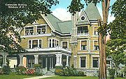
Hillsborough is part of School Administrative Unit (SAU) 34. Public schools serving the community of Hillsboro include:Sites of interest
- D.A.R.Daughters of the American RevolutionThe Daughters of the American Revolution is a lineage-based membership organization for women who are descended from a person involved in United States' independence....
Museum Room, in the Community Building - Franklin Pierce HomesteadFranklin Pierce HomesteadThe Franklin Pierce Homestead was the childhood home of the fourteenth President of the United States, Franklin Pierce. Located in Hillsborough, New Hampshire, the home was built in 1804 by Pierce's father, Benjamin Pierce. The home is one of Franklin Pierce's probable places of birth, the other...
http://www.nhstateparks.org/explore/state-parks/franklin-pierce-homestead.aspx (1804) - Fuller Public Library