

Timeline of the 1994 Atlantic hurricane season
Encyclopedia
1994 Atlantic hurricane season
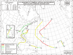
The 1994 Atlantic hurricane seasonofficially began June 1, 1994, and officially ended November 30, 1994. These dates conventionally delimit the period of each year when most tropical cyclones form in the Atlantic basin....
was a below-average Atlantic hurricane season
Atlantic hurricane season
The Atlantic hurricane season is the period in a year when hurricanes usually form in the Atlantic Ocean. Tropical cyclones in the North Atlantic are called hurricanes, tropical storms, or tropical depressions. In addition, there have been several storms over the years that have not been fully...
that produced seven named tropical cyclone
Tropical cyclone
A tropical cyclone is a storm system characterized by a large low-pressure center and numerous thunderstorms that produce strong winds and heavy rain. Tropical cyclones strengthen when water evaporated from the ocean is released as the saturated air rises, resulting in condensation of water vapor...
s. The season officially began on June 1 and ended on November 30, dates which conventionally limit the period of each year when tropical cyclones tend to form in the Atlantic. The first named storm, Tropical Storm Alberto
Tropical Storm Alberto (1994)
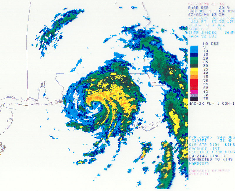
Tropical Storm Alberto was the first storm of the 1994 Atlantic hurricane season. It hit Florida across the Southeast United States in July, causing a massive flooding disaster while stalling over Georgia and Alabama. Alberto caused $1 billion in damage and 30 deaths.-Meteorological history:A...
, formed on June 30. The last storm of the season, Hurricane Gordon
Hurricane Gordon (1994)
Hurricane Gordon was a long-lived and erratic late-season hurricane of the 1994 Atlantic hurricane season. The twelfth and final tropical cyclone of the season, Gordon formed in the southwestern Caribbean on November 8 after two tropical waves enhanced convection around in area of disturbed...
, dissipated on November 21. This timeline documents tropical cyclone
Tropical cyclone
A tropical cyclone is a storm system characterized by a large low-pressure center and numerous thunderstorms that produce strong winds and heavy rain. Tropical cyclones strengthen when water evaporated from the ocean is released as the saturated air rises, resulting in condensation of water vapor...
formations, strengthening, weakening, landfalls
Landfall (meteorology)
Landfall is the event of a tropical cyclone or a waterspout coming onto land after being over water. When a waterspout makes landfall it is reclassified as a tornado, which can then cause damage inland...
, extratropical transitions, as well as dissipation during the season. The timeline also includes information which was not operationally released, such as post-storm reviews by the National Hurricane Center
National Hurricane Center
The National Hurricane Center , located at Florida International University in Miami, Florida, is the division of the National Weather Service responsible for tracking and predicting weather systems within the tropics between the Prime Meridian and the 140th meridian west poleward to the 30th...
.
This season produced seven named storms; three attained hurricane status, though none became a major hurricane
Tropical cyclone scales
Tropical systems are officially ranked on one of several tropical cyclone scales according to their maximum sustained winds and in what oceanic basin they are located...
, a storm that ranks as a Category 3 or higher on the Saffir-Simpson Hurricane Scale
Saffir-Simpson Hurricane Scale
The Saffir–Simpson Hurricane Scale , or the Saffir–Simpson Hurricane Wind Scale , classifies hurricanes — Western Hemisphere tropical cyclones that exceed the intensities of tropical depressions and tropical storms — into five categories distinguished by the intensities of their sustained winds...
. Tropical Storm Alberto produced significant rainfall and flooding in the Southeastern United States
Southeastern United States
The Southeastern United States, colloquially referred to as the Southeast, is the eastern portion of the Southern United States. It is one of the most populous regions in the United States of America....
, damaging or destroying over 18,000 homes, and inflicting $750 million (1994 USD) in damages. In August, Tropical Storm Beryl produced heavy rainfall in areas of Florida, Georgia, South Carolina, and North Carolina, with moderate to heavy rainfall throughout several other states. Beryl caused numerous injuries, many of which occurred from a tornado
Tornado
A tornado is a violent, dangerous, rotating column of air that is in contact with both the surface of the earth and a cumulonimbus cloud or, in rare cases, the base of a cumulus cloud. They are often referred to as a twister or a cyclone, although the word cyclone is used in meteorology in a wider...
associated with the tropical storm. Tropical Storm Debby killed nine people throughout its path in September. Hurricane Gordon in November caused damages from Costa Rica
Costa Rica
Costa Rica , officially the Republic of Costa Rica is a multilingual, multiethnic and multicultural country in Central America, bordered by Nicaragua to the north, Panama to the southeast, the Pacific Ocean to the west and the Caribbean Sea to the east....
to North Carolina
North Carolina
North Carolina is a state located in the southeastern United States. The state borders South Carolina and Georgia to the south, Tennessee to the west and Virginia to the north. North Carolina contains 100 counties. Its capital is Raleigh, and its largest city is Charlotte...
in its six landfalls; extreme flooding and mudslides from the storm caused about 1,122 fatalities in Haiti
Haiti
Haiti , officially the Republic of Haiti , is a Caribbean country. It occupies the western, smaller portion of the island of Hispaniola, in the Greater Antillean archipelago, which it shares with the Dominican Republic. Ayiti was the indigenous Taíno or Amerindian name for the island...
.
June
- The Atlantic hurricane season officially begins.
June 30
- 2 a.m. EDT (0600 UTCCoordinated Universal TimeCoordinated Universal Time is the primary time standard by which the world regulates clocks and time. It is one of several closely related successors to Greenwich Mean Time. Computer servers, online services and other entities that rely on having a universally accepted time use UTC for that purpose...
) – Tropical Depression One forms 45 miles (75 km)The figures for maximum sustained windMaximum sustained windThe maximum sustained winds associated with a tropical cyclone are a common indicator of the intensity of the storm. Within a mature tropical cyclone, they are found within the eyewall at a distance defined as the radius of maximum wind, or RMW. Unlike gusts, the value of these winds are...
s and position estimates are rounded to the nearest 5 units (knots, miles, or kilometers), following the convention used in the National Hurricane CenterNational Hurricane CenterThe National Hurricane Center , located at Florida International University in Miami, Florida, is the division of the National Weather Service responsible for tracking and predicting weather systems within the tropics between the Prime Meridian and the 140th meridian west poleward to the 30th...
's operational products for each storm. All other units are rounded to the nearest digit. southeast of GuaneGuaneGuane is a municipality and city in the Pinar del Río Province of Cuba.The municipality is divided into the barrios of Cabo de San Antonio y La Fe, Catalina, Cortés, Hato de Guane, Isabel Rubio , Juan Gómez, La Grifa, Las Martinas, Los Acostas, Manuel Lazo , Portales, Pueblo, Punta de la Sierra,...
, CubaCubaThe Republic of Cuba is an island nation in the Caribbean. The nation of Cuba consists of the main island of Cuba, the Isla de la Juventud, and several archipelagos. Havana is the largest city in Cuba and the country's capital. Santiago de Cuba is the second largest city...
.
July
July 1- 8 p.m. EDT (0000 UTC July 2) – Tropical Depression One strengthens into Tropical Storm AlbertoTropical Storm Alberto (1994)Tropical Storm Alberto was the first storm of the 1994 Atlantic hurricane season. It hit Florida across the Southeast United States in July, causing a massive flooding disaster while stalling over Georgia and Alabama. Alberto caused $1 billion in damage and 30 deaths.-Meteorological history:A...
.
July 3
- 11 a.m. EDT (1500 UTC) – Tropical Storm Alberto makes landfall near DestinDestin, FloridaDestin is a city located in Okaloosa County, Florida. It is a principal city of the Fort Walton Beach-Crestview-Destin, Florida Metropolitan Statistical Area.Located on Florida's Emerald Coast, Destin is known for its white beaches and emerald green waters...
, FloridaFloridaFlorida is a state in the southeastern United States, located on the nation's Atlantic and Gulf coasts. It is bordered to the west by the Gulf of Mexico, to the north by Alabama and Georgia and to the east by the Atlantic Ocean. With a population of 18,801,310 as measured by the 2010 census, it...
with winds of 65 mph (100 km/h). - 8 p.m. EDT (0000 UTC July 4) – Tropical Storm Alberto weakens to a tropical depression.
July 7
- 8 p.m. EDT (0000 UTC July 8) – Tropical Depression Alberto dissipates over central AlabamaAlabamaAlabama is a state located in the southeastern region of the United States. It is bordered by Tennessee to the north, Georgia to the east, Florida and the Gulf of Mexico to the south, and Mississippi to the west. Alabama ranks 30th in total land area and ranks second in the size of its inland...
.
July 20
- 2 a.m. EDT (0600 UTC) – Tropical Depression Two forms 75 mi (120 km) southeast of CharlestonCharleston, South CarolinaCharleston is the second largest city in the U.S. state of South Carolina. It was made the county seat of Charleston County in 1901 when Charleston County was founded. The city's original name was Charles Towne in 1670, and it moved to its present location from a location on the west bank of the...
, South CarolinaSouth CarolinaSouth Carolina is a state in the Deep South of the United States that borders Georgia to the south, North Carolina to the north, and the Atlantic Ocean to the east. Originally part of the Province of Carolina, the Province of South Carolina was one of the 13 colonies that declared independence...
. - 10 a.m. EDT (1400 UTC) – Tropical Depression Two makes landfall near GeorgetownGeorgetown, South CarolinaGeorgetown is the third oldest city in the U.S. state of South Carolina and the county seat of Georgetown County, in the Low Country. Located on Winyah Bay at the confluence of the Great Pee Dee River, Waccamaw River, and Sampit River, Georgetown is the second largest seaport in South Carolina,...
, South CarolinaSouth CarolinaSouth Carolina is a state in the Deep South of the United States that borders Georgia to the south, North Carolina to the north, and the Atlantic Ocean to the east. Originally part of the Province of Carolina, the Province of South Carolina was one of the 13 colonies that declared independence...
with winds of 35 mph (55 km/h).
July 21
- 8 a.m. EDT (1200 UTC) – Tropical Depression Two dissipates over southern North CarolinaNorth CarolinaNorth Carolina is a state located in the southeastern United States. The state borders South Carolina and Georgia to the south, Tennessee to the west and Virginia to the north. North Carolina contains 100 counties. Its capital is Raleigh, and its largest city is Charlotte...
.
August
August 14.jpg)
- 8 a.m. EDT (1200 UTC) – Tropical Depression Three forms 165 mi (265 km) southwest of TallahasseeTallahassee, FloridaTallahassee is the capital of the U.S. state of Florida. It is the county seat and only incorporated municipality in Leon County, and is the 128th largest city in the United States. Tallahassee became the capital of Florida, then the Florida Territory, in 1824. In 2010, the population recorded by...
, FloridaFloridaFlorida is a state in the southeastern United States, located on the nation's Atlantic and Gulf coasts. It is bordered to the west by the Gulf of Mexico, to the north by Alabama and Georgia and to the east by the Atlantic Ocean. With a population of 18,801,310 as measured by the 2010 census, it...
.
August 15
- 8 a.m. EDT (1200 UTC) – Tropical Depression Three strengthens into Tropical Storm BerylTropical Storm Beryl (1994)Tropical Storm Beryl, was the second named storm of the 1994 Atlantic hurricane season. Beryl originated north of Puerto Rico as an upper-level low pressure system, then passed over Florida, then entered the gulf where it became a tropical depression. The storm had advisories on it for five days;...
. - 8 p.m. EDT (0000 UTC August 16) – Tropical Storm Beryl makes landfall near Panama CityPanama City, Florida-Personal income:The median income for a household in the city was $31,572, and the median income for a family was $40,890. Males had a median income of $30,401 versus $21,431 for females. The per capita income for the city was $17,830...
, FloridaFloridaFlorida is a state in the southeastern United States, located on the nation's Atlantic and Gulf coasts. It is bordered to the west by the Gulf of Mexico, to the north by Alabama and Georgia and to the east by the Atlantic Ocean. With a population of 18,801,310 as measured by the 2010 census, it...
with winds of 60 mph (95 km/h).
August 16
- 8 a.m. EDT (1200 UTC) – Tropical Storm Beryl weakens to a tropical depression.
- 8 a.m. ASTUTC-4UTC−04-00 is an identifier for a time offset from UTC of −04.This offset is used in the Atlantic Standard Time Zone in Canada and the North American Eastern Time Zone during daylight saving time , in the Caribbean region this is considered as the Eastern Caribbean timezone...
(1200 UTC) – Tropical Depression Four forms 1,020 mi (1,640 km) south-southwest of Brava, Cape VerdeBrava, Cape VerdeBrava is an island in Cape Verde. It is the smallest inhabited island, but at the same time the greenest, of Cape Verde, in the Sotavento group. First settled in the 1540s, its population grew after Mount Fogo on neighbouring Fogo erupted in 1675...
. - 8 p.m. AST (0000 UTC August 17) – Tropical Depression Four strengthens into Tropical Storm Chris.
August 18
- 2 a.m. AST (0600 UTC) – Tropical Storm Chris strengthens into a hurricane.
August 19
- 2 a.m. EDT (0600 UTC) – Tropical Depression Beryl dissipates over ConnecticutConnecticutConnecticut is a state in the New England region of the northeastern United States. It is bordered by Rhode Island to the east, Massachusetts to the north, and the state of New York to the west and the south .Connecticut is named for the Connecticut River, the major U.S. river that approximately...
as it is absorbed by a frontalWeather frontA weather front is a boundary separating two masses of air of different densities, and is the principal cause of meteorological phenomena. In surface weather analyses, fronts are depicted using various colored lines and symbols, depending on the type of front...
troughTrough (meteorology)A trough is an elongated region of relatively low atmospheric pressure, often associated with fronts.Unlike fronts, there is not a universal symbol for a trough on a weather chart. The weather charts in some countries or regions mark troughs by a line. In the United States, a trough may be marked...
. - 8 a.m. EDT (1200 UTC) – Hurricane Chris reaches its peak intensity with winds of 80 mph (140 km/h) while located 570 mi (920 km) west-northwest of BarbudaBarbudaBarbuda is an island in the Eastern Caribbean, and forms part of the state of Antigua and Barbuda. It has a population of about 1,500, most of whom live in the town of Codrington.-Location:...
.
August 20
- 2 a.m. EDT (0600 UTC) – Hurricane Chris weakens to a tropical storm.
August 23
.jpg)
- 8 p.m. EDT (0000 UTC August 24) – Tropical Storm Chris dissipates as it is merges with an extratropical cycloneExtratropical cycloneExtratropical cyclones, sometimes called mid-latitude cyclones or wave cyclones, are a group of cyclones defined as synoptic scale low pressure weather systems that occur in the middle latitudes of the Earth having neither tropical nor polar characteristics, and are connected with fronts and...
southeast of Newfoundland.
August 29
- 7 a.m. CDT (1200 UTC) – Tropical Depression Five forms 220 mi (355 km) northeast of Veracruz, MexicoVeracruz, VeracruzVeracruz, officially known as Heroica Veracruz, is a major port city and municipality on the Gulf of Mexico in the Mexican state of Veracruz. The city is located in the central part of the state. It is located along Federal Highway 140 from the state capital Xalapa, and is the state's most...
.
August 31
- 1 a.m. CDT (0600 UTC) – Tropical Depression Five makes landfall near Tampico, Mexico with winds of 35 mph (55 km/h).
- 1 p.m. CDT (1800 UTC) – Tropical Depression Five dissipates over the mountains of Mexico.
September
September 9- 8 a.m. AST (1200 UTC) – Tropical Depression Six forms 175 mi (285 km) west of BarbadosBarbadosBarbados is an island country in the Lesser Antilles. It is in length and as much as in width, amounting to . It is situated in the western area of the North Atlantic and 100 kilometres east of the Windward Islands and the Caribbean Sea; therein, it is about east of the islands of Saint...
. - 8 p.m. AST (0000 UTC) – Tropical Depression Six strengthens into Tropical Storm DebbyTropical Storm Debby (1994)Tropical Storm Debby, was the fourth named storm of the 1994 Atlantic hurricane season. Debby lasted only two days, reaching peak winds of 70 mph before being sheared apart on September 11...
. - 11 p.m. AST (0300 UTC) – Tropical Storm Debby passes over the island of St. Lucia with winds of 65 mph (100 km/h).
September 11
.jpg)
- 2 a.m. AST (0600 UTC) – Tropical Storm Debby degenerates into a tropical waveTropical waveTropical waves, easterly waves, or tropical easterly waves, also known as African easterly waves in the Atlantic region, are a type of atmospheric trough, an elongated area of relatively low air pressure, oriented north to south, which move from east to west across the tropics causing areas of...
in the eastern Caribbean SeaCaribbean SeaThe Caribbean Sea is a sea of the Atlantic Ocean located in the tropics of the Western hemisphere. It is bounded by Mexico and Central America to the west and southwest, to the north by the Greater Antilles, and to the east by the Lesser Antilles....
.
September 21
- 2 p.m. AST (1800 UTC) – Tropical Depression Seven forms 470 mi (760 km) southwest of Brava, Cape Verde.'
September 22
- 8 a.m. AST (1200 UTC) – Tropical Depression Seven strengthens into Tropical Storm Ernesto.
September 24
- 8 a.m. AST (1200 UTC) – Tropical Storm Ernesto weakens to a tropical depression.
- 8 a.m. EDT (1200 UTC) – Tropical Depression Eight forms 10 mi (15 km) north of the HondurasHondurasHonduras is a republic in Central America. It was previously known as Spanish Honduras to differentiate it from British Honduras, which became the modern-day state of Belize...
coastline.
September 25
- 2 p.m. EDT (1800 UTC) – Tropical Depression Eight makes landfall in southern BelizeBelizeBelize is a constitutional monarchy and the northernmost country in Central America. Belize has a diverse society, comprising many cultures and languages. Even though Kriol and Spanish are spoken among the population, Belize is the only country in Central America where English is the official...
with winds of 35 mph (55 km/h). - 8 p.m. AST (0000 UTC September 26) – Tropical Depression Ernesto dissipates over open waters.
September 26
- 2 p.m. EDT (1800 UTC) – Tropical Depression Eight dissipates over eastern GuatemalaGuatemalaGuatemala is a country in Central America bordered by Mexico to the north and west, the Pacific Ocean to the southwest, Belize to the northeast, the Caribbean to the east, and Honduras and El Salvador to the southeast...
.
September 27
- 8 a.m. AST (1200 UTC) – Tropical Depression Nine forms 200 mi (320 km) southeast of Praia, Cape VerdePraiaPraia , is the capital and largest city of Cape Verde, an island nation in the Atlantic Ocean west of Senegal. It lies on the southern coast of Santiago island in the Sotavento Islands group. It is the island's ferry port and is home to one of the nation’s four international airports...
.
September 28
- 8 p.m. AST (0000 UTC September 29) – Tropical Depression Nine dissipates near Sal, Cape VerdeSal, Cape VerdeSal is an island in Cape Verde. It belongs to the northern group of islands, called Barlavento. The island is composed by a single administrative division, the Sal municipality. The island is home to Amílcar Cabral International Airport, the main airport of Cape Verde.- Geography :The island is...
.
September 29
.jpg)
- 2 a.m. EDT (0600 UTC) – Tropical Depression Ten forms 50 mi (85 km) east of Cozumel, MexicoCozumelCozumel is an island in the Caribbean Sea off the eastern coast of Mexico's Yucatan Peninsula, opposite Playa del Carmen, and close to the Yucatan Channel. Cozumel is one of the ten municipalities of the state of Quintana Roo...
. - 8 p.m. EDT (0000 UTC September 30) - Tropical Depression Ten enters the Gulf of MexicoGulf of MexicoThe Gulf of Mexico is a partially landlocked ocean basin largely surrounded by the North American continent and the island of Cuba. It is bounded on the northeast, north and northwest by the Gulf Coast of the United States, on the southwest and south by Mexico, and on the southeast by Cuba. In...
.
September 30
- 2 p.m. EDT (1800 UTC) – Tropical Depression Ten dissipates over open waters.
November
November 1- 8 p.m. AST (0000 UTC November 2) – A subtropical depressionSubtropical cycloneA subtropical cyclone is a weather system that has some characteristics of a tropical and an extratropical cyclone. As early as the 1950s, meteorologists were unclear whether they should be characterized as tropical or extratropical cyclones. They were officially recognized by the National...
forms 1,020 mi (1,640 km) northeast of Barbuda.
November 2
- 2 a.m. AST (0600 UTC) – The subtropical depression strengthens into a subtropical storm.
November 3
- 2 a.m. AST (0600 UTC) – The subtropical storm weakens to a subtropical depression.
- 2 p.m. AST (1800 UTC) – The subtropical depression gains enough tropical characteristics to be declared Tropical Depression Eleven.
- 8 p.m. AST (0000 UTC November 4) – Tropical Depression Eleven strengthens into Tropical Storm FlorenceHurricane Florence (1994)Hurricane Florence was a strong, late season hurricane that remained out over the open waters of the Central Atlantic for nearly a week, before being absorbed into a large extratropical cyclone. With peak winds of 110 mph and a minimum pressure of 972 mbar , Florence was the strongest...
.
November 4
- 2 p.m. AST (1800 UTC) – Tropical Storm Florence strengthens into a hurricane.
November 7
.jpg)
- 2 p.m. AST (1800 UTC) – Hurricane Florence strengthens into a Category 2 hurricane.
- 8 p.m. AST (0000 UTC November 8) – Hurricane Florence reaches its peak intensity with winds of 110 mph (175 km/h) while located 900 mi (1,445 km) northeast of BermudaBermudaBermuda is a British overseas territory in the North Atlantic Ocean. Located off the east coast of the United States, its nearest landmass is Cape Hatteras, North Carolina, about to the west-northwest. It is about south of Halifax, Nova Scotia, Canada, and northeast of Miami, Florida...
.
November 8
- 8 a.m. EDT (1200 UTC) – Tropical Depression Twelve forms 100 mi (160 km) east of Bluefields, NicaraguaBluefieldsBluefields is the capital of the municipality of the same name, and of Región Autónoma del Atlántico Sur in Nicaragua. It was also capital of the former Zelaya Department, which was divided into North and South Atlantic Autonomous Regions...
. - 2 p.m. AST (1800 UTC) – Hurricane Florence weakens to a Category 1 hurricane.
- 8 p.m. AST (0000 UTC November 9) – Hurricane Florence dissipates as it is absorbed by an extratropical cyclone.
November 10
- 2 a.m. EDT (0600 UTC) – Tropical Depression Twelve makes landfall near Puerto Cabezas, NicaraguaPuerto CabezasPuerto Cabezas is a municipality in, and capital of, the North Atlantic Coast department of Nicaragua....
with winds of 35 mph (55 km/h). - 2 p.m. EDT (1800 UTC) – Tropical Depression Twelve strengthens into Tropical Storm GordonHurricane Gordon (1994)Hurricane Gordon was a long-lived and erratic late-season hurricane of the 1994 Atlantic hurricane season. The twelfth and final tropical cyclone of the season, Gordon formed in the southwestern Caribbean on November 8 after two tropical waves enhanced convection around in area of disturbed...
.
November 12
- 11 p.m. EDT (0300 UTC November 13) – Tropical Storm Gordon makes landfall near Kingston, JamaicaKingston, JamaicaKingston is the capital and largest city of Jamaica, located on the southeastern coast of the island. It faces a natural harbour protected by the Palisadoes, a long sand spit which connects the town of Port Royal and the Norman Manley International Airport to the rest of the island...
with winds of 40 mph (65 km/h).
November 13
- 9 a.m. EDT (1300 UTC) – Tropical Storm Gordon makes landfall near Guantánamo Bay, Cuba with winds of 45 mph (75 km/h).
November 15
- 9 a.m. EDT (1300 UTC) – Tropical Storm Gordon makes landfall near Key WestKey West, FloridaKey West is a city in Monroe County, Florida, United States. The city encompasses the island of Key West, the part of Stock Island north of U.S. 1 , Sigsbee Park , Fleming Key , and Sunset Key...
, FloridaFloridaFlorida is a state in the southeastern United States, located on the nation's Atlantic and Gulf coasts. It is bordered to the west by the Gulf of Mexico, to the north by Alabama and Georgia and to the east by the Atlantic Ocean. With a population of 18,801,310 as measured by the 2010 census, it...
with winds of 50 mph (85 km/h).
November 16
- 9 a.m. EDT (1300 UTC) – Tropical Storm Gordon makes landfall near Fort MyersFort Myers, FloridaFort Myers is the county seat and commercial center of Lee County, Florida, United States. Its population was 62,298 in the 2010 census, a 29.23 percent increase over the 2000 figure....
, FloridaFloridaFlorida is a state in the southeastern United States, located on the nation's Atlantic and Gulf coasts. It is bordered to the west by the Gulf of Mexico, to the north by Alabama and Georgia and to the east by the Atlantic Ocean. With a population of 18,801,310 as measured by the 2010 census, it...
with winds of 50 mph (85 km/h).
November 17

- 2 p.m. EDT (1800 UTC) – Tropical Storm Gordon strengthens into a hurricane.
- 8 p.m. EDT (0000 UTC November 18) – Hurricane Gordon reaches its peak intensity with winds of 85 mph (140 km/h) while located 225 mi (365 km) southeast of WilmingtonWilmington, North CarolinaWilmington is a port city in and is the county seat of New Hanover County, North Carolina, United States. The population is 106,476 according to the 2010 Census, making it the eighth most populous city in the state of North Carolina...
, North CarolinaNorth CarolinaNorth Carolina is a state located in the southeastern United States. The state borders South Carolina and Georgia to the south, Tennessee to the west and Virginia to the north. North Carolina contains 100 counties. Its capital is Raleigh, and its largest city is Charlotte...
.
November 18
- 2 p.m. EDT (1800 UTC) – Hurricane Gordon weakens to a tropical storm.
November 20
- 2 a.m. EDT (0600 UTC) – Tropical Storm Gordon weakens to a tropical depression.
- 11 p.m. EDT (0300 UTC) – Tropical Depression Gordon makes landfall near Cape CanaveralCape CanaveralCape Canaveral, from the Spanish Cabo Cañaveral, is a headland in Brevard County, Florida, United States, near the center of the state's Atlantic coast. Known as Cape Kennedy from 1963 to 1973, it lies east of Merritt Island, separated from it by the Banana River.It is part of a region known as the...
, FloridaFloridaFlorida is a state in the southeastern United States, located on the nation's Atlantic and Gulf coasts. It is bordered to the west by the Gulf of Mexico, to the north by Alabama and Georgia and to the east by the Atlantic Ocean. With a population of 18,801,310 as measured by the 2010 census, it...
with winds of 30 mph (45 km/h).
November 21
- 8 p.m. EDT (0000 UTC November 22) – Tropical Depression Gordon dissipates over South CarolinaSouth CarolinaSouth Carolina is a state in the Deep South of the United States that borders Georgia to the south, North Carolina to the north, and the Atlantic Ocean to the east. Originally part of the Province of Carolina, the Province of South Carolina was one of the 13 colonies that declared independence...
.
November 30
- The Atlantic hurricane season officially ends.