

Timeline of the 2007 Atlantic hurricane season
Encyclopedia
Landfall (meteorology)
Landfall is the event of a tropical cyclone or a waterspout coming onto land after being over water. When a waterspout makes landfall it is reclassified as a tornado, which can then cause damage inland...
, extratropical transitions, as well as dissipation during the 2007 Atlantic hurricane season
2007 Atlantic hurricane season
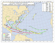
The 2007 Atlantic hurricane season was an active Atlantic hurricane season that produced 17 tropical cyclones, 15 tropical storms, six hurricanes, and two major hurricanes. It officially started on June 1 and ended on November 30, dates which conventionally delimit the...
. The season officially began on June 1, 2007, and ended on November 30, although Subtropical Storm Andrea and Tropical Storm Olga formed outside the official parameters, on May 9 and December 11, respectively. The timeline also includes information which was not operationally released, meaning that information from post-storm reviews by the National Hurricane Center
National Hurricane Center
The National Hurricane Center , located at Florida International University in Miami, Florida, is the division of the National Weather Service responsible for tracking and predicting weather systems within the tropics between the Prime Meridian and the 140th meridian west poleward to the 30th...
, such as information on a storm that was not operationally warned on, have been included.
During the year, a total of 17 tropical cyclones, 15 tropical storms, six hurricanes and two major hurricanes formed. The most intense hurricane, Dean
Hurricane Dean
The name Dean was used for five tropical cyclones in the Northern Atlantic Ocean:*1983's Tropical Storm Dean, which struck the coast of Virginia, causing minor erosion and flooding...
, tied for the seventh most intense Atlantic hurricane ever recorded as well as the third most intense Atlantic hurricane at landfall. The season was one of only four on record for the Atlantic
Atlantic Ocean
The Atlantic Ocean is the second-largest of the world's oceanic divisions. With a total area of about , it covers approximately 20% of the Earth's surface and about 26% of its water surface area...
with more than one Category 5 storm. It was the second on record in which an Atlantic hurricane, Felix
Hurricane Felix
The name Felix was used for four tropical cyclones in the Atlantic Ocean.* 1989's Hurricane Felix - A Category 1 storm that dissipated in the Atlantic without threatening land....
, and an eastern Pacific hurricane, Henriette
Hurricane Henriette (2007)
Hurricane Henriette was the deadliest tropical cyclone of the 2007 Pacific hurricane season. The storm, which caused nine fatalities, formed from an area of disturbed weather on August 30, 2007, and became a tropical storm the next day. The cyclone moved parallel to the Mexican Pacific coast, but...
, made landfall on the same day. September had a record-tying eight storms, although the strengths and durations of most of the storms were low. Aside from Dean and Felix, none of the storms exceeded Category 1 intensity.
May
May 9
- 2 a.m. EDTNorth American Eastern Time ZoneThe Eastern Time Zone of the United States and Canada is a time zone that falls mostly along the east coast of North America. Its UTC time offset is −5 hrs during standard time and −4 hrs during daylight saving time...
(0600 UTCCoordinated Universal TimeCoordinated Universal Time is the primary time standard by which the world regulates clocks and time. It is one of several closely related successors to Greenwich Mean Time. Computer servers, online services and other entities that rely on having a universally accepted time use UTC for that purpose...
) – Subtropical Storm AndreaSubtropical Storm Andrea (2007)Subtropical Storm Andrea was the first named storm and first subtropical cyclone of the 2007 Atlantic hurricane season. It developed out of a previously non-tropical low on May 9 about 150 miles northeast of Daytona Beach, Florida, three weeks before the official start of the season...
forms 150 nautical miles (280 km, 175 miles) east of Jacksonville, FloridaJacksonville, FloridaJacksonville is the largest city in the U.S. state of Florida in terms of both population and land area, and the largest city by area in the contiguous United States. It is the county seat of Duval County, with which the city government consolidated in 1968...
.
May 10
- 8 a.m. EDT (1200 UTC) – Subtropical Storm Andrea weakens into a subtropical depression.
May 11
- 2 a.m. EDTNorth American Eastern Time ZoneThe Eastern Time Zone of the United States and Canada is a time zone that falls mostly along the east coast of North America. Its UTC time offset is −5 hrs during standard time and −4 hrs during daylight saving time...
(0600 UTC May 11) – Subtropical Depression Andrea degenerates into a remnant low.
June
June 1- 12 a.m. EDT (0400 UTC) – The 2007 Atlantic hurricane season2007 Atlantic hurricane seasonThe 2007 Atlantic hurricane season was an active Atlantic hurricane season that produced 17 tropical cyclones, 15 tropical storms, six hurricanes, and two major hurricanes. It officially started on June 1 and ended on November 30, dates which conventionally delimit the...
officially begins. - 8 a.m. EDT (1200 UTC) – A tropical depression forms just northwest of the western tip of CubaCubaThe Republic of Cuba is an island nation in the Caribbean. The nation of Cuba consists of the main island of Cuba, the Isla de la Juventud, and several archipelagos. Havana is the largest city in Cuba and the country's capital. Santiago de Cuba is the second largest city...
. - 2 p.m. EDT (1800 UTC) – The tropical depression near Cuba strengthens into Tropical Storm BarryTropical Storm Barry (2007)Tropical Storm Barry was a rapidly-forming tropical cyclone that made landfall on Florida, United States, in early June 2007. The second named storm of the 2007 Atlantic hurricane season, Barry developed from a trough of low pressure in the southeastern Gulf of Mexico on June 1...
.
June 2
- 10 a.m. EDT (1400 UTC) – Tropical Storm Barry weakens into a tropical depression as it makes landfall near Tampa BayTampa BayTampa Bay is a large natural harbor and estuary along the Gulf of Mexico on the west central coast of Florida, comprising Hillsborough Bay, Old Tampa Bay, Middle Tampa Bay, and Lower Tampa Bay."Tampa Bay" is not the name of any municipality...
with 35 mph (55 km/h) winds. - 8 p.m. EDT (0000 UTC June 3) – Tropical Depression Barry becomes extratropical.
July
July 30- 8 p.m. EDT (0000 UTC July 31) – Tropical Depression Three forms 270 miles (434.5 km) north-northwest of BermudaBermudaBermuda is a British overseas territory in the North Atlantic Ocean. Located off the east coast of the United States, its nearest landmass is Cape Hatteras, North Carolina, about to the west-northwest. It is about south of Halifax, Nova Scotia, Canada, and northeast of Miami, Florida...
.
July 31
- 2 a.m. EDT (0600 UTC) – Tropical Depression Three is upgraded to Tropical Storm Chantal.
August
August 1- 2 a.m. EDT (0600 UTC) – Tropical Storm Chantal becomes extratropical.
August 13
- 2 a.m. EDT (0600 UTC) – Tropical Depression Four forms 520 miles (836.9 km) west-southwest of the southernmost Cape VerdeCape VerdeThe Republic of Cape Verde is an island country, spanning an archipelago of 10 islands located in the central Atlantic Ocean, 570 kilometres off the coast of Western Africa...
islands.
August 14
- 8 a.m. ASTUTC-4UTC−04-00 is an identifier for a time offset from UTC of −04.This offset is used in the Atlantic Standard Time Zone in Canada and the North American Eastern Time Zone during daylight saving time , in the Caribbean region this is considered as the Eastern Caribbean timezone...
(1200 UTC) – Tropical Depression Four is upgraded to Tropical Storm Dean. - 7 p.m. CDT (0000 UTC August 15) – Tropical Depression Five forms in Central Gulf of MexicoGulf of MexicoThe Gulf of Mexico is a partially landlocked ocean basin largely surrounded by the North American continent and the island of Cuba. It is bounded on the northeast, north and northwest by the Gulf Coast of the United States, on the southwest and south by Mexico, and on the southeast by Cuba. In...
.
August 15
- 1 p.m. CDT (1800 UTC) – Tropical Depression Five is upgraded to Tropical Storm Erin.
August 16
- 2 a.m. AST (0600 UTC) – Tropical Storm Dean is upgraded to Hurricane DeanHurricane DeanThe name Dean was used for five tropical cyclones in the Northern Atlantic Ocean:*1983's Tropical Storm Dean, which struck the coast of Virginia, causing minor erosion and flooding...
. - 5:30 a.m. CDT (1030 UTC) – Tropical Storm Erin makes landfall near San José Island, TexasTexasTexas is the second largest U.S. state by both area and population, and the largest state by area in the contiguous United States.The name, based on the Caddo word "Tejas" meaning "friends" or "allies", was applied by the Spanish to the Caddo themselves and to the region of their settlement in...
with 35 mph (65 km/h).The figures for maximum sustained windMaximum sustained windThe maximum sustained winds associated with a tropical cyclone are a common indicator of the intensity of the storm. Within a mature tropical cyclone, they are found within the eyewall at a distance defined as the radius of maximum wind, or RMW. Unlike gusts, the value of these winds are...
s and position estimates are rounded to the nearest 5 units (knots, miles, or kilometers), following the convention used in the National Hurricane CenterNational Hurricane CenterThe National Hurricane Center , located at Florida International University in Miami, Florida, is the division of the National Weather Service responsible for tracking and predicting weather systems within the tropics between the Prime Meridian and the 140th meridian west poleward to the 30th...
's operational products for each storm. All other units are rounded to the nearest digit. - 7 a.m. CDT (1200 UTC) – Tropical Storm Erin is downgraded to a tropical depression.
- 8 a.m. AST (1200 UTC) – Hurricane Dean is upgraded to a Category 2 hurricane.
August 17
- 7 a.m. CDT (1200 UTC) – Tropical Depression Erin is downgraded to a remnant low about 50 nautical miles south of San AngeloSan Angelo, TexasSan Angelo is a city in the state of Texas. Located in West Central Texas it is the county seat of Tom Green County. As of 2010 according to the United States Census Bureau, the city had a total population of 93,200...
, TexasTexasTexas is the second largest U.S. state by both area and population, and the largest state by area in the contiguous United States.The name, based on the Caddo word "Tejas" meaning "friends" or "allies", was applied by the Spanish to the Caddo themselves and to the region of their settlement in...
. - 2 p.m. EDT (1800 UTC) – Hurricane Dean is upgraded to a Category 3 hurricane, becoming the first major hurricane of the season.
- 8 p.m. EDT (0000 UTC August 18) – Hurricane Dean is upgraded to a Category 4 hurricane.
August 18
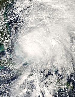
- 2 a.m. EDT (0600 UTC) – Hurricane Dean is upgraded to a Category 5 hurricane.
- 2 p.m. EDT (1800 UTC) – Hurricane Dean is downgraded to a Category 4 hurricane.
August 20
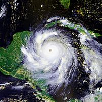
- 8 p.m. EDT (0000 UTC August 21) - Hurricane Dean is re-upgraded to a Category 5 hurricane.
August 21
- 3:30 a.m. CDT (0830 UTC) – Hurricane Dean makes landfall near MajahualCosta MayaCosta Maya is a small tourist region in the municipality of Othón P. Blanco in the state of Quintana Roo, Mexico, the only state with Caribbean Sea. This municipality is close to Chetumal on the border with Belize, until recently British Honduras...
, MexicoMexicoThe United Mexican States , commonly known as Mexico , is a federal constitutional republic in North America. It is bordered on the north by the United States; on the south and west by the Pacific Ocean; on the southeast by Guatemala, Belize, and the Caribbean Sea; and on the east by the Gulf of...
with 175 mph (280 km/h) winds.
August 22
- c. 11:30 a.m. CDT (1630 UTC) – Hurricane Dean is again upgraded to a Category 2 hurricane.
- 11:30 a.m. CDT (1630 UTC) – Hurricane Dean makes its second landfall, near Tecolutla, VeracruzTecolutla, VeracruzTecolutla is a town and municipality on the eastern coast of the state of Veracruz in Mexico. It is the closest beach to Mexico City and much of its economy is based on attracting people from this city, as it is only a four or five-hour drive. It is also the northern end of a tourist corridor...
with 100 mph (160 km/h) winds.
- 7 p.m. CDT (0000 UTC August 23) – Hurricane Dean is downgraded to a tropical depression inland over Mexico.
August 23
- 1 a.m. CDT (0600 UTC) – Tropical Depression Dean dissipates inland over Mexico.
August 31
- 8 a.m. AST (1200 UTCCoordinated Universal TimeCoordinated Universal Time is the primary time standard by which the world regulates clocks and time. It is one of several closely related successors to Greenwich Mean Time. Computer servers, online services and other entities that rely on having a universally accepted time use UTC for that purpose...
) – Tropical Depression Six forms east of the Windward IslandsWindward IslandsThe Windward Islands are the southern islands of the Lesser Antilles, within the West Indies.-Name and geography:The Windward Islands are called such because they were more windward to sailing ships arriving in the New World than the Leeward Islands, given that the prevailing trade winds in the...
. - 8 p.m. AST (0000 UTC September 1) – Tropical Depression Six is upgraded to Tropical Storm Felix.
September
September 1- 4:45 a.m. AST (0845 UTC) – Tropical Storm Felix makes landfall on GrenadaGrenadaGrenada is an island country and Commonwealth Realm consisting of the island of Grenada and six smaller islands at the southern end of the Grenadines in the southeastern Caribbean Sea...
with 50 mph (85 km/h) winds. - 8 p.m. AST (0000 UTC September 2) – Tropical Storm Felix is upgraded to Hurricane Felix.
September 2
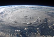
- 2 a.m. AST (0600 UTC) – Hurricane Felix is upgraded to a Category 2 hurricane.
- 2 p.m. AST (1800 UTC) – Hurricane Felix is upgraded to a Category 4 hurricane.
September 3
- 2 a.m. AST (0600 UTC) – Hurricane Felix is upgraded to the second Category 5 hurricane of the season.
September 4
- 8 a.m. EDT (1200 UTC) – Hurricane Felix makes landfall near Punta Gorda, NicaraguaNicaraguaNicaragua is the largest country in the Central American American isthmus, bordered by Honduras to the north and Costa Rica to the south. The country is situated between 11 and 14 degrees north of the Equator in the Northern Hemisphere, which places it entirely within the tropics. The Pacific Ocean...
with 160 mph (260 km/h) winds. - 8 p.m. AST (0000 UTC September 5) – Hurricane Felix is downgraded to a tropical storm.
September 5
- 2 a.m. CDT (0600 UTC) – Tropical Storm Felix is downgraded to a tropical depression.
- 8 a.m. CDT (1200 UTC) – Tropical Depression Felix is downgraded to a remnant low.
September 7
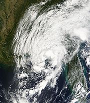
- 8 p.m. EDT (0000 UTC September 8) – Subtropical Storm Gabrielle forms 385 mi (619.6 km) South-East of Cape Lookout, North Carolina.
September 8
- 2 p.m. EDT (1800 UTC) – Subtropical Storm Gabrielle becomes Tropical Storm GabrielleTropical Storm Gabrielle (2007)Tropical Storm Gabrielle was a short-lived tropical cyclone that passed over North Carolina before tracking out to sea. The seventh named storm of the 2007 Atlantic hurricane season, Gabrielle developed as a subtropical cyclone on September 8 about 385 miles southeast of Cape Lookout, North...
.
September 9
- 11:30 a.m. EDT (1530 UTC) – Tropical Storm Gabrielle makes landfall near the Cape Lookout National SeashoreCape Lookout National SeashoreCape Lookout National Seashore preserves a 56-mile long section of the Southern Outer Banks, or Crystal Coast, of North Carolina, USA, running from Ocracoke Inlet on the northeast to Beaufort Inlet on the southeast. Three undeveloped barrier islands make up the seashore - North Core Banks, South...
with 60 mph (95 km/h) winds.
September 10
- 2 a.m. EDT (0600 UTC) – Tropical Storm Gabrielle is downgraded to a tropical depression.
September 11
- 8 a.m. EDT (1200 UTC) – Tropical Depression Gabrielle dissipates.
September 12
- 8 a.m. EDT (1200 UTCCoordinated Universal TimeCoordinated Universal Time is the primary time standard by which the world regulates clocks and time. It is one of several closely related successors to Greenwich Mean Time. Computer servers, online services and other entities that rely on having a universally accepted time use UTC for that purpose...
) – Tropical Depression Eight forms east of the Lesser AntillesLesser AntillesThe Lesser Antilles are a long, partly volcanic island arc in the Western Hemisphere. Most of its islands form the eastern boundary of the Caribbean Sea with the Atlantic Ocean, with the remainder located in the southern Caribbean just north of South America...
. - 8 a.m. EDT (1200 UTCCoordinated Universal TimeCoordinated Universal Time is the primary time standard by which the world regulates clocks and time. It is one of several closely related successors to Greenwich Mean Time. Computer servers, online services and other entities that rely on having a universally accepted time use UTC for that purpose...
) – Tropical Storm Humberto forms in the Gulf of MexicoGulf of MexicoThe Gulf of Mexico is a partially landlocked ocean basin largely surrounded by the North American continent and the island of Cuba. It is bounded on the northeast, north and northwest by the Gulf Coast of the United States, on the southwest and south by Mexico, and on the southeast by Cuba. In...
, southeast of Houston, TexasHouston, TexasHouston is the fourth-largest city in the United States, and the largest city in the state of Texas. According to the 2010 U.S. Census, the city had a population of 2.1 million people within an area of . Houston is the seat of Harris County and the economic center of , which is the ...
.
September 13
- 1 a.m. CDT (0600 UTC) – Tropical Storm Humberto is upgraded to Hurricane Humberto.
- 2 a.m. AST (0600 UTC) – Tropical Depression Eight is upgraded to Tropical Storm Ingrid.
- 2 a.m. CDT (0700 UTC) – Hurricane Humberto makes landfall just east of High Island, TexasHigh Island, TexasHigh Island is an unincorporated area located in the Bolivar Peninsula census-designated place, Galveston County, Texas, United States. The community is located in the extreme eastern part of the county on Bolivar Peninsula, less than one mile from Chambers County and less than two miles from...
with 90 mph (150 km/h) winds. - 1 a.m. CDT (1800 UTC) – Hurricane Humberto is downgraded to a tropical storm.
- 7 p.m. CDT (0000 UTC September 14) – Tropical Storm Humberto is downgraded to a tropical depression.
September 14
- 7 p.m. CDT (0600 UTC) – Tropical Depression Humberto is downgraded to a low.
September 15
- 2 p.m. AST (1800 UTC) – Tropical Storm Ingrid is downgraded to a tropical depression.
September 17
- 2 a.m. AST (0600 UTC) – Tropical Depression Ingrid is downgraded to a remnant low.
September 21
- 7 a.m. CDT (1200 UTC) – Subtropical Depression Ten forms in the Gulf of MexicoGulf of MexicoThe Gulf of Mexico is a partially landlocked ocean basin largely surrounded by the North American continent and the island of Cuba. It is bounded on the northeast, north and northwest by the Gulf Coast of the United States, on the southwest and south by Mexico, and on the southeast by Cuba. In...
, south of the Florida PanhandleFlorida PanhandleThe Florida Panhandle, an informal, unofficial term for the northwestern part of Florida, is a strip of land roughly 200 miles long and 50 to 100 miles wide , lying between Alabama on the north and the west, Georgia also on the north, and the Gulf of Mexico to the south. Its eastern boundary is...
. - 1 p.m. CDT (1800 UTC) – Subtropical Depression Ten is reclassified as Tropical Depression TenTropical Depression Ten (2007)Tropical Depression Ten was a short-lived tropical cyclone that made landfall on the Florida Panhandle in September 2007. The system developed as a subtropical depression on September 21 in the northeastern Gulf of Mexico from the interaction of a tropical wave, the tail end of a cold front, and an...
. - 7 p.m. CDT (0000 UTC September 22) – Tropical Depression Ten makes landfall near Fort Walton Beach, FloridaFort Walton Beach, FloridaFort Walton Beach is a city in southern Okaloosa County, Florida, United States. As of 2005, the population estimate for Fort Walton Beach was 19,992, and as of 2010, the population estimate for Fort Walton Beach is 19,507 recorded by the U.S. Census Bureau...
with 30 mph (45 km/h) winds.
September 22
- 1 a.m. CDT (0600 UTC) – Tropical Depression Ten degenerates to a remnant low.
- 7 p.m. CDT (0000 UTC September 23) – Subtropical Depression Eleven forms in the open Atlantic Ocean.
September 23
- 1 a.m. CDT (0600 UTC) – Subtropical Depression Eleven is upgraded to Subtropical Storm Jerry.
- 8 p.m. AST (0000 UTC September 24) – Subtropical Storm Jerry is reclassified as Tropical Storm Jerry.
September 24
- 2 p.m. AST (1800 UTC) – Tropical Storm Jerry is downgraded to a tropical depression.
- 8 p.m. AST (0000 UTC September 25) – Tropical Depression Jerry dissipates.
- 8 p.m. AST (0000 UTC September 25) – Tropical Depression Twelve forms east of the southern Windward IslandsWindward IslandsThe Windward Islands are the southern islands of the Lesser Antilles, within the West Indies.-Name and geography:The Windward Islands are called such because they were more windward to sailing ships arriving in the New World than the Leeward Islands, given that the prevailing trade winds in the...
.
September 25
- 2 a.m. AST (0600 UTC) – Tropical Depression Twelve is upgraded to Tropical Storm Karen.
- 1 p.m. CDT (1800 UTC) – Tropical Depression Thirteen forms east of TampicoTampicoTampico is a city and port in the state of Tamaulipas, in the country of Mexico. It is located in the southeastern part of the state, directly north across the border from Veracruz. Tampico is the third largest city in Tamaulipas, and counts with a population of 309,003. The Metropolitan area of...
in the southern Gulf of Mexico.
September 26
- 8 a.m. AST (1200 UTC) – Tropical Storm Karen strengthens into Hurricane Karen.
- 8 p.m. AST (0000 UTC September 27) – Hurricane Karen weakens to a tropical storm.
September 27
- 7 a.m. CDT (1200 UTC) – Tropical Depression Thirteen is upgraded to Tropical Storm Lorenzo.
- 7 p.m. CDT (0000 UTC September 28) – Tropical Storm Lorenzo is upgraded to Hurricane Lorenzo.
September 28
- 12 a.m. CDT (0500 UTC) – Hurricane Lorenzo makes landfall Tecolutla, VeracruzTecolutla, VeracruzTecolutla is a town and municipality on the eastern coast of the state of Veracruz in Mexico. It is the closest beach to Mexico City and much of its economy is based on attracting people from this city, as it is only a four or five-hour drive. It is also the northern end of a tourist corridor...
, MexicoMexicoThe United Mexican States , commonly known as Mexico , is a federal constitutional republic in North America. It is bordered on the north by the United States; on the south and west by the Pacific Ocean; on the southeast by Guatemala, Belize, and the Caribbean Sea; and on the east by the Gulf of...
with 75 mph (120 km/h) winds. - 2 a.m. AST (0600 UTC) – Tropical Depression Fourteen forms southwest of Cape VerdeCape VerdeThe Republic of Cape Verde is an island country, spanning an archipelago of 10 islands located in the central Atlantic Ocean, 570 kilometres off the coast of Western Africa...
. - 7 a.m. CDT (1200 UTC) – Hurricane Lorenzo is downgraded to a tropical depression.
- 7 p.m. CDT (0000 UTC September 29) – Tropical Depression Lorenzo dissipates inland Mexico.
September 29
- 2 a.m. AST (0600 UTC) – Tropical Depression Fourteen is upgraded to Tropical Storm Melissa.
- 2 a.m. EDT (0600 UTC) – Tropical Storm Karen is downgraded to a tropical depression.
- 8 a.m. AST (1200 UTC) – Tropical Depression Karen is downgraded to a low just to the east of the Leeward Islands.
September 30
- 2 a.m. AST (0600 UTC) – Tropical Storm Melissa is downgraded to a tropical depression.
- 1 p.m. AST (1800 UTC) – Tropical Depression Melissa degenerates into a remnant low.
October
October 11- 8 a.m. AST (1200 UTC) – Tropical Depression Fifteen forms east of Bermuda.
October 12
- 8 p.m. AST (0000 UTC October 13) – Tropical Depression Fifteen degenerates into a remnant low.
October 27
- 8 p.m. EDT (0000 UTC October 28) – Tropical Depression Sixteen forms in the central Caribbean Sea.
October 28
- 8 a.m. EDT (1200 UTC) – Tropical Depression Sixteen strengthens into Tropical Storm Noel.
October 29
- 3 a.m. EDT (0700 UTC) – Tropical Storm Noel makes its first landfall in JacmelJacmelJacmel, also known by its indigenous Taíno name of Yaquimel, is a town in southern Haiti founded in 1698. It is the capital of the department of Sud-Est and has an estimated population of 40,000, while the municipality of Jacmel had a population of 137,966 at the 2003 Census.The buildings are...
, HaitiHaitiHaiti , officially the Republic of Haiti , is a Caribbean country. It occupies the western, smaller portion of the island of Hispaniola, in the Greater Antillean archipelago, which it shares with the Dominican Republic. Ayiti was the indigenous Taíno or Amerindian name for the island...
with 50 mph (85 km/h) winds.
October 30
- 2 a.m. EDT (0600 UTC) – Tropical Storm Noel makes its second landfall near GuardalavacaGuardalavacaGuardalavaca is a town in the Holguín Province of Cuba. It is a tourist location due to its white sandy beaches and warm waters.thumb |left |Beach at Guardalavaca...
, CubaCubaThe Republic of Cuba is an island nation in the Caribbean. The nation of Cuba consists of the main island of Cuba, the Isla de la Juventud, and several archipelagos. Havana is the largest city in Cuba and the country's capital. Santiago de Cuba is the second largest city...
with 60 mph (95 km/h) winds.
November
- 9:15 a.m. EDT (1315 UTC) – Tropical Storm Noel makes its third landfall on AndrosAndros, BahamasAndros Island is an archipelago within the archipelago-nation of the Bahamas, the largest of the 26 inhabited Bahamian Islands. Geo-politically considered a single island, Andros has an area greater than all the other 700 Bahamian islands combined...
, Bahamas, with winds of 60 mph (95 km/h). - 1:15 a.m. EDT (1745 UTC) – Tropical Storm Noel makes its fourth landfall on New ProvidenceNew ProvidenceNew Providence is the most populous island in the Bahamas, containing more than 70% of the total population. It also houses the national capital city, Nassau.The island was originally under Spanish control following Christopher Columbus' discovery of the New World, but the Spanish government showed...
, NassauNassau, BahamasNassau is the capital, largest city, and commercial centre of the Commonwealth of the Bahamas. The city has a population of 248,948 , 70 percent of the entire population of The Bahamas...
, Bahamas, with winds of 65 mph (100 km/h). - 8 p.m. EDT (0000 UTC November 2) – Tropical Storm Noel strengthens into Hurricane Noel.
November 2
- 8 p.m EDT (0000 UTC November 3) – Hurricane Noel becomes extratropical.
November 30
- 11:59 p.m EST (0459 UTC December 1) – The 2007 hurricane season officially ends.
December
December 10- 9:45 p.m. AST (0045 UTC December 11) – Subtropical Storm Olga forms north of Puerto RicoPuerto RicoPuerto Rico , officially the Commonwealth of Puerto Rico , is an unincorporated territory of the United States, located in the northeastern Caribbean, east of the Dominican Republic and west of both the United States Virgin Islands and the British Virgin Islands.Puerto Rico comprises an...
.
December 11
- 2 p.m. AST (1800 UTC) – Subtropical Storm Olga makes landfall in north central Puerto RicoPuerto RicoPuerto Rico , officially the Commonwealth of Puerto Rico , is an unincorporated territory of the United States, located in the northeastern Caribbean, east of the Dominican Republic and west of both the United States Virgin Islands and the British Virgin Islands.Puerto Rico comprises an...
, just west of Vega BajaVega Baja, Puerto RicoVega Baja is a municipality in north central Puerto Rico located in the northern coast, north of Morovis; east of Manatí; and west of Vega Alta. Vega Baja is spread over 13 wards and Vega Baja Pueblo...
, with 45 mph (75 km/h) winds. - 2 p.m. AST (1800 UTC) – Subtropical Storm Olga is reclassified as Tropical Storm Olga.
- 2 p.m. AST (1800 UTC) – Tropical Storm Olga makes landfall just south of Punta CanaPunta CanaPunta Cana is part of the newly created Punta Cana-Bávaro-Veron-Macao municipal district in La Altagracia, the easternmost province of the Dominican Republic. The area is best known for its beaches and balnearios, which face both the Caribbean and Atlantic, and it has been a popular tourist...
, Dominican RepublicDominican RepublicThe Dominican Republic is a nation on the island of La Hispaniola, part of the Greater Antilles archipelago in the Caribbean region. The western third of the island is occupied by the nation of Haiti, making Hispaniola one of two Caribbean islands that are shared by two countries...
with 60 mph (95 km/h) winds.
December 12
- 1 p.m. EST (1800 UTC) – Tropical Storm Olga weakens to a tropical depression.
- 7 p.m. EST (0000 UTC December 13) – Tropical Depression Olga degenerates into a remnant low in the Caribbean Sea.
See also
- 2007 Atlantic hurricane season2007 Atlantic hurricane seasonThe 2007 Atlantic hurricane season was an active Atlantic hurricane season that produced 17 tropical cyclones, 15 tropical storms, six hurricanes, and two major hurricanes. It officially started on June 1 and ended on November 30, dates which conventionally delimit the...
- List of Atlantic hurricane seasons
- Timeline of the 2007 Pacific hurricane seasonTimeline of the 2007 Pacific hurricane seasonThe 2007 Pacific hurricane season was an event in the annual cycle of tropical cyclone formation. This timeline documents all the storm formations, strengthening, weakening, landfalls, extratropical transitions, and dissipation...
- Timeline of the 2007 Pacific typhoon seasonTimeline of the 2007 Pacific typhoon seasonThe 2007 Pacific typhoon season had no official bounds; it ran year-round in 2007, but most tropical cyclones tend to form in the northwestern Pacific Ocean between May and November...
- Timeline of the 2007 North Indian Ocean cyclone seasonTimeline of the 2007 North Indian Ocean cyclone seasonBelow is a timeline of the 2007 North Indian Ocean cyclone season, documenting major events with regards to tropical cyclone formation, strengthening, weakening, landfall, extratropical transition, as well as dissipation...
- Timeline of the 2007–08 South-West Indian Ocean cyclone seasonTimeline of the 2007-08 South-West Indian Ocean cyclone seasonBelow is a timeline of the 2007-08 South-West Indian Ocean cyclone season, documenting all the storm formations, strengthening, weakening, landfalls, extratropical transitions, as well as dissipation....
- Timeline of the 2007–08 South Pacific cyclone season
- Timeline of the 2007–08 Australian region cyclone seasonTimeline of the 2007-08 Australian region cyclone seasonThe 2007–08 Australian region cyclone season was only the second season to have a tropical cyclone form in July. This timeline documents all the storm formations, strengthening, weakening, landfalls, extratropical transitions, as well as dissipation. The season officially began on 1 November 2007,...
- Timeline of the 2008-09 South-West Indian Ocean cyclone season
- Timeline of the 2008-09 South Pacific cyclone season
- Timeline of the 2008-09 Australian region cyclone season