
The Highway
Encyclopedia
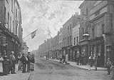
The Highway, formerly known as the Ratcliffe Highway, is a mile-long road in the East End
of London
, with several historic landmarks nearby. The route dates back to Roman
times. In the 19th century it had a very notorious reputation for vice and crime and was the site of the infamous Ratcliff Highway murders
. The name 'Ratcliffe' literally means 'Red Cliff', referring to the red sandstone cliffs which descended from the plateau on which the road was situated down to the Wapping Marshes to the south.
to Limehouse
. It is parallel-to and south of Commercial Road
, the Docklands Light Railway
and Cable Street
. It connects East Smithfield and the Limehouse Link tunnel.
The road forms an unofficial boundary to Wapping
, which lies between the River Thames and The Highway. The road is also close to Shadwell Basin
(to the south east), Tower Hill (to the west), and Whitechapel
and Stepney
(to the north).
The Highway is in the London Borough of Tower Hamlets
, in postal districts E1, E1W and E98.
It lies within the parliamentary constituencies of Bethnal Green and Bow and Poplar and Canning Town.
A Roman bath house was excavated in 2004 by the junction of The Highway and Wapping Lane. The discovery of women’s jewellery along with soldiers' possessions suggests that this location outside of the Roman walls allowed less restricted use of the baths than those in the City itself.
The remains of the baths and under-floor heating system were re-buried (for later archaeologists) under the car park of the new flats.
By 1908, Ratcliffe Highway had different names for each of its sections. From west to east these ran: "St. George's Street East", "High Street (Shadwell) ", "Cock Hill", "Broad Street". The whole of the central area of The Highway was named after St George in the East
church and the parish of St George in the East
.
, and is busy during London rush hours. There are 2 lanes in each direction throughout its length. It lies outside of the London congestion charge
zone.
There are no cycle facilities, and most cyclists use the cycle paths in Cable Street
to the north.
's Zone 2)
London Underground
stations:
Docklands Light Railway
stations:
National Rail
stations:
Politicians
Members of Parliament, Bethnal Green and Bow :
Members of Parliament, Poplar and Canning Town :
Victorian Era
Earlier
People inspiring local street names
North of The Highway starting from the west:
East of The Highway:
South of The Highway starting from the west:
East End of London
The East End of London, also known simply as the East End, is the area of London, England, United Kingdom, east of the medieval walled City of London and north of the River Thames. Although not defined by universally accepted formal boundaries, the River Lea can be considered another boundary...
of London
London
London is the capital city of :England and the :United Kingdom, the largest metropolitan area in the United Kingdom, and the largest urban zone in the European Union by most measures. Located on the River Thames, London has been a major settlement for two millennia, its history going back to its...
, with several historic landmarks nearby. The route dates back to Roman
Ancient Rome
Ancient Rome was a thriving civilization that grew on the Italian Peninsula as early as the 8th century BC. Located along the Mediterranean Sea and centered on the city of Rome, it expanded to one of the largest empires in the ancient world....
times. In the 19th century it had a very notorious reputation for vice and crime and was the site of the infamous Ratcliff Highway murders
Ratcliff Highway murders
The Ratcliff Highway murders were two vicious attacks that resulted in multiple fatalities, and occurred over twelve days in the year 1811, in homes half a mile apart near Wapping in London.-Murders:...
. The name 'Ratcliffe' literally means 'Red Cliff', referring to the red sandstone cliffs which descended from the plateau on which the road was situated down to the Wapping Marshes to the south.
Location
The Highway runs west-east from the eastern edge of The CityCity of London
The City of London is a small area within Greater London, England. It is the historic core of London around which the modern conurbation grew and has held city status since time immemorial. The City’s boundaries have remained almost unchanged since the Middle Ages, and it is now only a tiny part of...
to Limehouse
Limehouse
Limehouse is a place in the London Borough of Tower Hamlets. It is on the northern bank of the River Thames opposite Rotherhithe and between Ratcliff to the west and Millwall to the east....
. It is parallel-to and south of Commercial Road
Commercial Road
Commercial Road , in length, is in the London Borough of Tower Hamlets in the East End of London. It runs from "Gardener's Corner" , through Stepney to the junction with Burdett Road , Limehouse from which point the route becomes the East India Dock Road...
, the Docklands Light Railway
Docklands Light Railway
The Docklands Light Railway is an automated light metro or light rail system opened on 31 August 1987 to serve the redeveloped Docklands area of London...
and Cable Street
Cable Street
Cable Street is a mile-long road in the East End of London, with several historic landmarks nearby, made famous by "the Battle of Cable Street" of 1936.-Location:Cable Street runs between the edge of The City and Limehouse:...
. It connects East Smithfield and the Limehouse Link tunnel.
The road forms an unofficial boundary to Wapping
Wapping
Wapping is a place in the London Borough of Tower Hamlets which forms part of the Docklands to the east of the City of London. It is situated between the north bank of the River Thames and the ancient thoroughfare simply called The Highway...
, which lies between the River Thames and The Highway. The road is also close to Shadwell Basin
Shadwell Basin
Shadwell Basin was part of the London Docks, a group of docks built by the London Dock Company at Wapping, London, and part of the wider docks of the Port of London....
(to the south east), Tower Hill (to the west), and Whitechapel
Whitechapel
Whitechapel is a built-up inner city district in the London Borough of Tower Hamlets, London, England. It is located east of Charing Cross and roughly bounded by the Bishopsgate thoroughfare on the west, Fashion Street on the north, Brady Street and Cavell Street on the east and The Highway on the...
and Stepney
Stepney
Stepney is a district of the London Borough of Tower Hamlets in London's East End that grew out of a medieval village around St Dunstan's church and the 15th century ribbon development of Mile End Road...
(to the north).
The Highway is in the London Borough of Tower Hamlets
London Borough of Tower Hamlets
The London Borough of Tower Hamlets is a London borough to the east of the City of London and north of the River Thames. It is in the eastern part of London and covers much of the traditional East End. It also includes much of the redeveloped Docklands region of London, including West India Docks...
, in postal districts E1, E1W and E98.
It lies within the parliamentary constituencies of Bethnal Green and Bow and Poplar and Canning Town.
History
The Ratcliffe Highway was most probably originally a Roman Road, running east from the City of London along the top of a plateau near the edge of the eponymous 'red cliff' which descended onto the low lying tidal marshes of Wapping to the south.A Roman bath house was excavated in 2004 by the junction of The Highway and Wapping Lane. The discovery of women’s jewellery along with soldiers' possessions suggests that this location outside of the Roman walls allowed less restricted use of the baths than those in the City itself.
The remains of the baths and under-floor heating system were re-buried (for later archaeologists) under the car park of the new flats.
By 1908, Ratcliffe Highway had different names for each of its sections. From west to east these ran: "St. George's Street East", "High Street (Shadwell) ", "Cock Hill", "Broad Street". The whole of the central area of The Highway was named after St George in the East
St George in the East
St George in the East is an Anglican Church and one of six Hawksmoor churches in London, England, built from 1714 to 1729, with funding from the 1711 Act of Parliament...
church and the parish of St George in the East
St George in the East (parish)
St George in the East was a parish in the metropolitan area of London, England.-History:The parish was largely rural at the time of its creation, the main settlement a hamlet known as Wapping Stepney...
.
Landmarks
(West to east)- St Katharine DocksSt Katharine DocksSt Katharine Docks, in the London Borough of Tower Hamlets, were one of the commercial docks serving London, on the north side of the river Thames just east of the Tower of London and Tower Bridge...
- Wellclose SquareWellclose SquareWellclose Square lies in the London Borough of Tower Hamlets, between Cable Street to the north and The Highway to the south.The western edge, now called Ensign Street, was previously called Well Street. The southern edge was called Neptune street. On the north side is Graces Alley, home to...
- St Paul's Primary School
- The Ensign Club — a local youth club
- News InternationalNews InternationalNews International Ltd is the United Kingdom newspaper publishing division of News Corporation. Until June 2002, it was called News International plc....
— head office for the newspaper group, including The TimesThe TimesThe Times is a British daily national newspaper, first published in London in 1785 under the title The Daily Universal Register . The Times and its sister paper The Sunday Times are published by Times Newspapers Limited, a subsidiary since 1981 of News International...
, The Sunday TimesThe Sunday Times (UK)The Sunday Times is a Sunday broadsheet newspaper, distributed in the United Kingdom. The Sunday Times is published by Times Newspapers Ltd, a subsidiary of News International, which is in turn owned by News Corporation. Times Newspapers also owns The Times, but the two papers were founded...
, The SunThe Sun (newspaper)The Sun is a daily national tabloid newspaper published in the United Kingdom and owned by News Corporation. Sister editions are published in Glasgow and Dublin...
, and the News of the WorldNews of the WorldThe News of the World was a national red top newspaper published in the United Kingdom from 1843 to 2011. It was at one time the biggest selling English language newspaper in the world, and at closure still had one of the highest English language circulations... - Telford’s Yard — a converted Victorian wool warehous
- The Caxton (until recently The Artichoke) public house — displays newspaper history on the walls
- Site of the 1st Ratcliff Highway murdersRatcliff Highway murdersThe Ratcliff Highway murders were two vicious attacks that resulted in multiple fatalities, and occurred over twelve days in the year 1811, in homes half a mile apart near Wapping in London.-Murders:...
- Mary Sambrook School
- The Travellers Rest — Evangelical Church
- The Old Rose public house
- Tobacco DockTobacco DockTobacco Dock is a grade I listed warehouse in Wapping, London Docklands. It was constructed in approximately 1811 and served as a store for imported tobacco. It is a brick building with many brick vaults and some fine ironwork...
— the old warehouses for imported tobacco, converted to retail outlets, but closed up by 2000 - St George in the EastSt George in the EastSt George in the East is an Anglican Church and one of six Hawksmoor churches in London, England, built from 1714 to 1729, with funding from the 1711 Act of Parliament...
— the white stone church that has dominated the area since 1729 - Eluna Apartments — new flats replaced Babe Ruth’s Restaurant
- St George's Recreation Ground
- St George’s Swimming Pool
- Green Gables Montessori School
- St. Paul's Church, ShadwellSt. Paul's Church, ShadwellSt Paul's Church, Shadwell, is a historic church, located between The Highway and Shadwell Basin, on the edge of Wapping, in the East End of London, England...
— the Church of Sea Captains - Shadwell BasinShadwell BasinShadwell Basin was part of the London Docks, a group of docks built by the London Dock Company at Wapping, London, and part of the wider docks of the Port of London....
— the old dock now used for watersports and fishing - King Edward VII Memorial Park — giving access to the River ThamesRiver ThamesThe River Thames flows through southern England. It is the longest river entirely in England and the second longest in the United Kingdom. While it is best known because its lower reaches flow through central London, the river flows alongside several other towns and cities, including Oxford,...
- Express by Holiday InnHoliday InnHoliday Inn is a brand of hotels, formally a economy motel chain, forming part of the British InterContinental Hotels Group . It is one of the world's largest hotel chains with 238,440 bedrooms and 1,301 hotels globally. There are currently 5 hotels in the pipeline...
Limehouse — 3 star hotel with 150 rooms, built in 2004 - Limehouse Link tunnelLimehouse Link tunnelThe Limehouse Link tunnel is a 1.1 mile long tunnel in the Limehouse area of east London on the A1203 road which runs from the northern approach to Tower Bridge eastwards to a point just north of Canary Wharf in London Docklands...
Road
The Highway is a major arterial route into and out of The CityCity of London
The City of London is a small area within Greater London, England. It is the historic core of London around which the modern conurbation grew and has held city status since time immemorial. The City’s boundaries have remained almost unchanged since the Middle Ages, and it is now only a tiny part of...
, and is busy during London rush hours. There are 2 lanes in each direction throughout its length. It lies outside of the London congestion charge
London congestion charge
The London congestion charge is a fee charged for some categories of motor vehicle to travel at certain times within the Congestion Charge Zone , a traffic area in London. The charge aims to reduce congestion, and raise investment funds for London's transport system...
zone.
There are no cycle facilities, and most cyclists use the cycle paths in Cable Street
Cable Street
Cable Street is a mile-long road in the East End of London, with several historic landmarks nearby, made famous by "the Battle of Cable Street" of 1936.-Location:Cable Street runs between the edge of The City and Limehouse:...
to the north.
Bus
There are few bus stops on The Highway, but buses 100 and D3 pass along short lengths of it to get to Wapping and Shadwell.- 100 connects to ShadwellShadwellShadwell is an inner-city district situated within the London Borough of Tower Hamlets located on the north bank of the Thames between Wapping to the south and Ratcliff to the east...
, Liverpool StreetLiverpool StreetLiverpool Street can refer to:*Liverpool Street station, a major mainline railway station in Central London, England*Liverpool Street, Hobart, a major street in the Hobart city centre....
, St PaulsSt Paul's CathedralSt Paul's Cathedral, London, is a Church of England cathedral and seat of the Bishop of London. Its dedication to Paul the Apostle dates back to the original church on this site, founded in AD 604. St Paul's sits at the top of Ludgate Hill, the highest point in the City of London, and is the mother...
and Elephant and CastleElephant and CastleThe Elephant and Castle is a major road intersection in south London, England, located in the London Borough of Southwark. It is also used as a name for the surrounding area....
. - D3 connects to Isle of DogsIsle of DogsThe Isle of Dogs is a former island in the East End of London that is bounded on three sides by one of the largest meanders in the River Thames.-Etymology:...
, LimehouseLimehouseLimehouse is a place in the London Borough of Tower Hamlets. It is on the northern bank of the River Thames opposite Rotherhithe and between Ratcliff to the west and Millwall to the east....
, ShadwellShadwellShadwell is an inner-city district situated within the London Borough of Tower Hamlets located on the north bank of the Thames between Wapping to the south and Ratcliff to the east...
and Bethnal GreenBethnal GreenBethnal Green is a district of the East End of London, England and part of the London Borough of Tower Hamlets, with the far northern parts falling within the London Borough of Hackney. Located northeast of Charing Cross, it was historically an agrarian hamlet in the ancient parish of Stepney,...
.
Rail
(All in Transport for LondonTransport for London
Transport for London is the local government body responsible for most aspects of the transport system in Greater London in England. Its role is to implement the transport strategy and to manage transport services across London...
's Zone 2)
London Underground
London Underground
The London Underground is a rapid transit system serving a large part of Greater London and some parts of Buckinghamshire, Hertfordshire and Essex in England...
stations:
- Shadwell tube stationShadwell DLR stationShadwell DLR station on the Docklands Light Railway is between the terminals of Bank and Tower Gateway to the west and Limehouse to the east. The 1991 Bank extension joins the main DLR line just to the west of Shadwell.-History:...
: on the East London LineEast London LineThe East London Line is a London Overground line which runs north to south through the East End, Docklands and South areas of London.Built in 1869 by the East London Railway Company, which reused the Thames Tunnel, originally intended for horse-drawn carriages, the line became part of the London... - Wapping tube stationWapping tube stationWapping railway station is on the northern bank of the river Thames in Wapping, East London, England. It is in Zone 2, and on the East London Line of London Overground between and ....
: on the East London LineEast London LineThe East London Line is a London Overground line which runs north to south through the East End, Docklands and South areas of London.Built in 1869 by the East London Railway Company, which reused the Thames Tunnel, originally intended for horse-drawn carriages, the line became part of the London... - Tower Hill tube stationTower Hill tube stationTower Hill is a London Underground station at Tower Hill in the London Borough of Tower Hamlets.The station is in Travelcard Zone 1 and near the Tower of London...
: on the Circle Line and District LineDistrict LineThe District line is a line of the London Underground, coloured green on the Tube map. It is a "sub-surface" line, running through the central area in shallow cut-and-cover tunnels. It is the busiest of the sub-surface lines. Out of the 60 stations served, 25 are underground...
Docklands Light Railway
Docklands Light Railway
The Docklands Light Railway is an automated light metro or light rail system opened on 31 August 1987 to serve the redeveloped Docklands area of London...
stations:
- Shadwell DLR stationShadwell DLR stationShadwell DLR station on the Docklands Light Railway is between the terminals of Bank and Tower Gateway to the west and Limehouse to the east. The 1991 Bank extension joins the main DLR line just to the west of Shadwell.-History:...
- Limehouse DLR stationLimehouse stationLimehouse station is a railway station located in the Limehouse district of east London. The station is in Travelcard Zone 2 and is served by Docklands Light Railway services and by National Rail services operated by c2c out of Fenchurch Street station...
National Rail
National Rail
National Rail is a title used by the Association of Train Operating Companies as a generic term to define the passenger rail services operated in Great Britain...
stations:
- Limehouse railway stationLimehouse stationLimehouse station is a railway station located in the Limehouse district of east London. The station is in Travelcard Zone 2 and is served by Docklands Light Railway services and by National Rail services operated by c2c out of Fenchurch Street station...
People
Some names associated with the area:Politicians
Members of Parliament, Bethnal Green and Bow :
- George GallowayGeorge GallowayGeorge Galloway is a British politician, author, journalist and broadcaster who was a Member of Parliament from 1987 to 2010. He was formerly an MP for the Labour Party, first for Glasgow Hillhead and later for Glasgow Kelvin, before his expulsion from the party in October 2003, the same year...
, RespectRESPECT The Unity CoalitionRespect is a socialist political party in England and Wales founded in 2004. Its name is a contrived acronym standing for Respect, Equality, Socialism, Peace, Environmentalism, Community and Trade Unionism.-Policies:...
(MP 2005- ) - Oona KingOona KingOona Tamsyn King, Baroness King of Bow is a Baroness and Member of the House of Lords, and former Chief Diversity Officer of Channel 4. She previously had served as a Labour Party Member of Parliament for Bethnal Green and Bow from 1997 until 2005, when she was defeated by Respect candidate George...
, LabourLabour Party (UK)The Labour Party is a centre-left democratic socialist party in the United Kingdom. It surpassed the Liberal Party in general elections during the early 1920s, forming minority governments under Ramsay MacDonald in 1924 and 1929-1931. The party was in a wartime coalition from 1940 to 1945, after...
(MP 1997-2005)
Members of Parliament, Poplar and Canning Town :
- Jim FitzpatrickJim Fitzpatrick (politician)James Fitzpatrick is a British Labour Party politician, who has been the Member of Parliament for Poplar and Limehouse since the 2010 General Election. From 1997 to the 2010 election he was the member for Poplar and Canning Town...
, LabourLabour Party (UK)The Labour Party is a centre-left democratic socialist party in the United Kingdom. It surpassed the Liberal Party in general elections during the early 1920s, forming minority governments under Ramsay MacDonald in 1924 and 1929-1931. The party was in a wartime coalition from 1940 to 1945, after...
(MP 1997- )
Victorian Era
- Sir William Henry Perkin (1838–1907) chemist who discovered anilineAnilineAniline, phenylamine or aminobenzene is an organic compound with the formula C6H5NH2. Consisting of a phenyl group attached to an amino group, aniline is the prototypical aromatic amine. Being a precursor to many industrial chemicals, its main use is in the manufacture of precursors to polyurethane...
purple dye was baptised at St. Paul's Church, ShadwellSt. Paul's Church, ShadwellSt Paul's Church, Shadwell, is a historic church, located between The Highway and Shadwell Basin, on the edge of Wapping, in the East End of London, England... - Oscar WildeOscar WildeOscar Fingal O'Flahertie Wills Wilde was an Irish writer and poet. After writing in different forms throughout the 1880s, he became one of London's most popular playwrights in the early 1890s...
(1854–1900) visited the opium dens near Dellow Street - Arthur Conan DoyleArthur Conan DoyleSir Arthur Ignatius Conan Doyle DL was a Scottish physician and writer, most noted for his stories about the detective Sherlock Holmes, generally considered a milestone in the field of crime fiction, and for the adventures of Professor Challenger...
(1859–1930) visited the opium dens as research for his detective character Sherlock HolmesSherlock HolmesSherlock Holmes is a fictional detective created by Scottish author and physician Sir Arthur Conan Doyle. The fantastic London-based "consulting detective", Holmes is famous for his astute logical reasoning, his ability to take almost any disguise, and his use of forensic science skills to solve...
. - Charles JamrachCharles JamrachCharles Jamrach was a leading dealer in wild animals, birds and shells in 19th century London. His nearest rival was Edward Cross, who ran the menagerie at Exeter Exchange in the Strand....
was the most extensive dealer in wild animals in the world, and had his shop on The Highway.
Earlier
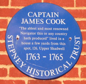
- Captain James CookJames CookCaptain James Cook, FRS, RN was a British explorer, navigator and cartographer who ultimately rose to the rank of captain in the Royal Navy...
(1728–1779) lived in the area, and baptised some of his children at St. Paul's Church, ShadwellSt. Paul's Church, ShadwellSt Paul's Church, Shadwell, is a historic church, located between The Highway and Shadwell Basin, on the edge of Wapping, in the East End of London, England...
, on Ratcliffe Highway. A blue plaqueBlue plaqueA blue plaque is a permanent sign installed in a public place to commemorate a link between that location and a famous person or event, serving as a historical marker....
commemorates him at 326 The Highway.
- (A slate plaque also marks his home at 88 Mile End Road).
- Jane Randolph (1720–1776), mother of Thomas JeffersonThomas JeffersonThomas Jefferson was the principal author of the United States Declaration of Independence and the Statute of Virginia for Religious Freedom , the third President of the United States and founder of the University of Virginia...
, was baptised at St. Paul's Church, ShadwellSt. Paul's Church, ShadwellSt Paul's Church, Shadwell, is a historic church, located between The Highway and Shadwell Basin, on the edge of Wapping, in the East End of London, England... - John WesleyJohn WesleyJohn Wesley was a Church of England cleric and Christian theologian. Wesley is largely credited, along with his brother Charles Wesley, as founding the Methodist movement which began when he took to open-air preaching in a similar manner to George Whitefield...
(1703–1791) preached at St. Paul's Church, Shadwell. - Nicholas HawksmoorNicholas HawksmoorNicholas Hawksmoor was a British architect born in Nottinghamshire, probably in East Drayton.-Life:Hawksmoor was born in Nottinghamshire in 1661, into a yeoman farming family, almost certainly in East Drayton, Nottinghamshire. On his death he was to leave property at nearby Ragnall, Dunham and a...
(1661–1736) architect who designed the church of St. George in the East, a prominent landmark halfway along The Highway.
- Jane Randolph (1720–1776), mother of Thomas Jefferson
People inspiring local street names
- Nathaniel HeckfordNathaniel HeckfordDr. Nathaniel Heckford was a paediatrician in Victorian London, who founded the East London Hospital for Children. He met his future wife, Sarah Goff, during the 1866 cholera epidemic in Wapping, where he first determined a need for a children's hospital in East London...
— a young doctor who founded a local children's hospital - Daniel SolanderDaniel SolanderDaniel Carlsson Solander or Daniel Charles Solander was a Swedish naturalist and an apostle of Carl Linnaeus. Solander was the first university educated scientist to set foot on Australian soil.-Biography:...
— Swedish botanist who travelled with James CookJames CookCaptain James Cook, FRS, RN was a British explorer, navigator and cartographer who ultimately rose to the rank of captain in the Royal Navy...
exploring the Pacific islands - Emanuel SwedenborgEmanuel Swedenborgwas a Swedish scientist, philosopher, and theologian. He has been termed a Christian mystic by some sources, including the Encyclopædia Britannica online version, and the Encyclopedia of Religion , which starts its article with the description that he was a "Swedish scientist and mystic." Others...
— Swedish scientist, philosopher and mystic, in the Georgian era
Neighbouring streets
West of The Highway:- East SmithfieldEast SmithfieldEast Smithfield is the name of a road in the London Borough of Tower Hamlets in east London, part of the A1203 road. It was historically an alternative name for the liberty and parish of St Botolph without Aldgate....
North of The Highway starting from the west:
- Cable StreetCable StreetCable Street is a mile-long road in the East End of London, with several historic landmarks nearby, made famous by "the Battle of Cable Street" of 1936.-Location:Cable Street runs between the edge of The City and Limehouse:...
— runs parallel to The Highway - Dock Street — already existed as Dock Street in 1830
- Ensign Street — formerly Wells Street (in 1862)
- Hard's Place — a path between Wellclose Square and the south end of Ensign Street
- Graces Alley — formerly Gracies Alley — a path between Wellclose Square and the north end of Ensign Street — home to Wilton's Music HallWilton's Music HallWilton's Music Hall is a grade II* listed building, built as a music hall and now a more general-purpose performance space in Grace's Alley, off Cable Street in the London Borough of Tower Hamlets...
- Wellclose SquareWellclose SquareWellclose Square lies in the London Borough of Tower Hamlets, between Cable Street to the north and The Highway to the south.The western edge, now called Ensign Street, was previously called Well Street. The southern edge was called Neptune street. On the north side is Graces Alley, home to...
— already existed as Wellclose Square in 1830 & 1862 - SwedenbourgEmanuel Swedenborgwas a Swedish scientist, philosopher, and theologian. He has been termed a Christian mystic by some sources, including the Encyclopædia Britannica online version, and the Encyclopedia of Religion , which starts its article with the description that he was a "Swedish scientist and mystic." Others...
Gardens - Princes Square — no longer exists: replaced by a small park
- Betts Street — formerly connected Cable Street to The Highway (in 1862)
- Crowder Street — formerly Denmark Street (in 1862)
- Cannon Street Road
- Dellow Street
- SolanderDaniel SolanderDaniel Carlsson Solander or Daniel Charles Solander was a Swedish naturalist and an apostle of Carl Linnaeus. Solander was the first university educated scientist to set foot on Australian soil.-Biography:...
Gardens - King David Lane
- Juniper Street — formerly Juniper Row (in 1862)
- Tarbert Walk
- Redcastle Close — formerly Carriage Way (in 1862)
- Glamis Road
- Glamis Place
- Brodlove Lane — formerly Love Lane (in 1862)
- Elf Row — formerly Elm Row (in 1862)
- Glasshouse Fields — formerly Glasshouse Street (in 1862)
- Schoolhouse Lane
- HeckfordNathaniel HeckfordDr. Nathaniel Heckford was a paediatrician in Victorian London, who founded the East London Hospital for Children. He met his future wife, Sarah Goff, during the 1866 cholera epidemic in Wapping, where he first determined a need for a children's hospital in East London...
Street — formerly Burlington Place (in 1862) — a trades wholesaler park - Ratcliffe Orchard — formerly The Orchard (in 1862)
East of The Highway:
- Butcher Row — formerly Butcher Row and White Horse Street (in 1862)
- Narrow StreetNarrow StreetNarrow Street is a narrow street running parallel to the River Thames through the Limehouse area of east London.- History :A combination of tides and currents made this point on the Thames a natural landfall for ships, the first wharf being completed in 1348...
- Limehouse Link tunnelLimehouse Link tunnelThe Limehouse Link tunnel is a 1.1 mile long tunnel in the Limehouse area of east London on the A1203 road which runs from the northern approach to Tower Bridge eastwards to a point just north of Canary Wharf in London Docklands...
— a road tunnel to:- West India Dock Road &
- Aspen Way (north of Canary WharfCanary WharfCanary Wharf is a major business district located in London, United Kingdom. It is one of London's two main financial centres, alongside the traditional City of London, and contains many of the UK's tallest buildings, including the second-tallest , One Canada Square...
)
South of The Highway starting from the west:
- Vaughan Way
- Virginia Street — existed by 1862
- Telford's Yard
- Breezers Hill — existed by 1862
- Artichoke Hill — existed by 1862 (the escape route for the Ratcliff Highway murderers)
- Chigwell Hill — existed by 1862
- Pennington Street — existed by 1862
- Wapping Lane — formerly Old Gravel Lane (in 1862)
- Sovereign Close
- Princes Court
- West Gardens — existed by 1862
- Rum Close
- Garnet Street — formerly New Gravel Lane (in 1862)
- Newlands Quay — formerly Elbow Lane (in 1862)
- Maynards Quay
- Glamis Road
- Pear Tree Lane — formerly Fox's Lane (in 1862). Named after The Pear Tree, the inn where the second group of Ratcliff Highway murdersRatcliff Highway murdersThe Ratcliff Highway murders were two vicious attacks that resulted in multiple fatalities, and occurred over twelve days in the year 1811, in homes half a mile apart near Wapping in London.-Murders:...
took place. - Shadwell Basin — leading to the water sports activity centre in the former dock
- Jardine Road
- Rialto Avenue
See also
- Ratcliff Highway murdersRatcliff Highway murdersThe Ratcliff Highway murders were two vicious attacks that resulted in multiple fatalities, and occurred over twelve days in the year 1811, in homes half a mile apart near Wapping in London.-Murders:...
- Cable StreetCable StreetCable Street is a mile-long road in the East End of London, with several historic landmarks nearby, made famous by "the Battle of Cable Street" of 1936.-Location:Cable Street runs between the edge of The City and Limehouse:...
- Fairport ConventionFairport ConventionFairport Convention are an English folk rock and later electric folk band, formed in 1967 who are still recording and touring today. They are widely regarded as the most important single group in the English folk rock movement...
. Ratcliffe Highway is referred to in a song entitled "The Deserter" on their 1969 Liege and Lief LP.