
Indigirka River
Encyclopedia
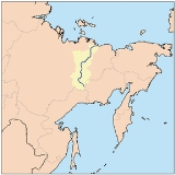
The Indigirka River is a river in the Sakha Republic in Russia
between the Yana River
and the Kolyma River
. It is 1726 kilometres (1,072.5 mi) in length. The area of its basin
is 360,000 km². The river flows into the Kolyma Bay
, East Siberian Sea
.
It freezes up in October and stays under the ice until May–June.
are the:
There is a gold prospecting
industry in the Indigirka basin. Ust-Nera
, a gold-mining center, is the largest settlement on the river.
The Indigirka River teems with a variety of fishes. Among the most valuable are several whitefish
species, such as vendace
, chir
, muksun
, inconnu
(nelma), omul
, etc.
to the Indigirka. In 1642 Mikhail Stadukhin
reached the Indigirka overland from the Lena.
Zashiversk
on the Indigirka was an important colonial outpost during the early days of Russian colonization. It was subsequently abandoned in the 19th century. Other historical settlements, now long abandoned, were Podshiversk and Uyandinskoye Zimov'ye.
In 1892-1894 Baron Eduard Von Toll carried out geological surveys in the basin of the Indigirka (among other Far-eastern Siberian rivers) on behalf of the Russian Academy of Sciences. During one year and two days the expedition covered 25,000 km, of which 4,200 km were up rivers, carrying out geodesic surveys en route.
The isolated village of Russkoye Ustye
, near the mouths of the Indigirka, is known for the unique traditional culture of the Russian settlers whose ancestors came there several centuries ago.
, consisting of a number of streams (each one being labeled on Russian maps as a protoka (river arm
)) and islands. About 100 km before reaching the East Siberian Sea (70.8126°N 148.9162°E), the river splits into two major northeast-flowing streams
. The left (westernmost) arm is known as the Russko-Ustyinskaya Protoka; the right arm, the Srednyaya Protoka (Russian for the "Middle Arm"). Further downstream, the third major arm, the Kolymskaya Protoka splits off the Srednyaya Protoka as its right (eastern) distributary, thus justifying the "middle" moniker for the Srednyaya Protoka.
While Srednyaya Protoka means the "Middle Arm", the names of the main western and eastern arms indicate their relative location as well. The Kolymskaya Protoka, or Kolymskoye Ustye is the arm one located on the eastern side, i.e. the "Kolyma side" of the delta (the arm closest to the Kolyma
, the eastern neighbor of the Indigirka). The Russko-Ustyinskaya Protoka, apparently known earlier as simply Russkoye Ustye is the arm one located on the western side, i.e. the "Russian side" of the delta (meaning, the side closest to the (European) Russia). These days the name of the Russko-Ustyinskaya Protoka appears as if it were formed from the name of the old Russian village Russkoye Ustye
situated there, but originally the opposite is likely to have been the case, the village being named after the river arm (the Russkoye Ustye) on which it was located.
Several flat islands are formed by the channels of the delta. Listed from the east to the west, the major ones are:
Russia
Russia or , officially known as both Russia and the Russian Federation , is a country in northern Eurasia. It is a federal semi-presidential republic, comprising 83 federal subjects...
between the Yana River
Yana River
The Yana River , is a river in Sakha in Russia, located between the Lena to the west and the Indigirka to the east.It is 872 km in length. The area of its basin is 238,000 km², whilst its annual discharge totals approximately . Most of this discharge occurs in May and June as the ice on the...
and the Kolyma River
Kolyma River
The Kolyma River is a river in northeastern Siberia, whose basin covers parts of the Sakha Republic, Chukotka Autonomous Okrug, and Magadan Oblast of Russia. Itrises in the mountains north of Okhotsk and Magadan, in the area of and...
. It is 1726 kilometres (1,072.5 mi) in length. The area of its basin
Drainage basin
A drainage basin is an extent or an area of land where surface water from rain and melting snow or ice converges to a single point, usually the exit of the basin, where the waters join another waterbody, such as a river, lake, reservoir, estuary, wetland, sea, or ocean...
is 360,000 km². The river flows into the Kolyma Bay
Kolyma Bay
The Kolyma Bay is one of the main gulfs of the East Siberian Sea.The bay gets its name from the Kolyma Lowlands, whose coastline forms the whole eastern half of this bay. The Kolyma Lowlands are dotted with numerous lakes and swamps...
, East Siberian Sea
East Siberian Sea
The East Siberian Sea is a marginal sea in the Arctic Ocean. It is located between the Arctic Cape to the north, the coast of Siberia to the south, the New Siberian Islands to the west and Cape Billings, close to Chukotka, and Wrangel Island to the east...
.
It freezes up in October and stays under the ice until May–June.
Tributaries
The main tributariesTributary
A tributary or affluent is a stream or river that flows into a main stem river or a lake. A tributary does not flow directly into a sea or ocean...
are the:
- Kuydusun River
- Kyuente River
- Elgi RiverElgi RiverElgi River is a river in Yakutia in Russia, a left tributary of the Indigirka River. It is formed by the confluence of the Degdega and Kao Rivers. The length of the Elgi is . The area of its drainage basin is 68,200 km². The Elgi freezes up in October and remains icebound until late May - early...
- Nera RiverNera River (Russia)Nera River is a river in Sakha Republic, Russia, and is a right tributary of the Indigirka River. The river is long and has a drainage basin of . The Nera freezes up in October and remains icebound until May - early June...
, - Moma RiverMoma RiverMoma River is a river in Yakutia in Russia, a right tributary of the Indigirka River. The length of the Moma is 406 km. The area of its drainage basin is 30,200 km²....
- Badyarikha RiverBadyarikha RiverBadyarikha River is a river in Yakutia in Russia, a right tributary of the Indigirka River. The length of the Badyarikha is . The area of its drainage basin is 12,200 km². Its main tributaries are the Ogorokha, Orto-Tirekhtyakh, and Anty Rivers....
- Seleniyakh River
- UyandinaUyandina RiverUyandina River is a river in Yakutia in Russia, a left tributary of the Indigirka River. It is formed by the confluence of the Irgichyan and Baky Rivers. The length of the Uyandina is 586 km. The area of its drainage basin is 177,000 km². The Uyandina freezes up in October and remains icebound...
Ports, Settlements & Economy
Main ports on the river are:- KhonuuKhonuuKhonuu is a village in the Sakha Republic, Russia, and is the administrative center of the Momsky District. It is located on the east side of the Indigirka River. The local population are primarily Yakuts who are hunters or reindeer herders....
- DruzhinaDruzhina, Sakha RepublicDruzhina is a village in Abyysky Ulus of the Sakha Republic, Russia, a port by the left bank of the Indigirka River. It is located about 2,800 km northeast of Yakutsk and 120 km southwest from the Belaya Gora, ulus' administrative center...
- ChokurdakhChokurdakhChokurdakh is an urban locality and the administrative center of Allaikhovsky District of the Sakha Republic, Russia. Population: The Indigirka River flows through the settlement. It is served by Chokurdakh Airport....
- Tabor.
There is a gold prospecting
Gold prospecting
Gold prospecting is the act of searching for new gold deposits. Methods used vary with the type of deposit sought and the resources of the prospector...
industry in the Indigirka basin. Ust-Nera
Ust-Nera
Ust-Nera is an urban locality and the administrative center of Oymyakonsky District of the Sakha Republic, Russia, located at the confluence of the Nera and the Indigirka Rivers. Population:...
, a gold-mining center, is the largest settlement on the river.
The Indigirka River teems with a variety of fishes. Among the most valuable are several whitefish
Freshwater whitefish
The freshwater whitefish are fish of the subfamily Coregoninae in the salmon family Salmonidae. Along with the freshwater whitefish, the Salmonidae includes the freshwater and anadromous trout and salmon species as well as graylings...
species, such as vendace
Coregonus albula
The vendace, Coregonus albula, is a species of freshwater whitefish in the family Salmonidae. It is also known as the European cisco. It is found in lakes in northern Europe, especially Finland, Sweden, Russia and Estonia, and in some lakes of the United Kingdom, northern Germany and Poland...
, chir
Broad Whitefish
The broad whitefish is a freshwater whitefish species. Dark silvery in colour, and like a herring in its shape, its distinctive features include a convex head, short gill rakers, and a mild overbite. It is found in the Arctic-draining streams, lakes, and rivers of far eastern Russia and North...
, muksun
Muksun
The Muksun is a type of whitefish. Its name is derived from its Russian name Муксун.The muksun is a widespread fish in the Siberian Arctic waters. It is mostly found in the freshened areas of the Kara and Laptev Seas and up the major rivers, as well as in Lake Taymyr.Like all whitefishes, it is a...
, inconnu
Inconnu
Stenodus leucichthys is a species of freshwater whitefish in the family Salmonidae. It is also known variously by the common names sheefish, inconnu, connie, nelma and beloribitsa...
(nelma), omul
Omul
The omul, Coregonus migratorius, also known as Baikal omul , is a whitefish species of the salmon family endemic to Lake Baikal in Siberia, Russia. It is considered a delicacy and is the object of one of the largest commercial fisheries on Lake Baikal...
, etc.
History
In 1638 Ivan Rebrov reached the Indigirka. In 1636-42 Elisei Buza pioneered the overland route to the Indigirka river system. At about the same time, Poznik Ivanov ascended a tributary of the lower Lena, crossed the Verkhoyansk Range to the upper Yana and then crossed the Chersky RangeChersky Range
The Chersky Range is a chain of mountains in northeastern Siberia between the Yana River and the Indigirka River. It generally runs from northwest to southeast through the Sakha Republic and Magadan Oblast. The tallest mountain in the range is Peak Pobeda, which is 3,003 meters tall. The range...
to the Indigirka. In 1642 Mikhail Stadukhin
Mikhail Stadukhin
Mikhail Vasilyevich Stadukhin was a Russian explorer of far northeast Siberia, one of the first to reach the Kolyma, Anadyr, Penzhina and Gizhiga Rivers and the northern Sea of Okhotsk. He was a Pomor, probably born in the village of Pinega, and the nephew of a Moscow merchant...
reached the Indigirka overland from the Lena.
Zashiversk
Zashiversk
Zashiversk was a town north of the arctic circle in what is now the Sakha Republic , Russia. It was located on the right bank of the Indigirka River where the river makes a sharp bend around the town-site. It was founded in 1639. It served as a fortress town and then as an administrative center....
on the Indigirka was an important colonial outpost during the early days of Russian colonization. It was subsequently abandoned in the 19th century. Other historical settlements, now long abandoned, were Podshiversk and Uyandinskoye Zimov'ye.
In 1892-1894 Baron Eduard Von Toll carried out geological surveys in the basin of the Indigirka (among other Far-eastern Siberian rivers) on behalf of the Russian Academy of Sciences. During one year and two days the expedition covered 25,000 km, of which 4,200 km were up rivers, carrying out geodesic surveys en route.
The isolated village of Russkoye Ustye
Russkoye Ustye
Russkoye Ustye is a village in Allaikhovsky Ulus of the Sakha Republic, Russia. For several decades during the Soviet era, the village was officially called Polyarny ....
, near the mouths of the Indigirka, is known for the unique traditional culture of the Russian settlers whose ancestors came there several centuries ago.
Shipping of the Indigirka
Mouths of the Indigirka
The Indigirka forms a large deltaRiver delta
A delta is a landform that is formed at the mouth of a river where that river flows into an ocean, sea, estuary, lake, reservoir, flat arid area, or another river. Deltas are formed from the deposition of the sediment carried by the river as the flow leaves the mouth of the river...
, consisting of a number of streams (each one being labeled on Russian maps as a protoka (river arm
Distributary
A distributary, or a distributary channel, is a stream that branches off and flows away from a main stream channel. They are a common feature of river deltas. The phenomenon is known as river bifurcation. The opposite of a distributary is a tributary...
)) and islands. About 100 km before reaching the East Siberian Sea (70.8126°N 148.9162°E), the river splits into two major northeast-flowing streams
Distributary
A distributary, or a distributary channel, is a stream that branches off and flows away from a main stream channel. They are a common feature of river deltas. The phenomenon is known as river bifurcation. The opposite of a distributary is a tributary...
. The left (westernmost) arm is known as the Russko-Ustyinskaya Protoka; the right arm, the Srednyaya Protoka (Russian for the "Middle Arm"). Further downstream, the third major arm, the Kolymskaya Protoka splits off the Srednyaya Protoka as its right (eastern) distributary, thus justifying the "middle" moniker for the Srednyaya Protoka.
While Srednyaya Protoka means the "Middle Arm", the names of the main western and eastern arms indicate their relative location as well. The Kolymskaya Protoka, or Kolymskoye Ustye is the arm one located on the eastern side, i.e. the "Kolyma side" of the delta (the arm closest to the Kolyma
Kolyma
The Kolyma region is located in the far north-eastern area of Russia in what is commonly known as Siberia but is actually part of the Russian Far East. It is bounded by the East Siberian Sea and the Arctic Ocean in the north and the Sea of Okhotsk to the south...
, the eastern neighbor of the Indigirka). The Russko-Ustyinskaya Protoka, apparently known earlier as simply Russkoye Ustye is the arm one located on the western side, i.e. the "Russian side" of the delta (meaning, the side closest to the (European) Russia). These days the name of the Russko-Ustyinskaya Protoka appears as if it were formed from the name of the old Russian village Russkoye Ustye
Russkoye Ustye
Russkoye Ustye is a village in Allaikhovsky Ulus of the Sakha Republic, Russia. For several decades during the Soviet era, the village was officially called Polyarny ....
situated there, but originally the opposite is likely to have been the case, the village being named after the river arm (the Russkoye Ustye) on which it was located.
Several flat islands are formed by the channels of the delta. Listed from the east to the west, the major ones are:
- Usun-Ary 71.387°N 151.255°E lies longitudinally along the coast east of the Srednyaya mouth. It is 12 km long and 2.7 km wide.
- Uparovskiy Island 71.582°N 151.196°E lies completely detached 11 km offshore from the Srednyaya mouth. It is about 2 km long and 1 km wide.
- Ploskiy Island 71.480°N 150.890°E is the farthest offshore of a cluster of islands at the Srednyaya mouth. It is C-shaped and about 3 km long.
- Bolshoy Fedorovskiy 71.533°N 150.510°E lies between the two mouths of the Indigirka. It is 6 km long and has a maximum width of 4 km.
- Vkodnoy and Oleniy islands lie right at the Prot. Russko Ust'inskaya mouth 71.546°N 150.266°E. Both are of similar size, about 4 km in length.
- Krestovyy Island 71.447°N 149.766°E lies quiet isolated directly to the south of the Lopatka Peninsula, 10 km offshore to the NW of the main Indigirka mouths. It is 6 km long and 1.6 km wide.