

The Needles
Encyclopedia
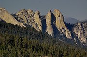
The Needles is a row of three distinctive stacks
of chalk
that rise out of the sea
off the western extremity of the Isle of Wight
, England, close to Alum Bay
. The Needles lighthouse
stands at the end of the formation. Built in 1859, it has been automated since 1994.
The formation takes its name from the former fourth needle-shaped pillar called Lot's Wife that used to stand in its midst until it collapsed in a storm in 1764. The remaining rocks are all short and squat and not at all needle-like, but the name has stuck.
The Needles were featured on the 2005 TV programme Seven Natural Wonders
as one of the wonders of Southern England
.
, and a major tourist draw. Scenic boat trips operating from Alum Bay offering close-up views of the Needles are very popular. The rocks and lighthouse have become icons of the Isle of Wight
, and are featured on many of the souvenirs sold throughout the island.
However, the main tourist attractions of the headland itself are the two gun batteries, the experimental rocket testing station, and the four Coastguard
cottages owned by the National Trust
and let as holiday homes.
The site is on tour bus routes and hiking trails.
, from the 1860s to 1954, when they were eventually decommissioned.
A nearby site on High Down was employed in the testing of rockets for the British ICBM program. The headland at High Down was used for Black Knight
and Black Arrow
rocket engine
tests from 1956–71. During the peak of activity in the early 1960s some 240 people worked at the complex, while the rockets were built in nearby East Cowes
. These rockets were later used to launch the Prospero X-3
satellite. The site is now owned by the National Trust
, and is open to the public. Concrete installations remain, but the buildings that were less durable have either been demolished or were torn down by the elements.
In 1982, HRH Prince Charles officially opened the restored Needles Old Battery facility. Underground rocket testing rooms are currently being restored for exhibition. The first phase of restoration was completed in 2004.
.
In the Spring and Summer, the Southern Vectis
bus company sends open-top buses along a route called "The Needles Tour". This route approaches the Battery along the cliff edge, using a road reserved for bus traffic. The Needles Tour also has stops in Alum Bay
, Totland
, Colwell Bay
, Fort Victoria
, Yarmouth
, and Freshwater Bay
. The Needles Tour buses are the only vehicles allowed on the road from Alum Bay, apart from those owned by National Trust staff or, by prior appointment, vehicles transporting disabled visitors. This is because the single track road's position close to the cliff edge is considered dangerous for multiple car use.
The Isle of Wight Coast Path has its westernmost point at the Coastguard Cottages.
 The Needles pointed shape is a result of their unusual geology. The strata
have been so heavily folded during the Alpine Orogeny
that the chalk
is near vertical. This chalk outcrop runs through the centre of the Island from Culver Cliff
in the east to the Needles in the west, and then continues under the sea to the Isle of Purbeck
, forming Ballard Cliff
(near Swanage
), Lulworth Cove
and Durdle Door
. It is also believed that The Needles were once connected to Old Harry Rocks
(east of Studland
and north of Swanage
) where these strata lines moving from horizontal to near vertical can be seen from the sea.
Just off the end of the Needles formation is the Shingles, a shifting shoal
of pebbles just beneath the waves. The Shingles is approximately three miles in length. Many ships have been wrecked on the Shingles.
landscape artist Lambert Doomer
(1624–1700) made in 1646 depicts a rock formation with much stouter shape than that shown in Isaac Taylor's 1759 "one inch" map of Hampshire. The Doomer etching is contained in Atlas Blaeu-Van der Hem (published ca. 1662), which is in the Austrian National Library
in Vienna. It is not clear from these drawings what transpired.
in 1859 on the outermost of the chalk rocks near sea level. Designed by James Walker
, it cost £20,000. Constructed from granite, it stands 33.25 metres (109.1 ft) high and is a circular tower with straight sides. It replaced a 1786 light tower built on top of a cliff overhanging Scratchell's Bay
, whose height of 144m above sea level meant it was often obscured by fog and sea mists.
In 1987 a helipad was added to the top of the lighthouse, and it became fully automated when the last keepers left on 8 December 1994. One of the last three remaining manned rock lighthouses in England and Wales, before automation it was staffed by a three man crew operating a 24 hour watch, serving one month on / one month off, living in rudimentary conditions in three levels below the light.
Due to the condition of the chalk strata on which the lighthouse was built, in April 2010 a £500,000 underpinning project was announced, designed to stop the lighthouse falling into the sea. Over a 12 week period from early June, civil marine contractors Nuttall John Martin were due to dig a trench around the base of the lighthouse, install a ring of stabilising posts, and infill it with concrete.
Stack (geology)
A stack is a geological landform consisting of a steep and often vertical column or columns of rock in the sea near a coast, isolated by erosion. Stacks are formed through processes of coastal geomorphology, which are entirely natural. Time, wind and water are the only factors involved in the...
of chalk
Chalk
Chalk is a soft, white, porous sedimentary rock, a form of limestone composed of the mineral calcite. Calcite is calcium carbonate or CaCO3. It forms under reasonably deep marine conditions from the gradual accumulation of minute calcite plates shed from micro-organisms called coccolithophores....
that rise out of the sea
Sea
A sea generally refers to a large body of salt water, but the term is used in other contexts as well. Most commonly, it means a large expanse of saline water connected with an ocean, and is commonly used as a synonym for ocean...
off the western extremity of the Isle of Wight
Isle of Wight
The Isle of Wight is a county and the largest island of England, located in the English Channel, on average about 2–4 miles off the south coast of the county of Hampshire, separated from the mainland by a strait called the Solent...
, England, close to Alum Bay
Alum Bay
Alum Bay is a bay near the westernmost point of the Isle of Wight, England, within sight of the Needles. Of geological interest and a tourist attraction, the bay is noted for its multi-coloured sand cliffs.-Geology:...
. The Needles lighthouse
Lighthouse
A lighthouse is a tower, building, or other type of structure designed to emit light from a system of lamps and lenses or, in older times, from a fire, and used as an aid to navigation for maritime pilots at sea or on inland waterways....
stands at the end of the formation. Built in 1859, it has been automated since 1994.
The formation takes its name from the former fourth needle-shaped pillar called Lot's Wife that used to stand in its midst until it collapsed in a storm in 1764. The remaining rocks are all short and squat and not at all needle-like, but the name has stuck.
The Needles were featured on the 2005 TV programme Seven Natural Wonders
Seven Natural Wonders
Seven Natural Wonders was a television series that was broadcast on BBC Two from 3 May to 20 June 2005. The programme took an area of England each week and, from votes by the people living in that area, showed the 'seven natural wonders' of that area in a programme.The programmes were:The series...
as one of the wonders of Southern England
Southern England
Southern England, the South and the South of England are imprecise terms used to refer to the southern counties of England bordering the English Midlands. It has a number of different interpretations of its geographic extents. The South is considered by many to be a cultural region with a distinct...
.
Tourism
The Needles are inextricably linked with Alum BayAlum Bay
Alum Bay is a bay near the westernmost point of the Isle of Wight, England, within sight of the Needles. Of geological interest and a tourist attraction, the bay is noted for its multi-coloured sand cliffs.-Geology:...
, and a major tourist draw. Scenic boat trips operating from Alum Bay offering close-up views of the Needles are very popular. The rocks and lighthouse have become icons of the Isle of Wight
Isle of Wight
The Isle of Wight is a county and the largest island of England, located in the English Channel, on average about 2–4 miles off the south coast of the county of Hampshire, separated from the mainland by a strait called the Solent...
, and are featured on many of the souvenirs sold throughout the island.
However, the main tourist attractions of the headland itself are the two gun batteries, the experimental rocket testing station, and the four Coastguard
Her Majesty's Coastguard
Her Majesty's Coastguard is the service of the government of the United Kingdom concerned with co-ordinating air-sea rescue.HM Coastguard is a section of the Maritime and Coastguard Agency responsible for the initiation and co-ordination of all civilian maritime Search and Rescue within the UK...
cottages owned by the National Trust
National Trust for Places of Historic Interest or Natural Beauty
The National Trust for Places of Historic Interest or Natural Beauty, usually known as the National Trust, is a conservation organisation in England, Wales and Northern Ireland...
and let as holiday homes.
The site is on tour bus routes and hiking trails.
Military use
The Needles were a site of a long standing artillery batteryArtillery battery
In military organizations, an artillery battery is a unit of guns, mortars, rockets or missiles so grouped in order to facilitate better battlefield communication and command and control, as well as to provide dispersion for its constituent gunnery crews and their systems...
, from the 1860s to 1954, when they were eventually decommissioned.
A nearby site on High Down was employed in the testing of rockets for the British ICBM program. The headland at High Down was used for Black Knight
Black Knight (rocket)
Black Knight was a British launch vehicle to test and verify the design of a re-entry vehicle for the Blue Streak missile.The United Kingdom's first indigenous rocketry project, Black Knight was manufactured by Saunders-Roe on the Isle of Wight, had its engines tested at The Needles and was...
and Black Arrow
Black Arrow
Black Arrow, officially capitalised BLACK ARROW, was a British satellite carrier rocket. Developed during the 1960s, it was used for four launches between 1969 and 1971...
rocket engine
Rocket engine
A rocket engine, or simply "rocket", is a jet engineRocket Propulsion Elements; 7th edition- chapter 1 that uses only propellant mass for forming its high speed propulsive jet. Rocket engines are reaction engines and obtain thrust in accordance with Newton's third law...
tests from 1956–71. During the peak of activity in the early 1960s some 240 people worked at the complex, while the rockets were built in nearby East Cowes
East Cowes
East Cowes is a town and civil parish to the north of the Isle of Wight, on the east bank of the River Medina next to its neighbour on the west bank, Cowes....
. These rockets were later used to launch the Prospero X-3
Prospero X-3
-External links:* from "Woomera on the Web"* from Encyclopedia Astronautica* in the Global Frequency Database...
satellite. The site is now owned by the National Trust
National Trust for Places of Historic Interest or Natural Beauty
The National Trust for Places of Historic Interest or Natural Beauty, usually known as the National Trust, is a conservation organisation in England, Wales and Northern Ireland...
, and is open to the public. Concrete installations remain, but the buildings that were less durable have either been demolished or were torn down by the elements.
In 1982, HRH Prince Charles officially opened the restored Needles Old Battery facility. Underground rocket testing rooms are currently being restored for exhibition. The first phase of restoration was completed in 2004.
Access
The batteries are accessible by car, foot, bicycle, and bus. Though there is a paved road up to The Old and The New batteries, access is on foot, from a car park. The battery site becomes dangerous in high winds and is closed to the public in winds above force 8Beaufort scale
The Beaufort Scale is an empirical measure that relates wind speed to observed conditions at sea or on land. Its full name is the Beaufort Wind Force Scale.-History:...
.
In the Spring and Summer, the Southern Vectis
Southern Vectis
The Southern Vectis Omnibus Company Limited is the dominant bus operator on the Isle of Wight. It was purchased by the Go-Ahead Group in 2005 and is a part of the company's Go South Coast division. The firm employs 299 staff, with 105 single deck, double deck and open-top buses and coaches...
bus company sends open-top buses along a route called "The Needles Tour". This route approaches the Battery along the cliff edge, using a road reserved for bus traffic. The Needles Tour also has stops in Alum Bay
Alum Bay
Alum Bay is a bay near the westernmost point of the Isle of Wight, England, within sight of the Needles. Of geological interest and a tourist attraction, the bay is noted for its multi-coloured sand cliffs.-Geology:...
, Totland
Totland
Totland is a village and civil parish at the western tip of the Isle of Wight. It lies on the coast at Colwell Bay, which is the closest part of the island to the British mainland...
, Colwell Bay
Colwell Bay
Colwell Bay is a bay in the west of the Isle of Wight. It is located between the towns of Totland and Yarmouth. The bay's northernmost point is Cliff's End the closest point of the Island to the British mainland, with Hurst Castle lying at the end of a long peninsula just 1500 metres to the...
, Fort Victoria
Fort Victoria (Isle of Wight)
Fort Victoria was a single tier battery with defensible barracks west of Yarmouth, Isle of Wight, England, built in the 1850s, later used as a submarine mining centre and training area for military purposes....
, Yarmouth
Yarmouth, Isle of Wight
Yarmouth is a port and civil parish in the western part of the Isle of Wight, off the southern coast of mainland England. The town is named for its location at the mouth of the small Western Yar river...
, and Freshwater Bay
Freshwater Bay
Freshwater Bay can refer to:*The cove on the south coast of the Isle of Wight, England: see Freshwater, Isle of Wight*The bay in Newfoundland, Canada: see Freshwater Bay, Newfoundland*Freshwater Bay, Barbados*Freshwater Bay...
. The Needles Tour buses are the only vehicles allowed on the road from Alum Bay, apart from those owned by National Trust staff or, by prior appointment, vehicles transporting disabled visitors. This is because the single track road's position close to the cliff edge is considered dangerous for multiple car use.
The Isle of Wight Coast Path has its westernmost point at the Coastguard Cottages.
Geology
Stratum
In geology and related fields, a stratum is a layer of sedimentary rock or soil with internally consistent characteristics that distinguish it from other layers...
have been so heavily folded during the Alpine Orogeny
Alpine orogeny
The Alpine orogeny is an orogenic phase in the Late Mesozoic and Tertiary that formed the mountain ranges of the Alpide belt...
that the chalk
Chalk
Chalk is a soft, white, porous sedimentary rock, a form of limestone composed of the mineral calcite. Calcite is calcium carbonate or CaCO3. It forms under reasonably deep marine conditions from the gradual accumulation of minute calcite plates shed from micro-organisms called coccolithophores....
is near vertical. This chalk outcrop runs through the centre of the Island from Culver Cliff
Culver Down
Culver Down is a chalk down to the north of Sandown, Isle of Wight.It is believed that its name derives from "Culfre" - old English for "dove"....
in the east to the Needles in the west, and then continues under the sea to the Isle of Purbeck
Isle of Purbeck
The Isle of Purbeck, not a true island but a peninsula, is in the county of Dorset, England. It is bordered by the English Channel to the south and east, where steep cliffs fall to the sea; and by the marshy lands of the River Frome and Poole Harbour to the north. Its western boundary is less well...
, forming Ballard Cliff
Ballard Cliff
Ballard Cliff is part of the Jurassic Coast near Swanage in the Isle of Purbeck in Dorset, England.The steeply dipping Cretaceous chalk that marks the northern end of Swanage Bay takes over from the Wealden beds at this location. A series of landslides during the late 1990s and early 2000s created...
(near Swanage
Swanage
Swanage is a coastal town and civil parish in the south east of Dorset, England. It is situated at the eastern end of the Isle of Purbeck, approximately 10 km south of Poole and 40 km east of Dorchester. The parish has a population of 10,124 . Nearby are Ballard Down and Old Harry Rocks,...
), Lulworth Cove
Lulworth Cove
Lulworth Cove is a cove near the village of West Lulworth, on the Jurassic Coast World Heritage Site in Dorset, southern England. The cove is one of the world's finest examples of such a landform, and is a tourist location with over 1 million visitors a year...
and Durdle Door
Durdle Door
Durdle Door is a natural limestone arch on the Jurassic Coast near Lulworth in Dorset, England. It is privately owned by the Welds, a family who own in Dorset in the name of the Lulworth Estate. It is open to the public...
. It is also believed that The Needles were once connected to Old Harry Rocks
Old Harry Rocks
The Old Harry Rocks are two chalk sea stacks located at Handfast Point, on the Isle of Purbeck in Dorset, southern England.- Location :Old Harry Rocks lie directly east of Studland, about 4 kilometres northeast of Swanage, and about 10 kilometres south of the large towns of Poole and...
(east of Studland
Studland
Studland is a small village on the Isle of Purbeck in the English county of Dorset. It is famous for its beaches and nature reserve. In 2001 Studland had a population of 480, the lowest in 50 years...
and north of Swanage
Swanage
Swanage is a coastal town and civil parish in the south east of Dorset, England. It is situated at the eastern end of the Isle of Purbeck, approximately 10 km south of Poole and 40 km east of Dorchester. The parish has a population of 10,124 . Nearby are Ballard Down and Old Harry Rocks,...
) where these strata lines moving from horizontal to near vertical can be seen from the sea.
Just off the end of the Needles formation is the Shingles, a shifting shoal
Shoal
Shoal, shoals or shoaling may mean:* Shoal, a sandbank or reef creating shallow water, especially where it forms a hazard to shipping* Shoal draught , of a boat with shallow draught which can pass over some shoals: see Draft...
of pebbles just beneath the waves. The Shingles is approximately three miles in length. Many ships have been wrecked on the Shingles.
Controversy
Some controversy has been raised about the actual shape of the "Lot's Wife" stone column, that allegedly collapsed in 1764. A drawing of The Needles by DutchNetherlands
The Netherlands is a constituent country of the Kingdom of the Netherlands, located mainly in North-West Europe and with several islands in the Caribbean. Mainland Netherlands borders the North Sea to the north and west, Belgium to the south, and Germany to the east, and shares maritime borders...
landscape artist Lambert Doomer
Lambert Doomer
Lambert Doomer was a Dutch Golden Age landscape painter.-Biography:Doomer was the third of nine children of Herman Doomer and his wife Baertje Martens, who ran a successful business in ebony-veneer furniture...
(1624–1700) made in 1646 depicts a rock formation with much stouter shape than that shown in Isaac Taylor's 1759 "one inch" map of Hampshire. The Doomer etching is contained in Atlas Blaeu-Van der Hem (published ca. 1662), which is in the Austrian National Library
Austrian National Library
The Austrian National Library , is the largest library in Austria, with 7.4 million items in its collections. It is located in the Hofburg Palace in Vienna; since 2005 some of the collections are located in the baroque Palais Mollard-Clary...
in Vienna. It is not clear from these drawings what transpired.
Needles Lighthouse
The Needles Lighthouse was built by Trinity HouseTrinity House
The Corporation of Trinity House of Deptford Strond is the official General Lighthouse Authority for England, Wales and other British territorial waters...
in 1859 on the outermost of the chalk rocks near sea level. Designed by James Walker
James Walker (engineer)
James Walker, FRS, was an influential Scottish civil engineer of the first half of the 19th century.Walker was born in Falkirk and was apprenticed to his uncle Ralph Walker in approximately 1800, with whom he gained experience working on the design and construction of the West India and East India...
, it cost £20,000. Constructed from granite, it stands 33.25 metres (109.1 ft) high and is a circular tower with straight sides. It replaced a 1786 light tower built on top of a cliff overhanging Scratchell's Bay
Scratchell's Bay
Scratchell's Bay is a bay on the south west coast of the Isle of Wight, England just to the south east of the The Needles. It faces roughly south towards the English Channel, it is 250m in length and is straight...
, whose height of 144m above sea level meant it was often obscured by fog and sea mists.
In 1987 a helipad was added to the top of the lighthouse, and it became fully automated when the last keepers left on 8 December 1994. One of the last three remaining manned rock lighthouses in England and Wales, before automation it was staffed by a three man crew operating a 24 hour watch, serving one month on / one month off, living in rudimentary conditions in three levels below the light.
Due to the condition of the chalk strata on which the lighthouse was built, in April 2010 a £500,000 underpinning project was announced, designed to stop the lighthouse falling into the sea. Over a 12 week period from early June, civil marine contractors Nuttall John Martin were due to dig a trench around the base of the lighthouse, install a ring of stabilising posts, and infill it with concrete.
General information
- Needles and Alum Bay tourist website
- Needles Battery tourist website
- National Trust on The Needles Old Battery
- Trinity House - Needles Lighthouse
Pictures and Video
- Page 1- The Needles, Steve Shafleet, pictures of the Needles, from "Alum BayAlum BayAlum Bay is a bay near the westernmost point of the Isle of Wight, England, within sight of the Needles. Of geological interest and a tourist attraction, the bay is noted for its multi-coloured sand cliffs.-Geology:...
and the Needles", Isle of Wight Historic Postcards, June 24, 2007. - Pictures of the Needles Rocket Test Site
- Video of Microlight flight over the needles