
South Kesteven
Encyclopedia
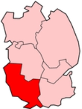
South Kesteven is a local government district
in Lincolnshire
, England
, forming part of the traditional Kesteven
division of the county. It covers Grantham
, Stamford
, Bourne
and Market Deeping
.
 The district was formed on April 1, 1974, under the Local Government Act 1972
, from the municipal borough
s of Grantham and Stamford, along with Bourne Urban district
, South Kesteven Rural District
and West Kesteven Rural District
. Previously the district was run by Kesteven County Council, based in Sleaford
.
In the discussions around 1972 that split off the north of Lindsey
, to become South Humberside
, there were also radical plans to split off the south of Kesteven
to make a county based on Peterborough. Neighbouring Rutland would have also joined, but instead was consumed by Leicestershire
.
to the north, as far east as Horbling
, where the A52
crosses the South Forty-Foot Drain
. From there south it borders South Holland
along the South Forty-Foot Drain, crossing the A151 just west of Guthram Gowt
. The border follows the River Glen
near to Tongue End where at Baston, the boundary crosses north-south over Baston and Langtoft fens. It crosses the A16 at the B1525 junction (the end of the Deepings bypass), then meets the Welland
about two miles west of Crowland
at a point called Kennulph's Stone. The parish of Deeping St. James is the south-east corner of the district, where the district borders the unitary authority of City of Peterborough
. The boundary follows the Welland to Stamford, briefly following the B1443 (Barnack Road) where it skirts the edge of Burghley Park
.
At the point where the railway
crosses under the A1, is the corner of two other districts - Rutland and East Northamptonshire
. The boundary with Rutland follows the east side of the A1. Since 1991, none of the A1 bypass is in South Kesteven. The boundary meets that of Great Casterton
, and briefly follows the B1081 Ermine Street
at Toll Bar. The boundary then follows that of Rutland, crossing the East Coast Main Line at Braceborough and Wilsthorpe
and again at Carlby
. At Castle Bytham
, the boundary follows the east side of the A1, and crosses the A1 at South Witham
, where a little further west is a corner with the district of Melton. The boundary follows that of Leicestershire
along the former Sewstern
Lane, which is now the Viking Way
where it crosses the eastern end of Saltby Airfield
. The boundary deviates from the Viking Way at Woolsthorpe-by-Belvoir
where it briefly follows the River Devon
. It crosses the A52 and railway at Sedgebrook. This area is part of the Vale of Belvoir
. The boundary then passes through the former RAF Bottesford
, where just north it meets the district of Newark and Sherwood
(Staunton) at Three Shire Oak. The boundary crosses the A1 at Shire Bridge. It follows Shire Dyke at Claypole, crossing the East Coast Main Line
, then briefly follows the River Witham
. The north-west corner of the district is on the River Witham at Claypole just south of Barnby in the Willows
. Further east, a two mile section of the A17 skirts the district, just east of Byards Leap
.
A corner of the district is where it meets the former route of Ermine Street
, and now the Viking Way. This is the point where it meets the corners of Cranwell and Byard's Leap, and Temple Bruer with Temple High Grange in North Kesteven. The boundary follows the Viking Way for three miles south, crossing the A17. It follows the B6403 to just north of Ancaster
. It skirts Ancaster then rejoins the B640s south of Ancaster to a point just south of RAF Barkston Heath
. It passes just east of Oasby
, crosses the A52, passes east of Braceby and Sapperton
and Pickworth
, then north of Folkingham. North of Horbling it follows the A52 all the way to Donington High Bridge.
It is interesting to add that, since 1965, the border with Northamptonshire
is Britain's smallest border at only 10 meters. However, the boundary with Rutland was altered in April 1991.
 South Kesteven consists of 34 electoral wards:
Link to all 56 South Kesteven district councillors.
OBE, who represents Folkingham
Rural, in the east of the district. Peter Robinson, who represents Market Deeping and West Deeping, is one of the two Deputy Leaders of the county council. Sue Woolley, who represents Bourne Abbey, is also on the Executive of the county council.
. However, it has the most number of people in the county aged under 19 and between 25-49. It has the most number of university-educated people in the county and the healthiest people. It has the most number of employed people in the county - 61,000. The median age of the district is 39.
The district is the second least-deprived in Lincolnshire, after North Kesteven
. 60% of the district live in the towns. Sixteen of the villages are Local Service Centres. In the 2001 census the district had 58,033 dwellings. For Lower Level Super Output Areas (around 1,500 population), there are 18 in the top 10% least deprived in England; around 30,000 people.
passes north-south through the district just west of Bourne
and the A15.
23% of occupations are in hotel and catering; 23% in public administration, education, and health; and 27% in construction and manufacturing. 18% of companies are in knowledge-based industries, fairly high for the nearby region, but lower than Peterborough or Rutland (both 20%); the UK average is 20%. Although the district has a lower job density (jobs per resident) than the UK average, the relatively low local unemployment rate means many residents work outside the district. This also means that unemployed residents would be better looking for employment outside the district.
Stamford has a presence in the publishing sector, specialising in domestic pets and aviation, helped by the proximity of EMAP
in Orton, Peterborough - a local talent pool to draw on. The main employer in the town is Cummins Generator Technologies. The largest employer in Bourne is the Bourne Prepared Produce site of Bakkavör
, who prepare salads, and stir fry
vegetables.
The district opened its first purpose-built business innovation centre, called Eventus, on the A1175
at Market Deeping in July 2010. This is to attract high-tech companies, which the district notably lacks (as does most of the county), and was funded by the district and county councils. The district has a stable economy. It lies in the Welland Sub Regional Strategic Partnership (Welland SSP), which covers the district apart from Grantham, and has been run by Welland Enterprise (owned by Norfolk and Waveney Enterprise Services) based at Stoke Rochford
. Grantham is covered by Lincolnshire Enterprise. Outside of the main towns, commercial development has been allocated for Colsterworth
and the Roseland Business Park at Long Bennington
on part of the former RAF Bottesford
.
The district forms the northern sector of the Peterborough Sub-Region (formed also with Rutland, South Holland, East Northamptonshire
, Huntingdonshire
and Fenland
). Bourne, Stamford and Market Deeping are in Peterborough's Travel to Work Area
. North of there, Grantham is the next TTWA
. The A15 corridor to Bourne is where most people in the district work in Peterborough. At the 2001 census it was found only 65% of workers work in the district, but 13% go to Peterborough, 3% to Rutland and 2% to North Kesteven. Around 21% of people working in the district live elsewhere - 3% from North Kesteven and Peterborough, and 2% from Rutland. Around 700 people in the district travel to work in London. For neighbouring Rutland, North Kesteven and Newark and Sherwood
, an even lower percentage of residents work in their own district - all are dormitory area
s.
For the district, the daily Peterborough Evening Telegraph
is bought most in Market Deeping
. The daily Lincolnshire Echo
is not sold in most of the district. For the district, the Nottingham Post is sold mostly in Grantham.
youth hostels in the county, which was saved through district and county council intervention.
The district has a 130-mile walk called the South Kesteven Round.
. Both of these contribute to house prices in the area, which are the highest for districts in Lincolnshire. The district has the most dangerous section of road in the county - the A1 at Great Ponton
. The A52
is a busy east west route. The A15 is a quieter route and goes through the centre of many villages.
The Birmingham to Peterborough Line
passes through Stamford, which is an important (and one of the few) east-west route.
). Similar to North Kesteven
and West Lindsey
, the district has a mixture of selective and comprehensive education, depending on which town you go to school in. In 2010 62.3% gained five good GCSEs (West Lindsey - 68%).
Officially, Grantham and Bourne have selective schools and Market Deeping has a comprehensive school. Stamford has never had a grammar school
. The eleven plus exam is sat, but places are provided at the boys' and girls' schools in the town, similar to the former direct grant system
before the late-1970s. The local people were led to believe that Bourne Grammar School would provide sufficient places for high-achieving pupils when the direct-funding scheme was phased out for new entrants in 2011, but circumstances have negated this option. Further afield along the A16, the two single-sex grammar schools in Boston
are under-subscribed and have had proposals to be merged in a federation. The two grammar schools in Spalding
also take many pupils from Peterborough
- outside the county. Much of the displeasure of Stamford's funding situation came from a handful of Labour county councillors - also most of these would have lost their seat in 2009. There are no Labour county councillors for South Kesteven, or for South Holland, North Kesteven, Boston or West Lindsey. Three out of the four current Labour county councillors (from 77 seats available) represent Lincoln.
Overall, results at GCSE in Bourne and Grantham appear to be much better than in Stamford, but it is an unequal comparison for the state sector. The situation is complicated in the south of the district because Bourne Grammar School
(which gets the second best A level results for state schools in the East Midlands), can take a small proportion of pupils from Stamford and Market Deeping - essentially Bourne Grammar School is the most selective school in the district (for those not living near to Bourne), and gets the best A level results in the district. The district attracts affluent home-owners, having the highest house prices of the Lincolnshire districts, because of the (comparatively) excellent education available with plentiful transport links. However, because of the limited scope of work available, the district is more and more becoming a dormitory
for people to work in Nottingham (from Grantham) or Peterborough (all four towns). Both these cities have the quality of work, but not the quality of state schools.
The low-performing Aveland School in Billingborough
confuses admissions in the district as well, because it takes most of its intake from North Kesteven
(villages south of Sleaford
). The school is officially, but not physically, now part of St George's Academy
in Sleaford.
The district has 51 primary schools and 10 state secondary schools. There are 8 independent schools.
closed; the Hall is now the training centre of the NUT
. More recently the district had the Kesteven Agricultural College at Caythorpe Court
, in the north of the district. It was taken over by the newly-formed University of Lincoln
, who prompted closed it one year later in 2002.
Due to neighbouring Rutland
not having a further education college, it relies on New College Stamford. Rutland also shares an Employment and Skills Board, Education Business Partnership
, Connexions (agency), Aimhigher
centre, and learndirect
service (Lincolnshire & Rutland Hub based at Lincoln College
).
Non-metropolitan district
Non-metropolitan districts, or colloquially shire districts, are a type of local government district in England. As created, they are sub-divisions of non-metropolitan counties in a so-called "two-tier" arrangement...
in Lincolnshire
Lincolnshire
Lincolnshire is a county in the east of England. It borders Norfolk to the south east, Cambridgeshire to the south, Rutland to the south west, Leicestershire and Nottinghamshire to the west, South Yorkshire to the north west, and the East Riding of Yorkshire to the north. It also borders...
, England
England
England is a country that is part of the United Kingdom. It shares land borders with Scotland to the north and Wales to the west; the Irish Sea is to the north west, the Celtic Sea to the south west, with the North Sea to the east and the English Channel to the south separating it from continental...
, forming part of the traditional Kesteven
Kesteven
The Parts of Kesteven are a traditional subdivision of Lincolnshire, England. This subdivision had long had a separate county administration , along with the other two parts, Lindsey and Holland.-Etymology:...
division of the county. It covers Grantham
Grantham
Grantham is a market town within the South Kesteven district of Lincolnshire, England. It bestrides the East Coast Main Line railway , the historic A1 main north-south road, and the River Witham. Grantham is located approximately south of the city of Lincoln, and approximately east of Nottingham...
, Stamford
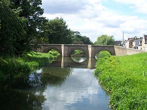
Stamford, Lincolnshire
Stamford is a town and civil parish within the South Kesteven district of the county of Lincolnshire, England. It is approximately to the north of London, on the east side of the A1 road to York and Edinburgh and on the River Welland...
, Bourne
Bourne, Lincolnshire
Bourne is a market town and civil parish on the western edge of the Fens, in the District of South Kesteven in southern Lincolnshire, England.-The town:...
and Market Deeping
Market Deeping
Market Deeping is a market town in Lincolnshire, England, on the north bank of the River Welland and the A15 road.-Geography:It is the second largest of The Deepings and its eponymous market has been held since at least 1220. The river here forms the Lincolnshire/Cambridgeshire border with...
.
History
Local Government Act 1972
The Local Government Act 1972 is an Act of Parliament in the United Kingdom that reformed local government in England and Wales on 1 April 1974....
, from the municipal borough
Municipal borough
Municipal boroughs were a type of local government district which existed in England and Wales between 1835 and 1974, in Northern Ireland from 1840 to 1973 and in the Republic of Ireland from 1840 to 2002...
s of Grantham and Stamford, along with Bourne Urban district
Urban district
In the England, Wales and Ireland, an urban district was a type of local government district that covered an urbanised area. Urban districts had an elected Urban District Council , which shared local government responsibilities with a county council....
, South Kesteven Rural District
South Kesteven Rural District
South Kesteven was a rural district in Lincolnshire, Parts of Kesteven in England from 1931 to 1974.It was formed under a County Review Order in 1931, by the merger of the Bourne Rural District and the Uffington Rural District....
and West Kesteven Rural District
West Kesteven Rural District
West Kesteven was a rural district in Lincolnshire, Parts of Kesteven, England from 1931 to 1974.It was formed under a County Review Order, by the merger of most of the Grantham Rural District, part of the Sleaford Rural District and much of the Claypole Rural District.It was abolished in 1974...
. Previously the district was run by Kesteven County Council, based in Sleaford
Sleaford
Sleaford is a town in the North Kesteven district of Lincolnshire, England. It is located thirteen miles northeast of Grantham, seventeen miles west of Boston, and nineteen miles south of Lincoln, and had a total resident population of around 14,500 in 6,167 households at the time...
.
In the discussions around 1972 that split off the north of Lindsey
Lindsey
Lindsey was a unit of local government until 1974 in Lincolnshire, England, covering the northern part of the county. The Isle of Axholme, which is on the west side of the River Trent, has normally formed part of it...
, to become South Humberside
South Humberside
South Humberside is a former postal county of England. It was introduced by the Royal Mail on 1 July 1974, when some addresses were altered in response to the changes in administration brought about under the Local Government Act 1972....
, there were also radical plans to split off the south of Kesteven
Kesteven
The Parts of Kesteven are a traditional subdivision of Lincolnshire, England. This subdivision had long had a separate county administration , along with the other two parts, Lindsey and Holland.-Etymology:...
to make a county based on Peterborough. Neighbouring Rutland would have also joined, but instead was consumed by Leicestershire
Leicestershire
Leicestershire is a landlocked county in the English Midlands. It takes its name from the heavily populated City of Leicester, traditionally its administrative centre, although the City of Leicester unitary authority is today administered separately from the rest of Leicestershire...
.
Geography
South Kesteven borders North KestevenNorth Kesteven
North Kesteven is a local government district in the East Midlands. Just over north of London, it is east of Nottingham and south of Lincoln. North Kesteven is one of seven districts in Lincolnshire, England and is in the centre of the County...
to the north, as far east as Horbling
Horbling
Horbling is a village which is situated a half mile north of Billingborough, in South Kesteven, in Lincolnshire on the B1777.It contains a church and a scout group. The scout group also serves Billingborough, Horbling and Morton. The church is dedicated to . The village pub is the on Spring Lane...
, where the A52
A52 road
The A52 is a major road in the East Midlands, England. It runs east from the junction with the A53 at Newcastle-under-Lyme near Stoke-on-Trent via Ashbourne, Derby, Stapleford, Nottingham, West Bridgford, Bingham, Grantham, Boston and Skegness before terminating on the east Lincolnshire coast at...
crosses the South Forty-Foot Drain
South Forty-foot drain
The South Forty-Foot Drain is the main channel for the land-drainage of the Black Sluice Level in the Lincolnshire Fens. It lies in eastern England between Guthram Gowt and the Black Sluice pumping station on The Haven, at Boston...
. From there south it borders South Holland
South Holland, Lincolnshire
South Holland is a local government district of Lincolnshire. The district council is based in Spalding.It was formed on 1 April 1974, under the Local Government Act 1972, as a merger of the Spalding urban district with East Elloe Rural District and Spalding Rural District...
along the South Forty-Foot Drain, crossing the A151 just west of Guthram Gowt
Guthram Gowt
Guthram Gowt is a small settlement between Bourne and Spalding in Lincolnshire, England, at a bend in the River Glen.-The Location:Guthram Gowt is at the southern, upstream end of the South Forty-Foot Drain...
. The border follows the River Glen
River Glen, Lincolnshire
The River Glen is a river in Lincolnshire, England with a short stretch passing through Rutland near Essendine.The river's name appears to derive from a Brythonic Celtic language but there is a strong early English connection.-Naming:...
near to Tongue End where at Baston, the boundary crosses north-south over Baston and Langtoft fens. It crosses the A16 at the B1525 junction (the end of the Deepings bypass), then meets the Welland
River Welland
The River Welland is a river in the east of England, some long. It rises in the Hothorpe Hills, at Sibbertoft in Northamptonshire, then flows generally northeast to Market Harborough, Stamford and Spalding, to reach The Wash near Fosdyke. For much of its length it forms the county boundary between...
about two miles west of Crowland
Crowland
Crowland or Croyland is a small town in south Lincolnshire, England, positioned between Peterborough and Spalding, with two sites of historical interest.-Geography:...
at a point called Kennulph's Stone. The parish of Deeping St. James is the south-east corner of the district, where the district borders the unitary authority of City of Peterborough
Peterborough
Peterborough is a cathedral city and unitary authority area in the East of England, with an estimated population of in June 2007. For ceremonial purposes it is in the county of Cambridgeshire. Situated north of London, the city stands on the River Nene which flows into the North Sea...
. The boundary follows the Welland to Stamford, briefly following the B1443 (Barnack Road) where it skirts the edge of Burghley Park
Burghley House
Burghley House is a grand 16th-century country house near the town of Stamford, Lincolnshire, England...
.
At the point where the railway
Birmingham to Peterborough Line
The Birmingham to Peterborough Line is a cross-country railway line in the United Kingdom, linking Birmingham to Peterborough, via Nuneaton and Leicester....
crosses under the A1, is the corner of two other districts - Rutland and East Northamptonshire
East Northamptonshire
East Northamptonshire is a local government district in Northamptonshire, England. Its council is based in Thrapston and Rushden, which is the largest town in the area...
. The boundary with Rutland follows the east side of the A1. Since 1991, none of the A1 bypass is in South Kesteven. The boundary meets that of Great Casterton
Great Casterton
Great Casterton is a village and civil parish in the county of Rutland in the East Midlands of England. It is located at the crossing of the Roman Ermine Street and the River Gwash.-Geography:...
, and briefly follows the B1081 Ermine Street
Ermine Street
Ermine Street is the name of a major Roman road in England that ran from London to Lincoln and York . The Old English name was 'Earninga Straete' , named after a tribe called the Earningas, who inhabited a district later known as Armingford Hundred, around Arrington, Cambridgeshire and Royston,...
at Toll Bar. The boundary then follows that of Rutland, crossing the East Coast Main Line at Braceborough and Wilsthorpe
Braceborough and Wilsthorpe
Braceborough and Wilsthorpe is a civil parish in the South Kesteven district of Lincolnshire, England. According to the 2001 census it had a population of 268. The parish covers Braceborough and Wilsthorpe....
and again at Carlby
Carlby
Carlby is a small village/parish in the district of South Kesteven in Lincolnshire, England.It is located four miles south of Bourne on the A6121 near the Lincolnshire/Rutland boundary, which is partly the River West Glen....
. At Castle Bytham
Castle Bytham
Castle Bytham is a picturesque village and Civil Parish of around 300 houses in South Kesteven in south Lincolnshire.At one time the village was an important commercial centre for the surrounding agricultural communities, but it is now largely a dormitory, although a number of farming families...
, the boundary follows the east side of the A1, and crosses the A1 at South Witham
South Witham
South Witham is a village in South Kesteven, Lincolnshire, situated close to the Leicestershire and Rutland borders.-Geography:It is bisected by the young River Witham, about three miles to the east of its source. It is the point on the A1 where it enters Lincolnshire from the south, near ...
, where a little further west is a corner with the district of Melton. The boundary follows that of Leicestershire
Leicestershire
Leicestershire is a landlocked county in the English Midlands. It takes its name from the heavily populated City of Leicester, traditionally its administrative centre, although the City of Leicester unitary authority is today administered separately from the rest of Leicestershire...
along the former Sewstern
Sewstern
Sewstern is a village in the Melton district of east Leicestershire.It lies just south of Buckminster, with which it shares a , situated between the two villages, and a parish council...
Lane, which is now the Viking Way
Viking Way
The Viking Way is a long distance footpath in England running between the Humber Bridge in North Lincolnshire and Oakham in Rutland. The Countryside Commission recognised the significance of the Viking Way as a high quality long distance walk linking other major routes in Eastern England, these...
where it crosses the eastern end of Saltby Airfield
RAF Saltby
RAF Station Saltby was a World War II airfield in Leicestershire, England. The airfield is located approximately northeast of Melton Mowbray; about north-northwestof London....
. The boundary deviates from the Viking Way at Woolsthorpe-by-Belvoir
Woolsthorpe-by-Belvoir
Woolsthorpe, also known as Woolsthorpe-by-Belvoir, is a small village in the English county of Lincolnshire, about 5 miles from the town of Grantham...
where it briefly follows the River Devon
River Devon, Nottinghamshire
The River Devon is a tributary of the River Trent, which rises in Leicestershire and joins the Trent at Newark in Nottinghamshire, England. In its upper reaches, it supplies Knipton Reservoir, which was built to supply water to the Grantham Canal, and Belvoir Lakes, designed by Capability Brown...
. It crosses the A52 and railway at Sedgebrook. This area is part of the Vale of Belvoir
Vale of Belvoir
The Vale of Belvoir is an area of natural beauty on the borders of Leicestershire, Nottinghamshire and Lincolnshire in England. Indeed, the name itself derives from the Norman-French for beautiful view.-Extent and geology:...
. The boundary then passes through the former RAF Bottesford
RAF Bottesford
RAF Station Bottesford is a former World War II airfield on the Leicestershire-Lincolnshire county border in England. The airfield is located approximately east-northeast of Radcliffe on Trent; about north-northwest of London...
, where just north it meets the district of Newark and Sherwood
Newark and Sherwood
Newark and Sherwood is a local government district of eastern Nottinghamshire, England. The district is predominantly rural, with some large forestry plantations, and the towns of Newark-on-Trent, Southwell and Ollerton....
(Staunton) at Three Shire Oak. The boundary crosses the A1 at Shire Bridge. It follows Shire Dyke at Claypole, crossing the East Coast Main Line
East Coast Main Line
The East Coast Main Line is a long electrified high-speed railway link between London, Peterborough, Doncaster, Wakefield, Leeds, York, Darlington, Newcastle and Edinburgh...
, then briefly follows the River Witham
River Witham
The River Witham is a river, almost entirely in the county of Lincolnshire, in the east of England. It rises south of Grantham close to South Witham, at SK8818, passes Lincoln at SK9771 and at Boston, TF3244, flows into The Haven, a tidal arm of The Wash, near RSPB Frampton Marsh...
. The north-west corner of the district is on the River Witham at Claypole just south of Barnby in the Willows
Barnby in the Willows
Barnby in the Willows is a village and civil parish in the Newark and Sherwood district of Nottinghamshire, England, just east of Newark-on-Trent. According to the 2001 census it had a population of 244...
. Further east, a two mile section of the A17 skirts the district, just east of Byards Leap
Byards Leap
Byard's Leap is a hamlet in the North Kesteven district of Lincolnshire, England, and lies 3 miles west of Cranwell. It is part of the civil parish of Cranwell and Byard's Leap. The hamlet is associated with various legends....
.
A corner of the district is where it meets the former route of Ermine Street
Ermine Street
Ermine Street is the name of a major Roman road in England that ran from London to Lincoln and York . The Old English name was 'Earninga Straete' , named after a tribe called the Earningas, who inhabited a district later known as Armingford Hundred, around Arrington, Cambridgeshire and Royston,...
, and now the Viking Way. This is the point where it meets the corners of Cranwell and Byard's Leap, and Temple Bruer with Temple High Grange in North Kesteven. The boundary follows the Viking Way for three miles south, crossing the A17. It follows the B6403 to just north of Ancaster
Ancaster, Lincolnshire
Ancaster is a village in the South Kesteven district of Lincolnshire, England, on the site of the Roman town of "Causennae"Ancaster Hall at The University of Nottingham is named after the parish and the, now extinct, title of the Earl of Ancaster....
. It skirts Ancaster then rejoins the B640s south of Ancaster to a point just south of RAF Barkston Heath
RAF Barkston Heath
RAF Barkston Heath is a Royal Air Force station near Grantham, Lincolnshire.RAF Barkston Heath is the home of the Defence Elementary Flying Training School which, for a period between approximately 1995-2010 operated the Slingsby T67M260 Firefly two seat trainer. The school now operates the Grob...
. It passes just east of Oasby
Oasby
Oasby is a hamlet in the civil parish of Heydour, South Kesteven, Lincolnshire, England. It lies north-east of Grantham.Oasby, Heydour, Aisby, Culverthorpe and Kelby are the five hamlets within Heydour parish....
, crosses the A52, passes east of Braceby and Sapperton
Braceby and Sapperton
Braceby and Sapperton is a civil parish in the South Kesteven district of Lincolnshire, England. According to the 2001 census it had a population of 47. The parish consists of Braceby and Sapperton....
and Pickworth
Pickworth, Lincolnshire
Pickworth is a civil parish and village in the South Kesteven district of Lincolnshire, England.Pickworth was mentioned in Domesday Book of 1086 when it had forty households and a church....
, then north of Folkingham. North of Horbling it follows the A52 all the way to Donington High Bridge.
It is interesting to add that, since 1965, the border with Northamptonshire
Northamptonshire
Northamptonshire is a landlocked county in the English East Midlands, with a population of 629,676 as at the 2001 census. It has boundaries with the ceremonial counties of Warwickshire to the west, Leicestershire and Rutland to the north, Cambridgeshire to the east, Bedfordshire to the south-east,...
is Britain's smallest border at only 10 meters. However, the boundary with Rutland was altered in April 1991.
Electoral wards
- All Saints (Stamford)
- Aveland
- Barrowby
- Belmont
- Bourne East
- Bourne West
- Deeping St James
- Earlesfield (Grantham)
- Ermine
- Forest
- Glen Eden
- Grantham St Johns
- Green Hill
- Greyfriars
- Harrowby
- Heath
- Hillsides
- Isaac Newton
- Lincrest
- Loveden
- Market and West Deeping
- Morkery
- Peascliffe
- Ringstone
- Saxonwell
- St. Annes
- St. George's
- St. Mary's
- St. Wulfram's
- Stamford St John's
- Thurlby
- Toller
- Truesdale
- Witham Valley
Link to all 56 South Kesteven district councillors.
Civil parishes in South Kesteven
- AllingtonAllington, LincolnshireAllington is a village and civil parish in the South Kesteven district of Lincolnshire, England, five miles north-west of Grantham. At the time of the Norman conquest the name of the village was Adelinctune. The 2001 census gave a population of 728 for the parish.Allington Grade II listed Anglican...
- AncasterAncaster, LincolnshireAncaster is a village in the South Kesteven district of Lincolnshire, England, on the site of the Roman town of "Causennae"Ancaster Hall at The University of Nottingham is named after the parish and the, now extinct, title of the Earl of Ancaster....
- Aslackby and LaughtonAslackby and LaughtonAslackby and Laughton is a civil parish in the South Kesteven district of Lincolnshire, England. According to the 2001 census the parish had a population of 243...
(link) - Barholm and StoweBarholm and StoweBarholm and Stowe is a civil parish in the South Kesteven district of Lincolnshire, England. According to the 2001 census it had a population of 87...
(link) - BarkstonBarkstonBarkston is a small village and civil parish lying on the A607 three miles north of Grantham in Lincolnshire, England, just south of the junction with the A153 .-Geography:...
- BarrowbyBarrowbyBarrowby is a large village and Civil Parish lying just to the west of Grantham, in the South Kesteven district of Lincolnshire, England, separated from that town by the main A1 road...
- BastonBastonBaston is a parish on the edge of The Fens and in the administrative district of South Kesteven, Lincolnshire, England. Like most fen-edge parishes, it was laid out more than a thousand years ago, in an elongated form, to afford the produce from a variety of habitats for the villagers...
(link) - Belton and ManthorpeBelton, LincolnshireBelton is a village in the civil parish of Belton and Manthorpe, in the South Kesteven district of Lincolnshire, England. It lies north of Grantham, on the A607 road.The Saxon meaning of Belton is a bell-shaped hollow.-The Village:...
- BillingboroughBillingboroughBillingborough is a village and civil parish in the South Kesteven district of Lincolnshire, England, about ten miles north of Bourne and ten miles south of Sleaford on the B1177 between Horbling and Pointon just south of the A52.-Village:...
(link) - Bitchfield and BassingthorpeBitchfield and BassingthorpeBitchfield and Bassingthorpe is a village and civil parish in the South Kesteven district of Lincolnshire, England. According to the 2001 census it had a population of 154. The parish includes Bitchfield and Bassingthorpe....
- Boothby PagnellBoothby PagnellBoothby Pagnell is a village and civil parish in the South Kesteven district of Lincolnshire, England.-Parish:The local authority, and the Ordnance Survey, spell the village Boothby Pagnell. The Diocese of Lincoln spells the PCC as Boothby Pagnall. The ecclesiastical parish is part of The North...
- BourneBourne, LincolnshireBourne is a market town and civil parish on the western edge of the Fens, in the District of South Kesteven in southern Lincolnshire, England.-The town:...
(link) - Braceborough and WilsthorpeBraceborough and WilsthorpeBraceborough and Wilsthorpe is a civil parish in the South Kesteven district of Lincolnshire, England. According to the 2001 census it had a population of 268. The parish covers Braceborough and Wilsthorpe....
(link to Braceborough) (link to Wilsthorpe) - Braceby and SappertonBraceby and SappertonBraceby and Sapperton is a civil parish in the South Kesteven district of Lincolnshire, England. According to the 2001 census it had a population of 47. The parish consists of Braceby and Sapperton....
(link) - Burton CogglesBurton CogglesBurton Coggles is a small village and civil parish located south of Grantham in the South Kesteven district of Lincolnshire, England...
- Careby Aunby and HolywellCareby Aunby and HolywellCareby Aunby and Holywell is a civil parish in the district of South Kesteven, south-west Lincolnshire, in England. It stretches from the county border with Rutland in the west to the River West Glen in the east. The B1176 road from Corby Glen passes through Careby and on past Aunby toward...
(link to Careby) (link to Holywell) - CarlbyCarlbyCarlby is a small village/parish in the district of South Kesteven in Lincolnshire, England.It is located four miles south of Bourne on the A6121 near the Lincolnshire/Rutland boundary, which is partly the River West Glen....
(link) - Carlton ScroopCarlton ScroopCarlton Scroop is a small village and civil parish in the South Kesteven district of Lincolnshire, England. It lies 6 miles north-east of Grantham, 4 miles east of Hougham, 2 miles east of Ancaster and 1 mile south of Normanton...
- Castle BythamCastle BythamCastle Bytham is a picturesque village and Civil Parish of around 300 houses in South Kesteven in south Lincolnshire.At one time the village was an important commercial centre for the surrounding agricultural communities, but it is now largely a dormitory, although a number of farming families...
(link) - CawthorpeCawthorpeCawthorpe is a hamlet in the civil parish of Bourne, in the South Kesteven district of Lincolnshire, England.Cawthorpe holds four Grade II listed buildings: Cawthorpe Hall, Cawthorpe House, Ivy Nook cottage, and an 18th century farmhouse.-External links:...
- CaythorpeCaythorpe, LincolnshireCaythorpe is a large village and civil parish in the South Kesteven district of Lincolnshire, England. It lies on the A607, 5 miles south from Leadenham and 8 miles north from Grantham. Caythorpe Heath stretches east of the village to Ermine Street and Byards Leap.-Village:Caythorpe Grade I listed...
- Claypole
- ColsterworthColsterworthColsterworth is a village and civil parish in the South Kesteven district of Lincolnshire, England. The village, together with the hamlet of Woolsthorpe-by-Colsterworth, had a population of 1,508 according to the 2001 census. It lies half a mile to the west of the A1, seven miles south of Grantham...
- Corby GlenCorby GlenCorby Glen is a village in southwest Lincolnshire, England.-Geography:The village of Corby Glen is in South Kesteven District in Lincolnshire. It lies mainly to the north of the A151, a former toll road, and to the east of the West Glen River, near where the Glen flows through a small graben in...
(link) - Counthorpe and CreetonCreetonCreeton is a hamlet in the civil parish of Counthorpe and Creeton in the South Kesteven district of Lincolnshire, England. It lies 5 miles south west from Bourne and 3 miles south from Corby Glen, on the River Glen...
(link) - Deeping St JamesDeeping St JamesDeeping St James is a large village in Lincolnshire, England.-Geography:Deeping St James lies east of Market Deeping on the River Welland, in the middle of rich sedimentary agricultural land on the B1166 and B1162 roads. With a population of 6,923 in 2837 households, it is the largest of The...
(link) - DentonDenton, LincolnshireDenton, Lincolnshire, England, is an ancient Roman settlement south west of Grantham and west of the A1. It may also be a site of the Beaker culture, based on some archeological finds made. The parish is around 2,600 acres in size...
- DowsbyDowsbyDowsby is a village and civil parish in the South Kesteven district of Lincolnshire, England. It lies on the western edge of The Fens at the junction of the east-west B1397 road and the north-south B1177. It is north-east of Rippingale and just south of Pointon. The civil parish includes the...
(link) - DunsbyDunsbyDunsby is a small village and civil parish in the South Kesteven district of in Lincolnshire, England. It lies miles north from Bourne, just off the A15 on the western edge of the Lincolnshire Fens. In 2001 it has a population of 141....
(link) - EastonEaston, LincolnshireEaston is a village and civil parish in the South Kesteven district of Lincolnshire, England. It lies just off the A1, north of Woolsthorpe-by-Colsterworth and Colsterworth.-Geography:...
- EdenhamEdenhamEdenham is a village in Lincolnshire, England situated about north-west of Bourne on the A151. The village is part of the civil parish of Edenham Grimsthorpe Elsthorpe & Scottlethorpe.-The Village:...
(link to Edenham) link to Grimscastle) - Fenton
- FolkinghamFolkinghamFolkingham is a village and civil parish at the northern edge of the South Kesteven district of Lincolnshire, England. It lies on the A15 road of north of Bourne. The civil parish and ecclesiastical parish have the same boundaries. The 2001 census recorded a population of 729.-Village:The village...
(link) - FostonFoston, LincolnshireFoston is a small village and civil parish in the South Kesteven district of Lincolnshire, England. It is situated northwest of Grantham, just off the A1....
- FulbeckFulbeckFulbeck is a small village and civil parish in the South Kesteven district of Lincolnshire, England. It lies on the A607, north from Grantham and north-west from Sleaford. To the north is Leadenham, and to the south is Caythorpe.-Toponymy:...
- Great GonerbyGreat GonerbyGreat Gonerby is a village and civil parish in the South Kesteven district of Lincolnshire, England. It lies less than north from Grantham. To its north is the A1 and Gonerby Moor...
- Great PontonGreat PontonGreat Ponton is a village and civil parish in the South Kesteven district of Lincolnshire, England. In the 2001 census, the population of the village was 100% white ethnic origin, and 87% Christian.-Geography:...
- GreatfordGreatfordGreatford is a village and civil parish in the South Kesteven district of Lincolnshire, England. It lies west of the A15, north-east of Stamford, and south of Bourne...
(link) - GunbyGunby, South KestevenGunby is a hamlet of around 30 houses in the South Kesteven district of Lincolnshire, England.Gunby is located close to the borders with Leicestershire and Rutland. The closest town is Grantham although it is within of Oakham and Stamford. To the is North Witham, to the north Stainby and to the ...
and StainbyStainbyStainby is a small hamlet of around 30 houses located in south west Lincolnshire in the district of South Kesteven. It is only a very short distance to the border with Leicestershire .... - HaconbyHaconbyHaconby is a village and civil parish in the South Kesteven district of Lincolnshire, England. It lies on the western edge of the Lincolnshire Fens, north from Bourne-Geography:...
(link to Haconby) (link to Stainfield) - HarlaxtonHarlaxtonHarlaxton is a village and civil parish in the South Kesteven district of Lincolnshire, England. It lies on the edge of the Vale of Belvoir and just off the A607, south-east from Grantham and north-east from Melton Mowbray.-History:...
- HeydourHeydourHeydour is a hamlet and civil parish in the South Kesteven district of Lincolnshire, England. It is south-west from Sleaford and north-east from Grantham...
- HoningtonHonington, LincolnshireHonington is a village and civil parish in the English county of Lincolnshire.Although not on either road Honington lies near to the junction of the A153 and A607 roads about 5½ miles north of the town of Grantham...
- HorblingHorblingHorbling is a village which is situated a half mile north of Billingborough, in South Kesteven, in Lincolnshire on the B1777.It contains a church and a scout group. The scout group also serves Billingborough, Horbling and Morton. The church is dedicated to . The village pub is the on Spring Lane...
- Hough-on-the-HillHough-on-the-HillHough-on-the-Hill lies approximately seven miles due north of Grantham in the South Kesteven district of Lincolnshire, England. The village is on a commanding rise, hence the name. The name Hough is Old English haga, or 'enclosure'....
- HoughamHougham, LincolnshireHougham is a village and civil parish in the South Kesteven district of Lincolnshire, England. It once had its own Hougham railway station on the line between Grantham and Newark...
- IngoldsbyIngoldsbyIngoldsby is a small village of approximately 121 households, located seven miles south east of Grantham, in South Kesteven, Lincolnshire.-Parish:...
- IrnhamIrnhamIrnham is a village in Lincolnshire in South Kesteven, Lincolnshire, England. It is about ten miles south east of Grantham, To the north is Osgodby, to the south Swinstead, and to the west Corby Glen. The village is on a high limestone ridge that forms the southern part of the Lincolnshire...
(link) - Kirkby UnderwoodKirkby UnderwoodKirkby Underwood is a village of 80 households located around four miles north of Bourne in southern Lincolnshire, in the district of South Kesteven....
(link) - LangtoftLangtoft, LincolnshireLangtoft is a village and civil parish in Lincolnshire on the A15 road, about ten miles north of Peterborough and about eight miles east of Stamford, Lincolnshire on the edge of The Fens....
(link) - Lenton Keisby and Osgodby (link to Lenton) (link to Keisby)
- Little BythamLittle BythamLittle Bytham is a small village in South Kesteven in south Lincolnshire, situated between Corby Glen and Stamford on the B1176, which is straddled by brick railway viaducts of the East Coast Main Line as the road passes through the village.On the edge of the village to the east is the West Glen...
(link) - Little PontonLittle PontonLittle Ponton is a small village just south of Grantham in South Kesteven. Lincolnshire.-Geography:It is part of the civil parish of Little Ponton and Stroxton. It is situated just off the B1174 ....
and StroxtonStroxtonStroxton is a settlement of 15 households located three miles south of Grantham in South Kesteven, Lincolnshire, England.It is around half a mile from the A1 and can be reached by a bridge which spans the A1. Directly east is Little Ponton. The parish church is dedicated to All Saints. -External... - Londonthorpe and Harrowby Without
- Long BenningtonLong BenningtonLong Bennington is a village in South Kesteven, south Lincolnshire, England. It is equidistant from Newark-on-Trent and Grantham, and from the villages of Stubton and Orston. It has a population of 1,847.-Geography:...
- Market DeepingMarket DeepingMarket Deeping is a market town in Lincolnshire, England, on the north bank of the River Welland and the A15 road.-Geography:It is the second largest of The Deepings and its eponymous market has been held since at least 1220. The river here forms the Lincolnshire/Cambridgeshire border with...
(link) - MarstonMarston, LincolnshireMarston is a village in Lincolnshire, England, just north of the A1 near Long Bennington.There is a church dedicated to St Mary, a Hall , a Fishery Marston is a village in Lincolnshire, England, just north of the A1 near Long Bennington.There is a church dedicated to St Mary, a Hall (Marston Hall),...
- Morton and HanthorpeMorton and HanthorpeMorton and Hanthorpe is a civil parish, formerly known as Morton by Bourne in the South Kesteven district of Lincolnshire, England. There are other villages and hamlets in the county with the name of Morton. There are 921 households in Morton and 74 in Hanthorpe.Morton Grade I listed Anglican...
(link) - NormantonNormanton, LincolnshireNormanton, sometimes called Normanton on Cliffe, is a village and civil parish on the A607 about north of the town of Grantham and south of the city of Lincoln, in the South Kesteven district of Lincolnshire, England....
- North WithamNorth WithamNorth Witham is a small village and civil parish in South Kesteven, Lincolnshire, England. The village is located along the upper course of the River Witham, 11.4 miles south of the nearest major town, Grantham. It has an estimated population of 158 in around 70 households...
- Old SomerbyOld SomerbyOld Somerby is situated three miles east of the town of Grantham in southern Lincolnshire in South Kesteven. It is situated on the B1176 approximately 1 mile from its junction with the A52 and B6403 and 250 metres from the East Coast Main Line....
- PickworthPickworth, LincolnshirePickworth is a civil parish and village in the South Kesteven district of Lincolnshire, England.Pickworth was mentioned in Domesday Book of 1086 when it had forty households and a church....
(link) - Pointon and Sempringham (link to Pointon) (link to Sempringham)
- RippingaleRippingaleRippingale is a village in Lincolnshire, England on the A15 road about 5 miles north of Bourne. Its local government district is South Kesteven. Rippingale is a civil parish and an ecclesiastical parish in the Aveland Deanery of the Diocese of Lincoln....
(link) - Ropsley and Humby
- Sedgebrook
- SkillingtonSkillingtonSkillington is a rural village, located to the south-west of Lincolnshire and is within three miles of the Leicestershire border. Nearby villages include Buckminster, Sproxton, Stainby, Sewstern, Colsterworth and Woolsthorpe-by-Colsterworth, with the latter famous as the birthplace of Sir Isaac...
- South WithamSouth WithamSouth Witham is a village in South Kesteven, Lincolnshire, situated close to the Leicestershire and Rutland borders.-Geography:It is bisected by the young River Witham, about three miles to the east of its source. It is the point on the A1 where it enters Lincolnshire from the south, near ...
- StamfordStamford, LincolnshireStamford is a town and civil parish within the South Kesteven district of the county of Lincolnshire, England. It is approximately to the north of London, on the east side of the A1 road to York and Edinburgh and on the River Welland...
- Stoke RochfordStoke RochfordStoke Rochford is a small village near Grantham in Lincolnshire.-Geography:For administration purposes, the parish is shared with Easton, which also has a country estate of its own. Stoke Rochford's church is in the parish of Easton, and so is the post office. The southern boundary of the parish...
- StubtonStubtonStubton is a small village and civil parish in the South Kesteven district of Lincolnshire, England. The nearest town is Newark-on-Trent in Nottinghamshire, which is 7 miles away.Adjacent villages include Claypole, Dry Doddington, Beckingham and Brandon....
- SwayfieldSwayfieldSwayfield is a small village of approximately 138 houses situated just off the A1 in South Kesteven, southern Lincolnshire, England.-The Village:...
(link) - SwinsteadSwinsteadSwinstead is a small village of just over 100 households, located 5 miles west of Bourne in southern Lincolnshire. Although close to Bourne and Stamford , it lies in the Grantham post code....
(link) - SystonSyston, LincolnshireSyston is a small hamlet and civil parish located 3 miles north of Grantham on the A607 road which runs to the county town of Lincoln. Syston is linked onto the larger village of Barkston....
- TallingtonTallingtonTallington is a small village of around 200 houses, situated four miles east of Stamford in South Kesteven, on the southern edge of Lincolnshire, next to the borough of Peterborough.-Geography:...
(link) - ThurlbyThurlby by BourneThurlby is a village and civil parish in the District of South Kesteven in the English county of Lincolnshire, on the edge of The Fens. It is sometimes referred to as Thurlby by Bourne to distinguish it from other villages in Lincolnshire called Thurlby...
(link) - Toft with LoundToft, LincolnshireToft is a small village in Lincolnshire, England situated about three miles south-west of Bourne on the A6121. It is part of the Parish of Toft with Lound and Manthorpe....
and ManthorpeManthorpe, BourneManthorpe is a small in South Kesteven in Lincolnshire.It is situated about two miles west of Thurlby and three miles south-west along the A6121 from Bourne. A mile to the west is Witham on the Hill....
(link to Manthorpe) (link to Toft) - UffingtonUffington, LincolnshireUffington is a village in the valley of the River Welland, between Stamford and The Deepings, in the South Kesteven district of the English county of Lincolnshire.-Geography:...
- WelbyWelby, LincolnshireWelby is a village and civil parish in the South Kesteven district of Lincolnshire, England. It lies north-east of Grantham, and east of the old Roman Road Ermine Street. Neighbouring villages are Aisby, Oasby, and Heydour. The village has approximately 75 houses.Welby Grade I listed Anglican...
- West DeepingWest DeepingWest Deeping is a village in Lincolnshire, England that forms part of The Deepings, lying just off the A16 road towards Stamford to the west of Market Deeping, hence its name West Deeping. It has a population of 277. It is a Civil Parish in South Kesteven....
(link) - Westborough and Dry Doddington
- Witham on the HillWitham on the HillWitham on the Hill is a in the civil parish of the same name, in the South Kesteven district of Lincolnshire, England.-Geography:The village is between the and west tributaries of the River Glen, and despite its name, is not on the top of its 'hill', which reaches a peak one mile west towards...
(link) - Woolsthorpe-by-BelvoirWoolsthorpe-by-BelvoirWoolsthorpe, also known as Woolsthorpe-by-Belvoir, is a small village in the English county of Lincolnshire, about 5 miles from the town of Grantham...
- Wyville cum Hungerton
Local area forums
The district council organizes six Local Area Forums (formerly called Local Area Assemblies) which are designed as a medium by which county, district and town/parish councillors, together with local officials, consult the public in the relevant parts of the district.Representation
Although Lincolnshire County Council, and its funding, is often weighted towards the Greater Lincoln area, the Leader of the county council is Martin HillMartin Hill (councillor)
Martin John Hill OBE is the Leader of Lincolnshire County Council.Hill was born in Leicester. He was brought up in Lincolnshire, near Grimsby.-Career:...
OBE, who represents Folkingham
Folkingham
Folkingham is a village and civil parish at the northern edge of the South Kesteven district of Lincolnshire, England. It lies on the A15 road of north of Bourne. The civil parish and ecclesiastical parish have the same boundaries. The 2001 census recorded a population of 729.-Village:The village...
Rural, in the east of the district. Peter Robinson, who represents Market Deeping and West Deeping, is one of the two Deputy Leaders of the county council. Sue Woolley, who represents Bourne Abbey, is also on the Executive of the county council.
Demographics
There were 124,788 citizens in the district at the 2001 census; it is the second largest district in Lincolnshire by population after East LindseyEast Lindsey
East Lindsey is a local government district in Lincolnshire, England. The council is based in Manby near Louth, and other major settlements in the district include Alford, Spilsby, Mablethorpe, Skegness, Horncastle and Chapel St Leonards....
. However, it has the most number of people in the county aged under 19 and between 25-49. It has the most number of university-educated people in the county and the healthiest people. It has the most number of employed people in the county - 61,000. The median age of the district is 39.
The district is the second least-deprived in Lincolnshire, after North Kesteven
North Kesteven
North Kesteven is a local government district in the East Midlands. Just over north of London, it is east of Nottingham and south of Lincoln. North Kesteven is one of seven districts in Lincolnshire, England and is in the centre of the County...
. 60% of the district live in the towns. Sixteen of the villages are Local Service Centres. In the 2001 census the district had 58,033 dwellings. For Lower Level Super Output Areas (around 1,500 population), there are 18 in the top 10% least deprived in England; around 30,000 people.
Economy
Farming is the main rural industry. The National Transmission SystemNational Transmission System
The National Transmission System is the network of large-diameter gas pipelines throughout the United Kingdom that supply gas to 40 power stations from natural gas terminals situated on the coast, and also gas distribution companies which lead indirectly to homes.-Similarity to the National...
passes north-south through the district just west of Bourne
Bourne, Lincolnshire
Bourne is a market town and civil parish on the western edge of the Fens, in the District of South Kesteven in southern Lincolnshire, England.-The town:...
and the A15.
23% of occupations are in hotel and catering; 23% in public administration, education, and health; and 27% in construction and manufacturing. 18% of companies are in knowledge-based industries, fairly high for the nearby region, but lower than Peterborough or Rutland (both 20%); the UK average is 20%. Although the district has a lower job density (jobs per resident) than the UK average, the relatively low local unemployment rate means many residents work outside the district. This also means that unemployed residents would be better looking for employment outside the district.
Stamford has a presence in the publishing sector, specialising in domestic pets and aviation, helped by the proximity of EMAP
EMAP
Emap Limited is a British media company, specialising in the production of business-to-business magazines, and the organisation of business events and conferences...
in Orton, Peterborough - a local talent pool to draw on. The main employer in the town is Cummins Generator Technologies. The largest employer in Bourne is the Bourne Prepared Produce site of Bakkavör
Bakkavör
Bakkavör Group hf. is an Icelandic international food manufacturing company specialising in fresh prepared foods and produce. The group operates 66 factories and employs over 20,000 people in nine countries with a pro-forma turnover in 2007 of £1.5 billion. The group’s head office is in Reykjavík...
, who prepare salads, and stir fry
Stir frying
Stir frying is an umbrella term used to describe two Chinese cooking techniques for preparing food in a wok: chǎo and bào . The term stir-fry was introduced into the English language by Buwei Yang Chao, in her book How to Cook and Eat in Chinese, to describe the chǎo technique...
vegetables.
The district opened its first purpose-built business innovation centre, called Eventus, on the A1175
A1175 road
The A1175 road is a public highway in south-west Lincolnshire, England within the United Kingdom.It was previously designated as the southern section of the A16, but is being re-classified as the A1175 in early August 2010 following the completion of the new Peterborough to Spalding A16 section.The...
at Market Deeping in July 2010. This is to attract high-tech companies, which the district notably lacks (as does most of the county), and was funded by the district and county councils. The district has a stable economy. It lies in the Welland Sub Regional Strategic Partnership (Welland SSP), which covers the district apart from Grantham, and has been run by Welland Enterprise (owned by Norfolk and Waveney Enterprise Services) based at Stoke Rochford
Stoke Rochford
Stoke Rochford is a small village near Grantham in Lincolnshire.-Geography:For administration purposes, the parish is shared with Easton, which also has a country estate of its own. Stoke Rochford's church is in the parish of Easton, and so is the post office. The southern boundary of the parish...
. Grantham is covered by Lincolnshire Enterprise. Outside of the main towns, commercial development has been allocated for Colsterworth
Colsterworth
Colsterworth is a village and civil parish in the South Kesteven district of Lincolnshire, England. The village, together with the hamlet of Woolsthorpe-by-Colsterworth, had a population of 1,508 according to the 2001 census. It lies half a mile to the west of the A1, seven miles south of Grantham...
and the Roseland Business Park at Long Bennington
Long Bennington
Long Bennington is a village in South Kesteven, south Lincolnshire, England. It is equidistant from Newark-on-Trent and Grantham, and from the villages of Stubton and Orston. It has a population of 1,847.-Geography:...
on part of the former RAF Bottesford
RAF Bottesford
RAF Station Bottesford is a former World War II airfield on the Leicestershire-Lincolnshire county border in England. The airfield is located approximately east-northeast of Radcliffe on Trent; about north-northwest of London...
.
The district forms the northern sector of the Peterborough Sub-Region (formed also with Rutland, South Holland, East Northamptonshire
East Northamptonshire
East Northamptonshire is a local government district in Northamptonshire, England. Its council is based in Thrapston and Rushden, which is the largest town in the area...
, Huntingdonshire
Huntingdonshire
Huntingdonshire is a local government district of Cambridgeshire, covering the area around Huntingdon. Traditionally it is a county in its own right...
and Fenland
Fenland
Fenland is a local government district in Cambridgeshire, England. Its council is based in March, and covers the neighbouring market towns of Chatteris, Whittlesey, and Wisbech, often called the "capital of the fens"...
). Bourne, Stamford and Market Deeping are in Peterborough's Travel to Work Area
Travel to Work Area
A Travel to Work Area or TTWA is a statistical tool used by UK Government agencies and local authorities, especially by the Department for Work and Pensions and Job Centres, to indicate an area where the population would generally commute to a larger town, city or conurbation for the purposes of...
. North of there, Grantham is the next TTWA
Travel to Work Area
A Travel to Work Area or TTWA is a statistical tool used by UK Government agencies and local authorities, especially by the Department for Work and Pensions and Job Centres, to indicate an area where the population would generally commute to a larger town, city or conurbation for the purposes of...
. The A15 corridor to Bourne is where most people in the district work in Peterborough. At the 2001 census it was found only 65% of workers work in the district, but 13% go to Peterborough, 3% to Rutland and 2% to North Kesteven. Around 21% of people working in the district live elsewhere - 3% from North Kesteven and Peterborough, and 2% from Rutland. Around 700 people in the district travel to work in London. For neighbouring Rutland, North Kesteven and Newark and Sherwood
Newark and Sherwood
Newark and Sherwood is a local government district of eastern Nottinghamshire, England. The district is predominantly rural, with some large forestry plantations, and the towns of Newark-on-Trent, Southwell and Ollerton....
, an even lower percentage of residents work in their own district - all are dormitory area
Commuter town
A commuter town is an urban community that is primarily residential, from which most of the workforce commutes out to earn their livelihood. Many commuter towns act as suburbs of a nearby metropolis that workers travel to daily, and many suburbs are commuter towns...
s.
For the district, the daily Peterborough Evening Telegraph
Peterborough Evening Telegraph
The Peterborough Evening Telegraph, or ET as it is known locally, is the local newspaper for the city of Peterborough, Cambridgeshire in the United Kingdom...
is bought most in Market Deeping
Market Deeping
Market Deeping is a market town in Lincolnshire, England, on the north bank of the River Welland and the A15 road.-Geography:It is the second largest of The Deepings and its eponymous market has been held since at least 1220. The river here forms the Lincolnshire/Cambridgeshire border with...
. The daily Lincolnshire Echo
Lincolnshire Echo
The Lincolnshire Echo is a morning daily British regional newspaper for Lincolnshire, founded in 1894, which is published Monday to Saturday. It is owned by Northcliffe Newspapers. The main area for the paper's distribution is in or around Lincoln....
is not sold in most of the district. For the district, the Nottingham Post is sold mostly in Grantham.
Visitor attractions
The district is the only one in Lincolnshire (by far) that is easily accessed by transport, mostly due to the frequent ECML service (£32 day return from London). The district has one of two YHAYouth Hostels Association (England & Wales)
The Youth Hostels Association is a charitable organisation, registered with the Charity Commission, providing youth hostel accommodation in England and Wales...
youth hostels in the county, which was saved through district and county council intervention.
The district has a 130-mile walk called the South Kesteven Round.
Transport
The A1 passes through the district as does the East Coast Main LineEast Coast Main Line
The East Coast Main Line is a long electrified high-speed railway link between London, Peterborough, Doncaster, Wakefield, Leeds, York, Darlington, Newcastle and Edinburgh...
. Both of these contribute to house prices in the area, which are the highest for districts in Lincolnshire. The district has the most dangerous section of road in the county - the A1 at Great Ponton
Great Ponton
Great Ponton is a village and civil parish in the South Kesteven district of Lincolnshire, England. In the 2001 census, the population of the village was 100% white ethnic origin, and 87% Christian.-Geography:...
. The A52
A52 road
The A52 is a major road in the East Midlands, England. It runs east from the junction with the A53 at Newcastle-under-Lyme near Stoke-on-Trent via Ashbourne, Derby, Stapleford, Nottingham, West Bridgford, Bingham, Grantham, Boston and Skegness before terminating on the east Lincolnshire coast at...
is a busy east west route. The A15 is a quieter route and goes through the centre of many villages.
The Birmingham to Peterborough Line
Birmingham to Peterborough Line
The Birmingham to Peterborough Line is a cross-country railway line in the United Kingdom, linking Birmingham to Peterborough, via Nuneaton and Leicester....
passes through Stamford, which is an important (and one of the few) east-west route.
Education
South Kesteven gets the second best GCSE results for districts in Lincolnshire (after West LindseyWest Lindsey
West Lindsey is a local government district in Lincolnshire, England.-History:The district was formed on 1 April 1974, from the urban districts of Gainsborough, Market Rasen, along with Caistor Rural District, Gainsborough Rural District and Welton Rural District...
). Similar to North Kesteven
North Kesteven
North Kesteven is a local government district in the East Midlands. Just over north of London, it is east of Nottingham and south of Lincoln. North Kesteven is one of seven districts in Lincolnshire, England and is in the centre of the County...
and West Lindsey
West Lindsey
West Lindsey is a local government district in Lincolnshire, England.-History:The district was formed on 1 April 1974, from the urban districts of Gainsborough, Market Rasen, along with Caistor Rural District, Gainsborough Rural District and Welton Rural District...
, the district has a mixture of selective and comprehensive education, depending on which town you go to school in. In 2010 62.3% gained five good GCSEs (West Lindsey - 68%).
Officially, Grantham and Bourne have selective schools and Market Deeping has a comprehensive school. Stamford has never had a grammar school
Grammar school
A grammar school is one of several different types of school in the history of education in the United Kingdom and some other English-speaking countries, originally a school teaching classical languages but more recently an academically-oriented secondary school.The original purpose of mediaeval...
. The eleven plus exam is sat, but places are provided at the boys' and girls' schools in the town, similar to the former direct grant system
Direct grant grammar school
A direct grant grammar school was a selective secondary school in England and Wales between 1945 and 1976 funded partly by the state and partly through private fees....
before the late-1970s. The local people were led to believe that Bourne Grammar School would provide sufficient places for high-achieving pupils when the direct-funding scheme was phased out for new entrants in 2011, but circumstances have negated this option. Further afield along the A16, the two single-sex grammar schools in Boston
Boston, Lincolnshire
Boston is a town and small port in Lincolnshire, on the east coast of England. It is the largest town of the wider Borough of Boston local government district and had a total population of 55,750 at the 2001 census...
are under-subscribed and have had proposals to be merged in a federation. The two grammar schools in Spalding
Spalding, Lincolnshire
Spalding is a market town with a population of 30,000 on the River Welland in the South Holland district of Lincolnshire, England. Little London is a hamlet directly south of Spalding on the B1172 road....
also take many pupils from Peterborough
Peterborough
Peterborough is a cathedral city and unitary authority area in the East of England, with an estimated population of in June 2007. For ceremonial purposes it is in the county of Cambridgeshire. Situated north of London, the city stands on the River Nene which flows into the North Sea...
- outside the county. Much of the displeasure of Stamford's funding situation came from a handful of Labour county councillors - also most of these would have lost their seat in 2009. There are no Labour county councillors for South Kesteven, or for South Holland, North Kesteven, Boston or West Lindsey. Three out of the four current Labour county councillors (from 77 seats available) represent Lincoln.
Overall, results at GCSE in Bourne and Grantham appear to be much better than in Stamford, but it is an unequal comparison for the state sector. The situation is complicated in the south of the district because Bourne Grammar School
Bourne Grammar School
Bourne Grammar School is a co-educational selective state secondary school in Bourne, Lincolnshire. The school has been awarded Arts College Status. It is situated on South Road .-Heraldry:...
(which gets the second best A level results for state schools in the East Midlands), can take a small proportion of pupils from Stamford and Market Deeping - essentially Bourne Grammar School is the most selective school in the district (for those not living near to Bourne), and gets the best A level results in the district. The district attracts affluent home-owners, having the highest house prices of the Lincolnshire districts, because of the (comparatively) excellent education available with plentiful transport links. However, because of the limited scope of work available, the district is more and more becoming a dormitory
Commuter town
A commuter town is an urban community that is primarily residential, from which most of the workforce commutes out to earn their livelihood. Many commuter towns act as suburbs of a nearby metropolis that workers travel to daily, and many suburbs are commuter towns...
for people to work in Nottingham (from Grantham) or Peterborough (all four towns). Both these cities have the quality of work, but not the quality of state schools.
The low-performing Aveland School in Billingborough
Billingborough
Billingborough is a village and civil parish in the South Kesteven district of Lincolnshire, England, about ten miles north of Bourne and ten miles south of Sleaford on the B1177 between Horbling and Pointon just south of the A52.-Village:...
confuses admissions in the district as well, because it takes most of its intake from North Kesteven
North Kesteven
North Kesteven is a local government district in the East Midlands. Just over north of London, it is east of Nottingham and south of Lincoln. North Kesteven is one of seven districts in Lincolnshire, England and is in the centre of the County...
(villages south of Sleaford
Sleaford
Sleaford is a town in the North Kesteven district of Lincolnshire, England. It is located thirteen miles northeast of Grantham, seventeen miles west of Boston, and nineteen miles south of Lincoln, and had a total resident population of around 14,500 in 6,167 households at the time...
). The school is officially, but not physically, now part of St George's Academy
St George's Academy
St. George's Academy is an English secondary school in North Kesteven, Lincolnshire, England. It was founded in 1908 and has now moved sites to the land it is currently on. In 1994 the School gained specialist schools status as a Technology College. The school's facilities include a childcare...
in Sleaford.
The district has 51 primary schools and 10 state secondary schools. There are 8 independent schools.
Training
The district had one of two teacher training colleges in the county until 1978 when Kesteven College of Education, at Stoke Rochford HallStoke Rochford Hall
Stoke Rochford Hall is a large house built in scenic grounds, with a nearby golf course, next to the A1 in south Lincolnshire, England.-History:...
closed; the Hall is now the training centre of the NUT
National Union of Teachers
The National Union of Teachers is a trade union for school teachers in England, Wales, the Channel Islands and the Isle of Man. It is a member of the Trades Union Congress...
. More recently the district had the Kesteven Agricultural College at Caythorpe Court
Caythorpe Court
Caythorpe Court is a Grade II* listed former hunting lodge situated about one mile to the east of Caythorpe, Lincolnshire. It was originally built in 1901 for Edgar Lubbock, a brewer and banker, to the designs of Sir Reginald Blomfield. In 1946, it became the base for the Kesteven Agricultural...
, in the north of the district. It was taken over by the newly-formed University of Lincoln
University of Lincoln
The University of Lincoln is an English university founded in 1992, with origins tracing back to the foundation and association with the Hull School of Art 1861....
, who prompted closed it one year later in 2002.
Due to neighbouring Rutland
Rutland
Rutland is a landlocked county in central England, bounded on the west and north by Leicestershire, northeast by Lincolnshire and southeast by Peterborough and Northamptonshire....
not having a further education college, it relies on New College Stamford. Rutland also shares an Employment and Skills Board, Education Business Partnership
Education Business Partnership
Education Business Partnerships , sometimes referred to as Education Business Partnership Organisations, or EBPOs, are UK-government-sponsored bodies which link the worlds of business and education to offer young people a rewarding and realistic introduction to work.EBPs are regionally-based and...
, Connexions (agency), Aimhigher
Aimhigher
Aimhigher is an umbrella term to describe initiatives aimed at widening participation in UK higher education, particularly among students from non-traditional backgrounds, minority groups and disabled persons....
centre, and learndirect
Learndirect
learndirect is the public-facing brand of Ufi Ltd, a not-for-profit organisation created in 1998 to take forward the UK Government's stated vision of a University for Industry in England, Wales and Northern Ireland....
service (Lincolnshire & Rutland Hub based at Lincoln College
Lincoln College, Lincolnshire
Lincoln College is a predominantly further education college based in the City of Lincoln, England.-Admissions:The college's main is on Monks Road , specifically to the north, and to the south of Lindum Hill .-Satellite sites:...
).
External links
- Visitor guide
- SK Local Strategic Partnership
- SK Today - district council newletter
- Employment Land Capacity Survey by Nathaniel Lichfield and PartnersNathaniel Lichfield and PartnersNathaniel Lichfield and Partners is an independent British town planning consultancy originally founded in 1962 to provide specialist advice on all aspects of the planning process. Over more than four decades the practice has built up extensive planning and development experience...
- Flickr for SKDC
- Council spending in May 2011
- 2011 election
- Federation of Small Businesses