
West Lindsey
Encyclopedia
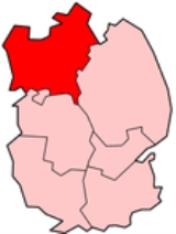
West Lindsey is a local government district
in Lincolnshire
, England
.
s of Gainsborough, Market Rasen, along with Caistor Rural District
, Gainsborough Rural District
and Welton Rural District
. The district council moved to new offices in Marshall's Yard in Gainsborough in January 2008.
The election for all 37 members representing 25 wards were held on 5 May 2011. All seats were contested. The total electorate entitled to vote at the elections was 71959 from which 31207 electors voted (43.37%). The result produced a Conservative majority of 5 seats over all other parties. The current membership of the Council is Conservatives 21, Independents 3, Labour 2 and Liberal Democrats 11.
and North East Lincolnshire
to the north, East Lindsey
to the east, North Kesteven
and the city of Lincoln to the south, and the county of Nottinghamshire
to the west.
It covers Gainsborough
, Market Rasen
, Sudbrooke
, Cherry Willingham
, Nettleham
, Welton
, Caistor
and Keelby
.
The boundary of the district in the west borders the River Trent
, and meets Nottinghamshire (Bassetlaw) and North Lincolnshire
at East Stockwith
, close to Wildsworth. On the other side of the Trent is Gunthorpe, North Lincolnshire. It deviates from the Trent, to the east along the River Eau at Scotter
, where it meets Messingham
in North Lincolnshire. The boundary deviates southwards near Scotton
, then at Northorpe
follows the B1205 eastwards, crossing the A15 at Waddingham
. It follows the Sallowrow Drain to the Old River Ancholme
at South Kelsey
, which it follows northwards. At North Kelsey
, it deviates from the Old River Ancholme, following the North Kelsey Beack eastwards. This crosses the B1434 then the Newark-Grimsby railway line, where at Searby cum Owmby it follows a drain parallel to the railway line northwards, and at Bigby
it follows Kettleby Beck westwards across the railway line back to the Old River Ancholme, which it follows for almost a mile towards Brigg
. The Bigby parish is the northern part of West Lindsey that skirts the southern edge of Brigg, crossing the A1084 and the railway line
.
Also in Bigby, it crosses the Scunthorpe-Grimsby line, then three railway lines together at Wrawby Junction
. North of Bigby village it crosses the western escarpment of the northern Lincolnshire Wolds
, then skirts the southern and eastern perimenter of Humberside Airport
. It crosses the A18 and B1210, then the B1211. The furthest north section of the district, and of the county, is where it meets a short section of the A180, where a few hundred metres west of the A160
interchange it meets North East Lincolnshire
. It follows the New Beck Drain south-east across the B1210, and at Riby
, the A1173 and A18. At Swallow
it crosses the A46
. It follows the Waithe Beck at Thorganby
. At Swinhope it meets East Lindsey
, next to Scallows Hall (in East Lindsey), and crosses the B1203, then again at Kirmond le Mire
. It meets the B1225 High Street at Tealby
, and for around two miles southwards is the district boundary, crossing the A631
at North Willingham
. At Sixhills
it deviates westwards from the B1225, next to the former RAF Ludford Magna
(in East Lindsey). At Holton cum Beckering
it crosses the B1202, then the A158
at Goltho
, where it skirts the western edge of Wragby
(in East Lindsey). It passes southwards in Bardney
through Chamber's Farm Wood (mostly in East Lindsey); Chamber's Farm itself is in West Lindsey. It skirts the southern edge of the former RAF Bardney
, and crosses the B1190 near Tupholme Abbey
(in East Lindsey). East of Southrey
(also in Bardney parish) it meets the River Witham
and North Kesteven
. It follows the River Witham westwards until Greetwell
where it meets the City of Lincoln, deviates northwards, crossing the Lincoln - Market Rasen railway line. It follows the outskirts of Lincoln, crossing the B1182 (former A46) at Nettleham. It crosses the A15 north of the Riseholme roundabout, and follows a short section of the A57
, then crosses it, near Bishop Bridge. A few hundred metres west it meets the Foss Dyke
, which from there a mile north-west is the boundary with North Kesteven
. At Saxilby with Ingleby it deviates westwards from the Foss Dyke, and at Broadholme
(former Nottinghamshire until 1989) at the B1190 (Tom Otters Lane), it meets Nottinghamshire (Newark and Sherwood
). It follows a half-mile section of Ox Pasture Drain north to the A57, which it briefly follows westwards until Kettlethorpe
(A156
junction). It crosses the A1133 at Newton on Trent
, and under a mile westwards it meets the River Trent
and Bassetlaw
, a mile north of the former High Marnham Power Station
.
, has a mixture of comprehensive schools in the south-east of the district and selective schools in Gainsborough (Queen Elizabeth's High School
, Trent Valley Academy) and Caistor. Both grammar schools are in the top ten for A level results in the East Midlands, with Caistor Grammar School
getting the best results in this region consistently year on year. It also gets some of the best results in England. These schools offer a standard of state education from ages 11–16 not available in the regions of Lincolnshire directly north of the district (former Lindsey
before 1974). Pupils from outside of the district may travel to be educated in Gainsborough from Scunthorpe
(12–15 miles via the A159
), and (in greater number) to Caistor from Grimsby
and Cleethorpes
(10–12 miles via the A46
). The situation is reversed in the sixth form with Lincolnshire pupils studying at the John Leggott College
in Scunthorpe and the Franklin College, Grimsby
. The best comprehensive in this district (and the county) is the William Farr School
in Welton, which gets A level results similar to a grammar school.
, to the north of the region. The A1500 (Tillbridge Lane) and A631
are the main east-west routes, and avoid busy town centres. The A631, further west, allows passage (through Bassetlaw
) to Robin Hood Airport Doncaster Sheffield
in the nearby Metropolitan Borough of Doncaster
. The north-south route is the A15, officially the straightest road in the UK, following the Roman road
Ermine Street
.
. The Lincolnshire Show is held in the district at the Lincolnshire Showground, south of RAF Scampton
, which is also the home for the Red Arrows
, officially known as the Royal Air Force Aerobatic Team.
Non-metropolitan district
Non-metropolitan districts, or colloquially shire districts, are a type of local government district in England. As created, they are sub-divisions of non-metropolitan counties in a so-called "two-tier" arrangement...
in Lincolnshire
Lincolnshire
Lincolnshire is a county in the east of England. It borders Norfolk to the south east, Cambridgeshire to the south, Rutland to the south west, Leicestershire and Nottinghamshire to the west, South Yorkshire to the north west, and the East Riding of Yorkshire to the north. It also borders...
, England
England
England is a country that is part of the United Kingdom. It shares land borders with Scotland to the north and Wales to the west; the Irish Sea is to the north west, the Celtic Sea to the south west, with the North Sea to the east and the English Channel to the south separating it from continental...
.
History
The district was formed on 1 April 1974, from the urban districtUrban district
In the England, Wales and Ireland, an urban district was a type of local government district that covered an urbanised area. Urban districts had an elected Urban District Council , which shared local government responsibilities with a county council....
s of Gainsborough, Market Rasen, along with Caistor Rural District
Caistor Rural District
Caistor was a rural district in Lincolnshire, Parts of Lindsey from 1894 to 1974.It was formed by the Local Government Act 1894 from Caistor rural sanitary district...
, Gainsborough Rural District
Gainsborough Rural District
Gainsborough was rural district in Lincolnshire, Parts of Lindsey from 1894 to 1974.It was formed under the Local Government Act 1894 from that part of the Gainsborough rural sanitary district which was in Lindsey...
and Welton Rural District
Welton Rural District
Welton was a rural district in Lincolnshire, Parts of Lindsey from 1894 to 1974. It was formed under the Local Government Act 1894 from that part of the Lincoln rural sanitary district which was in Lindsey - the Kesteven part forming the Branston Rural District...
. The district council moved to new offices in Marshall's Yard in Gainsborough in January 2008.
Governance
Since the inception of the council in 1974 councillors have been elected in ‘thirds’, serving a period of four years. This means that elections have been held every year apart from the fourth year when County Council elections are held. In December 2010 the Council decided to change the system from ‘thirds’ to ‘all out’ elections commencing in May 2011.The election for all 37 members representing 25 wards were held on 5 May 2011. All seats were contested. The total electorate entitled to vote at the elections was 71959 from which 31207 electors voted (43.37%). The result produced a Conservative majority of 5 seats over all other parties. The current membership of the Council is Conservatives 21, Independents 3, Labour 2 and Liberal Democrats 11.
Geography
West Lindsey borders North LincolnshireNorth Lincolnshire
North Lincolnshire is a unitary authority area in the region of Yorkshire and the Humber in England. For ceremonial purposes it is part of Lincolnshire....
and North East Lincolnshire
North East Lincolnshire
North East Lincolnshire is a unitary authority in the Yorkshire and the Humber region of England, bordering the unitary authority of North Lincolnshire and the administrative county of Lincolnshire...
to the north, East Lindsey
East Lindsey
East Lindsey is a local government district in Lincolnshire, England. The council is based in Manby near Louth, and other major settlements in the district include Alford, Spilsby, Mablethorpe, Skegness, Horncastle and Chapel St Leonards....
to the east, North Kesteven
North Kesteven
North Kesteven is a local government district in the East Midlands. Just over north of London, it is east of Nottingham and south of Lincoln. North Kesteven is one of seven districts in Lincolnshire, England and is in the centre of the County...
and the city of Lincoln to the south, and the county of Nottinghamshire
Nottinghamshire
Nottinghamshire is a county in the East Midlands of England, bordering South Yorkshire to the north-west, Lincolnshire to the east, Leicestershire to the south, and Derbyshire to the west...
to the west.
It covers Gainsborough
Gainsborough, Lincolnshire
Gainsborough is a town 15 miles north-west of Lincoln on the River Trent within the West Lindsey district of Lincolnshire, England. At one time it served as an important port with trade downstream to Hull, and was the most inland in England, being more than 55 miles from the North...
, Market Rasen
Market Rasen
Market Rasen is a town and civil parish within the West Lindsey district of Lincolnshire, England. It lies on the River Rase northeast of Lincoln, east of Gainsborough and southwest of Grimsby. According to the 2001 census, it has a population of 3,200....
, Sudbrooke
Sudbrooke
Sudbrooke is a small village in Lincolnshire, located approximately six miles north-east of Lincoln in England.Sudbrooke lies just off the A158 Lincoln - Skegness road, and although the original heart of the village near the church has existed for centuries, the main development as a commuter...
, Cherry Willingham
Cherry Willingham
Cherry Willingham is a village and civil parish in the West Lindsey district of Lincolnshire, England. It lies approximately four miles outside the city of Lincoln. Neighbouring villages are Reepham, Nettleham and Fiskerton....
, Nettleham
Nettleham
Nettleham is a large village and civil parish within the West Lindsey district of Lincolnshire, England.-Geography:It is located four miles north-east of the city of Lincoln between the A46 and A158, and has a total resident population of 6,514....
, Welton
Welton, Lincolnshire
Welton is a village and civil parish seven miles north of the city of Lincoln in the county of Lincolnshire, England, and the district of West Lindsey...
, Caistor
Caistor
See Caistor St Edmund for the Roman settlement in Norfolk or Caister-on-Sea for the town in NorfolkCaistor is a town and civil parish situated in the West Lindsey district of Lincolnshire, England. As its name implies, it was originally a Roman castrum or fortress...
and Keelby
Keelby
Keelby is a village in the county of Lincolnshire, England, near the seaports of Immingham and Grimsby. It is located near the local Humberside Airport and the main road running alongside the village is the A18....
.
The boundary of the district in the west borders the River Trent
River Trent
The River Trent is one of the major rivers of England. Its source is in Staffordshire on the southern edge of Biddulph Moor. It flows through the Midlands until it joins the River Ouse at Trent Falls to form the Humber Estuary, which empties into the North Sea below Hull and Immingham.The Trent...
, and meets Nottinghamshire (Bassetlaw) and North Lincolnshire
North Lincolnshire
North Lincolnshire is a unitary authority area in the region of Yorkshire and the Humber in England. For ceremonial purposes it is part of Lincolnshire....
at East Stockwith
East Stockwith
East Stockwith is a village within the civil parish of Stockwith, in the West Lindsey district of Lincolnshire, England. It has a total resident population of 209....
, close to Wildsworth. On the other side of the Trent is Gunthorpe, North Lincolnshire. It deviates from the Trent, to the east along the River Eau at Scotter
Scotter
Scotter is a large village and civil parish in West Lindsey, Lincolnshire, England, situated between Scunthorpe and Gainsborough.-Geography:The A159 road, which connects the two towns, crosses the River Eau in the village...
, where it meets Messingham
Messingham
Messingham is a small village outside Scunthorpe in North Lincolnshire, England. Messingham has a population of over about 4,000 people.-Geography:...
in North Lincolnshire. The boundary deviates southwards near Scotton
Scotton, Lincolnshire
Scotton is a village and civil parish in Lincolnshire, England. The village is in West Lindsey district, and south of the larger village of Scotter. The western boundary of the parish is formed by part of the A159 Gainsborough to Scunthorpe road...
, then at Northorpe
Northorpe, West Lindsey
Northorpe is a village and civil parish in the West Lindsey district of Lincolnshire, England, about north east of the town of Gainsborough. The site of this place is scheduled....
follows the B1205 eastwards, crossing the A15 at Waddingham
Waddingham
Waddingham is a village and civil parish in the West Lindsey district of Lincolnshire, England. According to the 2001 census it had a population of 548. It is just off the A15 north of Caenby Corner....
. It follows the Sallowrow Drain to the Old River Ancholme
River Ancholme
The River Ancholme is a river in North Lincolnshire, England, and a tributary of the Humber estuary.It rises south of Bishopbridge and passes through many Lincolnshire villages and the market town of Brigg before flowing north into the Humber at South Ferriby.North of Bishopbridge, where the River...
at South Kelsey
South Kelsey
South Kelsey is a village and civil parish in the West Lindsey district of Lincolnshire, England. It is on the B1205 between the A15 and Caistor.According to the 2001 census the village had a population of 571.South Kelsey has an Anglican church, St...
, which it follows northwards. At North Kelsey
North Kelsey
North Kelsey is a village and civil parish in the West Lindsey district of Lincolnshire, England. According to the 2001 census it had a population of 959. Also within the parish is the small hamlet of North Kelsey Moor, once the site of North Kelsey railway station. It is near Caistor...
, it deviates from the Old River Ancholme, following the North Kelsey Beack eastwards. This crosses the B1434 then the Newark-Grimsby railway line, where at Searby cum Owmby it follows a drain parallel to the railway line northwards, and at Bigby
Bigby, Lincolnshire
Bigby is a village and civil parish in the West Lindsey district of Lincolnshire, England. It lies about ten miles south of the Humber Bridge, and four miles east of the town of Brigg. The village lies in the Lincolnshire Wolds, a designated Area of Outstanding Natural Beauty and lies close to the...
it follows Kettleby Beck westwards across the railway line back to the Old River Ancholme, which it follows for almost a mile towards Brigg
Brigg
Brigg is a small market town in North Lincolnshire, England, with a population of 5,076 in 2,213 households . The town lies at the junction of the River Ancholme and east-west transport routes across northern Lincolnshire...
. The Bigby parish is the northern part of West Lindsey that skirts the southern edge of Brigg, crossing the A1084 and the railway line
Sheffield to Lincoln Line
The Sheffield to Lincoln line is a railway line in England. It runs from Sheffield east to Lincoln via Worksop, Retford and Gainsborough Lea Road. The route comprises the main line of the former Manchester, Sheffield and Lincolnshire Railway, to Gainsborough, Trent Junction, where it then follows...
.
Also in Bigby, it crosses the Scunthorpe-Grimsby line, then three railway lines together at Wrawby Junction
Wrawby Junction
Wrawby Junction is a busy railway junction located a short distance west of Barnetby, North Lincolnshire, England and controls the confluence of the Network Rail routes from Lincoln, Retford and Scunthorpe towards Immingham and Cleethorpes...
. North of Bigby village it crosses the western escarpment of the northern Lincolnshire Wolds
Lincolnshire Wolds
The Lincolnshire Wolds is a range of hills in the county of Lincolnshire, England. It is a designated Area of Outstanding Natural Beauty , and the highest area of land in eastern England between Yorkshire and Kent...
, then skirts the southern and eastern perimenter of Humberside Airport
Humberside Airport
-Cargo flights:Icelandair Cargo operate a weekly Sunday flight from Keflavík which then departs to Liege-Passenger statistics:-Bus service:An hourly daytime bus service runs from Grimsby and Hull to the airport from Monday to Saturday.-External links:**...
. It crosses the A18 and B1210, then the B1211. The furthest north section of the district, and of the county, is where it meets a short section of the A180, where a few hundred metres west of the A160
A160 road
The A160 is a road in North Lincolnshire, England. It connects the A180 to Immingham docks. It is a dual carriageway for part of its length through the village of South Killingholme. There are plans to entirely dual the road, though the scheme is subject to review following the 2010 general...
interchange it meets North East Lincolnshire
North East Lincolnshire
North East Lincolnshire is a unitary authority in the Yorkshire and the Humber region of England, bordering the unitary authority of North Lincolnshire and the administrative county of Lincolnshire...
. It follows the New Beck Drain south-east across the B1210, and at Riby
Riby
Riby is a village and civil parish in the West Lindsey district of Lincolnshire, England, about south west of the town of Grimsby.There are two scheduled barrows 650 metres south west of Riby Grove Farm. Whilst they are no longer visible above ground, the burial remains survive inside...
, the A1173 and A18. At Swallow
Swallow, Lincolnshire
Swallow is a small village and civil parish in the West Lindsey district of Lincolnshire, England, on the A46 road just northeast of Caistor. The village has a small war memorial.-History:...
it crosses the A46
A46 road
The A46 is an A road in England. It starts east of Bath, Somerset and ends in Cleethorpes, North East Lincolnshire, but it does not form a continuous route. Large portions of the old road have been lost, bypassed, or replaced by motorway development...
. It follows the Waithe Beck at Thorganby
Thorganby, Lincolnshire
Thorganby is a village and civil parish in the West Lindsey district of Lincolnshire. England. It is located about north east of the town of Market Rasen in the Lincolnshire Wolds a designated Area of Outstanding Natural Beauty....
. At Swinhope it meets East Lindsey
East Lindsey
East Lindsey is a local government district in Lincolnshire, England. The council is based in Manby near Louth, and other major settlements in the district include Alford, Spilsby, Mablethorpe, Skegness, Horncastle and Chapel St Leonards....
, next to Scallows Hall (in East Lindsey), and crosses the B1203, then again at Kirmond le Mire
Kirmond le Mire
Kirmond le Mire is a small village in West Lindsey in the English county of Lincolnshire. The location includes the lost settlement of Beckfield.- External links :*...
. It meets the B1225 High Street at Tealby
Tealby
Tealby is a village and civil parish in the West Lindsey district of Lincolnshire, England, situated on the edge of the Lincolnshire Wolds.Tealby is noted for the Tennyson d'Eyncourt family which donated the village hall and school. In the 1980s the school was used for filming the programme Nanny...
, and for around two miles southwards is the district boundary, crossing the A631
A631 road
The A631 is a road running from Sheffield, South Yorkshire to Louth, Lincolnshire in England. It passes through the counties of South Yorkshire, Nottinghamshire and Lincolnshire. The road has many towns on its route including Rotherham, Maltby, Gainsborough and Market Rasen. It is mostly single...
at North Willingham
North Willingham
North Willingham is a village and civil parish located about south east of the town of Market Rasen, Lincolnshire, England, on the A631 road between Market Rasen and Louth...
. At Sixhills
Sixhills
Sixhills is a village in the West Lindsey district of Lincolnshire, England, about south-east from Market Rasen. It lies just south of the A631 between Market Rasen and Ludford....
it deviates westwards from the B1225, next to the former RAF Ludford Magna
RAF Ludford Magna
RAF Ludford Magna was a Royal Air Force airfield operated by Bomber Command during World War II and the Cold War. The station lay on agricultural farmland immediately south of the village of Ludford, Lincolnshire and was sited 21.4 miles north east of the county town of Lincoln, Lincolnshire...
(in East Lindsey). At Holton cum Beckering
Holton cum Beckering
Holton cum Beckering is a small village and civil parish in West Lindsey, Lincolnshire, England. It lies south of Market Rasen at the junction of the B1202 and B1399 roads. At the 2001 Census it had a population of 140.-History:...
it crosses the B1202, then the A158
A158 road
The A158 road is a major tourist route that heads from Lincoln in the west to Skegness on the east coast. The road is located entirely in the county of Lincolnshire and is single carriageway for almost its entirety. The road is approximately long...
at Goltho
Goltho
Goltho is a village of Anglo-Saxon roots situated in Lincolnshire, England. It lies south of the A158 and west of Wragby.-History:There was a Romano-British settlement at Goltho in the 1st and 2nd centuries....
, where it skirts the western edge of Wragby
Wragby
Wragby is a small town and civil parish in the East Lindsey district of Lincolnshire, England. It is located approximately north-west from Horncastle and about north east of the city of Lincoln.- History :...
(in East Lindsey). It passes southwards in Bardney
Bardney
Bardney is a village and Civil Parish east of Lincoln, sitting on the north side of the River Witham in the West Lindsey district of Lincolnshire, England.-The village:...
through Chamber's Farm Wood (mostly in East Lindsey); Chamber's Farm itself is in West Lindsey. It skirts the southern edge of the former RAF Bardney
RAF Bardney
RAF Bardney was a RAF station situated near Bardney, in Lincolnshire, England. It was built as a satellite to RAF Waddington in 1943.-Time line:* Opened on 13 April 1943 as home to No. 9 Squadron...
, and crosses the B1190 near Tupholme Abbey
Tupholme Abbey
Tupholme Abbey was a Premonstratensian abbey close to the River Witham some 17 km east of the city of Lincoln, England. It was founded between 1155 and 1165 by Gilbert and Alan de Neville. An abbot and twelve canons were sent from Newsham Abbey, also in Lincolnshire, to found Tupholme...
(in East Lindsey). East of Southrey
Southrey
Southrey is a village in the civil parish of Bardney in the West Lindsey district of Lincolnshire, England, about south east of Bardney.In the 1086 Domesday Book Southrey was listed as "Sutrei" and consisted of eleven households....
(also in Bardney parish) it meets the River Witham
River Witham
The River Witham is a river, almost entirely in the county of Lincolnshire, in the east of England. It rises south of Grantham close to South Witham, at SK8818, passes Lincoln at SK9771 and at Boston, TF3244, flows into The Haven, a tidal arm of The Wash, near RSPB Frampton Marsh...
and North Kesteven
North Kesteven
North Kesteven is a local government district in the East Midlands. Just over north of London, it is east of Nottingham and south of Lincoln. North Kesteven is one of seven districts in Lincolnshire, England and is in the centre of the County...
. It follows the River Witham westwards until Greetwell
Greetwell
Greetwell is a village and civil parish about east of the city of Lincoln, Lincolnshire, England.The parish church is dedicated to All Saints and is a grade II* listed building built of limestone and dating from the 11th century, which was restored in the 19th century. Both the west tower and the...
where it meets the City of Lincoln, deviates northwards, crossing the Lincoln - Market Rasen railway line. It follows the outskirts of Lincoln, crossing the B1182 (former A46) at Nettleham. It crosses the A15 north of the Riseholme roundabout, and follows a short section of the A57
A57 road
The A57 is a major road in England. It runs east from Liverpool to Lincoln, via Warrington, Cadishead, Irlam, Patricroft, Eccles, Salford and Manchester, then through the Pennines over the Snake Pass , around the Ladybower Reservoir, through Sheffield and past Worksop...
, then crosses it, near Bishop Bridge. A few hundred metres west it meets the Foss Dyke
Foss Dyke
The Foss Dyke, or Fossdyke, connects the River Trent at Torksey to Lincoln, the county town of Lincolnshire, and may be the oldest canal in England that is still in use. It is usually thought to have been built around 120 AD by the Romans, but there is no consensus among authors...
, which from there a mile north-west is the boundary with North Kesteven
North Kesteven
North Kesteven is a local government district in the East Midlands. Just over north of London, it is east of Nottingham and south of Lincoln. North Kesteven is one of seven districts in Lincolnshire, England and is in the centre of the County...
. At Saxilby with Ingleby it deviates westwards from the Foss Dyke, and at Broadholme
Broadholme
Broadholme is a village and civil parish in the West Lindsey district of Lincolnshire, England. According to the 2001 census it had a population of 88.Prior to 1989 the parish was in the Newark and Sherwood district of Nottinghamshire.-External links:...
(former Nottinghamshire until 1989) at the B1190 (Tom Otters Lane), it meets Nottinghamshire (Newark and Sherwood
Newark and Sherwood
Newark and Sherwood is a local government district of eastern Nottinghamshire, England. The district is predominantly rural, with some large forestry plantations, and the towns of Newark-on-Trent, Southwell and Ollerton....
). It follows a half-mile section of Ox Pasture Drain north to the A57, which it briefly follows westwards until Kettlethorpe
Kettlethorpe, Lincolnshire
Kettlethorpe is a village and civil parish west of the city of Lincoln, Lincolnshire, England. The hamlets of Hardwick and Laughterton lie within this parish.-Church:...
(A156
A156 road
The A156 road runs from the A57 and heads north to Gainsborough. The road runs entirely within Lincolnshire right next to the border with Nottinghamshire. It is a single carriageway for its entire length. It is approximately long....
junction). It crosses the A1133 at Newton on Trent
Newton on Trent
Newton on Trent is a village and civil parish in the West Lindsey district of Lincolnshire, England. It lies about south of Gainsborough and west of Lincoln east of the River Trent at the junction of the A57 running east to west, and the A1133 running north to south.West of the village, between...
, and under a mile westwards it meets the River Trent
River Trent
The River Trent is one of the major rivers of England. Its source is in Staffordshire on the southern edge of Biddulph Moor. It flows through the Midlands until it joins the River Ouse at Trent Falls to form the Humber Estuary, which empties into the North Sea below Hull and Immingham.The Trent...
and Bassetlaw
Bassetlaw
Bassetlaw is the northernmost district of Nottinghamshire, England, with a population according to the 2001 UK census of 107,713. The borough is predominantly rural, with two towns: Worksop, site of the borough offices, and Retford...
, a mile north of the former High Marnham Power Station
High Marnham Power Station
High Marnham Power Station is a former coal-fired power station, currently undergoing demolition. It is located in Nottinghamshire, to the west of the River Trent, just south of the village of Dunham. It was the most southerly of three power stations which lined the River Trent, the others being...
.
Education
The district, similar to North and South KestevenSouth Kesteven
South Kesteven is a local government district in Lincolnshire, England, forming part of the traditional Kesteven division of the county. It covers Grantham, Stamford, Bourne and Market Deeping.-History:...
, has a mixture of comprehensive schools in the south-east of the district and selective schools in Gainsborough (Queen Elizabeth's High School
Queen Elizabeth's High School
Queen Elizabeth's High School is an 11-18 co-educational selective state grammar school, based in Gainsborough in western Lincolnshire, England.The school is selective; pupils wishing to enter at age 11 must sit and pass the Eleven Plus exam prior to entry...
, Trent Valley Academy) and Caistor. Both grammar schools are in the top ten for A level results in the East Midlands, with Caistor Grammar School
Caistor Grammar School
Caistor Grammar School is a selective school and academy in the English town of Caistor in the county of Lincolnshire. It was founded in 1630, and has since grown to be one of the most respected and high performing schools in the East of England. The school has been awarded specialist sports and...
getting the best results in this region consistently year on year. It also gets some of the best results in England. These schools offer a standard of state education from ages 11–16 not available in the regions of Lincolnshire directly north of the district (former Lindsey
Lindsey
Lindsey was a unit of local government until 1974 in Lincolnshire, England, covering the northern part of the county. The Isle of Axholme, which is on the west side of the River Trent, has normally formed part of it...
before 1974). Pupils from outside of the district may travel to be educated in Gainsborough from Scunthorpe
Scunthorpe
Scunthorpe is a town within North Lincolnshire, England. It is the administrative centre of the North Lincolnshire unitary authority, and had an estimated total resident population of 72,514 in 2010. A predominantly industrial town, Scunthorpe, the United Kingdom's largest steel processing centre,...
(12–15 miles via the A159
A159 road
The A159 is a 16 mile-long single carriage A-road, running between Scunthorpe and Gainsborough in Lincolnshire.- Route :...
), and (in greater number) to Caistor from Grimsby
Grimsby
Grimsby is a seaport on the Humber Estuary in Lincolnshire, England. It has been the administrative centre of the unitary authority area of North East Lincolnshire since 1996...
and Cleethorpes
Cleethorpes
Cleethorpes is a town and unparished area in North East Lincolnshire, England, situated on the estuary of the Humber. It has a population of 31,853 and is a seaside resort.- History :...
(10–12 miles via the A46
A46 road
The A46 is an A road in England. It starts east of Bath, Somerset and ends in Cleethorpes, North East Lincolnshire, but it does not form a continuous route. Large portions of the old road have been lost, bypassed, or replaced by motorway development...
). The situation is reversed in the sixth form with Lincolnshire pupils studying at the John Leggott College
John Leggott College
John Leggott College is a sixth form college on West Common Lane, in Old Brumby, Scunthorpe, North Lincolnshire, England.-Technical school:...
in Scunthorpe and the Franklin College, Grimsby
Franklin College, Grimsby
Franklin College is a sixth form college on Chelmsford Avenue in Grimsby in North East Lincolnshire.-Admissions:It is specifically for students aged 16–19 who want to study for A-levels from the whole of North East Lincolnshire, however mature students are also welcome to enrol and evening classes...
. The best comprehensive in this district (and the county) is the William Farr School
William Farr School
William Farr Church of England Comprehensive School, generallyknown as William Farr School or just William Farr , is a Church of England comprehensive school in Dunholme, though the postal address places the school in Welton, five miles north-east of Lincoln...
in Welton, which gets A level results similar to a grammar school.
Transport
Large parts of the district can be accessed from the M180M180 motorway
The M180 motorway is a short but major motorway in England from junction 5 on the M18 motorway in the Metropolitan Borough of Doncaster to a point close to Humberside Airport some from the ports of Immingham and Grimsby and the east coast and provides access for major routes to Cleethorpes,...
, to the north of the region. The A1500 (Tillbridge Lane) and A631
A631 road
The A631 is a road running from Sheffield, South Yorkshire to Louth, Lincolnshire in England. It passes through the counties of South Yorkshire, Nottinghamshire and Lincolnshire. The road has many towns on its route including Rotherham, Maltby, Gainsborough and Market Rasen. It is mostly single...
are the main east-west routes, and avoid busy town centres. The A631, further west, allows passage (through Bassetlaw
Bassetlaw
Bassetlaw is the northernmost district of Nottinghamshire, England, with a population according to the 2001 UK census of 107,713. The borough is predominantly rural, with two towns: Worksop, site of the borough offices, and Retford...
) to Robin Hood Airport Doncaster Sheffield
Robin Hood Airport Doncaster Sheffield
Robin Hood Airport Doncaster Sheffield is an international airport located at the former RAF Finningley airbase at Finningley, in the Metropolitan Borough of Doncaster within South Yorkshire, England. The airport lies southeast of Doncaster and east of Sheffield.The airport is operated by Peel...
in the nearby Metropolitan Borough of Doncaster
Metropolitan Borough of Doncaster
The Metropolitan Borough of Doncaster is a metropolitan borough of South Yorkshire in Yorkshire and the Humber Region of England.In addition to the town of Doncaster, the borough covers Mexborough, Conisbrough, Thorne and Finningley....
. The north-south route is the A15, officially the straightest road in the UK, following the Roman road
Roman road
The Roman roads were a vital part of the development of the Roman state, from about 500 BC through the expansion during the Roman Republic and the Roman Empire. Roman roads enabled the Romans to move armies and trade goods and to communicate. The Roman road system spanned more than 400,000 km...
Ermine Street
Ermine Street
Ermine Street is the name of a major Roman road in England that ran from London to Lincoln and York . The Old English name was 'Earninga Straete' , named after a tribe called the Earningas, who inhabited a district later known as Armingford Hundred, around Arrington, Cambridgeshire and Royston,...
.
Tourism
Attractions to the district include the Lincolnshire WoldsLincolnshire Wolds
The Lincolnshire Wolds is a range of hills in the county of Lincolnshire, England. It is a designated Area of Outstanding Natural Beauty , and the highest area of land in eastern England between Yorkshire and Kent...
. The Lincolnshire Show is held in the district at the Lincolnshire Showground, south of RAF Scampton
RAF Scampton
Royal Air Force Station Scampton is a Royal Air Force station situated north of Lincoln in England, near the village of Scampton, on the site of an old First World War landing field.-First World War:...
, which is also the home for the Red Arrows
Red Arrows
The Red Arrows, officially known as the Royal Air Force Aerobatic Team, is the aerobatics display team of the Royal Air Force based at RAF Scampton, but due to move to RAF Waddington in 2011...
, officially known as the Royal Air Force Aerobatic Team.