
East Northamptonshire
Encyclopedia
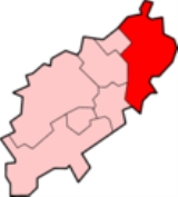
East Northamptonshire is a local government district
in Northamptonshire
, England
. Its council is based in Thrapston
and Rushden
, which is the largest town in the area. Other towns include Oundle
, Raunds
, Irthlingborough
and Higham Ferrers
.
The district borders onto the Borough of Corby, the Borough of Kettering, the Borough of Wellingborough, the Borough of Bedford, the Soke of Peterborough, the county of Cambrideshire and the county of Rutland.
The district was formed on 1 April 1974, under the Local Government Act 1972
, by a merger of the municipal borough
of Higham Ferrers
, with the urban district
s of Irthlingborough
, Oundle, Raunds
and Rushden, along with Oundle and Thrapston Rural District
, and Newton Bromswold
from Wellingborough Rural District.
The district is home to the beautiful wooded areas of Fineshade Wood
, Wakerley Great Wood and Fermyn Wood in the remaining existing parts of Rockingham Forest
, at one time a royal hunting forest.
The district is also home to several of Northamptonshire's airfields including Spanhoe airfield, King's Cliffe airfield, Deenethorpe airfield, Polebrook airfield, Chelveston airfield and Lyveden airfield.
The vast majority of East Northamptonshire is included in the Corby parliamentary constituency and is currently served by Louise Mensch MP. The only settlements in East Northants which are excluded from the Corby parliamentary constituency are Higham Ferrers and Rushden, which instead are included in the "Wellingborough and Rushden" parliamentary constituency currently served by Peter Bone MP.
Election results 2007 (total 40 seats)
Conservative - 39 seats (+ 6)
Labour - 0 seats ( - 3)
Independent - 1 seat
Election results 2003 (total 36 seats)
Conservative - 33 seats (+ 12)
Labour - 3 seats (- 12)
and chichele college. Irthlingborough
is home to Rushden & Diamonds Football Club.
There are no railway stations in East Northamptonshire. There is one College
in East Northamptonshire.
Non-metropolitan district
Non-metropolitan districts, or colloquially shire districts, are a type of local government district in England. As created, they are sub-divisions of non-metropolitan counties in a so-called "two-tier" arrangement...
in Northamptonshire
Northamptonshire
Northamptonshire is a landlocked county in the English East Midlands, with a population of 629,676 as at the 2001 census. It has boundaries with the ceremonial counties of Warwickshire to the west, Leicestershire and Rutland to the north, Cambridgeshire to the east, Bedfordshire to the south-east,...
, England
England
England is a country that is part of the United Kingdom. It shares land borders with Scotland to the north and Wales to the west; the Irish Sea is to the north west, the Celtic Sea to the south west, with the North Sea to the east and the English Channel to the south separating it from continental...
. Its council is based in Thrapston
Thrapston
Thrapston is a small town in Northamptonshire, England. It is the headquarters of the East Northamptonshire district, and in 2001 had a population of 4,855. By 2006, this was estimated to be over 5,700....
and Rushden
Rushden
Rushden is a town and civil parish in the county of Northamptonshire, England.The parish of Rushden covers an area of some and is part of the district of East Northamptonshire. The population of Rushden was estimated at around 28,368, making it the fifth largest town in the county...
, which is the largest town in the area. Other towns include Oundle
Oundle
Oundle is an ancient market town on the River Nene in Northamptonshire, England, with a population of 5,345 or 5,674 . It lies some north of London and south-west of Peterborough...
, Raunds
Raunds
Raunds is a small market town in rural Northamptonshire, England. It has a population of 8,275 , is a civil parish, and is part of the East Northamptonshire district.- Geography :Raunds is situated 21 miles north-east of Northampton...
, Irthlingborough
Irthlingborough
Irthlingborough , originally called Artleborough, is a small town on the River Nene in Northamptonshire, England with a population of 6,179 people according to the 2001 census. It is the smallest town in England to have possessed a league association football team, Rushden & Diamonds. The parish...
and Higham Ferrers
Higham Ferrers
Higham Ferrers is a market town in the Nene Valley in East Northamptonshire, England, close to the Cambridgeshire and Bedfordshire borders. It forms a single urban area with Rushden to the south and has an estimated population of 6,086...
.
The district borders onto the Borough of Corby, the Borough of Kettering, the Borough of Wellingborough, the Borough of Bedford, the Soke of Peterborough, the county of Cambrideshire and the county of Rutland.
The district was formed on 1 April 1974, under the Local Government Act 1972
Local Government Act 1972
The Local Government Act 1972 is an Act of Parliament in the United Kingdom that reformed local government in England and Wales on 1 April 1974....
, by a merger of the municipal borough
Municipal borough
Municipal boroughs were a type of local government district which existed in England and Wales between 1835 and 1974, in Northern Ireland from 1840 to 1973 and in the Republic of Ireland from 1840 to 2002...
of Higham Ferrers
Higham Ferrers
Higham Ferrers is a market town in the Nene Valley in East Northamptonshire, England, close to the Cambridgeshire and Bedfordshire borders. It forms a single urban area with Rushden to the south and has an estimated population of 6,086...
, with the urban district
Urban district
In the England, Wales and Ireland, an urban district was a type of local government district that covered an urbanised area. Urban districts had an elected Urban District Council , which shared local government responsibilities with a county council....
s of Irthlingborough
Irthlingborough
Irthlingborough , originally called Artleborough, is a small town on the River Nene in Northamptonshire, England with a population of 6,179 people according to the 2001 census. It is the smallest town in England to have possessed a league association football team, Rushden & Diamonds. The parish...
, Oundle, Raunds
Raunds
Raunds is a small market town in rural Northamptonshire, England. It has a population of 8,275 , is a civil parish, and is part of the East Northamptonshire district.- Geography :Raunds is situated 21 miles north-east of Northampton...
and Rushden, along with Oundle and Thrapston Rural District
Oundle and Thrapston Rural District
Oundle and Thrapston was a rural district in Northamptonshire, England from 1935 to 1974.It was formed in 1935 under the County Review Order as a merger of the Easton on the Hill Rural District, the Gretton Rural District, and the parts of the Oundle Rural District and the Thrapston Rural District...
, and Newton Bromswold
Newton Bromswold
Newton Bromswold is a village and civil parish about east of Rushden, just inside Northamptonshire's border with Bedfordshire. At the time of the 2001 census, the parish's population was 62 people in 27 households. It is near the villages of Wymington, Chelveston, Knotting, Knotting Green,...
from Wellingborough Rural District.
The district is home to the beautiful wooded areas of Fineshade Wood
Fineshade Wood
Fineshade Wood is a large wooded area in the county of Northamptonshire in the English East Midlands region. The wood is protected by and cared for by the Forestry Commission and is part of the former royal hunting forest of Rockingham Forest....
, Wakerley Great Wood and Fermyn Wood in the remaining existing parts of Rockingham Forest
Rockingham Forest
Rockingham Forest is a former Mediæval royal hunting forest in the East Midlands region of England; most of which was in the county of Northamptonshire but also extended slightly into the neighbouring counties of Leicestershire and Lincolnshire .The forest originally stretched from Stamford down...
, at one time a royal hunting forest.
The district is also home to several of Northamptonshire's airfields including Spanhoe airfield, King's Cliffe airfield, Deenethorpe airfield, Polebrook airfield, Chelveston airfield and Lyveden airfield.
The vast majority of East Northamptonshire is included in the Corby parliamentary constituency and is currently served by Louise Mensch MP. The only settlements in East Northants which are excluded from the Corby parliamentary constituency are Higham Ferrers and Rushden, which instead are included in the "Wellingborough and Rushden" parliamentary constituency currently served by Peter Bone MP.
Election results 2007 (total 40 seats)
Conservative - 39 seats (+ 6)
Labour - 0 seats ( - 3)
Independent - 1 seat
Election results 2003 (total 36 seats)
Conservative - 33 seats (+ 12)
Labour - 3 seats (- 12)
Geography
There are six towns in the district. Rushden is by far the largest with a population of 25,849. It is situated in the very south of the district. The second largest town is Raunds with a population of around 8,000. The smallest town in the district is Thrapston where the HQ of the East Northamptonshire council is located. Oundle is a historical market town with many ancient buildings and a large Public School. Higham Ferrers, which is part of Rushden's urban area, was the birthplace for Henry ChicheleHenry Chichele
Henry Chichele , English archbishop, founder of All Souls College, Oxford, was born at Higham Ferrers, Northamptonshire, in 1363 or 1364...
and chichele college. Irthlingborough
Irthlingborough
Irthlingborough , originally called Artleborough, is a small town on the River Nene in Northamptonshire, England with a population of 6,179 people according to the 2001 census. It is the smallest town in England to have possessed a league association football team, Rushden & Diamonds. The parish...
is home to Rushden & Diamonds Football Club.
There are no railway stations in East Northamptonshire. There is one College
The East Northamptonshire College
The East Northamptonshire College or TENC for short is a consortium of secondary schools in East Northamptonshire that offer Post-16 education.-Structure:...
in East Northamptonshire.
Settlements and parishes
- AchurchAchurchAchurch is a village in Northamptonshire, England. It was called Asechirce in the Domesday Book....
, AldwincleAldwincleAldwincle is a village in the east of the county of Northamptonshire, England. It is on a bend of the River Nene not far from Thrapston.In 1879, two ecclesiastical parishes, Aldwinkle All Saints and Aldwinkle St Peter merged after the parish church of the former was declared redundant in 1971 and...
, ApethorpeApethorpeApethorpe is a village and civil parish in East Northamptonshire district of the shire county of Northamptonshire, England. The 2001 census records a population of 133....
, AshtonAshton, East NorthamptonshireAshton is a village and civil parish about ¾ mile east of Oundle in the east of the English county of Northamptonshire forming part of the district of East Northamptonshire.-History:... - BarnwellBarnwell, NorthamptonshireBarnwell is a village in the district of East Northamptonshire in England, south of the town of Oundle, north of London and south-west of Peterborough...
, BenefieldBenefieldBenefield is a civil parish in East Northamptonshire, England, along the A427 road and about east of Corby and west of Oundle.-History:The name has evolved from Benefield ; Banefield, Benifeld ; Beningfelde, Benefilde, Berifelde, Benetfeld, Benifeud, Beningfeud ; Benyngfielde alias Benefielde...
, BlatherwyckeBlatherwyckeBlatherwycke is a village and civil parish in the East Northamptonshire district of Northamptonshire, England. It is about north-east of Corby. It is near Blatherwycke Lake, on the Willow Brook.-Demographics:...
, BrigstockBrigstockBrigstock is a village and civil parish in the English county of Northamptonshire. Administratively it is part of the district of East Northamptonshire...
, BulwickBulwickBulwick is a village and civil parish in the East Northamptonshire district of Northamptonshire, England. According to the 2001 census it had a population of 152 people. It is about six miles north-east of Corby, and is just off the A43 road. The Willow Brook runs through the village.... - Chelveston cum CaldecottChelvestonChelveston is a small village in Northamptonshire, England and is part of the East Northamptonshire district. To the south is the hamlet of Caldecott and the settlement of Chelston Rise which together comprise the civil parish called Chelveston-cum-Caldecott....
, CloptonClopton, NorthamptonshireClopton is a small village and civil parish located in East Northamptonshire, close to the Cambridgeshire border. The village stretches along the north side of the B662 and was recorded in the Domesday Book as 'Clotone'. At the time of the 2001 census, the parish's population was 134 people. The...
, CollywestonCollywestonCollyweston is a village and civil parish about three miles south-west of Stamford on the road to Kettering.-Geography:The village is on the southern side of the Welland valley of Tixover. The River Welland, at the point nearby to the north-west, is the boundary between Rutland and...
, CotterstockCotterstockCotterstock is a village and civil parish in East Northamptonshire, England.-Geography:Cotterstock is on the banks of the River Nene, which flows through the town of Peterborough 16 miles to the north east and empties into the North Sea in The Wash... - DeeneDeeneDeene is a small village and civil parish near Deenethorpe and Bulwick in East Northamptonshire. It has a village hall....
, DeenethorpeDeenethorpeDeenethorpe is a village and civil parish in the East Northamptonshire district of Northamptonshire, England. It is situated north-east of Corby and near the A43 road between Corby and Stamford. Nearby villages are Deene, Bulwick and Upper Benefield...
, DenfordDenfordDenford is a small village and civil parish situated in East Northamptonshire, England. At the time of the 2001 census, the parish population was 250 people....
, Duddington-with-Fineshade - Easton-on-the-Hill
- FotheringhayFotheringhayFotheringhay is a village and civil parish in Northamptonshire, England, six kilometres north east of Oundle and around west of Peterborough. It is most noted for being the site of Fotheringhay Castle which was razed in 1627...
- GlapthornGlapthornGlapthorn is a village and civil parish in East Northamptonshire, England. At the time of the 2001 census, the parish's population was 264 people....
, Great AddingtonGreat AddingtonGreat Addington is a small village and civil parish in Northamptonshire, England. It lies near the west bank of the River Nene, about 5 miles east of Kettering. It consists of approximately 100 houses; at the time of the 2001 census, the population of the parish was 319 people... - HargraveHargrave, NorthamptonshireHargrave is a small village and civil parish situated in rural Northamptonshire, England, approximately 21 miles east of Northampton and adjacent to the Northamptonshire-Cambridgeshire-Bedfordshire border...
, HarringworthHarringworthHarringworth is a village and civil parish in East Northamptonshire extremely close to the Northants-Rutland border. At the time of the 2001 census, the parish's population was 247 people....
, HemingtonHemington, NorthamptonshireHemington is a village and civil parish in East Northamptonshire, England....
, Higham FerrersHigham FerrersHigham Ferrers is a market town in the Nene Valley in East Northamptonshire, England, close to the Cambridgeshire and Bedfordshire borders. It forms a single urban area with Rushden to the south and has an estimated population of 6,086... - IrthlingboroughIrthlingboroughIrthlingborough , originally called Artleborough, is a small town on the River Nene in Northamptonshire, England with a population of 6,179 people according to the 2001 census. It is the smallest town in England to have possessed a league association football team, Rushden & Diamonds. The parish...
, IslipIslip, NorthamptonshireIslip is a village and civil parish in East Northamptonshire, England. It is close to the town of Thrapston, 5 miles from Little Addington and 7 miles east of Kettering. At the time of the 2001 census, the parish's population was 763 people. Islip is linked to Corby which is 10 miles north-west... - King`s CliffeKings Cliffe, NorthamptonshireKings Cliffe is a village and civil parish in East Northamptonshire, England, between Corby and Peterborough.It once had its own railway station, which is now closed.-Population:...
- LaxtonLaxton, NorthamptonshireLaxton is a village in East Northamptonshire, seven miles east of Corby and approximately one mile west of the A43. At the time of the 2001 census, the parish's population was 160 people.-History:...
, Lilford-cum-Wigsthorpe - Little AddingtonLittle AddingtonLittle Addington is a village and civil parish in East Northamptonshire. At the time of the 2001 census, the parish's population was 275 people....
, LowickLowick, NorthamptonshireLowick is a village and civil parish in Northamptonshire, England. It appears in the Domesday Book as Luhwik, and later as Lofwyk and in 1167 as Luffewich. The name derives from Old English "Luhha's or Luffa's dwelling place", wic being cognate to vicus in Latin...
, Luddington, LuttonLutton, NorthamptonshireLutton is a village and civil parish in East Northamptonshire, England. At the time of the 2001 census, the parish's population was 145 people.... - NassingtonNassingtonNassington is a village and civil parish in East Northamptonshire, England. At the time of the 2001 census, the parish's population was 670 people. The River Nene runs along the eastern side of the parish....
, Newton BromswoldNewton BromswoldNewton Bromswold is a village and civil parish about east of Rushden, just inside Northamptonshire's border with Bedfordshire. At the time of the 2001 census, the parish's population was 62 people in 27 households. It is near the villages of Wymington, Chelveston, Knotting, Knotting Green,... - OundleOundleOundle is an ancient market town on the River Nene in Northamptonshire, England, with a population of 5,345 or 5,674 . It lies some north of London and south-west of Peterborough...
- PiltonPilton, NorthamptonshirePilton is a hamlet and civil parish in East Northamptonshire, England....
, PolebrookPolebrook-History:There is evidence that Polebrook as a settlement dates back to 4000 BC,. The farms were mainly centred around the modern day village of Ashton... - RaundsRaundsRaunds is a small market town in rural Northamptonshire, England. It has a population of 8,275 , is a civil parish, and is part of the East Northamptonshire district.- Geography :Raunds is situated 21 miles north-east of Northampton...
, RingsteadRingstead, NorthamptonshireRingstead is a small village and civil parish in Northamptonshire, England approximately 15 miles north-east of Northampton. At the time of the 2001 census, the parish's population was 1,428 people....
, RushdenRushdenRushden is a town and civil parish in the county of Northamptonshire, England.The parish of Rushden covers an area of some and is part of the district of East Northamptonshire. The population of Rushden was estimated at around 28,368, making it the fifth largest town in the county... - ShotleyShotleyShotley may refer to several place:*Shotley, Suffolk, a village in England*Shotley Bridge, a village in County Durham, England* Shotley peninsula, a peninsula in Suffolk, England named for Shotley village...
, SouthwickSouthwick, NorthamptonshireSouthwick is a small village and civil parish in Northamptonshire, England. It is approximately north of the town of Oundle and is set in a valley of the river Nene. The village falls within the Non-Metropolitan District of East Northamptonshire, which itself lies within the East Midlands region...
, StanwickStanwick, NorthamptonshireStanwick is a village and civil parish in East Northamptonshire, England. It is approximately 15 miles north-east of Northampton and is the largest village in the East Northamptonshire district. At the time of the 2001 census, the parish population was 1,924 people.-History:There has been a...
, Stoke DoyleStoke DoyleStoke Doyle is a village and civil parish in East Northamptonshire in England, two miles south-west of Oundle.-Governance:It is represented on the parish council of Pilton, Stoke Doyle and Wadenhoe, on East Northamptonshire District Council and Northamptonshire County Council...
, SudboroughSudboroughSudborough is a village and civil parish in East Northamptonshire. At the time of the 2001 census, the parish's population was 189 people.Sudborough is bypassed by the A6116 road and is in the boundaries of the ancient Rockingham Forest; its nearest town is Thrapston, to its south-east.- External... - TansorTansorTansor is a village and civil parish in the English county of Northamptonshire. Lying near the River Nene, three miles north-east of the town of Oundle, Tansor forms part of the district of East Northamptonshire. At the time of the 2001 census, the parish's population was 185 people...
, ThrapstonThrapstonThrapston is a small town in Northamptonshire, England. It is the headquarters of the East Northamptonshire district, and in 2001 had a population of 4,855. By 2006, this was estimated to be over 5,700....
, ThurningThurning, NorthamptonshireThurning is a village and civil parish in the English county of Northamptonshire. Located in the north-east of the county, about 5.5 miles south-east of Oundle, Thurning forms part of the district of East Northamptonshire and the civil parish of Hemington, Luddington and Thurning...
, Thorpe WatervilleThorpe WatervilleThorpe Waterville is a village in the English county of Northamptonshire. It is combined with Achurch to form the ecclesiastical parish of 'Thorpe Achurch'; in turn this is added to another combined parish, Lilford-cum-Wigsthorpe, to form the civil parish of Lilford-cum-Wigsthorpe and Thorpe Achurch...
, TitchmarshTitchmarsh, NorthamptonshireTitchmarsh is a village and civil parish in East Northamptonshire, England. At the time of the 2001 census, the parish's population was 543 people....
, TwywellTwywellTwywell is a village and civil parish in the English county of Northamptonshire.Located just to the north of the A14 road approximately three miles west of Thrapston, Twywell forms part of the district of East Northamptonshire.-History:... - WadenhoeWadenhoeWadenhoe is a village and civil parish in East Northamptonshire. Part of the civil parish of Pilton, Stoke Doyle and Wadenhoe, it is on the River Nene, approximately 4 miles from Thrapston and 10 miles from Kettering. The Nene Way long distance footpath passes through the village...
, WakerleyWakerleyWakerley is a linear village and civil parish in the English county of Northamptonshire.Forming part of the district of East Northamptonshire, Wakerley is close to, and south of, the River Welland that forms the boundary with Rutland; its nearest neighbour, Barrowden, is in that county and...
, WarmingtonWarmington, NorthamptonshireWarmington is a village and civil parish in East Northamptonshire, England with a population of 874.The Nene Way footpath runs through it and is well signposted. It is 2½ miles east of the town of Oundle near the Cambridgeshire border and is 10 miles south west of the city of Peterborough. It has...
, WoodfordWoodford, NorthamptonshireWoodford is a large village and civil parish in East Northamptonshire, England. At the time of the 2001 census, the parish's population was 1,290 people....
, WoodnewtonWoodnewtonWoodnewton is a village in Northamptonshire, England. Essentially a pair of parallel streets, the village lies to the north of a small stream, the Willow Brook, in Rockingham Forest. It is in the East Northamptonshire district. At the time of the 2001 census, the parish's population was 442... - YarwellYarwellYarwell is a village on the River Nene in the extreme east of the English county of Northamptonshire near the border with Cambridgeshire. Its name is derived from 'the spring where the yarrow grows'. At the time of the 2001 census, the parish's population was 316 people.Yarwell has a pub called The...