

Smith Cove (Washington)
Encyclopedia
Body of water
A body of water or waterbody is any significant accumulation of water, usually covering the Earth or another planet. The term body of water most often refers to large accumulations of water, such as oceans, seas, and lakes, but it may also include smaller pools of water such as ponds, puddles or...
, the northern part of Seattle
Seattle, Washington
Seattle is the county seat of King County, Washington. With 608,660 residents as of the 2010 Census, Seattle is the largest city in the Northwestern United States. The Seattle metropolitan area of about 3.4 million inhabitants is the 15th largest metropolitan area in the country...
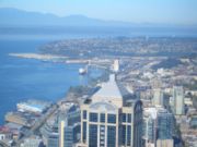
, Washington's Elliott Bay
Elliott Bay
Elliott Bay is the body of water on which Seattle, Washington, is located. A line drawn from Alki Point in the south to West Point in the north serves to mark the generally accepted division between the bay and the open sound...
, immediately south of the area that has been known since 1894 as Interbay
Interbay, Seattle, Washington
Interbay is a neighborhood in Seattle, Washington in the United States consisting of the valley between Queen Anne Hill on the east and Magnolia on the west, plus filled-in areas of Smith Cove and Salmon Bay...
. More precisely, it is the part of the bay that lies north of a line running southeasterly from the west end of Elliott Bay Marina in the northwest to the far northwest tip of Myrtle Edwards Park
Myrtle Edwards Park
Myrtle Edwards Park in Seattle, Washington is a 4.8 acre public park along the Elliott Bay waterfront north of Belltown. It features a 1.25-mile long bicycle and walking path and is a good place to see eagles, gulls, and crows....
in the southeast.
It is home to the Port of Seattle
Port of Seattle
The Port of Seattle is a port district that runs Seattle's seaport and airport. Its creation was approved by the voters of King County, Washington, on September 5, 1911, authorized by the Port District Act. It is run by a five-member commission. The commissioners' terms run four years...
's Piers 90 and 91, in addition to the marina.
The cove was named after Dr. Henry A. Smith
Henry A. Smith
Dr. Henry A. Smith was a physician, poet, legislator and early settler of Seattle, best known today for his flowery translation of a speech by Chief Seattle that is still in print....
of Wooster, Ohio
Wooster, Ohio
Wooster is a city in the U.S. state of Ohio and the county seat of Wayne County. The municipality is located in northeastern Ohio approximately SSW of Cleveland and SW of Akron. Wooster is noted as the location of The College of Wooster...
, who, in 1853, was one of the first whites to settle in what is now Seattle. It was briefly a candidate to be the heart of the emerging city. The cove
Cove
A cove is a small type of bay or coastal inlet. They usually have narrow, restricted entrances, are often circular or oval, and are often inside a larger bay. Small, narrow, sheltered bays, inlets, creeks, or recesses in a coast are often considered coves...
and its tide flats once stretched as far north as what is now the Interbay Athletic Field. James J. Hill
James J. Hill
James Jerome Hill , was a Canadian-American railroad executive. He was the chief executive officer of a family of lines headed by the Great Northern Railway, which served a substantial area of the Upper Midwest, the northern Great Plains, and Pacific Northwest...
bought 600 acres (2.4 km²) of these tide flats in 1892 and had them filled in for the western terminal of the Great Northern Railway. At one time, the terminal included a switchyard, roundhouse
Roundhouse
A roundhouse is a building used by railroads for servicing locomotives. Roundhouses are large, circular or semicircular structures that were traditionally located surrounding or adjacent to turntables...
, grain elevator
Grain elevator
A grain elevator is a tower containing a bucket elevator, which scoops up, elevates, and then uses gravity to deposit grain in a silo or other storage facility...
s, and warehouses as well as piers for oceangoing ships. Today, the rail yards of the BNSF Railway
BNSF Railway
The BNSF Railway is a wholly owned subsidiary of Berkshire Hathaway Inc., and is headquartered in Fort Worth, Texas. It is one of seven North American Class I railroads and the second largest freight railroad network in North America, second only to the Union Pacific Railroad, its primary...
remain, as does the aforementioned athletic field. Other present-day features on landfill
Landfill
A landfill site , is a site for the disposal of waste materials by burial and is the oldest form of waste treatment...
in what was formerly the cove are the Interbay Golf
Golf
Golf is a precision club and ball sport, in which competing players use many types of clubs to hit balls into a series of holes on a golf course using the fewest number of strokes....
Center and the Washington Army National Guard
Army National Guard
Established under Title 10 and Title 32 of the U.S. Code, the Army National Guard is part of the National Guard and is divided up into subordinate units stationed in each of the 50 states, three territories and the District of Columbia operating under their respective governors...
Armory.
Before 1900
Although Smith Cove fell within the traditional geographic range of the Duwamish, early ethnographers did not record contact-era or earlier Native American villages in the immediate area of Smith Cove. Nonetheless, University of WashingtonUniversity of Washington
University of Washington is a public research university, founded in 1861 in Seattle, Washington, United States. The UW is the largest university in the Northwest and the oldest public university on the West Coast. The university has three campuses, with its largest campus in the University...
ethnologist T. T. Waterman lists several native place names at or near Smith Cove. The mouth of one creek draining into the cove was called Silaqwotsid ("talking"). A creek just south of the bay (between Queen Anne Hill and the now-demolished Denny Hill
Denny Regrade, Seattle, Washington
The Denny Regrade is a neighborhood in Seattle, Washington, USA, that stretches north of the central business district to the grounds of Seattle Center. Its generally flat terrain was originally a steep hill, taken down as part of a mammoth construction project in the first decades of the 20th...
was called T³E’kEp, after a type of aerial net used for snaring the ducks that flew from Lake Union
Lake Union
Lake Union is a freshwater lake entirely within the Seattle, Washington city limits.-Origins:A glacial lake, its basin was dug 12,000 years ago by the Vashon glacier, which also created Lake Washington and Seattle's Green, Bitter, and Haller Lakes.-Name:...
toward Elliott Bay
Elliott Bay
Elliott Bay is the body of water on which Seattle, Washington, is located. A line drawn from Alki Point in the south to West Point in the north serves to mark the generally accepted division between the bay and the open sound...
through the gap between the hills.
Early Euro-American settlers saw development potential around Smith Cove, farming on the flats and building houses on the nearby hillside. One of these was Ohio-born physician and poet Henry A. Smith (1830–1915), after whom Smith's Cove is now named. Smith and his wife, mother, and sister variously claimed
Donation Land Claim Act
The Donation Land Claim Act of 1850 was a statute enacted by the United States Congress intended to promote homestead settlement in the Oregon Territory in the Pacific Northwest...
or purchased much of what is now Interbay. Smith's original claim was on Salmon Bay
Salmon Bay
Salmon Bay is that part of the Lake Washington Ship Canal--which passes through the city of Seattle, linking Lake Washington to Puget Sound--that lies west of the Fremont Cut. It is the westernmost section of the canal, and empties into Shilshole Bay, which is part of Puget Sound. Because of the...
near the present-day Ballard
Ballard, Seattle, Washington
Ballard is a neighborhood located in the northwestern part of Seattle, Washington. To the north it is bounded by Crown Hill, ; to the east by Greenwood, Phinney Ridge and Fremont ; to the south by the Lake Washington Ship Canal; and to the west by Puget Sound’s Shilshole Bay. The neighborhood’s...
neighborhood, from which they acquired more land, moving south through what is now known as Interbay. In particular, the Smiths bought when so many other were selling during the 1855–56 Indian War (see Battle of Seattle (1856)
Battle of Seattle (1856)
The Battle of Seattle was a January 26, 1856 attack by native Americans upon Seattle, Washington. At the time, Seattle was a settlement in the Washington Territory that had recently named itself after Chief Seattle , a leader of the Suquamish and Duwamish peoples of central Puget Sound.Backed by...
). Smith established a settlement known as Boulevard roughly halfway between Smith Cove and Salmon Bay, near present-day West Dravus Street.
In 1884 the Seattle, Lake Shore and Eastern Railway
Seattle, Lake Shore and Eastern Railway
The Seattle, Lake Shore and Eastern Railway was a railroad founded in Seattle, Washington, on April 28, 1885, with three tiers of purposes: Build and run the initial line to the town of Ballard, bring immediate results and returns to investors; exploit resources east in the valleys, foothills,...
(SLSER) bought all but 50 acres (20.2 ha) of the 9600 acres (3,885 ha) the Smiths owned by that time. The SLSER served Boulevard, but did not build any major facilities at Smith Cove. That would be left to James J. Hill and his Great Northern Railway (one of the ancestors of today's BNSF). In 1892, the Great Northern purchased 600 acres (2.4 km²) at Smith's Cove and built Piers 38 and 39. These were located to the east of present-day Piers 90 and 91, and constituted the western terminus of a transcontinental railway. In 1896 the Nippon Yusen Kaisha used these piers as the North American terminus of the first regular steamship service between Asia
Asia
Asia is the world's largest and most populous continent, located primarily in the eastern and northern hemispheres. It covers 8.7% of the Earth's total surface area and with approximately 3.879 billion people, it hosts 60% of the world's current human population...
and the Pacific Coast of North America. An important trade exporting lumber
Lumber
Lumber or timber is wood in any of its stages from felling through readiness for use as structural material for construction, or wood pulp for paper production....
and importing silk
Silk
Silk is a natural protein fiber, some forms of which can be woven into textiles. The best-known type of silk is obtained from the cocoons of the larvae of the mulberry silkworm Bombyx mori reared in captivity...
and tea
Tea
Tea is an aromatic beverage prepared by adding cured leaves of the Camellia sinensis plant to hot water. The term also refers to the plant itself. After water, tea is the most widely consumed beverage in the world...
continued until the Maritime Strike of 1934 caused shipping lines, already beleaguered by the Great Depression
Great Depression
The Great Depression was a severe worldwide economic depression in the decade preceding World War II. The timing of the Great Depression varied across nations, but in most countries it started in about 1929 and lasted until the late 1930s or early 1940s...
, to shift operations to the Port of Los Angeles
Port of Los Angeles
The Port of Los Angeles, also called Los Angeles Harbor and WORLDPORT L.A, is a port complex that occupies of land and water along of waterfront. The port is located on San Pedro Bay in the San Pedro neighborhood of Los Angeles, approximately south of downtown...
.
1900-1933
During the 1911–1916 construction of the Lake Washington Ship CanalLake Washington Ship Canal
The Lake Washington Ship Canal, which runs through the City of Seattle, Washington, connects the fresh water body of Lake Washington with the salt water inland sea of Puget Sound. The Ship Canal includes a series of locks, modeled after the Panama Canal, to accommodate the different water levels...
along Salmon Bay, about 150 acres (60.7 ha) of Smith Cove tidelands were filled with material from the dredging. Some tidelands were also reclaimed as sanitary fill. The new Port of Seattle
Port of Seattle
The Port of Seattle is a port district that runs Seattle's seaport and airport. Its creation was approved by the voters of King County, Washington, on September 5, 1911, authorized by the Port District Act. It is run by a five-member commission. The commissioners' terms run four years...
(formed 1911) built Fishermen's Terminal
Fishermen's Terminal
Fishermen's Terminal is located on Salmon Bay in the Interbay neighborhood in Seattle, Washington, east of the Hiram M. Chittenden Locks and immediately west of the Ballard Bridge....
on Salmon Bay and paid the Great Northern US$150,000 for the docks and approximately 20 acres (8.1 ha) of land at Smith's Cove. At Smith's Cove they developed two new coal and lumber piers, Pier 40 and 41 (renumbered in 1941 as Piers 90 and 91). Pier 41 was the largest pier on the Pacific Coast and believed to have been the world's largest concrete pier at the time. These developments at either end of Interbay led to the increasing industrialization of the area.
In this era, Queen Anne Hill and Magnolia
Magnolia, Seattle, Washington
Magnolia is the second largest neighborhood of Seattle, Washington by area. It occupies a hilly peninsula northwest of downtown. Magnolia is isolated from the rest of Seattle, connected by road to the rest of the city by only three bridges over the tracks of the BNSF Railway: W. Emerson Place in...
were already connected by several trestles crossing Interbay and spanning the railway. In 1910 another a bridge was proposed at West Garfield Street, spanning the Smith's Cove tidelands. By 1912 a wooden trestle had been built. The wooden trestle was replaced in 1930 by a concrete structure, improved in 1957 to provide a grade separation from Elliott Avenue Westand, in 1960 renamed
as the Magnolia Bridge
Magnolia Bridge
The Magnolia Bridge, built in 1930, connects the neighborhoods of Magnolia and Interbay over the filled-in tidelands of Smith Cove. It is one of only three road connections from Magnolia to the rest of Seattle. It carries W. Garfield Street from Magnolia Way W. in the west to the intersection of...
.
The Maritime Strike of 1934
During the Maritime Strike of 1934, striking longshoremen faced off with police and strikebreakerStrikebreaker
A strikebreaker is a person who works despite an ongoing strike. Strikebreakers are usually individuals who are not employed by the company prior to the trade union dispute, but rather hired prior to or during the strike to keep the organisation running...
s in a series of daily skirmishes that became known as "The Battle of Smith Cove". With the support of the Teamsters
Teamsters
The International Brotherhood of Teamsters is a labor union in the United States and Canada. Formed in 1903 by the merger of several local and regional locals of teamsters, the union now represents a diverse membership of blue-collar and professional workers in both the public and private sectors....
, the strikers almost completely shut down rail and truck traffic in and out of the cove. Police beat longshoremen; longshoremen beat strikebreakers. There were several fatal bombings and shootings around the city, but Smith Cove was the focus of activity. On July 20, 1934 Mayor Charles L. Smith led the police in an attack on 2,000 longshoremen; the police used tear gas and clubs. On July 25 the strike was settled, but Seattle lost much of its maritime traffic to the Port of Los Angeles.
Naval Supply Depot
From 1939, the start of World War IIWorld War II
World War II, or the Second World War , was a global conflict lasting from 1939 to 1945, involving most of the world's nations—including all of the great powers—eventually forming two opposing military alliances: the Allies and the Axis...
in Europe fueled Puget Sound
Puget Sound
Puget Sound is a sound in the U.S. state of Washington. It is a complex estuarine system of interconnected marine waterways and basins, with one major and one minor connection to the Strait of Juan de Fuca and the Pacific Ocean — Admiralty Inlet being the major connection and...
's shipbuilding industry; soon military activity also increased. The United States Navy
United States Navy
The United States Navy is the naval warfare service branch of the United States Armed Forces and one of the seven uniformed services of the United States. The U.S. Navy is the largest in the world; its battle fleet tonnage is greater than that of the next 13 largest navies combined. The U.S...
attempted to take over the Smith Cove piers without compensation in March 1941, but ultimately paid the Port more than $3 million. Eventually the Navy bought another $17 million of surrounding land and developed the area north of the piers as a supply depot and a receiving station.
During an after the war these 253 acres (102.4 ha) of Smith Cove facilities (including 53 acres (21.4 ha) of covered storage) supported naval operations in the Pacific
Pacific Ocean
The Pacific Ocean is the largest of the Earth's oceanic divisions. It extends from the Arctic in the north to the Southern Ocean in the south, bounded by Asia and Australia in the west, and the Americas in the east.At 165.2 million square kilometres in area, this largest division of the World...
and Alaska
Alaska
Alaska is the largest state in the United States by area. It is situated in the northwest extremity of the North American continent, with Canada to the east, the Arctic Ocean to the north, and the Pacific Ocean to the west and south, with Russia further west across the Bering Strait...
. Warships, personnel transport vessels, and cargo vessels came and went. Facilities included 20 barracks for enlisted men, two barracks for WAVES
WAVES
The WAVES were a World War II-era division of the U.S. Navy that consisted entirely of women. The name of this group is an acronym for "Women Accepted for Volunteer Emergency Service" ; the word "emergency" implied that the acceptance of women was due to the unusual circumstances of the war and...
, mess halls, recreation halls, an indoor swimming pool, a recreation field, a hospital, and a cafeteria for civilian workers.
Although scaled back after World War II, the Naval Supply Depot continued to serve the Navy and other military service branches through the Korean War
Korean War
The Korean War was a conventional war between South Korea, supported by the United Nations, and North Korea, supported by the People's Republic of China , with military material aid from the Soviet Union...
and into the Vietnam War
Vietnam War
The Vietnam War was a Cold War-era military conflict that occurred in Vietnam, Laos, and Cambodia from 1 November 1955 to the fall of Saigon on 30 April 1975. This war followed the First Indochina War and was fought between North Vietnam, supported by its communist allies, and the government of...
. However, it was eventually superseded by a new Naval Supply Center across Puget Sound at Bremerton
Bremerton, Washington
Bremerton is a city in Kitsap County, Washington, United States. The population was 38,790 at the 2011 State Estimate, making it the largest city on the Olympic Peninsula. Bremerton is home to Puget Sound Naval Shipyard and the Bremerton Annex of Naval Base Kitsap...
; the Navy announced closure of its Smith Cove facility in March 1970. The Port of Seattle immediately leased some facilities. They then worked out a deal for the Coast Guard
United States Coast Guard
The United States Coast Guard is a branch of the United States Armed Forces and one of the seven U.S. uniformed services. The Coast Guard is a maritime, military, multi-mission service unique among the military branches for having a maritime law enforcement mission and a federal regulatory agency...
to move its facilities for sea-going vessels in 1973 from Pier 91 to the Port's facilities at Piers 36 and 37, and in 1974 purchased 198 acre (0.80127828 km²) of the Supply Depot property, including the piers, for $10,300,000.
The Navy retained at some presence on the former Smith Cove tideflats until at least 1977, when a Naval correctional facility was still located there. As of 2008, one military facility remains near the north end of the former tideflats: the Washington Army National Guard Armory is on the former site of a naval barracks, laundry, and mess hall. The National Guard leased the land beginning in 1973, and bought it in 1989.
Since the 1970s
Back under the control of the Port of Seattle, the Smith Cove facility served as a trans-shipment point for the construction of the Alaska PipelineTrans-Alaska Pipeline System
The Trans Alaska Pipeline System , includes the Trans Alaska Pipeline, 11 pump stations, several hundred miles of feeder pipelines, and the Valdez Marine Terminal. TAPS is one of the world's largest pipeline systems...
. Chempro
ChemPro
ChemPro, Inc. was a consumers goods company based in Spartanburg. The corporation made branded and private label heavy-duty household cleaning products sold through dollar store, mass and grocery channels.]].-History:...
took over the Navy's oil processing facilities at the cove. Once again, the Asian trade figured prominently. This time, the most prominent imports were Datsun (later Nissan) automobiles; Nissan retained a shipping and distribution center at Smith Cove from 1974 until 2001, part of which later was used as a service yard and maintenance facility for school buses. The most prominent exports were seafood delicacies. There are several cold storage
Refrigeration
Refrigeration is a process in which work is done to move heat from one location to another. This work is traditionally done by mechanical work, but can also be done by magnetism, laser or other means...
facilities on the former tideflats serving the seafood trade, including CityIce, Trident Seafoods and Surefish Independent Inspection laboratories.
The Fourteenth Avenue West Group
The Fourteenth Avenue West Group, five late 19th century houses now somewhat removed from the cove by landfill, originally were part of a Slavic and Finnish settlement along the cove. The houses were designated as city landmarks in 1979. The Finnish Brotherhood Hall (reused for various purposes) stood nearby for roughly a century on 15th Avenue West, but was eventually demolished.The purchase of the Gilman house by Sharon Frances Young (later Southard) started the road to making the Fourteenth Avenue West Group a historical landmark. She and her husband, Robert Laurie Southard, owned the property from 1970 through 1980 and during that time, restored the Gilman house to its former glory, including replacing the fireplace mantel, and re-painting the exterior to a more traditional "firehouse" red with white trim. The house itself had modern amenities added as well, including a full cement basement and central heating. Prior to the Southards, the house relied solely on the one fireplace located in the front room for heating. The grounds surrounding the house included a raised yard with a monkey puzzle tree and camellia bush in the front, and a full lot in back used as a vegetable and fruit garden.