

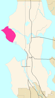
Magnolia, Seattle, Washington
Encyclopedia
Seattle, Washington
Seattle is the county seat of King County, Washington. With 608,660 residents as of the 2010 Census, Seattle is the largest city in the Northwestern United States. The Seattle metropolitan area of about 3.4 million inhabitants is the 15th largest metropolitan area in the country...
by area. It occupies a hilly peninsula northwest of downtown
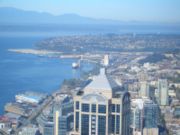
Downtown Seattle
Downtown is the central business district of Seattle, Washington. It is fairly compact compared to other city centers on the West Coast because of its geographical situation: hemmed in on the north and east by hills, on the west by the Elliott Bay, and on the south by reclaimed land that was once...
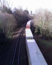
. Magnolia is isolated from the rest of Seattle, connected by road to the rest of the city by only three bridges over the tracks of the BNSF Railway
BNSF Railway
The BNSF Railway is a wholly owned subsidiary of Berkshire Hathaway Inc., and is headquartered in Fort Worth, Texas. It is one of seven North American Class I railroads and the second largest freight railroad network in North America, second only to the Union Pacific Railroad, its primary...
: W. Emerson Place in the north, W. Dravus Street in the center, and W. Garfield Street (the Magnolia Bridge
Magnolia Bridge
The Magnolia Bridge, built in 1930, connects the neighborhoods of Magnolia and Interbay over the filled-in tidelands of Smith Cove. It is one of only three road connections from Magnolia to the rest of Seattle. It carries W. Garfield Street from Magnolia Way W. in the west to the intersection of...
) in the south. It has been a part of the city since 1891. A good portion of the peninsula is taken up by Discovery Park
Discovery Park (Seattle)
Discovery Park is a 534 acre park in the peninsular Magnolia neighborhood of Seattle, Washington. It is the city's largest public park and contains 11.81 miles of walking trails. United Indians of All Tribes' Daybreak Star Cultural Center is within the park's boundaries...
, formerly the U.S. Army's Fort Lawton
Fort Lawton
Fort Lawton is a United States Army fort located in the Magnolia neighborhood of Seattle, Washington. The fort was included in the 2005 Base Realignment and Closure list.-History:...
. Many of the houses near the water or on Viewmont Way house the more wealthy populations of Magnolia.
Magnolia is bounded on the north by Salmon Bay
Salmon Bay
Salmon Bay is that part of the Lake Washington Ship Canal--which passes through the city of Seattle, linking Lake Washington to Puget Sound--that lies west of the Fremont Cut. It is the westernmost section of the canal, and empties into Shilshole Bay, which is part of Puget Sound. Because of the...
and Shilshole Bay
Shilshole Bay
Shilshole Bay is the part of Puget Sound east of a line drawn northeasterly from Seattle's West Point in the southwest to its Golden Gardens Park in the northeast. On its shores lie Discovery Park, the Lawtonwood section of the Magnolia neighborhood, the neighborhood of Ballard, and Golden Gardens...
of the Lake Washington Ship Canal
Lake Washington Ship Canal
The Lake Washington Ship Canal, which runs through the City of Seattle, Washington, connects the fresh water body of Lake Washington with the salt water inland sea of Puget Sound. The Ship Canal includes a series of locks, modeled after the Panama Canal, to accommodate the different water levels...
, across which is Ballard
Ballard, Seattle, Washington
Ballard is a neighborhood located in the northwestern part of Seattle, Washington. To the north it is bounded by Crown Hill, ; to the east by Greenwood, Phinney Ridge and Fremont ; to the south by the Lake Washington Ship Canal; and to the west by Puget Sound’s Shilshole Bay. The neighborhood’s...
; on the west by Puget Sound
Puget Sound
Puget Sound is a sound in the U.S. state of Washington. It is a complex estuarine system of interconnected marine waterways and basins, with one major and one minor connection to the Strait of Juan de Fuca and the Pacific Ocean — Admiralty Inlet being the major connection and...
and Elliott Bay
Elliott Bay
Elliott Bay is the body of water on which Seattle, Washington, is located. A line drawn from Alki Point in the south to West Point in the north serves to mark the generally accepted division between the bay and the open sound...
; on the south by Elliott Bay and Smith Cove
Smith Cove (Washington)
Smith Cove is a body of water, the northern part of Seattle, Washington's Elliott Bay, immediately south of the area that has been known since 1894 as Interbay...
; and on the east by Thorndyke, 20th, and Gilman Avenues W., beyond which is Interbay.
Although magnolia
Magnolia
Magnolia is a large genus of about 210 flowering plant species in the subfamily Magnolioideae of the family Magnoliaceae. It is named after French botanist Pierre Magnol....
trees do line W. McGraw Street in the neighborhood's commercial district, Magnolia's naming was actually a misnomer. While out at sea, Captain Vancouver
George Vancouver
Captain George Vancouver RN was an English officer of the British Royal Navy, best known for his 1791-95 expedition, which explored and charted North America's northwestern Pacific Coast regions, including the coasts of contemporary Alaska, British Columbia, Washington and Oregon...
saw the huge madrona
Arbutus
Arbutus is a genus of at least 14 species of flowering plants in the family Ericaceae, native to warm temperate regions of the Mediterranean, western Europe, and North America.-Description:...
trees atop the peninsula's southern bluffs but mistook them for magnolias and noted this in the ship's log. Groups are actively working to save the remaining madronas on the bluff.
On Magnolia's south end is Magnolia Park, overlooking Puget Sound
Puget Sound
Puget Sound is a sound in the U.S. state of Washington. It is a complex estuarine system of interconnected marine waterways and basins, with one major and one minor connection to the Strait of Juan de Fuca and the Pacific Ocean — Admiralty Inlet being the major connection and...
, Mount Rainier
Mount Rainier
Mount Rainier is a massive stratovolcano located southeast of Seattle in the state of Washington, United States. It is the most topographically prominent mountain in the contiguous United States and the Cascade Volcanic Arc, with a summit elevation of . Mt. Rainier is considered one of the most...
, and the city skyline. It features a picnic area and tennis courts across the street. Also in Magnolia are Smith Cove
Smith Cove (Washington)
Smith Cove is a body of water, the northern part of Seattle, Washington's Elliott Bay, immediately south of the area that has been known since 1894 as Interbay...
and its marina. Discovery Park
Discovery Park (Seattle)
Discovery Park is a 534 acre park in the peninsular Magnolia neighborhood of Seattle, Washington. It is the city's largest public park and contains 11.81 miles of walking trails. United Indians of All Tribes' Daybreak Star Cultural Center is within the park's boundaries...
, in the northwest, encompasses 534 acres (2.2 km²) and is Seattle's largest park. The park is home to eagles, herons, falcons, foxes, and beavers. Seven miles of trails provide visitors with a wilderness experience and views of Puget Sound and the Olympic Mountains
Olympic Mountains
The Olympic Mountains is a mountain range on the Olympic Peninsula of western Washington in the United States. The mountains, part of the Pacific Coast Ranges, are not especially high - Mount Olympus is the highest at - but the western slopes of the Olympics rise directly out of the Pacific...
. Parts of Fort Lawton
Fort Lawton
Fort Lawton is a United States Army fort located in the Magnolia neighborhood of Seattle, Washington. The fort was included in the 2005 Base Realignment and Closure list.-History:...
, such as the officer's homes and other historic buildings, remain in the park.
Adjacent to Discovery Park is West Point
West Point (Seattle)
West Point is the westernmost point in Seattle, Washington, USA, jutting into Puget Sound from the Magnolia neighborhood. It also marks the northern extent of Elliott Bay; a line drawn southeastward to Alki Point marks the western extent of the bay. At the point itself is the 1881 West Point...
, featuring the West Point Lighthouse
West Point Lighthouse
The West Point Light, also known as the Discovery Park Lighthouse, is a 23-foot-high lighthouse on Seattle, Washington's West Point which juts into Puget Sound and marks the northern extent of Elliott Bay. Opening on November 15, 1881, and featuring a fourth-order Fresnel lens, it was the first...
, which was built in 1881 and is the oldest lighthouse in the area. Walking trails descend from the park to two miles (3 km) of beach and the lighthouse. West Point also contains one of Seattle's sewage treatment
Sewage treatment
Sewage treatment, or domestic wastewater treatment, is the process of removing contaminants from wastewater and household sewage, both runoff and domestic. It includes physical, chemical, and biological processes to remove physical, chemical and biological contaminants...
facilities, and several archaeological sites.
Another highlight is the local branch of the Seattle Public Library
Seattle Public Library
The Seattle Public Library is the public library system serving Seattle, Washington, USA. It was officially established by the city in 1890, though there had been efforts to start a Seattle library as early as 1868. There are 26 branches in the system, most of them named after the neighborhoods in...
, designed in 1964 by architects Paul Hayden Kirk and Richard Haag
Richard Haag
Richard Haag is a United States landscape architect. He is famous for his work on Gas Works Park in Seattle, Washington and on the Bloedel Reserve on Bainbridge Island. He is also noted for founding the Landscape Architecture Program at the University of Washington and for holding multiple design...
, who won top awards for design from the American Library Association
American Library Association
The American Library Association is a non-profit organization based in the United States that promotes libraries and library education internationally. It is the oldest and largest library association in the world, with more than 62,000 members....
. In the children's section is a statue of a young girl titled "Girl Holding Doves," designed by Ebba Rapp McLauchlan. Outside hangs a bronze wall sculpture titled "Activity of Thought," an abstract piece of art designed especially for the library by Glenn Alps. The library is furnished with solid walnut tables and chairs custom designed by George Nakashima.
Magnolia's business district, called "Magnolia Village" by locals, is home to many specialty stores and professional services, some of Seattle's top restaurants, and industrial and marine services.
Magnolia Audio Video, a regional electronics retailer now owned by Best Buy
Best Buy
Best Buy Co., Inc. is an American specialty retailer of consumer electronics in the United States, accounting for 19% of the market. It also operates in Mexico, Canada & China. The company's subsidiaries include Geek Squad, CinemaNow, Magnolia Audio Video, Pacific Sales, and, in Canada operates...
, was started in and named after the neighborhood.
Demographics
As of the censusCensus
A census is the procedure of systematically acquiring and recording information about the members of a given population. It is a regularly occurring and official count of a particular population. The term is used mostly in connection with national population and housing censuses; other common...
of 2000, there were 19,156 people, 9,077 households, and 4,828 families residing in the neighborhood. There are 9,416 housing units. The racial makeup of the neighborhood was 87.4% White, 5.8% Asian, 1.6% African American, 0.6% Native American, 0.3% Pacific Islander, 1.0% from other races
Race (United States Census)
Race and ethnicity in the United States Census, as defined by the Federal Office of Management and Budget and the United States Census Bureau, are self-identification data items in which residents choose the race or races with which they most closely identify, and indicate whether or not they are...
, and 3.2% from two or more races. Hispanic or Latino of any race were 3.3% of the population.
There were 9,077 households out of which 20.6% had children under the age of 18 living with them, 45.2% were married couples
Marriage
Marriage is a social union or legal contract between people that creates kinship. It is an institution in which interpersonal relationships, usually intimate and sexual, are acknowledged in a variety of ways, depending on the culture or subculture in which it is found...
living together, 5.8% had a female householder with no husband present, and 46.8% were non-families. 34.8% of all households were made up of individuals and 10.5% had someone living alone who was 65 years of age or older. The average household size was 2.10 and the average family size was 2.73.
In the neighborhood the population was spread out with 17.0% under the age of 18, 7.6% from 18 to 24, 34.8% from 25 to 44, 26.7% from 45 to 64, and 15.3% who were 65 years of age or older. The median age was 40.5 years. For every 100 females there were 93.4 males. For every 100 females age 18 and over, there were 92.2 males.
The median income for a household in the neighborhood was $59,542, and the median income for a family was $79,842. Males had a median income of $51,561 versus $39,107 for females. The per capita income
Per capita income
Per capita income or income per person is a measure of mean income within an economic aggregate, such as a country or city. It is calculated by taking a measure of all sources of income in the aggregate and dividing it by the total population...
for the neighborhood was $37,754. About 2.3% of families and 5.1% of the population were below the poverty line, including 5.3% of those under age 18 and 5.3% of those age 65 or over.