
Santiam State Forest
Encyclopedia
Santiam State Forest is one of six state forests managed by the Oregon Department of Forestry
. The forest is located approximately 25 miles (40.2 km) southeast of Salem
, Oregon
, and includes 47871 acres (193.7 km²) on the western slope of the Cascade Mountains
in three Oregon counties: Clackamas, Linn
, and Marion
. It is bounded on the east by the Willamette National Forest
and Mount Hood National Forest
. Silver Falls State Park
is located west of the forest. The rest of the land surrounding the forest belongs to the Bureau of Land Management
or is privately owned. The forest is managed as part of the Department of Forestry's North Cascade District. It is the largest single block of state owned forest land in the Cascades.
lands and Common School Forest Lands. These lands were acquired from two sources, are controlled by two different state entities and each has a distinct legal mandate that guides its management .
Board of Forestry lands were acquired either through direct purchase or through ownership transfer from Oregon counties in exchange for a portion of the land’s timber revenue. The Department of Forestry manages these forest lands under the direction of the Board of Forestry. By law, these lands are managed to achieve a healthy, productive, and sustainable forest ecosystems that provides the people of Oregon a full range of economic, social, and environmental benefits. The majority of the forest revenue is distributed to Oregon counties and local taxing districts. In the Santiam State Forest, 46827 acres (189.5 km²) i.e. about 98 percent of the land belongs to the Board of Forestry.
When Oregon was granted statehood
in 1859, it received 3500000 acres (14,164 km²) of grazing and forest lands from the Federal Government specifically to support public schools. These lands are known as Common School Forest Lands and are owned by the Oregon State Land Board. The board consists of the Governor of Oregon
, the Oregon Secretary of State
, and the Oregon State Treasurer
. The Department of Forestry manages Common School Forest Lands under a contract with the State Land Board. The purpose of these lands are to generate the greatest amount of revenue over the long run for the Common School Fund consistent with sound land and timber management practices. In the Santiam State Forest, only 887 acres (3.6 km²) i.e. about 2 percent are owned by the State Land Board.
between 1880 and 1930. Most landowners did not reforest the logged areas, leaving the land to regenerate naturally. Forest fires burned large areas as well.
During the Great Depression
, many owners saw little value in these lands and stopped paying taxes on their properties. As a result, counties acquired the land because of delinquent taxes or purchased the land for minimal amounts prior to foreclosure
. Soon after these transactions occurred, the Oregon state legislature began allowing counties to turn their forest lands over to the state Board of Forestry. In exchange, the counties receive a portion of the timber revenue from the land.
Santiam State Forest land in Linn County was acquired by the Board of Forestry between 1939 and 1949. Marion County lands were acquired between 1940 and 1953, and Clackamas County lands were deeded to the state between 1942 and 1950. From 1943 to 1952, the state acquired additional forest land from private land owners through purchases and charitable donations.
By the time ownership passed to the state, natural regeneration had successfully reforested most of the forest. However, a large fire in 1951 burned nearly half the Santiam forest. The Department of Forestry quickly replanted the burned area. Prior to 1968, forest management activities were conducted by workers operating out of the department’s Salem office. In 1968, a new forest headquarters was built in Mehama, Oregon
.
era, 15 million years ago, the area was tilted and cracked resulting in many new lava flows. The rocks that result from this geologic activity are mostly basalt
, andesitic flows, volcanic breccia, and tuff
with smaller amounts of other igneous rocks.
Elevations in Santiam State Forest range from 1,000 to 5000 feet (1,524 m) above sea level. The terrain is characterized by long, steep slopes leading to broad ridge tops. Stream channels are common, and in most cases, have cut deeply into the hills. Higher elevations are rocky, especially on very steep slopes and ridge crests.
 The Santiam State Forest has a temperate mountain climate. Late fall and winter seasons are normally wet, receives approximately 70 inches (1,778 mm) of precipitation per year. In winter, snow accumulation is not heavy except at the highest elevations. Summers are generally dry and warm. Extremely hot days are rare.
Portions of the Santiam State Forest are located within the community watershed
areas for a number of Oregon cities including Detroit
, Gates
, Mehama, Lyons
, Mills City
, Salem, Stayton
, Scotts Mill
, and Silverton
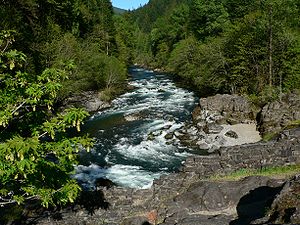
. In the southern area of the forest, the major streams are Rock Creek, Mad Creek, Snake Creek, Sardine Creek, and Stout Creek, which all flow into the North Santiam River
. Major streams in the north are Butte Creek
, Abiqua Creek
, Cedar Creek, and Silver Creek. These creeks all flow into the Pudding River
. In addition, Gawley Creek flows into the Molalla River
.
The Santiam State Forest contains a few scattered wetlands, all smaller than 10 acres (40,468.6 m²). There are four high elevation lakes located within the Butte Creek Basin. These lakes provide important wildlife habitat, but are also popular recreation sites.
The Santiam State Forest is home to large, healthy populations of deer
, elk
, cougar, and bear
. The North Cascade District conducts an annual spotted owl
survey in the Santiam State Forest to monitor the owl population and habitat. The results of the survey show a small, but stable population of spotted owls are located within the forest.
There are 63 miles (101.4 km) of fish bearing streams located on the Santiam State Forest with an additional 78 miles (125.5 km) of streams that have not yet been classified. The North Cascade District is currently conducting fish presence surveys in order to classify the remaining streams. Completed stream inventories show the presence of both rainbow trout
and cutthroat trout
. The lower reaches of Rock Creek, Mad Creek, and Stout Creek also support populations of wild winter steelhead.
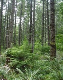 Douglas-fir
is the primary tree species in the Santiam State Forest. In some areas, the Douglas-fir stands are mixed with western hemlock
, western red cedar, red alder
, and bigleaf maple
. A few Pacific yew can also be found at the lower elevations. Mountain hemlock
, noble fir
, silver fir
, and western white pine
are found in the higher elevations. Douglas-fir areas that have been recently cut and reforested are characterized by even-aged layers of seedlings or saplings. Stands cut more than 15 years ago have grown into closed canopy stands. These areas have a dense, even-aged layer of rapidly growing Douglas fir trees. The forest also has some older stands that naturally regenerated prior to the establishment of the state forest. These areas are typically mixed conifer stands that include Douglas-fir, hemlock, western red cedar, and noble fir. The forest has only a few layered stands, approximately 8500 acres (34.4 km²). These are the result of a selective cutting program during the 1970s and 1980s. These stands normally have an over-story of large Douglas-fir trees. There are ten separate patches of old-growth forest, totaling 380 acres (1.5 km²). These stands range in age from 120 to 500 years old.
The Santiam State Forest has seven management basins delineated by major stream drainage areas and related land forms. The Butte Creek Basin has 10074 acres (40.8 km²), and is located southeast of Silverton. The Cedar Creek Basin has 4229 acres (17.1 km²), and is northeast of Silver Falls State Park. The Crabtree Basin has 1890 acres (7.6 km²), and is located east of Lebanon, Oregon
. The Green Basin has 6905 acres (27.9 km²), and is northeast of Gates. The Mad Creek Basin has 6737 acres (27.3 km²), and is located southeast of Mill City. The Rock Creek Basin has 12603 acres (51 km²), and is located south of Mill City adjacent to the Mad Creek Basin. There is also a forest unit designated as the Scattered Basin. That unit has 5276 acres (21.4 km²) located in scattered parcels throughout Clackamas, Marion, and Linn counties. These areas drain into the North Santiam River, South Santiam River
, or the Pudding River
.
, hunting
, fishing
, mountain biking
, and horseback riding
. The forest has five campgrounds, a number of maintained day-use areas, and 21 miles (33.8 km) of hiking trails. One of the most popular sites is Shellburg Falls, located off Highway 22 near the town of Mehama. It has a quarter-mile hiking trail leading to the falls. It also has a one-half mile mountain bike trail constructed in 2006. Green Basin has two primitive hiking trails. One trail leads to the peak of Rocky Top Mountain where a fire lookout
was once located. The other trail leads to a natural rock arch. Both of these trails are about one-half mile long. In the Butte Creek management area a short trail leads to Butte Creek Falls. The North Cascade District posts hiking information on kiosks at all the trailheads.
Oregon State Police
troopers conduct vehicle patrols and provide law enforcement on the Santiam State Forest lands. Patrols enforce fish and wildlife, trespass, vandalism, and other state laws as well as fire regulations. Department of Forestry officers also patrol recreation areas and provide visitor assistance during high use periods.
Oregon Department of Forestry
The Oregon Department of Forestry is the agency of the government of the U.S. state of Oregon which performs a wide variety of functions relating to the management, regulation and protection of both public and private forest lands in the state...
. The forest is located approximately 25 miles (40.2 km) southeast of Salem
Salem, Oregon
Salem is the capital of the U.S. state of Oregon, and the county seat of Marion County. It is located in the center of the Willamette Valley alongside the Willamette River, which runs north through the city. The river forms the boundary between Marion and Polk counties, and the city neighborhood...
, Oregon
Oregon
Oregon is a state in the Pacific Northwest region of the United States. It is located on the Pacific coast, with Washington to the north, California to the south, Nevada on the southeast and Idaho to the east. The Columbia and Snake rivers delineate much of Oregon's northern and eastern...
, and includes 47871 acres (193.7 km²) on the western slope of the Cascade Mountains
Cascade Range
The Cascade Range is a major mountain range of western North America, extending from southern British Columbia through Washington and Oregon to Northern California. It includes both non-volcanic mountains, such as the North Cascades, and the notable volcanoes known as the High Cascades...
in three Oregon counties: Clackamas, Linn
Linn County, Oregon
Linn County is a county located in the U.S. state of Oregon. It is named in honor of Lewis F. Linn, a U.S. Senator from Missouri who advocated the American occupation of the Oregon Country. By the 2010 US census the population of Linn county was 116,672 showing a 13.2% growth since the 2000 census...
, and Marion
Marion County, Oregon
Marion County is a county located in the U.S. state of Oregon. It was originally named the Champooick District, after Champoeg, a meeting place on the Willamette River. On September 3, 1849, the territorial legislature renamed it in honor of Francis Marion, a Continental Army general of the...
. It is bounded on the east by the Willamette National Forest
Willamette National Forest
The Willamette National Forest is a National Forest located in the central portion of the Cascade Range of US state of Oregon.It comprises 1,675,407 acres making it one of the largest national forests. Over 380,000 acres are designated wilderness which include seven major mountain peaks...
and Mount Hood National Forest
Mount Hood National Forest
The Mount Hood National Forest is located east of the city of Portland, Oregon, and the northern Willamette River valley. The Forest extends south from the Columbia River Gorge across more than of forested mountains, lakes and streams to the Olallie Scenic Area, a high lake basin under the slopes...
. Silver Falls State Park
Silver Falls State Park
Silver Falls State Park is a state park in the U.S. state of Oregon, located near Silverton, about east-southeast of Salem. It is the largest state park in Oregon with an area of more than , and it includes more than of walking trails, of horse trails, and a bike path...
is located west of the forest. The rest of the land surrounding the forest belongs to the Bureau of Land Management
Bureau of Land Management
The Bureau of Land Management is an agency within the United States Department of the Interior which administers America's public lands, totaling approximately , or one-eighth of the landmass of the country. The BLM also manages of subsurface mineral estate underlying federal, state and private...
or is privately owned. The forest is managed as part of the Department of Forestry's North Cascade District. It is the largest single block of state owned forest land in the Cascades.
Forest ownership
Oregon state forests consist of two types of land, Oregon Board of ForestryOregon Board of Forestry
The Oregon Board of Forestry is responsible for forest policy and oversight of forest management practices within the state of Oregon. The board appoints the state forester and oversees the Oregon Department of Forestry...
lands and Common School Forest Lands. These lands were acquired from two sources, are controlled by two different state entities and each has a distinct legal mandate that guides its management .
Board of Forestry lands were acquired either through direct purchase or through ownership transfer from Oregon counties in exchange for a portion of the land’s timber revenue. The Department of Forestry manages these forest lands under the direction of the Board of Forestry. By law, these lands are managed to achieve a healthy, productive, and sustainable forest ecosystems that provides the people of Oregon a full range of economic, social, and environmental benefits. The majority of the forest revenue is distributed to Oregon counties and local taxing districts. In the Santiam State Forest, 46827 acres (189.5 km²) i.e. about 98 percent of the land belongs to the Board of Forestry.
When Oregon was granted statehood
U.S. state
A U.S. state is any one of the 50 federated states of the United States of America that share sovereignty with the federal government. Because of this shared sovereignty, an American is a citizen both of the federal entity and of his or her state of domicile. Four states use the official title of...
in 1859, it received 3500000 acres (14,164 km²) of grazing and forest lands from the Federal Government specifically to support public schools. These lands are known as Common School Forest Lands and are owned by the Oregon State Land Board. The board consists of the Governor of Oregon
Governor of Oregon
The Governor of Oregon is the top executive of the government of the U.S. state of Oregon. The title of governor was also applied to the office of Oregon's chief executive during the provisional and U.S. territorial governments....
, the Oregon Secretary of State
Oregon Secretary of State
The Secretary of State of Oregon, an elected constitutional officer within the executive branch of government of the U.S. state of Oregon, is first in line of succession to the Governor. The duties of office are: auditor of public accounts, chief elections officer, and administrator of public...
, and the Oregon State Treasurer
Oregon State Treasurer
The Oregon State Treasurer is a constitutional officer within the executive branch of the government of the U.S. state of Oregon, elected by statewide vote to serve a four year term. As chief financial officer for the state, the office holder heads the Oregon State Treasury, and with the Governor...
. The Department of Forestry manages Common School Forest Lands under a contract with the State Land Board. The purpose of these lands are to generate the greatest amount of revenue over the long run for the Common School Fund consistent with sound land and timber management practices. In the Santiam State Forest, only 887 acres (3.6 km²) i.e. about 2 percent are owned by the State Land Board.
History
Most of the land that makes up the Santiam State Forest was originally owned by large timber companies, often associated with railroads. The forest was heavily loggedLogging
Logging is the cutting, skidding, on-site processing, and loading of trees or logs onto trucks.In forestry, the term logging is sometimes used in a narrow sense concerning the logistics of moving wood from the stump to somewhere outside the forest, usually a sawmill or a lumber yard...
between 1880 and 1930. Most landowners did not reforest the logged areas, leaving the land to regenerate naturally. Forest fires burned large areas as well.
During the Great Depression
Great Depression
The Great Depression was a severe worldwide economic depression in the decade preceding World War II. The timing of the Great Depression varied across nations, but in most countries it started in about 1929 and lasted until the late 1930s or early 1940s...
, many owners saw little value in these lands and stopped paying taxes on their properties. As a result, counties acquired the land because of delinquent taxes or purchased the land for minimal amounts prior to foreclosure
Foreclosure
Foreclosure is the legal process by which a mortgage lender , or other lien holder, obtains a termination of a mortgage borrower 's equitable right of redemption, either by court order or by operation of law...
. Soon after these transactions occurred, the Oregon state legislature began allowing counties to turn their forest lands over to the state Board of Forestry. In exchange, the counties receive a portion of the timber revenue from the land.
Santiam State Forest land in Linn County was acquired by the Board of Forestry between 1939 and 1949. Marion County lands were acquired between 1940 and 1953, and Clackamas County lands were deeded to the state between 1942 and 1950. From 1943 to 1952, the state acquired additional forest land from private land owners through purchases and charitable donations.
By the time ownership passed to the state, natural regeneration had successfully reforested most of the forest. However, a large fire in 1951 burned nearly half the Santiam forest. The Department of Forestry quickly replanted the burned area. Prior to 1968, forest management activities were conducted by workers operating out of the department’s Salem office. In 1968, a new forest headquarters was built in Mehama, Oregon
Mehama, Oregon
Mehama is an unincorporated community in Marion County, Oregon, United States, located on Oregon Route 22 and the North Santiam River. For statistical purposes, the United States Census Bureau has defined Mehama as a census-designated place . The census definition of the area may not precisely...
.
Topography
Santiam State Forest geologic history began 40 million years ago with the eruption of a chain of volcanos, today’s Cascade Mountains. During the MioceneMiocene
The Miocene is a geological epoch of the Neogene Period and extends from about . The Miocene was named by Sir Charles Lyell. Its name comes from the Greek words and and means "less recent" because it has 18% fewer modern sea invertebrates than the Pliocene. The Miocene follows the Oligocene...
era, 15 million years ago, the area was tilted and cracked resulting in many new lava flows. The rocks that result from this geologic activity are mostly basalt
Basalt
Basalt is a common extrusive volcanic rock. It is usually grey to black and fine-grained due to rapid cooling of lava at the surface of a planet. It may be porphyritic containing larger crystals in a fine matrix, or vesicular, or frothy scoria. Unweathered basalt is black or grey...
, andesitic flows, volcanic breccia, and tuff
Tuff
Tuff is a type of rock consisting of consolidated volcanic ash ejected from vents during a volcanic eruption. Tuff is sometimes called tufa, particularly when used as construction material, although tufa also refers to a quite different rock. Rock that contains greater than 50% tuff is considered...
with smaller amounts of other igneous rocks.
Elevations in Santiam State Forest range from 1,000 to 5000 feet (1,524 m) above sea level. The terrain is characterized by long, steep slopes leading to broad ridge tops. Stream channels are common, and in most cases, have cut deeply into the hills. Higher elevations are rocky, especially on very steep slopes and ridge crests.
Water resources
Portions of the Santiam State Forest are located within the community watershed
Drainage basin
A drainage basin is an extent or an area of land where surface water from rain and melting snow or ice converges to a single point, usually the exit of the basin, where the waters join another waterbody, such as a river, lake, reservoir, estuary, wetland, sea, or ocean...
areas for a number of Oregon cities including Detroit
Detroit, Oregon
Detroit is a city in Marion County, Oregon, United States. It was named for Detroit, Michigan in the 1890s because of the large number of people from Michigan in the community. The population was 262 at the 2000 census...
, Gates
Gates, Oregon
Gates is a city on the border of Linn and Marion counties in Oregon, United States. The population was 471 at the 2000 census. The greater part of Gates' population is in Marion County and the city is primarily under Marion County's jurisdiction...
, Mehama, Lyons
Lyons, Oregon
Lyons is a city in Linn County, Oregon, United States. The population was 1,008 at the 2000 census. The center of population of Oregon is located in Lyons.-Geography:...
, Mills City
Mill City, Oregon
Mill City is a city in Linn and Marion counties in the U.S. state of Oregon. The population was 1,537 at the 2000 census. It is on the North Santiam River, downstream from Detroit Lake....
, Salem, Stayton
Stayton, Oregon
Stayton is a city in Marion County, Oregon, United States, located southeast of the state capital, Salem, on Oregon Route 22. It is south of Sublimity and east of Aumsville. Located on the North Santiam River, Stayton is a regional agricultural and light manufacturing center. The population was...
, Scotts Mill
Scotts Mills, Oregon
Scotts Mills is a city in Marion County, Oregon, United States. The population was 312 at the 2000 census. It is two miles south of Marquam and Oregon Route 213, between Silverton and Molalla.Scotts Mills is part of the Salem Metropolitan Statistical Area...
, and Silverton
Silverton, Oregon
Silverton is a city in Marion County, Oregon, United States, along the 45th parallel. The population was 7,414 at the 2000 census. It is part of the Salem Metropolitan Statistical Area.-Geography:...
. In the southern area of the forest, the major streams are Rock Creek, Mad Creek, Snake Creek, Sardine Creek, and Stout Creek, which all flow into the North Santiam River
North Santiam River
The North Santiam River is a tributary of the Santiam River in western Oregon in the United States. It drains of the Cascade Range on the eastern side of the Willamette Valley east of Salem....
. Major streams in the north are Butte Creek
Butte Creek (Oregon)
Butte Creek is a stream in the U.S. state of Oregon, a tributary of the Pudding River. It is approximately long and, for all of its course, defines part of the northeastern boundary of Marion County and the southern boundary of Clackamas County.- Course :...
, Abiqua Creek
Abiqua Creek
Abiqua Creek is a tributary of the Pudding River in the U.S. state of Oregon. The creek originates near Lookout Mountain in the foothills of the Cascade Range in the northwestern part of the state. It flows northwest for about to its confluence with the Pudding, about west of Silverton, in the...
, Cedar Creek, and Silver Creek. These creeks all flow into the Pudding River
Pudding River
The Pudding River is a tributary of the Molalla River in the U.S. state of Oregon. Its drainage basin covers . Among its tributaries is the Little Pudding River...
. In addition, Gawley Creek flows into the Molalla River
Molalla River
The Molalla River is a tributary of the Willamette River in the U.S. state of Oregon.-Geography:Its headwaters are in Clackamas County, in the Table Rock Wilderness, near Table Rock, in the Cascade Range...
.
The Santiam State Forest contains a few scattered wetlands, all smaller than 10 acres (40,468.6 m²). There are four high elevation lakes located within the Butte Creek Basin. These lakes provide important wildlife habitat, but are also popular recreation sites.
Wildlife
The forests of northwest Oregon provide habitat for hundreds of species of fish and wildlife. A total of 270 species including 63 are mammals, 147 birds, 32 amphibians and reptiles, and 28 fish species are known to live in or near state forest lands. Many of these species have ranges that include the Santiam State Forest.The Santiam State Forest is home to large, healthy populations of deer
Deer
Deer are the ruminant mammals forming the family Cervidae. Species in the Cervidae family include white-tailed deer, elk, moose, red deer, reindeer, fallow deer, roe deer and chital. Male deer of all species and female reindeer grow and shed new antlers each year...
, elk
Elk
The Elk is the large deer, also called Cervus canadensis or wapiti, of North America and eastern Asia.Elk may also refer to:Other antlered mammals:...
, cougar, and bear
American black bear
The American black bear is a medium-sized bear native to North America. It is the continent's smallest and most common bear species. Black bears are omnivores, with their diets varying greatly depending on season and location. They typically live in largely forested areas, but do leave forests in...
. The North Cascade District conducts an annual spotted owl
Spotted Owl
The Spotted Owl, Strix occidentalis, is a species of true owl. It is a resident species of forests in western North America, where it nests in tree holes, old bird of prey nests, or rock crevices. Nests can be between 13 and 66 yards high and usually contain two eggs...
survey in the Santiam State Forest to monitor the owl population and habitat. The results of the survey show a small, but stable population of spotted owls are located within the forest.
There are 63 miles (101.4 km) of fish bearing streams located on the Santiam State Forest with an additional 78 miles (125.5 km) of streams that have not yet been classified. The North Cascade District is currently conducting fish presence surveys in order to classify the remaining streams. Completed stream inventories show the presence of both rainbow trout
Rainbow trout
The rainbow trout is a species of salmonid native to tributaries of the Pacific Ocean in Asia and North America. The steelhead is a sea run rainbow trout usually returning to freshwater to spawn after 2 to 3 years at sea. In other words, rainbow trout and steelhead trout are the same species....
and cutthroat trout
Cutthroat trout
The cutthroat trout is a species of freshwater fish in the salmon family of order Salmoniformes. It is one of the many fish species colloquially known as trout...
. The lower reaches of Rock Creek, Mad Creek, and Stout Creek also support populations of wild winter steelhead.
Forest management
North Cascade District operates under a forest management plan that included timber harvesting at a rate of 2000 acres (8.1 km²) to 3000 acres (12.1 km²) per year. Clear cut harvesting is limited to 200 acre (0.809372 km²) per year. Two important factors that influence the timber harvest are restrictions for spotted owl habitat and the emerging market for smaller-diameter saw-logs and veneer material.Douglas-fir
Douglas-fir is one of the English common names for evergreen coniferous trees of the genus Pseudotsuga in the family Pinaceae. Other common names include Douglas tree, and Oregon pine. There are five species, two in western North America, one in Mexico, and two in eastern Asia...
is the primary tree species in the Santiam State Forest. In some areas, the Douglas-fir stands are mixed with western hemlock
Western Hemlock
Tsuga heterophylla. the Western Hemlock, is a species of hemlock native to the west coast of North America, with its northwestern limit on the Kenai Peninsula, Alaska, and its southeastern limit in northern Sonoma County, California.-Habitat:...
, western red cedar, red alder
Red Alder
Alnus rubra, the Red alder, is a deciduous broadleaf tree native to western North America.-Description:It is the largest species of alder in North America and one of the largest in the world, reaching heights of 20–35 m. The official tallest red alder stands 32 meters tall in Clatsop County, Oregon...
, and bigleaf maple
Bigleaf Maple
Acer macrophyllum is a large deciduous tree in the genus Acer.It can grow to be up to 35 m tall, but more commonly grows 15 m to 20 m tall. It is native to western North America, mostly near the Pacific coast, from southernmost Alaska to southern California...
. A few Pacific yew can also be found at the lower elevations. Mountain hemlock
Mountain Hemlock
Tsuga mertensiana, known as Mountain Hemlock, is a species of hemlock native to the west coast of North America, with its northwestern limit on the Kenai Peninsula, Alaska, and its southeastern limit in northern Tulare County, California....
, noble fir
Noble Fir
Abies procera, the Noble Fir, is a western North American fir, native to the Cascade Range and Coast Range mountains of extreme northwest California and western Oregon and Washington in the United States...
, silver fir
Silver Fir
Abies alba, commonly known as the European silver fir, is a fir native to the mountains of Europe, from the Pyrenees north to Normandy, east to the Alps and the Carpathians, and south to southern Italy and northern Serbia.-Description:...
, and western white pine
Western White Pine
Western White Pine, Pinus monticola in the family Pinaceae, is a species of pine that occurs in the mountains of the western United States and Canada, specifically the Sierra Nevada, the Cascade Range, the Coast Range, and the northern Rocky Mountains. The tree extends down to sea level in many...
are found in the higher elevations. Douglas-fir areas that have been recently cut and reforested are characterized by even-aged layers of seedlings or saplings. Stands cut more than 15 years ago have grown into closed canopy stands. These areas have a dense, even-aged layer of rapidly growing Douglas fir trees. The forest also has some older stands that naturally regenerated prior to the establishment of the state forest. These areas are typically mixed conifer stands that include Douglas-fir, hemlock, western red cedar, and noble fir. The forest has only a few layered stands, approximately 8500 acres (34.4 km²). These are the result of a selective cutting program during the 1970s and 1980s. These stands normally have an over-story of large Douglas-fir trees. There are ten separate patches of old-growth forest, totaling 380 acres (1.5 km²). These stands range in age from 120 to 500 years old.
The Santiam State Forest has seven management basins delineated by major stream drainage areas and related land forms. The Butte Creek Basin has 10074 acres (40.8 km²), and is located southeast of Silverton. The Cedar Creek Basin has 4229 acres (17.1 km²), and is northeast of Silver Falls State Park. The Crabtree Basin has 1890 acres (7.6 km²), and is located east of Lebanon, Oregon
Lebanon, Oregon
Lebanon is a city in Linn County, Oregon, United States. Lebanon is located in northwest Oregon, southeast of Salem. The population was 12,950 at the 2000 census and the 2008 census data shows the population at 15,397.-Geography:...
. The Green Basin has 6905 acres (27.9 km²), and is northeast of Gates. The Mad Creek Basin has 6737 acres (27.3 km²), and is located southeast of Mill City. The Rock Creek Basin has 12603 acres (51 km²), and is located south of Mill City adjacent to the Mad Creek Basin. There is also a forest unit designated as the Scattered Basin. That unit has 5276 acres (21.4 km²) located in scattered parcels throughout Clackamas, Marion, and Linn counties. These areas drain into the North Santiam River, South Santiam River
South Santiam River
The South Santiam River is a tributary of the Santiam River, about long, in western Oregon in the United States. It drains an area of the Cascade Range into the Willamette Valley east of Corvallis....
, or the Pudding River
Pudding River
The Pudding River is a tributary of the Molalla River in the U.S. state of Oregon. Its drainage basin covers . Among its tributaries is the Little Pudding River...
.
Recreation
Santiam State Forest is used for a wide range recreation activities including campingCamping
Camping is an outdoor recreational activity. The participants leave urban areas, their home region, or civilization and enjoy nature while spending one or several nights outdoors, usually at a campsite. Camping may involve the use of a tent, caravan, motorhome, cabin, a primitive structure, or no...
, hunting
Hunting
Hunting is the practice of pursuing any living thing, usually wildlife, for food, recreation, or trade. In present-day use, the term refers to lawful hunting, as distinguished from poaching, which is the killing, trapping or capture of the hunted species contrary to applicable law...
, fishing
Fishing
Fishing is the activity of trying to catch wild fish. Fish are normally caught in the wild. Techniques for catching fish include hand gathering, spearing, netting, angling and trapping....
, mountain biking
Mountain biking
Mountain biking is a sport which consists of riding bicycles off-road, often over rough terrain, using specially adapted mountain bikes. Mountain bikes share similarities with other bikes, but incorporate features designed to enhance durability and performance in rough terrain.Mountain biking can...
, and horseback riding
Trail riding
Trail riding sometimes called horse or pony trekking is riding outdoors on natural trails and roads as opposed to riding in an enclosed area such as a riding arena. The term may encompass those who travel on horses, on mountain bikes, or on motorcycles and other motorized all-terrain vehicles...
. The forest has five campgrounds, a number of maintained day-use areas, and 21 miles (33.8 km) of hiking trails. One of the most popular sites is Shellburg Falls, located off Highway 22 near the town of Mehama. It has a quarter-mile hiking trail leading to the falls. It also has a one-half mile mountain bike trail constructed in 2006. Green Basin has two primitive hiking trails. One trail leads to the peak of Rocky Top Mountain where a fire lookout
Fire lookout
A fire lookout is a person assigned the duty to look for fire from atop a building known as a fire lookout tower. These towers are used in remote areas, normally on mountain tops with high elevation and a good view of the surrounding terrain, to spot smoke caused by a wildfire.Once a possible fire...
was once located. The other trail leads to a natural rock arch. Both of these trails are about one-half mile long. In the Butte Creek management area a short trail leads to Butte Creek Falls. The North Cascade District posts hiking information on kiosks at all the trailheads.
Oregon State Police
Oregon State Police
The Oregon State Police is the main state law enforcement agency of the U.S. state of Oregon. They have been charged to enforce all of Oregon's criminal laws and to help local law enforcement agencies with their duties...
troopers conduct vehicle patrols and provide law enforcement on the Santiam State Forest lands. Patrols enforce fish and wildlife, trespass, vandalism, and other state laws as well as fire regulations. Department of Forestry officers also patrol recreation areas and provide visitor assistance during high use periods.