
Silver Falls State Park
Encyclopedia
Silver Falls State Park is a state park
in the U.S. state
of Oregon
, located near Silverton
, about 20 miles (32.2 km) east-southeast of Salem
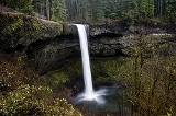
. It is the largest state park in Oregon with an area of more than 9000 acres (36.4 km²), and it includes more than 24 miles (38.6 km) of walking trails, 14 miles (22.5 km) of horse trails, and a 4 miles (6.4 km) bike path. Its 8.7 miles (14 km) Canyon Trail/Trail of Ten Falls runs along the banks of Silver Creek
and by ten waterfall
s, from which the park received its name. Four of the ten falls have an amphitheater-like surrounding that allows the trail to pass behind the flow of the falls. The Silver Falls State Park Concession Building Area and the Silver Creek Youth Camp-Silver Falls State Park are separately listed on the U.S. National Register of Historic Places
.
The park's most visited waterfall is South Falls, a 177 feet (53.9 m) cascade. Remote Double Falls, however, is listed as the highest waterfall in the park, plunging 178 feet (54.3 m) in a small tributary side canyon deep within the Silver Creek Canyon.
community with a few homesteaders, and the area was extensively logged. By 1900 a Silverton
photographer, June D. Drake, began to campaign for park status, using his photographs of the falls to gain support. (Drake Falls was later named for him.) In 1926, however, an inspector for the National Park Service
rejected the area for park status because of a proliferation of unattractive stumps.
In 1935 President Franklin D. Roosevelt
announced that the Silver Falls area would be turned into a Recreational Demonstration Area
. Private land that had been logged was purchased, and workers in the Civilian Conservation Corps
were employed to develop park facilities, including the historic South Falls Lodge, completed in the late 1930s. It was used as a restaurant from 1946 until the late 1950s and was listed on the National Register of Historic Places
as the Silver Falls State Park Concession Building Area in 1983. The Silver Creek Youth Camp—Silver Falls State Park was also added to the National Register at this time.
In January 2008, during the 2008 supplemental legislative session, Fred Girod
of the Oregon House of Representatives
sought federal designation of the area as a national park
via a house joint memorial to the United States Congress
, but the bill died in committee.
period, when most of Oregon
was covered by ocean. After the waters of the ocean receded about 15 million years ago, the flood basalt
flows of the Columbia River Basalt Group
covered the sandstone
that had been the ocean floor. The softer layers of sandstone
beneath the basalt sheet eroded over time, creating pathways behind some of the waterfalls which Civilian Conservation Corps
workers widened to make safe for public use. Another geologic feature are many tree "chimneys" or casts, formed when hot lava engulfed living trees and disintegrated them.
. Most trout in both forks run quite small with the average catch usually in the 5-9 inch range. A large fish in these waters runs 12 inches (304.8 mm) though on rare occasion a larger fish will show up. The confluence of the forks is deep in the canyon and not accessible by trail. However for the adventurous angler there are good opportunities for slightly larger trout than inhabit the forks above. The best stretches to fish are the creek below the confluence and the North Fork as it generally carries more water. The best time to fish is usually the first few weeks after the season opens in late May and then again after the first fall rains usually in September. You will not likely catch large fish at Silver Creek Falls, but with a little hard work and some wading there are plenty of fish to be caught adding yet another dimension to this dynamic park.
As a result, this private and public partnership has created a more meaningful park experience for the nearly one million annual visitors to the park, far beyond what state park funding alone can provide.
Since 1992, volunteers of the Friends of Silver Falls State Park have operated the Nature Store in historic South Falls Lodge. This store offers a variety of books, clothing and souvenirs in keeping with the park's nature theme. The organization has also been responsible for much of the interpretive signage along the Trail of Ten Falls.
Other goals of the Friends include compiling oral histories from those who have memories of the park region, keeping alive the history of Silver Falls City, recognizing the work of the Civilian Conservation Corps and the Works Progress Administration
in the 1930s and 1940s, maintaining the park's historic district, and continuing to place interpretive signs throughout the park's more than 9000 acres (36.4 km²).
State park
State parks are parks or other protected areas managed at the federated state level within those nations which use "state" as a political subdivision. State parks are typically established by a state to preserve a location on account of its natural beauty, historic interest, or recreational...
in the U.S. state
U.S. state
A U.S. state is any one of the 50 federated states of the United States of America that share sovereignty with the federal government. Because of this shared sovereignty, an American is a citizen both of the federal entity and of his or her state of domicile. Four states use the official title of...
of Oregon
Oregon
Oregon is a state in the Pacific Northwest region of the United States. It is located on the Pacific coast, with Washington to the north, California to the south, Nevada on the southeast and Idaho to the east. The Columbia and Snake rivers delineate much of Oregon's northern and eastern...
, located near Silverton
Silverton, Oregon
Silverton is a city in Marion County, Oregon, United States, along the 45th parallel. The population was 7,414 at the 2000 census. It is part of the Salem Metropolitan Statistical Area.-Geography:...
, about 20 miles (32.2 km) east-southeast of Salem
Salem, Oregon
Salem is the capital of the U.S. state of Oregon, and the county seat of Marion County. It is located in the center of the Willamette Valley alongside the Willamette River, which runs north through the city. The river forms the boundary between Marion and Polk counties, and the city neighborhood...
. It is the largest state park in Oregon with an area of more than 9000 acres (36.4 km²), and it includes more than 24 miles (38.6 km) of walking trails, 14 miles (22.5 km) of horse trails, and a 4 miles (6.4 km) bike path. Its 8.7 miles (14 km) Canyon Trail/Trail of Ten Falls runs along the banks of Silver Creek
Silver Creek (Marion County, Oregon)
Silver Creek is a stream in Marion County, Oregon, United States. It is a tributary of the Pudding River and originates in Silver Falls State Park in the Cascade foothills above the cities Silverton and Stayton.-Course:...
and by ten waterfall
Waterfall
A waterfall is a place where flowing water rapidly drops in elevation as it flows over a steep region or a cliff.-Formation:Waterfalls are commonly formed when a river is young. At these times the channel is often narrow and deep. When the river courses over resistant bedrock, erosion happens...
s, from which the park received its name. Four of the ten falls have an amphitheater-like surrounding that allows the trail to pass behind the flow of the falls. The Silver Falls State Park Concession Building Area and the Silver Creek Youth Camp-Silver Falls State Park are separately listed on the U.S. National Register of Historic Places
National Register of Historic Places
The National Register of Historic Places is the United States government's official list of districts, sites, buildings, structures, and objects deemed worthy of preservation...
.
The park's most visited waterfall is South Falls, a 177 feet (53.9 m) cascade. Remote Double Falls, however, is listed as the highest waterfall in the park, plunging 178 feet (54.3 m) in a small tributary side canyon deep within the Silver Creek Canyon.
History
Silver Falls City formed in 1888 and was primarily a loggingLogging
Logging is the cutting, skidding, on-site processing, and loading of trees or logs onto trucks.In forestry, the term logging is sometimes used in a narrow sense concerning the logistics of moving wood from the stump to somewhere outside the forest, usually a sawmill or a lumber yard...
community with a few homesteaders, and the area was extensively logged. By 1900 a Silverton
Silverton, Oregon
Silverton is a city in Marion County, Oregon, United States, along the 45th parallel. The population was 7,414 at the 2000 census. It is part of the Salem Metropolitan Statistical Area.-Geography:...
photographer, June D. Drake, began to campaign for park status, using his photographs of the falls to gain support. (Drake Falls was later named for him.) In 1926, however, an inspector for the National Park Service
National Park Service
The National Park Service is the U.S. federal agency that manages all national parks, many national monuments, and other conservation and historical properties with various title designations...
rejected the area for park status because of a proliferation of unattractive stumps.
In 1935 President Franklin D. Roosevelt
Franklin D. Roosevelt
Franklin Delano Roosevelt , also known by his initials, FDR, was the 32nd President of the United States and a central figure in world events during the mid-20th century, leading the United States during a time of worldwide economic crisis and world war...
announced that the Silver Falls area would be turned into a Recreational Demonstration Area
Recreational Demonstration Area
The Recreational Demonstration Area program was a National Park Service program during the 1930s and early 1940s that built forty-six public parks in twenty-four states on , chiefly near urban areas in the United States...
. Private land that had been logged was purchased, and workers in the Civilian Conservation Corps
Civilian Conservation Corps
The Civilian Conservation Corps was a public work relief program that operated from 1933 to 1942 in the United States for unemployed, unmarried men from relief families, ages 18–25. A part of the New Deal of President Franklin D...
were employed to develop park facilities, including the historic South Falls Lodge, completed in the late 1930s. It was used as a restaurant from 1946 until the late 1950s and was listed on the National Register of Historic Places
National Register of Historic Places
The National Register of Historic Places is the United States government's official list of districts, sites, buildings, structures, and objects deemed worthy of preservation...
as the Silver Falls State Park Concession Building Area in 1983. The Silver Creek Youth Camp—Silver Falls State Park was also added to the National Register at this time.
In January 2008, during the 2008 supplemental legislative session, Fred Girod
Fred Girod
Fred Girod is a Republican politician from the U.S. state of Oregon. He serves in the Oregon State Senate representing District 9, in the mid-Willamette Valley, and lives in Stayton....
of the Oregon House of Representatives
Oregon House of Representatives
The Oregon House of Representatives is the lower house of the Oregon Legislative Assembly. There are 60 members of the House, representing 60 districts across the state, each with a population of 57,000. The House meets at the Oregon State Capitol in Salem....
sought federal designation of the area as a national park
National park
A national park is a reserve of natural, semi-natural, or developed land that a sovereign state declares or owns. Although individual nations designate their own national parks differently A national park is a reserve of natural, semi-natural, or developed land that a sovereign state declares or...
via a house joint memorial to the United States Congress
United States Congress
The United States Congress is the bicameral legislature of the federal government of the United States, consisting of the Senate and the House of Representatives. The Congress meets in the United States Capitol in Washington, D.C....
, but the bill died in committee.
Geology
The history of the canyon's formation begins about 26 million years ago to the OligoceneOligocene
The Oligocene is a geologic epoch of the Paleogene Period and extends from about 34 million to 23 million years before the present . As with other older geologic periods, the rock beds that define the period are well identified but the exact dates of the start and end of the period are slightly...
period, when most of Oregon
Oregon
Oregon is a state in the Pacific Northwest region of the United States. It is located on the Pacific coast, with Washington to the north, California to the south, Nevada on the southeast and Idaho to the east. The Columbia and Snake rivers delineate much of Oregon's northern and eastern...
was covered by ocean. After the waters of the ocean receded about 15 million years ago, the flood basalt
Flood basalt
A flood basalt or trap basalt is the result of a giant volcanic eruption or series of eruptions that coats large stretches of land or the ocean floor with basalt lava. Flood basalts have occurred on continental scales in prehistory, creating great plateaus and mountain ranges...
flows of the Columbia River Basalt Group
Columbia River Basalt Group
The Columbia River Basalt Group is a large igneous province that lies across parts of the Western United States. It is found in the U.S. states of Washington, Oregon, Idaho, Nevada, and California...
covered the sandstone
Sandstone
Sandstone is a sedimentary rock composed mainly of sand-sized minerals or rock grains.Most sandstone is composed of quartz and/or feldspar because these are the most common minerals in the Earth's crust. Like sand, sandstone may be any colour, but the most common colours are tan, brown, yellow,...
that had been the ocean floor. The softer layers of sandstone
Sandstone
Sandstone is a sedimentary rock composed mainly of sand-sized minerals or rock grains.Most sandstone is composed of quartz and/or feldspar because these are the most common minerals in the Earth's crust. Like sand, sandstone may be any colour, but the most common colours are tan, brown, yellow,...
beneath the basalt sheet eroded over time, creating pathways behind some of the waterfalls which Civilian Conservation Corps
Civilian Conservation Corps
The Civilian Conservation Corps was a public work relief program that operated from 1933 to 1942 in the United States for unemployed, unmarried men from relief families, ages 18–25. A part of the New Deal of President Franklin D...
workers widened to make safe for public use. Another geologic feature are many tree "chimneys" or casts, formed when hot lava engulfed living trees and disintegrated them.
Fishing
Both the North and South Forks of Silver Creek and the mainstem are often overlooked fishing waters for small native cutthroat troutCutthroat trout
The cutthroat trout is a species of freshwater fish in the salmon family of order Salmoniformes. It is one of the many fish species colloquially known as trout...
. Most trout in both forks run quite small with the average catch usually in the 5-9 inch range. A large fish in these waters runs 12 inches (304.8 mm) though on rare occasion a larger fish will show up. The confluence of the forks is deep in the canyon and not accessible by trail. However for the adventurous angler there are good opportunities for slightly larger trout than inhabit the forks above. The best stretches to fish are the creek below the confluence and the North Fork as it generally carries more water. The best time to fish is usually the first few weeks after the season opens in late May and then again after the first fall rains usually in September. You will not likely catch large fish at Silver Creek Falls, but with a little hard work and some wading there are plenty of fish to be caught adding yet another dimension to this dynamic park.
Waterfalls
The Trail of Ten Falls passes ten waterfalls on the North and South forks of Silver Creek or on one of the tributaries; five additional falls are below the confluence but still within the Park boundaries.| Distance on trail | Waterfall | Stream | Height |
|---|---|---|---|
| 0.0 | South | South Fork | 177 feet (53.9 m) |
| 0.8 | Lower South | South Fork | 93 feet (28.3 m) |
| 1.1 | Silver Creek | (Confluence of N. & S. Forks) | |
| 2.1 | Lower North | North Fork | 30 feet (9.1 m) |
| 2.1 + 0.1 | Double | Hullt Creek | 178 feet (54.3 m) |
| 2.3 | Drake | North Fork | 27 feet (8.2 m) |
| 2.5 | Middle North | North Fork | 106 feet (32.3 m) |
| 2.7 + 0.5 | Winter | Winter Creek | 134 feet (40.8 m) |
| 3.0 | Twin | North Fork | 31 feet (9.4 m) |
| 3.9 | North | North Fork | 136 feet (41.5 m) |
| 4.6 | Upper North | North Fork | 65 feet (19.8 m) |
| Distance below confluence | Waterfall | Stream | Height |
|---|---|---|---|
| ? | Crag | Silver Creek | 12 feet (3.7 m) |
| ? | Elbow | Silver Creek | 20 feet (6.1 m) |
| ? | Canyon | Silver Creek | 10 feet (3 m) |
| ? | Lisp | Silver Creek | 5 feet (1.5 m) |
| ? | Sunlight | Silver Creek | 5 feet (1.5 m) |
The Friends of Silver Falls
Volunteers inspired by the beauty and history of Silver Falls have been active there since establishment of the park in 1933. In 1986, the citizens and the park staff envisioned a mission and established the Friends of Silver Falls State Park, Inc. That mission is "to further the educational and interpretive opportunities available to park visitors; to promote the preservation, protection and enhancement of the historical, natural, and recreational resources within the park; and to assist in the implementing park improvements and educational programs compatible with the nature of Silver Falls State Park."As a result, this private and public partnership has created a more meaningful park experience for the nearly one million annual visitors to the park, far beyond what state park funding alone can provide.
Since 1992, volunteers of the Friends of Silver Falls State Park have operated the Nature Store in historic South Falls Lodge. This store offers a variety of books, clothing and souvenirs in keeping with the park's nature theme. The organization has also been responsible for much of the interpretive signage along the Trail of Ten Falls.
Other goals of the Friends include compiling oral histories from those who have memories of the park region, keeping alive the history of Silver Falls City, recognizing the work of the Civilian Conservation Corps and the Works Progress Administration
Works Progress Administration
The Works Progress Administration was the largest and most ambitious New Deal agency, employing millions of unskilled workers to carry out public works projects, including the construction of public buildings and roads, and operated large arts, drama, media, and literacy projects...
in the 1930s and 1940s, maintaining the park's historic district, and continuing to place interpretive signs throughout the park's more than 9000 acres (36.4 km²).