
River Swale
Encyclopedia
The River Swale is a river
in Yorkshire
, England
and a major tributary of the River Ure
, which itself becomes the River Ouse
, emptying into the North Sea
via the Humber Estuary
.
The name Swale is from the Anglo-Saxon word Sualuae meaning rapid and liable to deluge. Annual rainfall figures of 1800mm p.a. in the headwaters and 1300mm p.a. in the lower waters over a drop of 148m in 32 km, gives proof to its name. The river gives its name to the valley through which it flows, namely Swaledale
.
The river and its valley are home to many types of flora and fauna typical to the Yorkshire Dales
. Like similar rivers in the region, the river carves through several types of rock and has features typical of both river and glacial erosion. The River Swale has been a contributory factor in the settlements that have been recorded throughout its history. It has provided water to aid in the raising of crops and livestock, but also in the various mining activities that have occurred since Roman times and before.
and the Great Sleddale Beck. The river flows north-north east past lead mines on its northern bank and the end of Whitsundale and then easterly towards the first of many waterfalls in the headwaters. After flowing over Wain Wath Force
the river continues south east over Hoggarts Leap and Catrake Force
near Keld, before it reaches East Gill Force
and Kisdon Force
. Shortly after Swinner Gill joins the river it swings sharply south towards the village of Muker where Straw Beck joins and the river turns east again. The river flows past Gunnerside towards Feetham where it turns north east for a short while before returning east past Healuagh, Reeth and Grinton. The river then swings gently south east and east below Marrick before turning north eastward and then north past Marske.
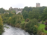
It eventually returns eastward near Hudswell before it flows past the main town of the valley, Richmond
. The river then starts a series of long south east meanders past Brompton-on-Swale and under the A1 at Catterick Bridge before turning south past Catterick. The river continues long south and south east meanders past Thrintoft and Morton-on-Swale. As it starts to pursue a more constant southerly flow it is joined by the River Wiske
before passing Skipton-on-Swale, Catton, Topcliffe and Asenby. It then flows past Helperby and Myton-On-Swale before joining the River Ure
.
, rowan
and bird cherry
along with shrubs such as hawthorn, hazel
and holly
. There are smaller populations of yew
and sycamore. Pine
, larch
and spruce
occur mostly in plantations with alder
and willow
common along the river banks. The many hay meadows are filled with buttercup and wood cranesbill.
, Permian
and Triassic
rock, all of which are atop a layer of Lower Paleozoic
beds. These rocks are rich in minerals and metalliferous sulfide ores such as Galena
, Sphalerite
, Chalcopyrite
and Bravoite. There are also deposits of Fluorite
, Barite
, Witherite
, Calcite
, Dolomite
and Barytocalcite
.
Along the valley sides can be seen the typical Dales geology of Yoredale beds, alternating strata of Limestone
and Gritstone
. Small seams of coal
, particularly around Tan Hill, have been found and worked. During the last Ice Age, the glacier that dominated the valley was responsible for broadening it and altering the course of the river around Keld and Round Howe. It was also responsible for cutting the Kisden Gorge. Retreat moraines lower in the river valley can be seen around Gunnerside and Grinton Bridge.
and Neolithic
Ages with the discovery of flint tools and arrowheads. Around Harkerside are some small stone circles that date to the Bronze Age
and some Iron Age
defensive earthworks. Evidence of lead mining has been traced back to Roman times with finds at the Hurst mine. This industry seemed to decline until after the Danish invasions of the area. During the major ecclesiastical building of the 12th and 13th centuries, lead became a valuable commoodity and mining once again increased in the valley. Evidence of the lead mining can still be seen from the remains of the 18th century practice of 'hushing
' that involved creating turf dams across gills that were then released to wash away topsoil to expose the ore veins.
Around the 8th century, the river valley was settled by Angles
who established themselves at Reeth, Stainton, Grinton Bridge and Fremington. Two hundred years later the upper valley was settled by Norsemen
. After the Norman invasion, the lands of the valley were given to Count Alan of Brittany who built the castle at Richmond between 1071 and 1091. It was built on a bluff overlooking the River Swale.
Tourism now plays a major role in the economy of the river valley. the Yorkshire Dales Cycle Way follows the valley between Fremington and Gunnerside. The Coast to Coast Walk
passes through Richmond to Reeth and is crossed at Keld by the Pennine Way
, which goes through the upper valley from Buttertubs Pass
to Muker.
River
A river is a natural watercourse, usually freshwater, flowing towards an ocean, a lake, a sea, or another river. In a few cases, a river simply flows into the ground or dries up completely before reaching another body of water. Small rivers may also be called by several other names, including...
in Yorkshire
Yorkshire
Yorkshire is a historic county of northern England and the largest in the United Kingdom. Because of its great size in comparison to other English counties, functions have been increasingly undertaken over time by its subdivisions, which have also been subject to periodic reform...
, England
England
England is a country that is part of the United Kingdom. It shares land borders with Scotland to the north and Wales to the west; the Irish Sea is to the north west, the Celtic Sea to the south west, with the North Sea to the east and the English Channel to the south separating it from continental...
and a major tributary of the River Ure
River Ure
The River Ure is a river in North Yorkshire, England, approximately long from its source to the point where it changes name to the River Ouse. It is the principal river of Wensleydale, which is the only one of the Dales now named after a village rather than its river...
, which itself becomes the River Ouse
River Ouse, Yorkshire
The River Ouse is a river in North Yorkshire, England. The river is formed from the River Ure at Cuddy Shaw Reach near Linton-on-Ouse, about 6 miles downstream of the confluence of the River Swale with the River Ure...
, emptying into the North Sea
North Sea
In the southwest, beyond the Straits of Dover, the North Sea becomes the English Channel connecting to the Atlantic Ocean. In the east, it connects to the Baltic Sea via the Skagerrak and Kattegat, narrow straits that separate Denmark from Norway and Sweden respectively...
via the Humber Estuary
Humber
The Humber is a large tidal estuary on the east coast of Northern England. It is formed at Trent Falls, Faxfleet, by the confluence of the tidal River Ouse and the tidal River Trent. From here to the North Sea, it forms part of the boundary between the East Riding of Yorkshire on the north bank...
.
The name Swale is from the Anglo-Saxon word Sualuae meaning rapid and liable to deluge. Annual rainfall figures of 1800mm p.a. in the headwaters and 1300mm p.a. in the lower waters over a drop of 148m in 32 km, gives proof to its name. The river gives its name to the valley through which it flows, namely Swaledale
Swaledale
Swaledale is one of the northernmost dales in the Yorkshire Dales National Park in northern England. It is the dale of the River Swale on the east side of the Pennines in North Yorkshire.-Geographical overview:...
.
The river and its valley are home to many types of flora and fauna typical to the Yorkshire Dales
Yorkshire Dales
The Yorkshire Dales is the name given to an upland area in Northern England.The area lies within the historic county boundaries of Yorkshire, though it spans the ceremonial counties of North Yorkshire, West Yorkshire and Cumbria...
. Like similar rivers in the region, the river carves through several types of rock and has features typical of both river and glacial erosion. The River Swale has been a contributory factor in the settlements that have been recorded throughout its history. It has provided water to aid in the raising of crops and livestock, but also in the various mining activities that have occurred since Roman times and before.
Course
The source of the River Swale is at the confluence of the Birkdale BeckBirkdale, North Yorkshire
Birkdale is a dale in the Yorkshire Dales National Park, in North Yorkshire, England. The dale itself is very small compared to some of the other Yorkshire dales. It has one small hamlet called Keld. The dale itself is a tributary dale to Swaledale, another dale in the Yorkshire Dales...
and the Great Sleddale Beck. The river flows north-north east past lead mines on its northern bank and the end of Whitsundale and then easterly towards the first of many waterfalls in the headwaters. After flowing over Wain Wath Force
Wain Wath Force
Wain Wath Force is a waterfall situated on the River Swale in the Yorkshire Dales National Park, North Yorkshire, England. The falls are located at grid reference , one kilometre upstream from the hamlet of Keld which has three other waterfalls in its vicinity, namely Kisdon Force, East Gill Force...
the river continues south east over Hoggarts Leap and Catrake Force
Catrake Force
Catrake Force is a waterfall on the river Swale in North Yorkshire, England. It is not visible from the road but only a short walk to reach it. It comprises a series of 4 steps each its own small waterfall and each with a very different character with the largest single drop being about .It lies on...
near Keld, before it reaches East Gill Force
East Gill Force
East Gill Force is a waterfalls in Swaledale, 300 metres to the east of the hamlet of Keld, in the Yorkshire Dales National Park, North Yorkshire, England. The falls are located on East Gill at grid reference , just before its confluence with the River Swale at the point where the Pennine Way and...
and Kisdon Force
Kisdon Force
Kisdon Force is a series of waterfalls on the River Swale in Swaledale, England. The falls are situated at grid reference within the Yorkshire Dales National Park in the county of North Yorkshire, 500 metres downstream from the small hamlet of Keld....
. Shortly after Swinner Gill joins the river it swings sharply south towards the village of Muker where Straw Beck joins and the river turns east again. The river flows past Gunnerside towards Feetham where it turns north east for a short while before returning east past Healuagh, Reeth and Grinton. The river then swings gently south east and east below Marrick before turning north eastward and then north past Marske.
It eventually returns eastward near Hudswell before it flows past the main town of the valley, Richmond
Richmond, North Yorkshire
Richmond is a market town and civil parish on the River Swale in North Yorkshire, England and is the administrative centre of the district of Richmondshire. It is situated on the edge of the Yorkshire Dales National Park, and serves as the Park's main tourist centre...
. The river then starts a series of long south east meanders past Brompton-on-Swale and under the A1 at Catterick Bridge before turning south past Catterick. The river continues long south and south east meanders past Thrintoft and Morton-on-Swale. As it starts to pursue a more constant southerly flow it is joined by the River Wiske
River Wiske
The River Wiske is a river in the county of Yorkshire, England and is a tributary of the River Swale. The Wiske gives its name to several of the villages it passes through. The name Wiske is derived from an Old English word wisca meaning a water meadow....
before passing Skipton-on-Swale, Catton, Topcliffe and Asenby. It then flows past Helperby and Myton-On-Swale before joining the River Ure
River Ure
The River Ure is a river in North Yorkshire, England, approximately long from its source to the point where it changes name to the River Ouse. It is the principal river of Wensleydale, which is the only one of the Dales now named after a village rather than its river...
.
River levels
| Monitoring Station | Station Elevation | Low water level | High water level | Record high level |
|---|---|---|---|---|
| Park Bridge | 325 m (1,066.3 ft) | 0 m (0 ft) | 2.5 m (8.2 ft) | 3.04 m (10 ft) |
| Grinton Bridge | 178 m (584 ft) | 0 m (0 ft) | 1.5 m (4.9 ft) | 2.51 m (8.2 ft) |
| Richmond Lownthwaite Bridge | 114 m (374 ft) | 0 m (0 ft) | 2 m (6.6 ft) | 4.19 m (13.7 ft) |
| Catterick Bridge | 60 m (196.9 ft) | 0.3 m (0.984251968503937 ft) | 2.4 m (7.9 ft) | 3.48 m (11.4 ft) |
| Morton-on-Swale | 27 m (88.6 ft) | 0.13 m (0.426509186351706 ft) | 5.8 m (19 ft) | 6.47 m (21.2 ft) |
| Crakehill | 16 m (52.5 ft) | 0.22 m (0.721784776902887 ft) | 3 m (9.8 ft) | 5.45 m (17.9 ft) |
| Myton-on-Swale | 12 m (39.4 ft) | 0.44 m (1.4 ft) | 3.44 m (11.3 ft) | 6.02 m (19.8 ft) |
- Low and High Water Levels are an average figure.
Natural history
The River Swale and its valley support a range of habitats including broadleaved, mixed and conifer woodland as well as hay meadows and grasslands. Limestone scar, bracken, scrub and heather moorland can also be found. Amongst the species of tree that can be found are ash, birchBirch
Birch is a tree or shrub of the genus Betula , in the family Betulaceae, closely related to the beech/oak family, Fagaceae. The Betula genus contains 30–60 known taxa...
, rowan
Rowan
The rowans or mountain-ashes are shrubs or small trees in genus Sorbus of family Rosaceae. They are native throughout the cool temperate regions of the Northern Hemisphere, with the highest species diversity in the mountains of western China and the Himalaya, where numerous apomictic microspecies...
and bird cherry
Bird cherry
The bird cherries are a subgenus of the genus Prunus, characterised by having deciduous leaves, flowers 12-30 together on slender racemes produced in late spring well after leaf emergence, and small, sour fruit usually only palatable to birds, hence the name...
along with shrubs such as hawthorn, hazel
Hazel
The hazels are a genus of deciduous trees and large shrubs native to the temperate northern hemisphere. The genus is usually placed in the birch family Betulaceae, though some botanists split the hazels into a separate family Corylaceae.They have simple, rounded leaves with double-serrate margins...
and holly
Holly
Ilex) is a genus of 400 to 600 species of flowering plants in the family Aquifoliaceae, and the only living genus in that family. The species are evergreen and deciduous trees, shrubs, and climbers from tropics to temperate zones world wide....
. There are smaller populations of yew
Taxus baccata
Taxus baccata is a conifer native to western, central and southern Europe, northwest Africa, northern Iran and southwest Asia. It is the tree originally known as yew, though with other related trees becoming known, it may be now known as the English yew, or European yew.-Description:It is a small-...
and sycamore. Pine
Pine
Pines are trees in the genus Pinus ,in the family Pinaceae. They make up the monotypic subfamily Pinoideae. There are about 115 species of pine, although different authorities accept between 105 and 125 species.-Etymology:...
, larch
Larch
Larches are conifers in the genus Larix, in the family Pinaceae. Growing from 15 to 50m tall, they are native to much of the cooler temperate northern hemisphere, on lowlands in the north and high on mountains further south...
and spruce
Spruce
A spruce is a tree of the genus Picea , a genus of about 35 species of coniferous evergreen trees in the Family Pinaceae, found in the northern temperate and boreal regions of the earth. Spruces are large trees, from tall when mature, and can be distinguished by their whorled branches and conical...
occur mostly in plantations with alder
Alder
Alder is the common name of a genus of flowering plants belonging to the birch family . The genus comprises about 30 species of monoecious trees and shrubs, few reaching large size, distributed throughout the North Temperate Zone and in the Americas along the Andes southwards to...
and willow
Willow
Willows, sallows, and osiers form the genus Salix, around 400 species of deciduous trees and shrubs, found primarily on moist soils in cold and temperate regions of the Northern Hemisphere...
common along the river banks. The many hay meadows are filled with buttercup and wood cranesbill.
Geology
There are three distinct geological areas in Upper and Mid Swaledale. the upper reaches of the river flow over CarboniferousCarboniferous
The Carboniferous is a geologic period and system that extends from the end of the Devonian Period, about 359.2 ± 2.5 Mya , to the beginning of the Permian Period, about 299.0 ± 0.8 Mya . The name is derived from the Latin word for coal, carbo. Carboniferous means "coal-bearing"...
, Permian
Permian
The PermianThe term "Permian" was introduced into geology in 1841 by Sir Sir R. I. Murchison, president of the Geological Society of London, who identified typical strata in extensive Russian explorations undertaken with Edouard de Verneuil; Murchison asserted in 1841 that he named his "Permian...
and Triassic
Triassic
The Triassic is a geologic period and system that extends from about 250 to 200 Mya . As the first period of the Mesozoic Era, the Triassic follows the Permian and is followed by the Jurassic. Both the start and end of the Triassic are marked by major extinction events...
rock, all of which are atop a layer of Lower Paleozoic
Paleozoic
The Paleozoic era is the earliest of three geologic eras of the Phanerozoic eon, spanning from roughly...
beds. These rocks are rich in minerals and metalliferous sulfide ores such as Galena
Galena
Galena is the natural mineral form of lead sulfide. It is the most important lead ore mineral.Galena is one of the most abundant and widely distributed sulfide minerals. It crystallizes in the cubic crystal system often showing octahedral forms...
, Sphalerite
Sphalerite
Sphalerite is a mineral that is the chief ore of zinc. It consists largely of zinc sulfide in crystalline form but almost always contains variable iron. When iron content is high it is an opaque black variety, marmatite. It is usually found in association with galena, pyrite, and other sulfides...
, Chalcopyrite
Chalcopyrite
Chalcopyrite is a copper iron sulfide mineral that crystallizes in the tetragonal system. It has the chemical composition CuFeS2. It has a brassy to golden yellow color and a hardness of 3.5 to 4 on the Mohs scale. Its streak is diagnostic as green tinged black.On exposure to air, chalcopyrite...
and Bravoite. There are also deposits of Fluorite
Fluorite
Fluorite is a halide mineral composed of calcium fluoride, CaF2. It is an isometric mineral with a cubic habit, though octahedral and more complex isometric forms are not uncommon...
, Barite
Barite
Baryte, or barite, is a mineral consisting of barium sulfate. The baryte group consists of baryte, celestine, anglesite and anhydrite. Baryte itself is generally white or colorless, and is the main source of barium...
, Witherite
Witherite
Witherite is a barium carbonate mineral, BaCO3, in the aragonite group. Witherite crystallizes in the orthorhombic system and virtually always is twinned. The mineral is colorless, milky white, grey, pale yellow, green, to pale brown. The specific gravity is 4.3, which is high for a translucent...
, Calcite
Calcite
Calcite is a carbonate mineral and the most stable polymorph of calcium carbonate . The other polymorphs are the minerals aragonite and vaterite. Aragonite will change to calcite at 380-470°C, and vaterite is even less stable.-Properties:...
, Dolomite
Dolomite
Dolomite is a carbonate mineral composed of calcium magnesium carbonate CaMg2. The term is also used to describe the sedimentary carbonate rock dolostone....
and Barytocalcite
Barytocalcite
Barytocalcite is a barium calcium carbonate mineral with the chemical formula BaCa2. It crystallizes in the monoclinic crystal system typically as massive to druzy accumulations of transparent white to yellow to grey aggregates of slender prismatic crystals...
.
Along the valley sides can be seen the typical Dales geology of Yoredale beds, alternating strata of Limestone
Limestone
Limestone is a sedimentary rock composed largely of the minerals calcite and aragonite, which are different crystal forms of calcium carbonate . Many limestones are composed from skeletal fragments of marine organisms such as coral or foraminifera....
and Gritstone
Gritstone
Gritstone or Grit is a hard, coarse-grained, siliceous sandstone. This term is especially applied to such sandstones that are quarried for building material. British gritstone was used for millstones to mill flour, to grind wood into pulp for paper and for grindstones to sharpen blades. "Grit" is...
. Small seams of coal
Coal
Coal is a combustible black or brownish-black sedimentary rock usually occurring in rock strata in layers or veins called coal beds or coal seams. The harder forms, such as anthracite coal, can be regarded as metamorphic rock because of later exposure to elevated temperature and pressure...
, particularly around Tan Hill, have been found and worked. During the last Ice Age, the glacier that dominated the valley was responsible for broadening it and altering the course of the river around Keld and Round Howe. It was also responsible for cutting the Kisden Gorge. Retreat moraines lower in the river valley can be seen around Gunnerside and Grinton Bridge.
History
The earliest evidence of occupation in the river valley can be dated to the MesolithicMesolithic
The Mesolithic is an archaeological concept used to refer to certain groups of archaeological cultures defined as falling between the Paleolithic and the Neolithic....
and Neolithic
Neolithic
The Neolithic Age, Era, or Period, or New Stone Age, was a period in the development of human technology, beginning about 9500 BC in some parts of the Middle East, and later in other parts of the world. It is traditionally considered as the last part of the Stone Age...
Ages with the discovery of flint tools and arrowheads. Around Harkerside are some small stone circles that date to the Bronze Age
Bronze Age
The Bronze Age is a period characterized by the use of copper and its alloy bronze as the chief hard materials in the manufacture of some implements and weapons. Chronologically, it stands between the Stone Age and Iron Age...
and some Iron Age
Iron Age
The Iron Age is the archaeological period generally occurring after the Bronze Age, marked by the prevalent use of iron. The early period of the age is characterized by the widespread use of iron or steel. The adoption of such material coincided with other changes in society, including differing...
defensive earthworks. Evidence of lead mining has been traced back to Roman times with finds at the Hurst mine. This industry seemed to decline until after the Danish invasions of the area. During the major ecclesiastical building of the 12th and 13th centuries, lead became a valuable commoodity and mining once again increased in the valley. Evidence of the lead mining can still be seen from the remains of the 18th century practice of 'hushing
Hushing
Hushing is an ancient and historic mining method using a flood or torrent of water to reveal mineral veins. The method was applied in several ways, both in prospecting for ores, and for their exploitation. Mineral veins are often hidden below soil and sub-soil, which must be stripped away to...
' that involved creating turf dams across gills that were then released to wash away topsoil to expose the ore veins.
Around the 8th century, the river valley was settled by Angles
Angles
The Angles is a modern English term for a Germanic people who took their name from the ancestral cultural region of Angeln, a district located in Schleswig-Holstein, Germany...
who established themselves at Reeth, Stainton, Grinton Bridge and Fremington. Two hundred years later the upper valley was settled by Norsemen
Norsemen
Norsemen is used to refer to the group of people as a whole who spoke what is now called the Old Norse language belonging to the North Germanic branch of Indo-European languages, especially Norwegian, Icelandic, Faroese, Swedish and Danish in their earlier forms.The meaning of Norseman was "people...
. After the Norman invasion, the lands of the valley were given to Count Alan of Brittany who built the castle at Richmond between 1071 and 1091. It was built on a bluff overlooking the River Swale.
Economy
Over the centuries, lead mining and cattle farming have been the main industries, but competition from the rest of the world saw them decline by the end of the 19th century. Some crop farming also took place, most notably during the warm periods of the 13th century.Tourism now plays a major role in the economy of the river valley. the Yorkshire Dales Cycle Way follows the valley between Fremington and Gunnerside. The Coast to Coast Walk
Coast to Coast Walk
The Coast to Coast Walk is a 192-mile unofficial and mostly unsignposted long distance footpath in Northern England...
passes through Richmond to Reeth and is crossed at Keld by the Pennine Way
Pennine Way
The Pennine Way is a National Trail in England. The trail runs from Edale, in the northern Derbyshire Peak District, north through the Yorkshire Dales and the Northumberland National Park and ends at Kirk Yetholm, just inside the Scottish border. The path runs along the Pennine hills, sometimes...
, which goes through the upper valley from Buttertubs Pass
Buttertubs Pass
The Buttertubs Pass is a high road in the Yorkshire Dales, England. The road winds its way north from Simonstone near Hawes towards Thwaite and Muker past 20 metre deep limestone potholes called the Buttertubs, It is said that the name of the potholes came from the times when farmers would rest...
to Muker.
Gallery
Lists
| Settlements | Location | Tributaries | Confluence | Crossings | Location |
|---|---|---|---|---|---|
| Keld Keld, North Yorkshire Keld is a hamlet in the English county of North Yorkshire. It is situated on Swaledale, in the Yorkshire Dales. The name derives from the Viking word Kelda meaning a spring, and the village was once called Appletre Kelde - the spring near the apple trees.Keld is the crossing point of the Coast to... |
54.405°N 2.168°W | Holme Ash Gill | |54°24′11.37"N 2°13′6.08"W | High Bridge (B6270) | 54°24′26.87"N 2°12′1.64"W |
| Muker Muker Muker is a village and civil parish in the Richmondshire district of North Yorkshire, England. Situated in Swaledale, one of the Yorkshire Dales, its name... |
54.38378°N 2.14673°W | Little Ash Gill | 54°24′20.38"N 2°12′32.63"W | Low Bridge | 54°24′33.78"N 2°11′23.97"W |
| Gunnerside Gunnerside Gunnerside is a village in Swaledale, North Yorkshire, England, situated between the River Swale and its tributary, Gunnerside Beck.Gunnerside Ghyll , a smaller valley running northwards, at right angles to the Swale valley , was the site of a major lead mining industry in Swaledale until the late... |
54.379°N 2.076°W | Great Ash Gill | 54°24′26.33"N 2°12′6.83"W | Park Bridge | 54°24′31.32"N 2°10′38.17"W |
| Low Row Low Row Low Row is a village in Swaledale, in the Yorkshire Dales, North Yorkshire, England. It lies about 3 miles west of Reeth and is between Healaugh and Gunnerside. It is part of the Richmondshire parish Melbecks... |
54.37593°N 2.03088°W | Whitsunudale Beck | 54°24′27.99"N 2°11′50.00"W | Ivelet Bridge | 54°22′32.50"N 2°6′16.39"W |
| Reeth Reeth Reeth is a village in the Yorkshire Dales within the Richmondshire district of North Yorkshire, England and principal settlement of Swaledale. It is situated at the meeting point of the two most northerly of the Yorkshire Dales: Swaledale and Arkengarthdale.... |
54.3876°N 1.9422°W | Blackburn Beck | 54°24′33.11"N 2°10′48.27"W | Gunnerside Great Brsige (B6270) | 54°22′32.31"N 2° 4′43.47"W |
| Grinton Grinton Grinton is a small village and civil parish in the Yorkshire Dales, in the Richmondshire district of North Yorkshire, England. Close to Reeth and Fremington, it lies 11 miles west of Richmond on the B6270 road.-St Andrew's church:... |
54.38094°N 1.92974°W | Stonesdale Beck | 54°24′31.73"N 2°10′28.76"W | Isles Bridge | 54°22′22.13"N 2° 2′11.46"W |
| Richmond Richmond, North Yorkshire Richmond is a market town and civil parish on the River Swale in North Yorkshire, England and is the administrative centre of the district of Richmondshire. It is situated on the edge of the Yorkshire Dales National Park, and serves as the Park's main tourist centre... |
54.4035°N 1.7373°W | Oldfield Gutter | 54°24′5.88"N 2° 9′6.11"W | Scabba Wath Bridge | 54°22′49.35"N 1°59′31.68"W |
| Brompton-on-Swale Brompton-on-Swale Brompton-on-Swale is a village and civil parish in the Richmondshire district of North Yorkshire, England. The village is located three miles east of Richmond. Its name comes from the fact that the River Swale is very close to the town... |
54.3917°N 1.6619°W | Swinner Gill | 54°23′56.07"N 2° 8′36.93"W | Grinton Bridge (B6270) | 54°22′55.86"N 1°55′47.78"W |
| Catterick Bridge Catterick Bridge Catterick Bridge is a hamlet about 1 mile north of Catterick Village in North Yorkshire, England. It is home to Catterick Bridge Racecourse, a pub and a few houses... |
54.38864°N 1.65047°W | West Arn Gill | 54°23′44.50"N 2° 8′25.28"W | Downholme Bridge | 54°23′16.77"N 1°49′36.49"W |
| Catterick Catterick, North Yorkshire Catterick , sometimes Catterick Village, to distinguish it from the nearby Catterick Garrison, is a village and civil parish in the Richmondshire district of North Yorkshire, England... |
54.372°N 1.623°W | Straw Beck | 54°22′35.40"N 2° 8′3.83"W | Lownethwaite Bridge (A6108) | 54°24′5.29"N 1°46′34.13"W |
| Great Langton Great Langton Great Langton is a small village and civil parish in the district of Hambleton, North Yorkshire, England. The village lies on the B6271 road, between Scorton and Northallerton, on the northern bank of the River Swale and it was once known as Langton-upon-Swale.... |
54.362630°N 1.547290°W | Routin Gill | 54°22′29.20"N 2° 7′25.83"W | Bridge Street, Richmond | 54°24′1.96"N 1°44′25.15"W |
| Little Fencote Little Fencote Little Fencote is a small village in the Hambleton district of North Yorkshire, England, near Fencote and Kirkby Fleetham about east of the A1 road.... |
54.332692°N 1.567842°W | Oxnop Gill | 54°22′32.11"N 2° 6′17.05"W | Station Road, Richmond (A6136) | 54°24′14.23"N 1°43′50.77"W |
| Morton-on-Swale Morton-on-Swale Morton-on-Swale is a large village and civil parish in the Hambleton district of North Yorkshire, England. It lies on the A684 road about 4 miles west of Northallerton. It is very close to the village of Ainderby Steeple... |
54.32181°N 1.50314°W | Shore Gill | 54°22′34.86"N 2° 5′56.92"W | A1 road (Great Britain) | 54°23′17.81"N 1°39′21.14"W |
| Bedale Bedale Bedale is a market town and civil parish in the district of Hambleton, North Yorkshire, England. It lies north of Leeds, southwest of Middlesbrough, and south west of the county town of Northallerton... |
54.2833°N 1.5833°W | Gunnerside Gill | 54°22′32.05"N 2° 4′42.41"W | Catterick Bridge (A6138) | 54°23′21.44"N 1°39′5.25"W |
| Gatenby Gatenby Gatenby is a secluded village and civil parish in the Hambleton district of North Yorkshire, England. It is situated about two miles east of the A1 road, near to the River Swale... |
54.28515°N 1.50112°W | Haverdale Beck | 54°22′20.68"N 2° 2′15.51"W | Stoney Leigh Bridge | 54°21′46.06"N 1°33′15.41"W |
| Maunby Maunby Maunby is a village and civil parish in the Hambleton district of North Yorkshire, England, about six miles south of Northallerton and on the River Swale.... |
54°16′N 1°27′W | Mirk gill | 54°22′18.48"N 2° 1′46.33"W | Swale Bridge (Wensleydale Railway) | 54°19′24.12"N 1°30′38.12"W |
| Pickhill Pickhill Pickhill is a village in the Hambleton district of North Yorkshire, England. Located a mile east of the A1, it neighbours Sinderby, Holme and Ainderby Quernhow.Pickhill is most noted for its primary school,... |
54.24705°N 1.47007°W | Birks Gill | 54°22′19.31"N 2° 1′44.01"W | Morton Bridge (A684) | 54°19′14.45"N 1°30′41.00"W |
| Skipton-on-Swale Skipton-on-Swale Skipton-on-Swale is a small village and civil parish in the Hambleton district of North Yorkshire, England. It lies on the A61 road, about 4 miles west of Thirsk.... |
54.212650°N 1.440185°W | Scabba Wath | 54°22′50.16"N 1°59′15.05"W | Skipton Bridge (A61) | 54°12′45.38"N 1°26′37.19"W |
| Catton Catton, North Yorkshire Catton is a village and civil parish in the Hambleton district of North Yorkshire, England. It is situated between Thirsk and Ripon, on the River Swale.... |
54.197°N 1.434°W | Barney Beck | 54°22′53.87"N 1°58′37.77"W | Topcliffe Bridge (A167) | 54°10′40.53"N 1°23′29.71"W |
| Baldersby St James Baldersby St James Baldersby St James is a village in the Harrogate district of North Yorkshire, England.... |
54.18687°N 1.44201°W | Arkle Beck | 54°22′55.33"N 1°56′4.60"W | A168 | 54°10′27.26"N 1°23′3.83"W |
| Topcliffe Topcliffe, North Yorkshire Topcliffe is a village and civil parish in the Hambleton district of North Yorkshire, England. The village is situated on the River Swale, close to the A168 and about five miles south-west of Thirsk... |
54.1784°N 1.3863°W | Cogden Beck | 54°22′46.47"N 1°54′45.42"W | Thornton Bridge | 54° 8′12.15"N 1°20′19.75"W |
| Cundall" | 54.14785°N 1.35248°W | Hags Gill | 54°22′25.15"N 1°53′54.76"W | Myton Bridge | 54° 5′41.16"N 1°20′5.23"W |
| Fawdington Fawdington Fawdington is a village and civil parish in the Hambleton district of North Yorkshire, England. It is on the River Swale and near the A1 road, eight miles south of Thirsk.... |
54.14907°N 1.33099°W | Gill Beck | 54°22′32.83"N 1°51′18.93"W | ||
| Brafferton Brafferton, North Yorkshire Brafferton is a village and civil parish in the Hambleton district of North Yorkshire, England. According to the 2001 census it had a population of 257.The village is situated about ten miles south of Thirsk, on the River Swale.... |
54.126137°N 1.327460°W | Oxque Beck | 54°23′4.36"N 1°50′23.91"W | ||
| Helperby Helperby Helperby is a village and civil parish in the Hambleton district of North Yorkshire, England, about five miles west of Easingwold. Over the years it has joined on to Brafferton.... |
54.122200°N 1.328400°W | Marske Beck | 54°23′46.83"N 1°49′42.70"W | ||
| Myton-on-Swale Myton-on-Swale Myton-on-Swale is a village and civil parish in the Hambleton district of North Yorkshire, England. It is about east of Boroughbridge and on the River Swale.- History :... |
54.094°N 1.331°W | Clapgate Beck | 54°24′17.93"N 1°49′20.56"W | ||
| Sand Beck | 54°23′53.03"N 1°43′8.34"W | ||||
| Colburn Beck | 54°23′31.10"N 1°41′9.56"W | ||||
| Skeeby Beck | 54°23′36.73"N 1°40′27.51"W | ||||
| Brough Beck | 54°22′15.05"N 1°36′38.62"W | ||||
| Fiddale Beck | 54°21′52.02"N 1°33′55.71"W | ||||
| Kiplin Beck | 54°21′49.43"N 1°33′21.67"W | ||||
| The Stell | 54°21′28.32"N 1°32′15.85"W | ||||
| Mill Beck | 54°20′14.50"N 1°31′47.21"W | ||||
| Bedale Beck | 54°18′15.21"N 1°30′50.03"W | ||||
| River Wiske River Wiske The River Wiske is a river in the county of Yorkshire, England and is a tributary of the River Swale. The Wiske gives its name to several of the villages it passes through. The name Wiske is derived from an Old English word wisca meaning a water meadow.... |
54°14′38.19"N 1°26′19.94"W | ||||
| Cod Beck | 54°10′3.88"N 1°21′58.63"W | ||||
| Crakehill Beck | 54° 9′7.14"N 1°20′22.01"W | ||||
| Cundall Beck | 54° 8′13.20"N 1°20′18.10"W |