
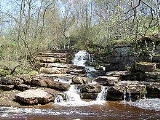
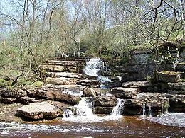
East Gill Force
Encyclopedia
Swaledale
Swaledale is one of the northernmost dales in the Yorkshire Dales National Park in northern England. It is the dale of the River Swale on the east side of the Pennines in North Yorkshire.-Geographical overview:...
, 300 metres to the east of the hamlet of Keld
Keld, North Yorkshire
Keld is a hamlet in the English county of North Yorkshire. It is situated on Swaledale, in the Yorkshire Dales. The name derives from the Viking word Kelda meaning a spring, and the village was once called Appletre Kelde - the spring near the apple trees.Keld is the crossing point of the Coast to...
, in the Yorkshire Dales National Park
Yorkshire Dales
The Yorkshire Dales is the name given to an upland area in Northern England.The area lies within the historic county boundaries of Yorkshire, though it spans the ceremonial counties of North Yorkshire, West Yorkshire and Cumbria...
, North Yorkshire
North Yorkshire
North Yorkshire is a non-metropolitan or shire county located in the Yorkshire and the Humber region of England, and a ceremonial county primarily in that region but partly in North East England. Created in 1974 by the Local Government Act 1972 it covers an area of , making it the largest...
, England
England
England is a country that is part of the United Kingdom. It shares land borders with Scotland to the north and Wales to the west; the Irish Sea is to the north west, the Celtic Sea to the south west, with the North Sea to the east and the English Channel to the south separating it from continental...
. The falls are located on East Gill at grid reference , just before its confluence with the River Swale
River Swale
The River Swale is a river in Yorkshire, England and a major tributary of the River Ure, which itself becomes the River Ouse, emptying into the North Sea via the Humber Estuary....
at the point where the Pennine Way
Pennine Way
The Pennine Way is a National Trail in England. The trail runs from Edale, in the northern Derbyshire Peak District, north through the Yorkshire Dales and the Northumberland National Park and ends at Kirk Yetholm, just inside the Scottish border. The path runs along the Pennine hills, sometimes...
and the Coast to Coast Walk
Coast to Coast Walk
The Coast to Coast Walk is a 192-mile unofficial and mostly unsignposted long distance footpath in Northern England...
intersect. The falls are a popular spot for visitors, not just long distance walkers but also families and picnickers because of the close proximity of the road. East Gill Force has two main torrents: the upper falls have an impressive 4.5 metre drop while the lower section is a series of stepped cascades that fall three metres as East Gill enters the River Swale.
East Gill Force is one of four waterfalls in the Keld area, the others being Kisdon Force
Kisdon Force
Kisdon Force is a series of waterfalls on the River Swale in Swaledale, England. The falls are situated at grid reference within the Yorkshire Dales National Park in the county of North Yorkshire, 500 metres downstream from the small hamlet of Keld....
, Catrake Force
Catrake Force
Catrake Force is a waterfall on the river Swale in North Yorkshire, England. It is not visible from the road but only a short walk to reach it. It comprises a series of 4 steps each its own small waterfall and each with a very different character with the largest single drop being about .It lies on...
and Wain Wath Force
Wain Wath Force
Wain Wath Force is a waterfall situated on the River Swale in the Yorkshire Dales National Park, North Yorkshire, England. The falls are located at grid reference , one kilometre upstream from the hamlet of Keld which has three other waterfalls in its vicinity, namely Kisdon Force, East Gill Force...
and occur where the river cuts a gorge through the carboniferous limestone
Carboniferous limestone
Carboniferous Limestone is a term used to describe a variety of different types of limestone occurring widely across Great Britain and Ireland which were deposited during the Dinantian epoch of the Carboniferous period. They were formed between 363 and 325 million years ago...
between the hills of Kisdon
Kisdon
Kisdon, also called Kisdon Hill is a fell situated in upper Swaledale in the Yorkshire Dales National Park in North Yorkshire, England.- Geography and history :...
and Rogan's Seat
Rogan's Seat
Rogan's Seat is a remote hill located near East Stonesdale and Gunnerside Gill, in the Yorkshire Dales in England.It is a high expanse of moorland that stretches alongside Swaledale, Swinner Gill and Gunnerside Gill...
. The falls in this area are called “forces” after the Norse word “Foss” which means waterfall. The falls are surrounded by deciduous broad leaved woodland.