
River Ure
Encyclopedia
The River Ure is a river in North Yorkshire
, England
, approximately 74 miles (119.1 km) long from its source to the point where it changes name to the River Ouse
. It is the principal river of Wensleydale
, which is the only one of the Dales
now named after a village rather than its river. The old name for the valley was Yoredale after the river that runs through it.
The Ure is one of many rivers and waterways that drain the Dales into the River Ouse
. Tributaries of the Ure include the River Swale
and the River Skell.
The earliest recorded name is Earp, but by 1142 it is recorded as Jor, hence Jervaulx (Jorvale) Abbey
. In 1530 it is recorded as Yeure, and local placenames include Yorebridge and Yoreburgh, but in Tudor times the antiquarian
s John Leland and William Camden
called it by its current name. The Old Celtic word for Ure was 'Isara' which evolved into 'Isure', 'Isurium', 'Isis' and finally into the Anglo-Saxon 'Ouse', giving an explanation of the changing name of the river.
To the east of Boroughbridge, the Ure is joined by the River Swale
. About 6 miles (9.7 km) downstream of this confluence, at Cuddy Shaw Reach near Linton-on-Ouse
, the river changes its name to the River Ouse
.
Mid Wensleydale is made of Great Scar limestone under Yoredale beds that make up the valley sides which are marked with stepped limestone scars. The valley floor is made from glacial drift tails and moraine. The river here is broad and gently flowing in meanders in a stony channel. There are four tributary valleys that contribute to several waterfalls in this area.
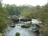
Lower Wensleydale is a broader version of mid Wensleydale with the river gently meandering until it drops significantly at Aysgarth over the platformed waterfalls. The valley sides become increasingly wooded.
From Middleham onwards the river is a typical mid-age river and meanders in wider arcs as it flows south east.
During medieval times, much of the upper dale was sheep country belonging to Middleham Castle
and Jervaulx Abbey.
In 1751, the Richmond to Lancaster turnpike was created and originally followed the Roman road from Bainbridge. In 1795 it was diverted along the valley to Hawes and took the Widdale route, now the B6255 to Ingleton.
More recently in 1990, Aysgarth Falls was used as a location in Robin Hood, Prince of Thieves
, in a the scene where Robin Hood fights Little John. It also featured in the 1992 film of Wuthering Heights
and the 1984 TV mini Series, A Woman of Substance
.
There are many waymarked footpaths and open countryside. The Pennine Way passes through Hawes.
There are large populations of badger, roe deer, fox and rabbit in the valley. Amongst the variety of birds that can be seen in the valley are golden plover, curlew and oystercatcher.
North Yorkshire
North Yorkshire is a non-metropolitan or shire county located in the Yorkshire and the Humber region of England, and a ceremonial county primarily in that region but partly in North East England. Created in 1974 by the Local Government Act 1972 it covers an area of , making it the largest...
, England
England
England is a country that is part of the United Kingdom. It shares land borders with Scotland to the north and Wales to the west; the Irish Sea is to the north west, the Celtic Sea to the south west, with the North Sea to the east and the English Channel to the south separating it from continental...
, approximately 74 miles (119.1 km) long from its source to the point where it changes name to the River Ouse
River Ouse, Yorkshire
The River Ouse is a river in North Yorkshire, England. The river is formed from the River Ure at Cuddy Shaw Reach near Linton-on-Ouse, about 6 miles downstream of the confluence of the River Swale with the River Ure...
. It is the principal river of Wensleydale
Wensleydale
Wensleydale is the valley of the River Ure on the east side of the Pennines in North Yorkshire, England.Wensleydale lies in the Yorkshire Dales National Park – one of only a few valleys in the Dales not currently named after its principal river , but the older name, "Yoredale", can still be seen...
, which is the only one of the Dales
Yorkshire Dales
The Yorkshire Dales is the name given to an upland area in Northern England.The area lies within the historic county boundaries of Yorkshire, though it spans the ceremonial counties of North Yorkshire, West Yorkshire and Cumbria...
now named after a village rather than its river. The old name for the valley was Yoredale after the river that runs through it.
The Ure is one of many rivers and waterways that drain the Dales into the River Ouse
River Ouse, Yorkshire
The River Ouse is a river in North Yorkshire, England. The river is formed from the River Ure at Cuddy Shaw Reach near Linton-on-Ouse, about 6 miles downstream of the confluence of the River Swale with the River Ure...
. Tributaries of the Ure include the River Swale
River Swale
The River Swale is a river in Yorkshire, England and a major tributary of the River Ure, which itself becomes the River Ouse, emptying into the North Sea via the Humber Estuary....
and the River Skell.
The earliest recorded name is Earp, but by 1142 it is recorded as Jor, hence Jervaulx (Jorvale) Abbey
Jervaulx Abbey
Jervaulx Abbey in East Witton near the city of Ripon, was one of the great Cistercian abbeys of Yorkshire, England, founded in 1156. Initially a Savigniac foundation, the abbey was later taken over by the Cistercian order and responsibility for it was taken by Byland Abbey. Originally founded in...
. In 1530 it is recorded as Yeure, and local placenames include Yorebridge and Yoreburgh, but in Tudor times the antiquarian
Antiquarian
An antiquarian or antiquary is an aficionado or student of antiquities or things of the past. More specifically, the term is used for those who study history with particular attention to ancient objects of art or science, archaeological and historic sites, or historic archives and manuscripts...
s John Leland and William Camden
William Camden
William Camden was an English antiquarian, historian, topographer, and officer of arms. He wrote the first chorographical survey of the islands of Great Britain and Ireland and the first detailed historical account of the reign of Elizabeth I of England.- Early years :Camden was born in London...
called it by its current name. The Old Celtic word for Ure was 'Isara' which evolved into 'Isure', 'Isurium', 'Isis' and finally into the Anglo-Saxon 'Ouse', giving an explanation of the changing name of the river.
Course
The source of the river is Ure Head on Abbotside Common where it flows west south-west to the valley floor and then turns south. Where it reaches the A684 it turns east along Wensleydale as far as Wensley. From here it flows south east to Jervaulx Abbey and shortly after south to Mickley. Here it returns east and then south to Ripon. A little way after Ripon it flows east again to Boroughbridge.To the east of Boroughbridge, the Ure is joined by the River Swale
River Swale
The River Swale is a river in Yorkshire, England and a major tributary of the River Ure, which itself becomes the River Ouse, emptying into the North Sea via the Humber Estuary....
. About 6 miles (9.7 km) downstream of this confluence, at Cuddy Shaw Reach near Linton-on-Ouse
Linton-on-Ouse
Linton-on-Ouse is a village and civil parish in the Hambleton district of North Yorkshire, England, about eight miles north-west of York.Since 1937 Linton-on-Ouse has been home to an airforce base, RAF Linton-on-Ouse. Since 1957 the main role of the base has been training pilots.-External links:*...
, the river changes its name to the River Ouse
River Ouse, Yorkshire
The River Ouse is a river in North Yorkshire, England. The river is formed from the River Ure at Cuddy Shaw Reach near Linton-on-Ouse, about 6 miles downstream of the confluence of the River Swale with the River Ure...
.
Water levels
| Monitoring Station | Station Elevation | Low water level | High water level | Record high level |
|---|---|---|---|---|
| Bainbridge | 208 m (682.4 ft) | 0.06 m (0.196850393700787 ft) | 2.5 m (8.2 ft) | 3.66 m (12 ft) |
| Kilgram | 94 m (308.4 ft) | 0.27 m (0.885826771653543 ft) | 1.5 m (4.9 ft) | 5.64 m (18.5 ft) |
| Masham | 76 m (249.3 ft) | 0.14 m (0.459317585301837 ft) | 2.3 m (7.5 ft) | 3.53 m (11.6 ft) |
| Ripon Ure Bank | 24 m (78.7 ft) | 0.03 m (0.0984251968503937 ft) | 0.89 m (2.9 ft) | 3.73 m (12.2 ft) |
| Westwick Lock | 22 m (72.2 ft) | 0.11 m (0.360892388451444 ft) | 2.5 m (8.2 ft) | 3.35 m (11 ft) |
| Boroughbridge | 15 m (49.2 ft) | 9.62 m (31.6 ft) | 13 m (42.7 ft) | 15.59 m (51.1 ft) |
- Low and High Water Levels are an average figure.
Geology
Upper Wensleydale is high, open and remote U shaped valley overlying Yoredale Beds. The gradient is gentle to the north end of the valley, becoming steeper further south. Drumlins lay either side of the river, which is shallow but fast flowing. The river is fed from many gills cutting through woodland and predominantly sheep farmsteads. The Settle to Carlisle railway runs along the western side of the valley here.Mid Wensleydale is made of Great Scar limestone under Yoredale beds that make up the valley sides which are marked with stepped limestone scars. The valley floor is made from glacial drift tails and moraine. The river here is broad and gently flowing in meanders in a stony channel. There are four tributary valleys that contribute to several waterfalls in this area.
Lower Wensleydale is a broader version of mid Wensleydale with the river gently meandering until it drops significantly at Aysgarth over the platformed waterfalls. The valley sides become increasingly wooded.
From Middleham onwards the river is a typical mid-age river and meanders in wider arcs as it flows south east.
History
The valley has been inhabited since prehistoric times. Examples of earthworks and other artefacts from the Bronze and Iron Ages can be seen in the Dales Countryside Museum in Hawes and the Romans built a fort at Bainbridge. Place-names in the valley denote the different types of settlers, such as Angles and Norse with typical suffixes like 'ton' and "sett".During medieval times, much of the upper dale was sheep country belonging to Middleham Castle
Middleham Castle
Middleham Castle in Wensleydale, in the county of North Yorkshire, was built by Robert Fitzrandolph, 3rd Lord of Middleham and Spennithorne, commencing in 1190. It was built near the site of an earlier motte and bailey castle...
and Jervaulx Abbey.
In 1751, the Richmond to Lancaster turnpike was created and originally followed the Roman road from Bainbridge. In 1795 it was diverted along the valley to Hawes and took the Widdale route, now the B6255 to Ingleton.
More recently in 1990, Aysgarth Falls was used as a location in Robin Hood, Prince of Thieves
Robin Hood: Prince of Thieves
Robin Hood: Prince of Thieves is a 1991 American adventure film directed by Kevin Reynolds. Kevin Costner heads the cast list as Robin Hood...
, in a the scene where Robin Hood fights Little John. It also featured in the 1992 film of Wuthering Heights
Emily Brontë's Wuthering Heights
Emily Brontë's Wuthering Heights was a 1992 feature film adaptation of Emily Brontë's novel Wuthering Heights directed by Peter Kosminsky....
and the 1984 TV mini Series, A Woman of Substance
A Woman of Substance (mini-series)
A Woman of Substance is a British/American television miniseries, produced in 1984. It is based on the 1979 book of the same name by the author Barbara Taylor Bradford.- Plot :In 1970, Emma Harte is a wealthy, formidable businesswoman...
.
Economy
Farming, lead mining, dairying and quarrying are the mainstays of the modern economy of the valley, along with tourism. The dairy at Hawes produces Wensleydale cheese. Brewing takes place in Masham at the Black Sheep and Theakston Breweries.There are many waymarked footpaths and open countryside. The Pennine Way passes through Hawes.
Natural History
The differing habitats of the area have their own populations of flora such as cranesbill, bistort, pignut and buttercup. Other varieties that can be seen in the area are wood anemones, violets, primroses, purple orchids, cowslips and herb paris. Some plants, such as spring sandwort, have managed to grow where the lead mining took placeThere are large populations of badger, roe deer, fox and rabbit in the valley. Amongst the variety of birds that can be seen in the valley are golden plover, curlew and oystercatcher.
Tributaries
From the source of the river:- Ure Head (Source)
- Fording Point
- Ure Crook
- Tongue Gill
- Grass Gill
- Scars Gill
- Fording Point
- Keld Gill
- Johnston Gill
- South Lunds Sike
- Ure Force
- Lunds Gill Thorn
- Tarn gill
- Scothole Gill
- Carr Gill
- Mossdale Beck
- Cottersdale Beck
- Widdale Beck
- Hardraw beck
- Thorne Sike
- Gayle Beck
- Blackburn Sike
- Eller Beck
- Nicholl Gill
- Raygill Sike
- Grays Beck
- River Bain
- Paddock Beck
- West Mawks Sike
- Newbiggin Beck
- Craike Sike Gutter
- Sister Ings Beck
- Starra Beck
- Wanley Beck
- Gill Beck
- Eller Beck
- Mill Race
- Low Beck
- Aysgarth Falls
- Bishopdale/Walden Becks
- Kendall Beck
- Belden Beck/Swan River
- Batt Island
- Mill Beck
- Wensley Beck
- Mill Beck
- Harmby/Spennithorne Becks
- The Batts
- River Cover
- Harker Beck
- Kilgram Bridge
- The Island
- Markfield Goit
- River Burn
- Black Robin Beck
- The Batts
- Mill Batts
- Light Water
- The Sike
- Hutton Mill Deep
- Ripon Canal
- Bishop Monkton Cutt
- Scour Gutter
- Ings Drain
- The Island
- Croft Drain
- Sleight
- River Swale
- Holbecks
- Beck Closes Drain
Settlements
From the source of the river:- Blades
- South Lunds
- AppersettAppersettAppersett is a hamlet in the Yorkshire Dales in the Richmondshire district of North Yorkshire, England only about a mile west of Hawes. It lies on the A684 road.-External links:* showing all 23 buildings with names...
- HawesHawesHawes is a small market town and civil parish in the Richmondshire district of North Yorkshire, England, being granted its market charter in 1699...
- BainbridgeBainbridge, North YorkshireBainbridge is a village and civil parish in the Richmondshire district of North Yorkshire, England. The village is situated in the Yorkshire Dales National Park, near the confluence of the River Bain with the River Ure. According to the 2001 census the population was 438.Bainbridge is served by a...
- WortonWorton, North YorkshireWorton is a hamlet in Wensleydale in the Yorkshire Dales in the Richmondshire district of North Yorkshire, England. It lies one mile east of Bainbridge on the A684 road and the River Ure, the biggest river in Wensleydale....
- Woodhall
- AysgarthAysgarthAysgarth is a village and civil parish in Wensleydale, in the Richmondshire district of North Yorkshire, England. The village is in the Yorkshire Dales National Park, about sixteen miles south-west from Richmond...
- Wensley
- Spennithorne
- MiddlehamMiddlehamMiddleham is a small market town and civil parish in the Richmondshire district of North Yorkshire, England. It lies in Wensleydale, in the Yorkshire Dales, on the north-facing side of the valley just above the junction of the River Ure and River Cover. There has been a settlement there since Roman...
- Ulshaw
- MashamMashamMasham is a small market town and civil parish in the Harrogate district of North Yorkshire, England. It has a population of 1,235. Situated in Wensleydale on the western bank of the River Ure, the name derives from the Anglo-Saxon "Mæssa's Ham", the homestead belonging to Mæssa. The Romans had...
- MickleyMickleyMickley is a small hamlet near Prudhoe and Stocksfield in the English county of Northumberland. It lies south of the river Tyne and is accessible via the A695. The neighbouring villages of Mickley Square and High Mickley are usually included under the general name of Mickley. This village once...
- West TanfieldWest TanfieldWest Tanfield is a village and civil parish in the Hambleton district of North Yorkshire, England. Situated about 6 miles north of Ripon on the A6108, which goes from Ripon into Wensleydale, West Tanfield is on the edge of both the Yorkshire Dales and the Vale of York...
- North Stainley
- NunwickNunwickNunwick is a village in the Harrogate district of North Yorkshire, England. It is about 1 mile north-east of Ripon....
- Hutton ConyersHutton ConyersHutton Conyers is a village and civil parish in the Harrogate district of North Yorkshire, England. It is situated near the River Ure and northeast of Ripon....
- RiponRiponRipon is a cathedral city, market town and successor parish in the Borough of Harrogate, North Yorkshire, England, located at the confluence of two streams of the River Ure in the form of the Laver and Skell. The city is noted for its main feature the Ripon Cathedral which is architecturally...
- RoecliffeRoecliffeRoecliffe is a village and civil parish in the Harrogate district of North Yorkshire, England. It is situated near the A1 road motorway and 1 mile west of Boroughbridge....
- BoroughbridgeBoroughbridgeBoroughbridge is a small town and civil parish in the Harrogate district of North Yorkshire, England. It is situated northwest of York. Until its bypass was built, it was on the main A1 road from London to Edinburgh...
- Lower Dunsforth
- AldwarkAldwark, North YorkshireAldwark is a village and civil parish in the Hambleton district of North Yorkshire, England. It has a population of 116 , and is situated on the River Ouse about 14 miles from York. It has a wood called Aldwark Wood and a wood called Aldwark Bridge Wood.The main attractions for visitors to the...
Crossings
From the source of the river:- Green Bridge (foot)
- How Beck Bridge
- Footbridge
- Blades Footbridge
- Unnamed road
- Unnamed road
- Thwaite Bridge
- A684
- Footbridge
- A684 New Bridge
- Footbridge
- Haylands Beck, Hawes
- Footbridge
- Yore Bridge, Bainbridge
- Worton Bridge, Worton
- Footbridge
- Footbridge
- Footbridge
- Yore Bridge
- A684 Wensley Bridge
- A684 Middleham Bridge
- Ulshaw Bridge
- Footbridge
- A6108 Masham Bridge
- Footbridge
- A6108 Tanfield Bridge
- North Bridge, Ripon
- A61 Ripon By-pass
- B6265 Hewick Bridge
- A1(M)
- A168 Arrows Bridge
- Borough Bridge
- Footbridge
- Aldwark Bridge (Toll)