
River Irwell
Encyclopedia
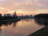
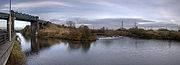
The River Irwell is a 39 miles (62.8 km) long river which flows through the Irwell Valley
in the counties of Lancashire
and Greater Manchester
in North West England
. The river's source
is at Irwell Springs on Deerplay Moor, approximately 1.5 miles (2.4 km) north of Bacup
, in the parish of Cliviger
, Lancashire. The Irwell flows through (and separates) the city centres of Manchester
and Salford, before joining the River Mersey
near Irlam
.
The lower reaches of the river were adapted for use as a trading route during the 17th and 18th centuries, and the stretch between Manchester and the River Mersey became part of the Mersey and Irwell Navigation. Large sections of the river west of Manchester were changed radically during the construction of the Manchester Ship Canal
, which opened in 1896, turning Manchester and Salford into a major sea port and leading to the development of Trafford Park
, which became the largest industrial estate in Europe. Changes were also made to prevent localised flooding throughout Manchester and Salford, particularly the rerouting of the river via the Anaconda Cut in Salford in 1970 and the River Irwell Flood Defence Scheme, completed in the early years of the 21st century.
The Irwell helped to facilitate the Industrial Revolution
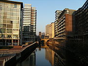
in North West England and, as a result, it became severely polluted with industrial waste and completely devoid of fish. Beginning in the latter half of the 20th century, a number of initiatives were implemented to remove the pollution, restock the river with fish and create a diverse environment for wildlife. Consequently, the stretches of the river which pass through Manchester and Salford now form the centrepiece of large-scale investment in business and residential developments and some areas, such as Salford Quays
, are now nationally important havens for wildlife. The Irwell is also host to a number of recreational activities, such as pleasure cruising, rowing
and fishing
and events such as the Northern Universities Boat Race.
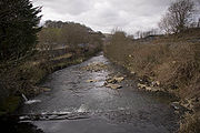
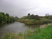
. Rising on the moors above Cliviger, the river flows south through Bacup
, Rawtenstall
, Ramsbottom
and Bury
before merging with the River Roch
near Radcliffe
. Turning west it is joined by the River Croal
near Farnworth
where it turns southeast through Kearsley
, Clifton
and Agecroft
, meander
ing around Lower Kersal
, Lower Broughton
and Salford and the centre of Manchester
, joining the rivers Irk
and Medlock
. Again turning west, from Salford, it meets the Mersey to the east of Irlam
, where the route was altered in the late 19th century to form part of the course of the Manchester Ship Canal
.
 Until the early 19th century the Irwell was well stocked with fish and other wildlife, and people living near Manchester Cathedral
used its water for drinking and other domestic purposes. During the Industrial Revolution
however, chemicals from local industries were discharged into the river in increasing amounts. The pollution proved fatal to wildlife; fish stocks had disappeared completely by about 1850. During the 20th century there was a slow improvement in water quality; the river was restocked with roach, bream and chub
, and sightings of brown trout
have become increasingly common.
Problems with water quality in some of the former Salford Docks basins became apparent with the redevelopment of the Salford Quays
area of the Manchester Ship Canal
. Years of runoff from sewers and roads had accumulated in the slow running waters of this area and decomposition of organic matter was causing oxygen depletion. In 2001 a compressed air injection system was introduced, which raised the oxygen levels in the water by up to 300%. The resulting improvement in water quality led to an increase of more than 30 in the number of invertebrate species such as freshwater shrimp. Spawning
and growth rates of fish species such as roach and perch
have increased to such an extent that they are now amongst the highest in England.
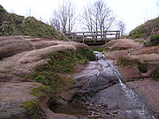
Two Sites of Special Scientific Interest (SSSIs) are located close to the banks of the Irwell, near to its confluence with the River Croal at Moses Gate Country Park
near Bolton
. The first is at Nob End
, a 21.7 acres (8.8 ha) site which has been designated because of its biological interest, based on the predominance of flora typical of limestone
grassland
including some nationally rare herbs and orchids. Nob End is also designated as a Local Nature Reserve
. The second site is Ashclough, which is a site of geological interest. These two SSSIs are among the 21 found in Greater Manchester. In Salford the river flows through Clifton Country Park
and Kersal Dale Country Park, both of which have been designated as Local Nature Reserve
s (LNRs).
Heron
s, cormorant
s, mute swan
s, kingfisher
s and many species of geese and ducks are regularly sighted on the river. The Manchester Ship Canal
near Salford Quays
is one of the top ten sites in Britain for diving ducks, providing a winter home to approximately 3,000 common pochard and 2,000 tufted duck
s.
The Irwell is all that remains of the shallow seas that covered most of south-east Lancashire in the Late Carboniferous period, when deposits of mud and sand were laid down. During the Permian
and Triassic
periods, red sandstone
s were deposited under arid, desert conditions and these became compressed into beds of shale
s, New Red Sandstone
and Manchester marl
s, alternating with layers of gritstone
. The glaciers of the Pleistocene
period radically re-shaped the landscape and then retreated, leaving behind deposits of sand, pebbles and boulder clay
that formed the fluvioglacial ridges
of the lower Irwell Valley
. Ashclough, a 14.3 acres (5.8 ha) site which comprises the steep banks of the river between Prestolee and Little Lever, has been designated an SSSI because of its geological interest, primarily because it is the best site in the area displaying the Ashclough marine band
and its associated strata. Ashclough is a site of national importance for interpreting the coal measure palaeogeography
of Great Britain.
extends from the moors above Bacup to the Manchester Ship Canal. The climate of the catchment area is wetter than the UK average, with rainfall of 1456 millimetres (57.3 in) per annum compared to 1231 millimetres (48.5 in) per annum, and the rivers quickly respond to rainfall. The topography varies considerably, with the upper reaches dominated by the Pennine
moors at an altitude of between 350 metres (1,148.3 ft) and 450 metres (1,476.4 ft) AOD
and the bottom of the catchment consisting of relatively flat land, which lies between 20 metres (65.6 ft) and 150 metres (492.1 ft) AOD. The watercourses are characterised by steep narrow valleys, which contributes to high rates of run-off, as does the underlying solid geology. This comprises Lower Coal Measures overlying Millstone Grit
, both of which are classified as minor aquifers
which will only hold relatively small amounts of water. The Millstone Grit is, in turn, underlain by limestone rocks from the lower Carboniferous period. The surface deposits comprise thick peat
in the upper reaches, with glacial boulder clay and glacial sand and gravel in the lower parts. The sand and gravel are also classified as a minor aquifer, whilst the boulder clay is a non-aquifer. The higher, steeper slopes of the upper part of the catchment provide a large source of erodible material and debris which is transported downstream to the lower, flatter parts of the catchment. Where the channel is constricted, this material is then deposited and can contribute to a reduction in channel capacity.
 The origins of the name "Irwell" are uncertain but many accept the Anglo-Saxon
origin, ere-well, meaning "hoar or white spring". Flint
scrapers
, knives and other materials associated with neolithic
man were discovered on Kersal Moor
in the late 19th century and early 20th century. There have been isolated finds of artefacts characteristic of this period along the Irwell valley, and a possible hunting site was excavated at Prestwich
Golf Course in 1982, which produced a quantity of Late Neolithic and Early Bronze Age
flints. Neolithic tools have also been found in the River Roch near Bury and in Radcliffe, and Bronze Age burial sites have been found in Bury and Shuttleworth
. The first recorded human settlements were those of the Celt
ic tribe, the Brigantes
, who farmed the uplands and lower reaches of the river in the late iron age
. In AD 79 the Roman Empire
conquered these tribes, building forts at the confluences of the Irwell and the rivers Irk and Medlock and naming the town Mamucium. They also built a ford with rectangular stone blocks at Cornbrook, which is thought to be the first man-made structure to span the river. For four hundred years the Pax Romana
brought peace, but their withdrawal in AD 410 left the tribes at the mercy of the Saxons
, who renamed the town Manigceastre. The Danes later seized, and all-but destroyed Manigceastre, and absorbed what was left of the tribes. The Danelaw
ruled until AD 920 when the Norsemen were expelled by Edward the Elder
.
In the Middle Ages
the town, which was now known as Manceastre (later to become Manchester
), grew and prospered, and trading vessels plied along the river. The hamlet of Kersal
, which now forms part of the City of Salford, was gifted to the Cluniac Priory of Lenton
, near Nottingham
, in 1142. The most important part of the gift was the fishing rights on the River Irwell, and even in the 18th century, the salmon rights on the rivers of Lancashire were let every year for many hundreds of pounds.
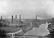
factories, mills and terraced hovels grew up along the river banks. Edward Corbett, the Borough Engineer of Salford, wrote in his 1907 book The River Irwell of his father's experiences around 1819, of seeing "large shoals of fish, chiefly gudgeon but also other fish, rising to the flies" from a vantage point on New Bailey bridge, (now Albert Bridge) in Manchester. Local industry dumped toxic chemicals into the river, such as gas-tar, gas-lime and ammonia water, and by 1850 fish stocks had all but disappeared. In 1860 the Irwell was described as "almost proverbial for the foulness of its waters; receiving the refuse of cotton factories, coal mines, print works, bleach works, dye works, chemical works, paper works, almost every kind of industry." In 1862 the Scottish
geologist
Hugh Miller
wrote about the Irwell, in his book First Impressions: The English People, describing it as:
 In the Victorian era
passenger boat trips were popular but cut-short by the foul smells from the river. In 1862 the Corporation of Salford promoted an Act of Parliament
enabling them to establish a River Conservancy Committee; they appointed a river inspector, and had to power to take action against anyone polluting the river. The Rivers Pollution Prevention Act 1876 was designed to solve the problems of river pollution, but it was largely ineffective. It did, however, lay the groundwork for the more draconian legislation which followed, and in 1891 the Mersey and Irwell Joint Committee was formed. Local authorities were ordered to provide sewage treatment
facilities, and industrial concerns were told to use the best practical means of preventing pollution. Salford was one of the first authorities in the Irwell watershed to install intercepting sewers and sewage treatment works at Mode Wheel Sewage works.
One of the most famous characters associated with the river during this time was Mark Addy
, who was born in a tenement
on The Parsonage near Blackfriars Bridge in Manchester
in 1838. Whenever anyone was in difficulty in the river, the cry would go up "Bring Mark Addy!" and he would race to the rescue. He was awarded a number of medals including the gold and silver medals from the Humane Society for the Hundred of Salford, and the Royal Humane Society
's bronze medal. In 1878 he became the only civilian ever to be awarded the Albert Medal (first class)
, His final rescue was on Whit Monday
in 1889, when he saved a young boy from a particularly sewage-laden section of the river. After this he became ill, and died of tuberculosis in 1890 aged 51. He had rescued over 50 people from the river during his lifetime.
 In 1939 the Mersey and Irwell Joint Committee was superseded by the Lancashire Rivers Board, but wartime conditions brought about further deterioration of the river. In 1951, the Rivers (Prevention of Pollution) Act was passed and this board disappeared to be replaced by the Mersey River Board, which was replaced in turn by the Mersey and Weaver River Authority in 1965.
In 1946, there was serious flooding in Salford, caused by a bottleneck at a bend in the river at Strangeways, on the border with Manchester. Flooding had been a problem for hundreds of years, and, in 1946, the decision was made to straighten and widen the river to increase its capacity. Work started in 1951 but it was not until September 1970 that water first flowed through the Anaconda Cut. The total cost of the project was £2m.
In a question to the House of Commons in 1950 the Member of Parliament
for Rossendale, Mr. Anthony Greenwood, highlighted the lamentable condition of the Irwell and one of its main tributaries, the River Roch
:
In 1951, it was announced that flood defence works were to be carried out on the stretch of the river passing through Lower Broughton between Cromwell Bridge and Gerald Road Bridge, although local property owners and shopkeepers were outraged at being asked to bear part of the cost. Work on the 8 feet (2.4 m) concrete wall did not get underway until June 1952 and was still only nearing completion when, in August 1957, nearby homes were threatened by flooding during heavy rain.
 A report in the Manchester Evening News
in 1971 stated that Bury Angling Society had signed an agreement with Bury Corporation giving them fishing rights along four miles (6 km) of the river between Summerseat and Radcliffe. The secretary of the society was quoted as saying:
The report went on to state that the society "intends to carry out stocking operations soon". In 1972 the newspaper reported that "tiddlers" (small fish) had been seen swimming in the "notorious inky Irwell" near Peel Park, Salford
. The Deputy chief water quality officer for Salford, Mr. Eric Harper, said:
Mr Harper went on to say that the Irwell had been well stocked with fish along its whole length 100 years ago but refused to guess when it would reach the same state again. In 1974 all of the river authorities were merged into the Regional Water Authorities. In the 1974 annual report of the North West Water Authority (NWWA)
, it was said that the river "once internationally famous, or infamous as the epitome of river pollution, is now in a much better state as compared with its condition at the time of a special survey carried out nine years ago." This was reported in an article in The Manchester Evening News on 26 October of that year which stated that:
calling it "quite revolting and horrible". A spokesperson for the NWWA said that, although the river had a reputation for being polluted, it was getting much better but still had not reached a state where they would be satisfied. She added that tests were being carried out to show the improved cleanliness of the Irwell and that 600 trout had recently been put in the river at Summerseat
, near Bury. The proposals were welcomed by both Salford University and Agecroft Rowing Club, with the university stating that they wished to use that section for their boat race. Later that year it was reported that hundreds of trees and shrubs were to be planted along the banks of the Irwell between Broughton and Pomona Dock in a £650,000 "green finger" scheme to "bring the countryside into the heart of industrial Salford". The dossier outlining the scheme, prepared by Salford's Technical Services Officer, emphasised the "bleak character" of the Irwell Valley with "many constructions by the river that are decaying and rotting" and said "the main problems are caused by an excess of ammonia and a high organic content from sewage effluents which discharge into the water upstream." The report recommended that "even more support should be given to the NWWA in their pollution control of the River Irwell."
Throughout the 1980s, sightings of fish as far downstream as Manchester city centre
were reported in local newspapers. In February 1981 the Manchester Evening News
reported that "ten jacksharps
, about two inches long" had been spotted by a site manager working on the Mark Addy public house
, which was then being built on the disused New Bailey Landing Stage, below New Bailey Street, on the border of Manchester and Salford. Plans for developing the river for recreational use were also coming to fruition as it was reported in 1982 that, over the May bank holiday
, the first pleasure cruise on the river in the 20th century would leave from the Mark Addy as part of a three-day experiment to see whether river cruises could be a success. In 1983 over 100 canal and river boats rode the flooded river for the Greater Manchester Waterways Festival, an event aimed at demonstrating how pleasure boating could "transform the bleak waterway in the heart of Manchester". By 1984 two local men felt the waters were clean enough for them to brave a ten mile (16 km) charity fund-raising swim from Clifton
to Manchester, although they were warned by a spokesman for the North West Water Authority that the cocktail of effluent and occasional untreated sewage meant that the Irwell was still "a class 4 river – top of the pollution chart". During 1985 the Croal–Irwell Valley local plan was launched, listing 187 proposals for the improvement of the valley and in 1986 the Mersey Basin Campaign was announced. The campaign was to cover a large area, from Rossendale
in the north to Crewe
in the south, and it was promised that £67m would be made available in the first three years for water- and land-based projects. In September 1987 plans were revealed for a mile-long landscaped walkway in Manchester city centre and developers announced plans to develop three bricked-up railway arches on the side of the river, opposite Manchester Cathedral
, into a wine bar and restaurant. In 1988 Manchester's first water bus made its maiden voyage from the New Bailey Landing Stage, then known as the Mark Addy Quay, on a five-mile (8 km) inaugural round trip to Salford Quays By the end of the 1980s ambitious plans had been announced to turn Manchester into a top international tourist centre "mainly based on the derelict areas around the waterways of Manchester, Salford and Trafford – the Irwell, the Irk, the ship canal and the Bridgewater Canal
...bringing £500m of investment and 13,000 new jobs over the next 10 years". The Manchester Ship Canal Company
also announced a £70 million redevelopment scheme for Pomona Docks
in Salford, to include a marina, homes, offices and other commercial developments.
 In 1990, the newly formed Mersey and Irwell Packet Company launched regular tourist trips along the river from a landing stage opposite the Granada Studios Tour
entrance in Quay Street, taking in the stretch from Castlefield to Salford Quays. This was not universally welcomed as, by September of that year, a retired chemical engineer claimed that the pleasure boat was "leaving clouds of methane in its wake as it disturbed sediment on the river bed". However, in 1991 a feature article appeared in the magazine Lancashire Life
extolling the virtues of the cruise, and stating that the Irwell "once thought a liability is in fact a major asset to urban regeneration ... now the twin cities compete to befriend her, to dress her in finery and proudly introduce her back into society. And the public are cordially invited back onto her waters." During 1994, construction work began on a new £1.3M footbridge to link Manchester and Salford, to be known as Trinity Bridge. The box-girder and steel cable construction was designed by Spanish architect Santiago Calatrava
to represent a ship in full sail as the centrepiece of the £50M Chapel Wharf Regeneration Scheme, which was expected to breathe new life into a run-down area of Salford and to create up to 8,000 new jobs. In May 1995 a new 30 miles (48.3 km) long multi-million pound arts trail, to be known as the Irwell Sculpture Trail
, was reported in the Manchester Evening News and in June 1997 work began on the £10M Lower Irwell Valley Flood Defence Scheme in Lower Kersal.
 In July 2000 there was a setback for the cleanup programme when a pollution incident affected approximately 2.5 miles (4 km) of the river between Rawtenstall
and Ramsbottom
, causing the death of more than 36,000 fish. The large number of fish killed, however, did serve to illustrate how much the river had improved from the lifeless, "melancholy stream" of the 1950s. In 2005 a £1M project to make the river "the cleanest it has been for decades" was announced by United Utilities
. The improvements included fitting filters on sewers in Lower Broughton to ensure litter was not washed into the river, as part of a scheme to improve overflows across Adlington
, Wigan
, Chorley
, Rochdale and Bury. Then in October 2008 United Utilities announced that work on the Ringley Fold Wastewater Works in Stoneclough, to be completed by the end of the year, should increase the number of fish in the river and "massively improve the environment locally so walkers, canoeists and anglers will all reap the benefits." The company said that this was to be the biggest scheme that they had undertaken in the region, and the project manager was quoted as saying:
The treatment plant, which was built in the 1930s and last updated in the 1970s, treats waste water from a population of half a million, from Bolton
, Prestwich
, Whitefield
and Clifton
.
There was another pollution incident in March 2008 when twenty miles of the river turned orange. Iron oxide
from old mine workings near the source at Irwell Springs had polluted the water since 1969 and in 1997 a Coal Authority survey identified the stretch as having the fourth worst case of minewater pollution in the country. A treatment plant was built in 1999 to remove the pollution at a cost of £1M; however, it is thought that there was a collapse in the mine after heavy rains in the spring of 2008. Although the water was stained with ochre
, no damage to wildlife was reported.
businessman Thomas Patten had made the River Mersey navigable as far as Warrington and suggested that there would be significant commercial value in extending this along the Irwell as far as Manchester. In 1721, Parliament
authorised the alteration with the Mersey and Irwell Navigation Act, and by 1736 work had been completed by creating eight canal locks along the 20 miles (32 km) route from Warrington to Manchester, allowing access to boats of up to 50 LT (51 t; 56 ST). The waterway, which became known as the Mersey & Irwell Navigation
, played a central role in the cotton
industry of the 18th century that spear-headed the Industrial Revolution.
built the Bridgewater Canal
, the task of crossing the Irwell was one of the main obstacles he faced. The solution was to build a canal-carrying bridge across the river, the first barge aqueduct
in England. The aqueduct, which opened in 1761, measured 12 metres (39 ft) high and 200 metres (656 ft) long, and became one of the wonders or the age. The Mersey and Irwell Navigation and the Bridgewater Canal competed for trade to and from Manchester for the next 120 years and specially designed barges with a shallow draft
, known as "Mersey flats
", were used on both waterways. Over the years both trade and rivalry continued to grow with each company offering reduced freight charges or special rates and concessions to gain business from the other. The most important cargo carried was raw cotton from Liverpool to Manchester but timber, dyewoods, pig iron
, lead, copper, nails, tar, sand, grain and flour were also carried. Passenger services had been operating on the Bridgewater Canal for some years and in 1807 the Irwell and Mersey Navigation Company began to compete with daily services between Runcorn
and Manchester
. In 1816 they began to use packet steamers. However, in 1830 the Liverpool and Manchester Railway
opened; packet boat
services went into decline, and ceased to operate completely in the 1860s. In Manchester two other canals used the Irwell as a point of access: the Manchester Bolton & Bury Canal from 1809, and the Manchester and Salford Junction Canal
from 1839. The previous year, the short Hulme Locks Branch Canal
had also connected the Irwell to the Bridgewater Canal at Castlefield. All are now non-navigable, although the first is under restoration.
 As the 19th century progressed, the increasing need for large freight carriers led to Liverpool
's dominance as a port. Manchester became increasingly reliant on its Merseyside
neighbour for its imports and exports, but the handling charges and dues charged by the Mersey Docks and Harbour Board made goods from Manchester uncompetitive. A solution was to build the Manchester Ship Canal. In 1887 the Bridgewater Navigation Company was purchased by the Manchester Ship Canal Company with a cheque for £1,710,000, which was at the time the largest cheque ever written, and the building of the Manchester Ship Canal began.
The canal, which was made by greatly deepening and widening the eastern section of the Mersey and Irwell Navigation, opened on 1 January 1894. It reduced the shipping costs of raw cotton to the mills and the dispatching the finished cloth overseas. By the mid-20th century, the UK cotton industry had gone into decline because of low-cost competition from Asian manufacturers. However, the canal had helped the region to become the centre of the Industrial Revolution, and it had transformed Manchester into England's third largest port, despite being 40 miles (64 km) inland. As the canal was built, it became clear that Brindley's famous aqueduct would have to be demolished, as it allowed insufficient headroom for the freighters that the canal would carry. Fortunately, in 1896 the councillors of Eccles paid to have the aqueduct moved to the spot it occupies today, alongside the canal. The Bridgewater Canal
is now carried over the Manchester Ship Canal by the equally celebrated Barton Swing Aqueduct
, which was completed in 1893 with the novel idea of "opening" by rotating 90 degrees to allow ships to pass.
The construction of the Manchester Ship Canal and the Salford Docks led to the development of Trafford Park
as the largest industrial estate in Europe, and brought employment to the area for the next eighty years. By the 1960s however, the UK had begun to lose its position as an industrial world power. The decline of heavy industry in the area, the increasing size of freight-carrying ships, and competition from road transport, brought about the decline of the terminal docks at Salford, which closed in 1982.
 The lower reaches of the Irwell have flooded many times in its history, the most well documented being the floods of 1866, 1946, 1954, 1980, and 2007. In December 1816 rapidly thawing snow
caused the river to flood, sweeping away a considerable amount of property including building materials and livestock. Locals reported the height of the river to have been almost as great as a more serious flood of 1768. A local public house, the Black Boy, suffered extensive damage as the water caused the rear wall to collapse, a local brewery was flooded with the loss of all its stock, and a Mersey Flat
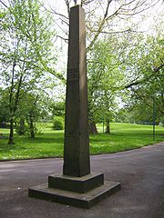
came free of its moorings, hitting Regent Bridge. In 1866, the "year of the great Flood", rain fell for three continuous days commencing on Tuesday 13 November. By the end of the first day, the river had risen 14 feet (4.3 m) above normal at Peel Park
, street lamps
could not be lit and mills were brought to a stop. In all, £1 million of property was damaged, 1100 acres (445.2 ha) of land was flooded, 700 people had to be rescued from wrecked homes, but only one man died by drowning. The height of the flood was marked by an obelisk
erected in Peel Park. The construction of the ship canal
is said to have reduced the risk of flooding, by providing a larger outlet below Regent bridge. In 1946 in Salford 5,300 properties were flooded, and 600 were flooded in 1954.
To alleviate such problems two flood storage basins with a capacity of 650000 cubic metres (850,167.9 cu yd) have been constructed to the west of Littleton Road, Kersal
, at a cost of around £11 million. As part of the River Irwell Flood Defence Scheme, the defences help to protect some 3,000 properties in Kersal and Lower Broughton against a 1 in 75 year flood. Concerns have been raised that a 1 in a 100 year flood would breach these defences and cause some £55 million damage to property. The defences proved successful on 22 January 2008, when the worst flooding to hit the region in thirty years caused the Irwell to burst its banks further downstream in the centre of Manchester.
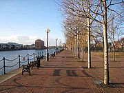 A large urban regeneration project, The Salford Quays
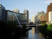
Development Plan, was published in 1985 and work began a few years later to redevelop the site for residential, business and leisure purposes. The Salford Quays waterside development has made living by the Irwell, and the Manchester Ship Canal into which it flows, fashionable once again.
There are further plans to "turn the tide on the years of neglect and once again embrace the River Irwell as a fundamental part of Manchester and Salford's heritage and future economic and social growth. The vision is to reinvent the central Manchester conurbation as the major waterfront destination in Northern England." A number of key stakeholders are involved in the development of this regeneration vision. These include Manchester, Salford and Trafford councils, Manchester Ship Canal Company, Environment Agency, Mersey Basin Campaign, local businesses, landowners, community groups and the wider Manchester, Salford and Trafford
communities.
, Salford City Council and Trafford Metropolitan Borough Council prepared planning guidance to support the delivery of a project for the restoration of the river and creation of a new urban park, to be called Irwell City Park. The intention is to develop 8 kilometres (5 mi) of riverside between The Meadows and Peel Park
in the north, through Salford and Manchester city centres, Ordsall
and Pomona Dock areas, around to Salford Quays
and Trafford Wharfside. The three authorities formally adopted the draft Planning Guidance in March 2008. The Guidance sets out the guidelines that the councils will use as a material consideration in determining applications for planning permission and other matters in the Irwell City Park area. It also establishes a set of principles to ensure the provision of a continuous riverside cycle/walkway, and the high quality design of new public open spaces and other infrastructure. An application is to be made to the North West Development Agency in October 2008 to support pre-project implementation work, including design and technical feasibility work.
Agecroft Rowing Club
was formed in 1861, making it one of the oldest open membership rowing clubs in the world. The club was originally based in the grounds of Agecroft Hall
and then a short distance downstream at Littleton Road. However, the river became impossible for eight's and fours to pass due to the encroachment of weeds and river life following the clean up of the environment. The club now operates from a boathouse next to the Salford Watersports Centre at Salford Quays
, which it has shared with the University of Salford
Boat Club since 2004. The boathouse, which the sport's governing body, the Amateur Rowing Association
, has nominated as the North West Centre of Excellence, also hosts the Two Cities Boat Race, which has been held on the river since 1972.
Irwell Valley
The Irwell Valley extends from the Forest of Rossendale in North West England, through to the cities of Salford and Manchester. The River Irwell runs through the valley, along with the River Croal.-Geology:...
in the counties of Lancashire
Lancashire
Lancashire is a non-metropolitan county of historic origin in the North West of England. It takes its name from the city of Lancaster, and is sometimes known as the County of Lancaster. Although Lancaster is still considered to be the county town, Lancashire County Council is based in Preston...
and Greater Manchester
Greater Manchester
Greater Manchester is a metropolitan county in North West England, with a population of 2.6 million. It encompasses one of the largest metropolitan areas in the United Kingdom and comprises ten metropolitan boroughs: Bolton, Bury, Oldham, Rochdale, Stockport, Tameside, Trafford, Wigan, and the...
in North West England
North West England
North West England, informally known as The North West, is one of the nine official regions of England.North West England had a 2006 estimated population of 6,853,201 the third most populated region after London and the South East...
. The river's source
Source (river or stream)
The source or headwaters of a river or stream is the place from which the water in the river or stream originates.-Definition:There is no universally agreed upon definition for determining a stream's source...
is at Irwell Springs on Deerplay Moor, approximately 1.5 miles (2.4 km) north of Bacup
Bacup
Bacup is a town within the Rossendale borough of Lancashire, England. It is located amongst the South Pennines, along Lancashire's eastern boundary with West Yorkshire. The town sits within a rural setting in the Forest of Rossendale, amongst the steep-sided upper-Irwell Valley, through which the...
, in the parish of Cliviger
Cliviger
Cliviger is a civil parish within the Borough of Burnley, in Lancashire, England. It is situated to the southeast of Burnley, and northwest of Todmorden and has a population of 2,350...
, Lancashire. The Irwell flows through (and separates) the city centres of Manchester
Manchester
Manchester is a city and metropolitan borough in Greater Manchester, England. According to the Office for National Statistics, the 2010 mid-year population estimate for Manchester was 498,800. Manchester lies within one of the UK's largest metropolitan areas, the metropolitan county of Greater...
and Salford, before joining the River Mersey
River Mersey
The River Mersey is a river in North West England. It is around long, stretching from Stockport, Greater Manchester, and ending at Liverpool Bay, Merseyside. For centuries, it formed part of the ancient county divide between Lancashire and Cheshire....
near Irlam
Irlam
Irlam is a suburban town and unparished area within the City of Salford in Greater Manchester, England. At the 2001 census it had a population of 18,504. The town lies on flat ground on the south side of the M62 motorway and the north bank of the Manchester Ship Canal, and is west-southwest of...
.
The lower reaches of the river were adapted for use as a trading route during the 17th and 18th centuries, and the stretch between Manchester and the River Mersey became part of the Mersey and Irwell Navigation. Large sections of the river west of Manchester were changed radically during the construction of the Manchester Ship Canal
Manchester Ship Canal
The Manchester Ship Canal is a river navigation 36 miles long in the North West of England. Starting at the Mersey Estuary near Liverpool, it generally follows the original routes of the rivers Mersey and Irwell through the historic counties of Cheshire and Lancashire. Several sets of locks lift...
, which opened in 1896, turning Manchester and Salford into a major sea port and leading to the development of Trafford Park
Trafford Park
Trafford Park is an area of the Metropolitan Borough of Trafford, in Greater Manchester, England. Located opposite Salford Quays, on the southern side of the Manchester Ship Canal, it is west-southwest of Manchester city centre, and north of Stretford. Until the late 19th century it was the...
, which became the largest industrial estate in Europe. Changes were also made to prevent localised flooding throughout Manchester and Salford, particularly the rerouting of the river via the Anaconda Cut in Salford in 1970 and the River Irwell Flood Defence Scheme, completed in the early years of the 21st century.
The Irwell helped to facilitate the Industrial Revolution
Industrial Revolution
The Industrial Revolution was a period from the 18th to the 19th century where major changes in agriculture, manufacturing, mining, transportation, and technology had a profound effect on the social, economic and cultural conditions of the times...
in North West England and, as a result, it became severely polluted with industrial waste and completely devoid of fish. Beginning in the latter half of the 20th century, a number of initiatives were implemented to remove the pollution, restock the river with fish and create a diverse environment for wildlife. Consequently, the stretches of the river which pass through Manchester and Salford now form the centrepiece of large-scale investment in business and residential developments and some areas, such as Salford Quays
Salford Quays
Salford Quays is an area of Salford in Greater Manchester, England, near the end of the Manchester Ship Canal. Previously the site of Manchester Docks, it became one of the first and largest urban regeneration projects in the United Kingdom following the closure of the dockyards in...
, are now nationally important havens for wildlife. The Irwell is also host to a number of recreational activities, such as pleasure cruising, rowing
Rowing (sport)
Rowing is a sport in which athletes race against each other on rivers, on lakes or on the ocean, depending upon the type of race and the discipline. The boats are propelled by the reaction forces on the oar blades as they are pushed against the water...
and fishing
Recreational fishing
Recreational fishing, also called sport fishing, is fishing for pleasure or competition. It can be contrasted with commercial fishing, which is fishing for profit, or subsistence fishing, which is fishing for survival....
and events such as the Northern Universities Boat Race.
Course
The Irwell is about 39 miles (62.8 km) in length, from its source to the confluence with the River MerseyRiver Mersey
The River Mersey is a river in North West England. It is around long, stretching from Stockport, Greater Manchester, and ending at Liverpool Bay, Merseyside. For centuries, it formed part of the ancient county divide between Lancashire and Cheshire....
. Rising on the moors above Cliviger, the river flows south through Bacup
Bacup
Bacup is a town within the Rossendale borough of Lancashire, England. It is located amongst the South Pennines, along Lancashire's eastern boundary with West Yorkshire. The town sits within a rural setting in the Forest of Rossendale, amongst the steep-sided upper-Irwell Valley, through which the...
, Rawtenstall
Rawtenstall
Rawtenstall is a town at the centre of the Rossendale Valley, in Lancashire, England. It is the seat for the Borough of Rossendale, in which it is located. The town lies 18 miles north of Manchester, 22 miles east of the county town of Preston and 45 miles south east of Lancaster...
, Ramsbottom
Ramsbottom
Ramsbottom is a town in the Metropolitan Borough of Bury, Greater Manchester, England. It is situated on the course of the River Irwell, in the West Pennine Moors. Historically within Lancashire, it is located north-northwest of Bury, and north-northwest of Manchester...
and Bury
Bury
Bury is a town in Greater Manchester, England. It lies on the River Irwell, east of Bolton, west-southwest of Rochdale, and north-northwest of the city of Manchester...
before merging with the River Roch
River Roch
The River Roch is a river in Greater Manchester in North West England, a tributary of the River Irwell that gives Rochdale its name.-Course:...
near Radcliffe
Radcliffe, Greater Manchester
Radcliffe is a town within the Metropolitan Borough of Bury, in Greater Manchester, England. It lies on undulating ground in the Irwell Valley, along the course of the River Irwell, south-west of Bury and north-northwest of Manchester. Radcliffe is contiguous with the town of Whitefield to the...
. Turning west it is joined by the River Croal
River Croal
The River Croal is a river located in Greater Manchester, England. It is a tributary of the River Irwell.Rising at the confluence of Middle Brook and Deane Church Brook, it flows eastwards through Bolton, collecting Gilnow Brook and the larger River Tonge at Darcy Lever...
near Farnworth
Farnworth
Farnworth is within the Metropolitan Borough of Bolton in Greater Manchester, England. It is located southeast of Bolton, 6 miles south-west of Bury , and northwest of Manchester....
where it turns southeast through Kearsley
Kearsley
Kearsley is a town within the Metropolitan Borough of Bolton, in Greater Manchester, England. Historically within Lancashire, it lies about 7½ miles northwest of Manchester,5.5 miles south-west of Bury, and about 3¾ miles south of Bolton.It is bounded on the west by Walkden, the east by...
, Clifton
Clifton, Greater Manchester
Clifton is a small town within the metropolitan borough of the City of Salford, in Greater Manchester, England. It lies in the Irwell Valley in the northern part of the City of Salford....
and Agecroft
Agecroft
Agecroft may refer to several places near Salford, England:* Agecroft Hall, a Tudor estate near Pendlebury, Salford exported and rebuilt on the James River in Virginia, United States* Agecroft Bridge railway station, closed in 1861...
, meander
Meander
A meander in general is a bend in a sinuous watercourse. A meander is formed when the moving water in a stream erodes the outer banks and widens its valley. A stream of any volume may assume a meandering course, alternately eroding sediments from the outside of a bend and depositing them on the...
ing around Lower Kersal
Kersal
Kersal is an inner city area of Salford, in Greater Manchester, England. The centre of Kersal is northwest of Manchester city centre, and north-northwest of Salford's conventional centre at Greengate....
, Lower Broughton
Broughton, Greater Manchester
Broughton is an inner city area of Salford, in Greater Manchester, England. It lies on the east bank of the River Irwell and A56 road, in the northeastern part of the City of Salford, north-northwest of Manchester city centre and south of Prestwich. Broughton consists of Broughton Park, Higher...
and Salford and the centre of Manchester
Manchester
Manchester is a city and metropolitan borough in Greater Manchester, England. According to the Office for National Statistics, the 2010 mid-year population estimate for Manchester was 498,800. Manchester lies within one of the UK's largest metropolitan areas, the metropolitan county of Greater...
, joining the rivers Irk
River Irk
The River Irk is a river in Greater Manchester in North West England that flows through the northern suburbs of Manchester before merging with the River Irwell in Manchester city centre....
and Medlock
River Medlock
The River Medlock is a river of Greater Manchester in North West England. It rises near Oldham and flows, south and west, for ten miles to join the River Irwell in the extreme southwest of Manchester city centre.-Source:...
. Again turning west, from Salford, it meets the Mersey to the east of Irlam
Irlam
Irlam is a suburban town and unparished area within the City of Salford in Greater Manchester, England. At the 2001 census it had a population of 18,504. The town lies on flat ground on the south side of the M62 motorway and the north bank of the Manchester Ship Canal, and is west-southwest of...
, where the route was altered in the late 19th century to form part of the course of the Manchester Ship Canal
Manchester Ship Canal
The Manchester Ship Canal is a river navigation 36 miles long in the North West of England. Starting at the Mersey Estuary near Liverpool, it generally follows the original routes of the rivers Mersey and Irwell through the historic counties of Cheshire and Lancashire. Several sets of locks lift...
.
Natural history
Manchester Cathedral
Manchester Cathedral is a medieval church on Victoria Street in central Manchester and is the seat of the Bishop of Manchester. The cathedral's official name is The Cathedral and Collegiate Church of St Mary, St Denys and St George in Manchester...
used its water for drinking and other domestic purposes. During the Industrial Revolution
Industrial Revolution
The Industrial Revolution was a period from the 18th to the 19th century where major changes in agriculture, manufacturing, mining, transportation, and technology had a profound effect on the social, economic and cultural conditions of the times...
however, chemicals from local industries were discharged into the river in increasing amounts. The pollution proved fatal to wildlife; fish stocks had disappeared completely by about 1850. During the 20th century there was a slow improvement in water quality; the river was restocked with roach, bream and chub
European chub
The European chub , sometimes called the round chub, fat chub, chevin, pollard or simply "the" chub, is a freshwater fish of the family Cyprinidae...
, and sightings of brown trout
Brown trout
The brown trout and the sea trout are fish of the same species....
have become increasingly common.
Problems with water quality in some of the former Salford Docks basins became apparent with the redevelopment of the Salford Quays
Salford Quays
Salford Quays is an area of Salford in Greater Manchester, England, near the end of the Manchester Ship Canal. Previously the site of Manchester Docks, it became one of the first and largest urban regeneration projects in the United Kingdom following the closure of the dockyards in...
area of the Manchester Ship Canal
Manchester Ship Canal
The Manchester Ship Canal is a river navigation 36 miles long in the North West of England. Starting at the Mersey Estuary near Liverpool, it generally follows the original routes of the rivers Mersey and Irwell through the historic counties of Cheshire and Lancashire. Several sets of locks lift...
. Years of runoff from sewers and roads had accumulated in the slow running waters of this area and decomposition of organic matter was causing oxygen depletion. In 2001 a compressed air injection system was introduced, which raised the oxygen levels in the water by up to 300%. The resulting improvement in water quality led to an increase of more than 30 in the number of invertebrate species such as freshwater shrimp. Spawning
Spawn (biology)
Spawn refers to the eggs and sperm released or deposited, usually into water, by aquatic animals. As a verb, spawn refers to the process of releasing the eggs and sperm, also called spawning...
and growth rates of fish species such as roach and perch
Perch
Perch is a common name for fish of the genus Perca, freshwater gamefish belonging to the family Percidae. The perch, of which there are three species in different geographical areas, lend their name to a large order of vertebrates: the Perciformes, from the Greek perke meaning spotted, and the...
have increased to such an extent that they are now amongst the highest in England.
Two Sites of Special Scientific Interest (SSSIs) are located close to the banks of the Irwell, near to its confluence with the River Croal at Moses Gate Country Park
Moses Gate Country Park
Moses Gate Country Park also known as Crompton Lodges is a 300 hectare site situated at Moses Gate in the Croal Irwell Valley 5 km south of Bolton town centre on the A6053 road which connects Farnworth to Little Lever.-Description:The park runs from the A6053 to Nob End along the banks of...
near Bolton
Bolton
Bolton is a town in Greater Manchester, in the North West of England. Close to the West Pennine Moors, it is north west of the city of Manchester. Bolton is surrounded by several smaller towns and villages which together form the Metropolitan Borough of Bolton, of which Bolton is the...
. The first is at Nob End
Nob End
Nob End is the site of a former waste tip, and now a Site of Special Scientific Interest near Kearsley, Bolton, England.Standing at the confluence of the River Irwell and River Croal it was used around 1850-70 as a tip for alkaline waste from the production of sodium carbonate by the Leblanc...
, a 21.7 acres (8.8 ha) site which has been designated because of its biological interest, based on the predominance of flora typical of limestone
Limestone
Limestone is a sedimentary rock composed largely of the minerals calcite and aragonite, which are different crystal forms of calcium carbonate . Many limestones are composed from skeletal fragments of marine organisms such as coral or foraminifera....
grassland
Grassland
Grasslands are areas where the vegetation is dominated by grasses and other herbaceous plants . However, sedge and rush families can also be found. Grasslands occur naturally on all continents except Antarctica...
including some nationally rare herbs and orchids. Nob End is also designated as a Local Nature Reserve
Local Nature Reserve
Local nature reserve or LNR is a designation for nature reserves in the United Kingdom. The designation has its origin in the recommendations of the Wild Life Conservation Special Committee which established the framework for nature conservation in the United Kingdom and suggested a national suite...
. The second site is Ashclough, which is a site of geological interest. These two SSSIs are among the 21 found in Greater Manchester. In Salford the river flows through Clifton Country Park
Clifton Country Park
Clifton Country Park is a Local Nature Reserve in the Irwell Valley at Clifton, Salford, Greater Manchester, North-west England.The park comprises 48 hectares of wooded area, fields, and lakes. Industrial heritage is also a feature of the park, the remains of the Wet Earth Colliery can be found in...
and Kersal Dale Country Park, both of which have been designated as Local Nature Reserve
Local Nature Reserve
Local nature reserve or LNR is a designation for nature reserves in the United Kingdom. The designation has its origin in the recommendations of the Wild Life Conservation Special Committee which established the framework for nature conservation in the United Kingdom and suggested a national suite...
s (LNRs).
Heron
Heron
The herons are long-legged freshwater and coastal birds in the family Ardeidae. There are 64 recognised species in this family. Some are called "egrets" or "bitterns" instead of "heron"....
s, cormorant
Cormorant
The bird family Phalacrocoracidae is represented by some 40 species of cormorants and shags. Several different classifications of the family have been proposed recently, and the number of genera is disputed.- Names :...
s, mute swan
Mute Swan
The Mute Swan is a species of swan, and thus a member of the duck, goose and swan family Anatidae. It is native to much of Europe and Asia, and the far north of Africa. It is also an introduced species in North America, Australasia and southern Africa. The name 'mute' derives from it being less...
s, kingfisher
Kingfisher
Kingfishers are a group of small to medium sized brightly coloured birds in the order Coraciiformes. They have a cosmopolitan distribution, with most species being found in the Old World and Australia...
s and many species of geese and ducks are regularly sighted on the river. The Manchester Ship Canal
Manchester Ship Canal
The Manchester Ship Canal is a river navigation 36 miles long in the North West of England. Starting at the Mersey Estuary near Liverpool, it generally follows the original routes of the rivers Mersey and Irwell through the historic counties of Cheshire and Lancashire. Several sets of locks lift...
near Salford Quays
Salford Quays
Salford Quays is an area of Salford in Greater Manchester, England, near the end of the Manchester Ship Canal. Previously the site of Manchester Docks, it became one of the first and largest urban regeneration projects in the United Kingdom following the closure of the dockyards in...
is one of the top ten sites in Britain for diving ducks, providing a winter home to approximately 3,000 common pochard and 2,000 tufted duck
Tufted Duck
The Tufted Duck, Aythya fuligula, is a medium-sized diving duck with a population of close to one million birds.- Description :The adult male is all black except for white flanks and a blue-grey bill. It has an obvious head tuft that gives the species its name.The adult female is brown with paler...
s.
Geology
The Irwell is all that remains of the shallow seas that covered most of south-east Lancashire in the Late Carboniferous period, when deposits of mud and sand were laid down. During the Permian
Permian
The PermianThe term "Permian" was introduced into geology in 1841 by Sir Sir R. I. Murchison, president of the Geological Society of London, who identified typical strata in extensive Russian explorations undertaken with Edouard de Verneuil; Murchison asserted in 1841 that he named his "Permian...
and Triassic
Triassic
The Triassic is a geologic period and system that extends from about 250 to 200 Mya . As the first period of the Mesozoic Era, the Triassic follows the Permian and is followed by the Jurassic. Both the start and end of the Triassic are marked by major extinction events...
periods, red sandstone
Sandstone
Sandstone is a sedimentary rock composed mainly of sand-sized minerals or rock grains.Most sandstone is composed of quartz and/or feldspar because these are the most common minerals in the Earth's crust. Like sand, sandstone may be any colour, but the most common colours are tan, brown, yellow,...
s were deposited under arid, desert conditions and these became compressed into beds of shale
Shale
Shale is a fine-grained, clastic sedimentary rock composed of mud that is a mix of flakes of clay minerals and tiny fragments of other minerals, especially quartz and calcite. The ratio of clay to other minerals is variable. Shale is characterized by breaks along thin laminae or parallel layering...
s, New Red Sandstone
New Red Sandstone
The New Red Sandstone is a chiefly British geological term for the beds of red sandstone and associated rocks laid down throughout the Permian to the beginning of the Triassic that underlie the Jurassic Lias; the term distinguishes it from the Old Red Sandstone which is largely Devonian in...
and Manchester marl
Marl
Marl or marlstone is a calcium carbonate or lime-rich mud or mudstone which contains variable amounts of clays and aragonite. Marl was originally an old term loosely applied to a variety of materials, most of which occur as loose, earthy deposits consisting chiefly of an intimate mixture of clay...
s, alternating with layers of gritstone
Gritstone
Gritstone or Grit is a hard, coarse-grained, siliceous sandstone. This term is especially applied to such sandstones that are quarried for building material. British gritstone was used for millstones to mill flour, to grind wood into pulp for paper and for grindstones to sharpen blades. "Grit" is...
. The glaciers of the Pleistocene
Pleistocene
The Pleistocene is the epoch from 2,588,000 to 11,700 years BP that spans the world's recent period of repeated glaciations. The name pleistocene is derived from the Greek and ....
period radically re-shaped the landscape and then retreated, leaving behind deposits of sand, pebbles and boulder clay
Boulder clay
Boulder clay, in geology, is a deposit of clay, often full of boulders, which is formed in and beneath glaciers and ice-sheets wherever they are found, but is in a special sense the typical deposit of the Glacial Period in northern Europe and North America...
that formed the fluvioglacial ridges
Fluvioglacial landform
Fluvioglacial landforms are landforms molded by glacial meltwater. This discharge of glacial streams, both over the surface and beneath the ice sheet , is higher in the warmer summer months. As subglacial water often flows under pressure, it has a high velocity and is very turbulent...
of the lower Irwell Valley
Irwell Valley
The Irwell Valley extends from the Forest of Rossendale in North West England, through to the cities of Salford and Manchester. The River Irwell runs through the valley, along with the River Croal.-Geology:...
. Ashclough, a 14.3 acres (5.8 ha) site which comprises the steep banks of the river between Prestolee and Little Lever, has been designated an SSSI because of its geological interest, primarily because it is the best site in the area displaying the Ashclough marine band
Marine band (geology)
Marine band is a geological term for a bed of rock, commonly black or dark grey shale, containing an abundance of fossils of marine organisms. These strata represent episodes of flooding by seawater and are important in enabling the comparison or correlation of rock sequences in different localities....
and its associated strata. Ashclough is a site of national importance for interpreting the coal measure palaeogeography
Palaeogeography
Palaeogeography is the study of what the geography was in times past. It is most often used about the physical landscape, although nothing excludes its use in reference to the human or cultural environment...
of Great Britain.
River Irwell catchment area
The River Irwell catchment areaDrainage basin
A drainage basin is an extent or an area of land where surface water from rain and melting snow or ice converges to a single point, usually the exit of the basin, where the waters join another waterbody, such as a river, lake, reservoir, estuary, wetland, sea, or ocean...
extends from the moors above Bacup to the Manchester Ship Canal. The climate of the catchment area is wetter than the UK average, with rainfall of 1456 millimetres (57.3 in) per annum compared to 1231 millimetres (48.5 in) per annum, and the rivers quickly respond to rainfall. The topography varies considerably, with the upper reaches dominated by the Pennine
Pennines
The Pennines are a low-rising mountain range, separating the North West of England from Yorkshire and the North East.Often described as the "backbone of England", they form a more-or-less continuous range stretching from the Peak District in Derbyshire, around the northern and eastern edges of...
moors at an altitude of between 350 metres (1,148.3 ft) and 450 metres (1,476.4 ft) AOD
Ordnance Datum
In the British Isles, an Ordnance Datum or OD is a vertical datum used by an ordnance survey as the basis for deriving altitudes on maps. A spot height may be expressed as AOD for "above ordnance datum". Usually mean sea level is used for the datum...
and the bottom of the catchment consisting of relatively flat land, which lies between 20 metres (65.6 ft) and 150 metres (492.1 ft) AOD. The watercourses are characterised by steep narrow valleys, which contributes to high rates of run-off, as does the underlying solid geology. This comprises Lower Coal Measures overlying Millstone Grit
Gritstone
Gritstone or Grit is a hard, coarse-grained, siliceous sandstone. This term is especially applied to such sandstones that are quarried for building material. British gritstone was used for millstones to mill flour, to grind wood into pulp for paper and for grindstones to sharpen blades. "Grit" is...
, both of which are classified as minor aquifers
Aquifer
An aquifer is a wet underground layer of water-bearing permeable rock or unconsolidated materials from which groundwater can be usefully extracted using a water well. The study of water flow in aquifers and the characterization of aquifers is called hydrogeology...
which will only hold relatively small amounts of water. The Millstone Grit is, in turn, underlain by limestone rocks from the lower Carboniferous period. The surface deposits comprise thick peat
Peat
Peat is an accumulation of partially decayed vegetation matter or histosol. Peat forms in wetland bogs, moors, muskegs, pocosins, mires, and peat swamp forests. Peat is harvested as an important source of fuel in certain parts of the world...
in the upper reaches, with glacial boulder clay and glacial sand and gravel in the lower parts. The sand and gravel are also classified as a minor aquifer, whilst the boulder clay is a non-aquifer. The higher, steeper slopes of the upper part of the catchment provide a large source of erodible material and debris which is transported downstream to the lower, flatter parts of the catchment. Where the channel is constricted, this material is then deposited and can contribute to a reduction in channel capacity.
History
Anglo-Saxon
Anglo-Saxon may refer to:* Anglo-Saxons, a group that invaded Britain** Old English, their language** Anglo-Saxon England, their history, one of various ships* White Anglo-Saxon Protestant, an ethnicity* Anglo-Saxon economy, modern macroeconomic term...
origin, ere-well, meaning "hoar or white spring". Flint
Flint
Flint is a hard, sedimentary cryptocrystalline form of the mineral quartz, categorized as a variety of chert. It occurs chiefly as nodules and masses in sedimentary rocks, such as chalks and limestones. Inside the nodule, flint is usually dark grey, black, green, white, or brown in colour, and...
scrapers
Scraper (archaeology)
In archaeology, scrapers are unifacial tools that were used either for hideworking or woodworking purposes. Whereas this term is often used for any unifacially flaked stone tool that defies classification, most lithic analysts maintain that the only true scrapers are defined on the base of...
, knives and other materials associated with neolithic
Neolithic
The Neolithic Age, Era, or Period, or New Stone Age, was a period in the development of human technology, beginning about 9500 BC in some parts of the Middle East, and later in other parts of the world. It is traditionally considered as the last part of the Stone Age...
man were discovered on Kersal Moor
Kersal Moor
Kersal Moor is a recreation area in Kersal, within the City of Salford, in Greater Manchester, England, consisting of eight hectares of moorland, bounded by Moor Lane, Heathlands Road, St...
in the late 19th century and early 20th century. There have been isolated finds of artefacts characteristic of this period along the Irwell valley, and a possible hunting site was excavated at Prestwich
Prestwich
Prestwich is a town within the Metropolitan Borough of Bury, in Greater Manchester, England. It lies close to the River Irwell, north of Manchester city centre, north of Salford and south of Bury....
Golf Course in 1982, which produced a quantity of Late Neolithic and Early Bronze Age
Bronze Age
The Bronze Age is a period characterized by the use of copper and its alloy bronze as the chief hard materials in the manufacture of some implements and weapons. Chronologically, it stands between the Stone Age and Iron Age...
flints. Neolithic tools have also been found in the River Roch near Bury and in Radcliffe, and Bronze Age burial sites have been found in Bury and Shuttleworth
Shuttleworth, Greater Manchester
Shuttleworth is a hamlet at the northeastern extremity of the Metropolitan Borough of Bury, in Greater Manchester, England. It lies amongst the South Pennines, north of Bury and south of Edenfield; Scout Moor Wind Farm lies to the immediate east...
. The first recorded human settlements were those of the Celt
Celt
The Celts were a diverse group of tribal societies in Iron Age and Roman-era Europe who spoke Celtic languages.The earliest archaeological culture commonly accepted as Celtic, or rather Proto-Celtic, was the central European Hallstatt culture , named for the rich grave finds in Hallstatt, Austria....
ic tribe, the Brigantes
Brigantes
The Brigantes were a Celtic tribe who in pre-Roman times controlled the largest section of what would become Northern England, and a significant part of the Midlands. Their kingdom is sometimes called Brigantia, and it was centred in what was later known as Yorkshire...
, who farmed the uplands and lower reaches of the river in the late iron age
Iron Age
The Iron Age is the archaeological period generally occurring after the Bronze Age, marked by the prevalent use of iron. The early period of the age is characterized by the widespread use of iron or steel. The adoption of such material coincided with other changes in society, including differing...
. In AD 79 the Roman Empire
Roman Empire
The Roman Empire was the post-Republican period of the ancient Roman civilization, characterised by an autocratic form of government and large territorial holdings in Europe and around the Mediterranean....
conquered these tribes, building forts at the confluences of the Irwell and the rivers Irk and Medlock and naming the town Mamucium. They also built a ford with rectangular stone blocks at Cornbrook, which is thought to be the first man-made structure to span the river. For four hundred years the Pax Romana
Pax Romana
Pax Romana was the long period of relative peace and minimal expansion by military force experienced by the Roman Empire in the 1st and 2nd centuries AD. Since it was established by Caesar Augustus it is sometimes called Pax Augusta...
brought peace, but their withdrawal in AD 410 left the tribes at the mercy of the Saxons
Saxons
The Saxons were a confederation of Germanic tribes originating on the North German plain. The Saxons earliest known area of settlement is Northern Albingia, an area approximately that of modern Holstein...
, who renamed the town Manigceastre. The Danes later seized, and all-but destroyed Manigceastre, and absorbed what was left of the tribes. The Danelaw
Danelaw
The Danelaw, as recorded in the Anglo-Saxon Chronicle , is a historical name given to the part of England in which the laws of the "Danes" held sway and dominated those of the Anglo-Saxons. It is contrasted with "West Saxon law" and "Mercian law". The term has been extended by modern historians to...
ruled until AD 920 when the Norsemen were expelled by Edward the Elder
Edward the Elder
Edward the Elder was an English king. He became king in 899 upon the death of his father, Alfred the Great. His court was at Winchester, previously the capital of Wessex...
.
In the Middle Ages
Middle Ages
The Middle Ages is a periodization of European history from the 5th century to the 15th century. The Middle Ages follows the fall of the Western Roman Empire in 476 and precedes the Early Modern Era. It is the middle period of a three-period division of Western history: Classic, Medieval and Modern...
the town, which was now known as Manceastre (later to become Manchester
Manchester
Manchester is a city and metropolitan borough in Greater Manchester, England. According to the Office for National Statistics, the 2010 mid-year population estimate for Manchester was 498,800. Manchester lies within one of the UK's largest metropolitan areas, the metropolitan county of Greater...
), grew and prospered, and trading vessels plied along the river. The hamlet of Kersal
Kersal
Kersal is an inner city area of Salford, in Greater Manchester, England. The centre of Kersal is northwest of Manchester city centre, and north-northwest of Salford's conventional centre at Greengate....
, which now forms part of the City of Salford, was gifted to the Cluniac Priory of Lenton
Lenton Priory
Lenton Priory was a Cluniac house founded by William Peverel in the early 12th century. The exact date of foundation is unknown but 1102 is frequently quoted.-Cluniac Priory:...
, near Nottingham
Nottingham
Nottingham is a city and unitary authority in the East Midlands of England. It is located in the ceremonial county of Nottinghamshire and represents one of eight members of the English Core Cities Group...
, in 1142. The most important part of the gift was the fishing rights on the River Irwell, and even in the 18th century, the salmon rights on the rivers of Lancashire were let every year for many hundreds of pounds.
19th century
During the Industrial RevolutionIndustrial Revolution
The Industrial Revolution was a period from the 18th to the 19th century where major changes in agriculture, manufacturing, mining, transportation, and technology had a profound effect on the social, economic and cultural conditions of the times...
factories, mills and terraced hovels grew up along the river banks. Edward Corbett, the Borough Engineer of Salford, wrote in his 1907 book The River Irwell of his father's experiences around 1819, of seeing "large shoals of fish, chiefly gudgeon but also other fish, rising to the flies" from a vantage point on New Bailey bridge, (now Albert Bridge) in Manchester. Local industry dumped toxic chemicals into the river, such as gas-tar, gas-lime and ammonia water, and by 1850 fish stocks had all but disappeared. In 1860 the Irwell was described as "almost proverbial for the foulness of its waters; receiving the refuse of cotton factories, coal mines, print works, bleach works, dye works, chemical works, paper works, almost every kind of industry." In 1862 the Scottish
Scotland
Scotland is a country that is part of the United Kingdom. Occupying the northern third of the island of Great Britain, it shares a border with England to the south and is bounded by the North Sea to the east, the Atlantic Ocean to the north and west, and the North Channel and Irish Sea to the...
geologist
Geologist
A geologist is a scientist who studies the solid and liquid matter that constitutes the Earth as well as the processes and history that has shaped it. Geologists usually engage in studying geology. Geologists, studying more of an applied science than a theoretical one, must approach Geology using...
Hugh Miller
Hugh Miller
Hugh Miller was a self-taught Scottish geologist and writer, folklorist and an evangelical Christian.- Life and work :Born in Cromarty, he was educated in a parish school where he reportedly showed a love of reading. At 17 he was apprenticed to a stonemason, and his work in quarries, together with...
wrote about the Irwell, in his book First Impressions: The English People, describing it as:
The hapless river—a pretty enough stream a few miles higher up, with trees overhanging its banks, and fringes of green sedge set thick along its edges—loses caste as it gets among the mills and the printworks. There are myriads of dirty things given it to wash, and whole waggon-loads of poisons from dye-houses and bleachyards thrown into it to carry away; steam-boilers discharge into it their seething contents, and drains and sewers their fetid impurities; till at length it rolls on—here between tall dingy walls, there under precipices of red sandstone—considerably less a river than a flood of liquid manure, in which all life dies, whether animal or vegetable, and which resembles nothing in nature, except, perhaps, the stream thrown out in eruption by some mud-volcano.
Victorian era
The Victorian era of British history was the period of Queen Victoria's reign from 20 June 1837 until her death on 22 January 1901. It was a long period of peace, prosperity, refined sensibilities and national self-confidence...
passenger boat trips were popular but cut-short by the foul smells from the river. In 1862 the Corporation of Salford promoted an Act of Parliament
Act of Parliament
An Act of Parliament is a statute enacted as primary legislation by a national or sub-national parliament. In the Republic of Ireland the term Act of the Oireachtas is used, and in the United States the term Act of Congress is used.In Commonwealth countries, the term is used both in a narrow...
enabling them to establish a River Conservancy Committee; they appointed a river inspector, and had to power to take action against anyone polluting the river. The Rivers Pollution Prevention Act 1876 was designed to solve the problems of river pollution, but it was largely ineffective. It did, however, lay the groundwork for the more draconian legislation which followed, and in 1891 the Mersey and Irwell Joint Committee was formed. Local authorities were ordered to provide sewage treatment
Sewage treatment
Sewage treatment, or domestic wastewater treatment, is the process of removing contaminants from wastewater and household sewage, both runoff and domestic. It includes physical, chemical, and biological processes to remove physical, chemical and biological contaminants...
facilities, and industrial concerns were told to use the best practical means of preventing pollution. Salford was one of the first authorities in the Irwell watershed to install intercepting sewers and sewage treatment works at Mode Wheel Sewage works.
One of the most famous characters associated with the river during this time was Mark Addy
Mark Addy (Albert Medal)
Mark Addy AM was a publican and champion oarsman, from Manchester, England who was awarded the Albert Medal , and a number of other honours, for the rescue of over 50 people from the then highly-polluted River Irwell in the 19th century...
, who was born in a tenement
Tenement
A tenement is, in most English-speaking areas, a substandard multi-family dwelling, usually old, occupied by the poor.-History:Originally the term tenement referred to tenancy and therefore to any rented accommodation...
on The Parsonage near Blackfriars Bridge in Manchester
Manchester
Manchester is a city and metropolitan borough in Greater Manchester, England. According to the Office for National Statistics, the 2010 mid-year population estimate for Manchester was 498,800. Manchester lies within one of the UK's largest metropolitan areas, the metropolitan county of Greater...
in 1838. Whenever anyone was in difficulty in the river, the cry would go up "Bring Mark Addy!" and he would race to the rescue. He was awarded a number of medals including the gold and silver medals from the Humane Society for the Hundred of Salford, and the Royal Humane Society
Royal Humane Society
The Royal Humane Society is a British charity which promotes lifesaving intervention. It was founded in England in 1774 as the Society for the Recovery of Persons Apparently Drowned, for the purpose of rendering first aid in cases of near drowning....
's bronze medal. In 1878 he became the only civilian ever to be awarded the Albert Medal (first class)
Albert Medal (lifesaving)
The Albert Medal for Lifesaving was a British medal awarded to recognise the saving of life. It has since been replaced by the George Cross.The Albert Medal was first instituted by a Royal Warrant on 7 March 1866 and discontinued in 1971 with the last two awards promulgated in the London Gazette of...
, His final rescue was on Whit Monday
Whit Monday
Whit Monday or Pentecost Monday is the holiday celebrated the day after Pentecost, a movable feast in the Christian calendar. It is movable because it is determined by the date of Easter....
in 1889, when he saved a young boy from a particularly sewage-laden section of the river. After this he became ill, and died of tuberculosis in 1890 aged 51. He had rescued over 50 people from the river during his lifetime.
20th century
In 1946, there was serious flooding in Salford, caused by a bottleneck at a bend in the river at Strangeways, on the border with Manchester. Flooding had been a problem for hundreds of years, and, in 1946, the decision was made to straighten and widen the river to increase its capacity. Work started in 1951 but it was not until September 1970 that water first flowed through the Anaconda Cut. The total cost of the project was £2m.
In a question to the House of Commons in 1950 the Member of Parliament
Member of Parliament
A Member of Parliament is a representative of the voters to a :parliament. In many countries with bicameral parliaments, the term applies specifically to members of the lower house, as upper houses often have a different title, such as senate, and thus also have different titles for its members,...
for Rossendale, Mr. Anthony Greenwood, highlighted the lamentable condition of the Irwell and one of its main tributaries, the River Roch
River Roch
The River Roch is a river in Greater Manchester in North West England, a tributary of the River Irwell that gives Rochdale its name.-Course:...
:
Today I am afraid that fish in most of those rivers are virtually extinct. Anybody who stands today in the City of Manchester outside the Exchange Station and looks down at the noisome black water which flows beneath him would find it difficult to believe that any fish, or any other living creature, could ever have lived in what the Manchester Guardian has so rightly called that "melancholy stream"... I have had my differences with the British Field Sports Society, but I have nothing but admiration for the excellent series of reports on river pollution which have been prepared for that Society... and ventured to suggest that they should make a similar survey of the Rivers Irwell and Roach. These two rivers were covered by the third report; and very sorry reading it made. There are two passages in that report which I should like to read. The first says: "The banks are lined with factories, large and small, many of which take their water from the drainage of the hills forming the slopes of the river's valley, and discharge it as a polluted effluent, either into the small feeders, or the main river itself, so it may be said that no natural water normally enters the river from its cradle in the moors to its grave in the Manchester Ship Canal." The second quotation is one which I find still more appalling than the first. It is: "There are no fish in these rivers (apart from a very occasional tributary), no insects, no weeds, no life of any kind except sewage fungus, nothing but chemicals and any dirt which cannot be put to profitable use. Sewage effluents (and, being usually very good, they are the most encouraging feature of the appalling situation) are hailed with delight as being the purest water which the rivers hold." The full importance of that statement will be realised when I remind hon. Members of the frequency with which residents in Bacup, Ramsbottom, Manchester and Salford are subjected to flooding from the waters of the Irwell.
In 1951, it was announced that flood defence works were to be carried out on the stretch of the river passing through Lower Broughton between Cromwell Bridge and Gerald Road Bridge, although local property owners and shopkeepers were outraged at being asked to bear part of the cost. Work on the 8 feet (2.4 m) concrete wall did not get underway until June 1952 and was still only nearing completion when, in August 1957, nearby homes were threatened by flooding during heavy rain.
1970s
Manchester Evening News
The Manchester Evening News is a regional daily newspaper covering Greater Manchester in the United Kingdom. It is published every day except Sunday and is owned by Trinity Mirror plc following its sale by Guardian Media Group in early 2010. It has an average daily circulation of 90,973 copies...
in 1971 stated that Bury Angling Society had signed an agreement with Bury Corporation giving them fishing rights along four miles (6 km) of the river between Summerseat and Radcliffe. The secretary of the society was quoted as saying:
Extensive tests have been carried out on fish we put in the river and we are satisfied that the water will support fish life. Roach and perch have already been caught and we have had no reports of any ill-effects. There is no doubt the pollution is clearing. It will be a long job, but we are sure there is a future for angling in the river.
The report went on to state that the society "intends to carry out stocking operations soon". In 1972 the newspaper reported that "tiddlers" (small fish) had been seen swimming in the "notorious inky Irwell" near Peel Park, Salford
Peel Park, Salford
Peel Park is a public urban park in Salford, Greater Manchester, England located on the flood plain of the River Irwell below Salford Crescent and adjacent to the University of Salford...
. The Deputy chief water quality officer for Salford, Mr. Eric Harper, said:
Ten years ago, any fish getting as far down as Salford would have been killed almost immediately by the pollution in the water. Although the river there is now a great deal better than it has been for 100 years, fish will probably not be able to live long. These had probably got into the main river from small streams flowing into the Irwell. But I think it is real progress.
Mr Harper went on to say that the Irwell had been well stocked with fish along its whole length 100 years ago but refused to guess when it would reach the same state again. In 1974 all of the river authorities were merged into the Regional Water Authorities. In the 1974 annual report of the North West Water Authority (NWWA)
North West Water
North West Water was a water supply company serving north west England. It was originally the North West Water Authority, one of ten regional authorities created by the Water Act 1973. In 1989 it became North West Water plc, and was privatised...
, it was said that the river "once internationally famous, or infamous as the epitome of river pollution, is now in a much better state as compared with its condition at the time of a special survey carried out nine years ago." This was reported in an article in The Manchester Evening News on 26 October of that year which stated that:
During nine years of pollution control work reviewed by the North West Water Authority, the biggest improvement had been in the Bolton District, where effluent from five dilapidated sewage plants and two paper mills were now being treated at the Ringley Fold Works [but] there has been little reduction in pollution from the river Roch. At Bacup the headwater of the Irwell is discoloured by ochre deposits from a disused mine but work is being done to stop the ochre seepage. Fish do exist in the stretch between Rossendale and Bury and fish are to be introduced in stretches between Radcliffe and Manchester. However, it is feared that it will be many years before fish will be able to breed freely in the river.
1980s
In 1980, a scheme for improving a section of the river between Littleton Road and Adelphi Weir in Salford for boating purposes was included in Greater Manchester Policy Committee's capital programme for 1981/82. County Councillors at a recent committee meeting had criticised the condition of the river, with the councillor for the Metropolitan Borough of OldhamMetropolitan Borough of Oldham
The Metropolitan Borough of Oldham is a metropolitan borough of Greater Manchester, England. It has a population of 219,600, and spans . The borough is named after its largest town, Oldham, but also includes the outlying towns of Chadderton, Failsworth, Royton and Shaw and Crompton, the village of...
calling it "quite revolting and horrible". A spokesperson for the NWWA said that, although the river had a reputation for being polluted, it was getting much better but still had not reached a state where they would be satisfied. She added that tests were being carried out to show the improved cleanliness of the Irwell and that 600 trout had recently been put in the river at Summerseat
Summerseat
Summerseat is a village in the Ramsbottom district of the Metropolitan Borough of Bury, Greater Manchester, England. It lies in the Irwell Valley, on the course of the River Irwell to the north of Bury, along the course of the M66 motorway....
, near Bury. The proposals were welcomed by both Salford University and Agecroft Rowing Club, with the university stating that they wished to use that section for their boat race. Later that year it was reported that hundreds of trees and shrubs were to be planted along the banks of the Irwell between Broughton and Pomona Dock in a £650,000 "green finger" scheme to "bring the countryside into the heart of industrial Salford". The dossier outlining the scheme, prepared by Salford's Technical Services Officer, emphasised the "bleak character" of the Irwell Valley with "many constructions by the river that are decaying and rotting" and said "the main problems are caused by an excess of ammonia and a high organic content from sewage effluents which discharge into the water upstream." The report recommended that "even more support should be given to the NWWA in their pollution control of the River Irwell."
Throughout the 1980s, sightings of fish as far downstream as Manchester city centre
Manchester City Centre
Manchester city centre is the central business district of Manchester, England. It lies within the Manchester Inner Ring Road, next to the River Irwell...
were reported in local newspapers. In February 1981 the Manchester Evening News
Manchester Evening News
The Manchester Evening News is a regional daily newspaper covering Greater Manchester in the United Kingdom. It is published every day except Sunday and is owned by Trinity Mirror plc following its sale by Guardian Media Group in early 2010. It has an average daily circulation of 90,973 copies...
reported that "ten jacksharps
Three-spined stickleback
The three-spined stickleback, Gasterosteus aculeatus, is a fish native to much of northern Europe, northern Asia and North America. It has been introduced into parts of southern and central Europe.-Distribution and morphological variation:...
, about two inches long" had been spotted by a site manager working on the Mark Addy public house
Mark Addy (Albert Medal)
Mark Addy AM was a publican and champion oarsman, from Manchester, England who was awarded the Albert Medal , and a number of other honours, for the rescue of over 50 people from the then highly-polluted River Irwell in the 19th century...
, which was then being built on the disused New Bailey Landing Stage, below New Bailey Street, on the border of Manchester and Salford. Plans for developing the river for recreational use were also coming to fruition as it was reported in 1982 that, over the May bank holiday
Bank Holiday
A bank holiday is a public holiday in the United Kingdom or a colloquialism for public holiday in Ireland. There is no automatic right to time off on these days, although the majority of the population is granted time off work or extra pay for working on these days, depending on their contract...
, the first pleasure cruise on the river in the 20th century would leave from the Mark Addy as part of a three-day experiment to see whether river cruises could be a success. In 1983 over 100 canal and river boats rode the flooded river for the Greater Manchester Waterways Festival, an event aimed at demonstrating how pleasure boating could "transform the bleak waterway in the heart of Manchester". By 1984 two local men felt the waters were clean enough for them to brave a ten mile (16 km) charity fund-raising swim from Clifton
Clifton, Greater Manchester
Clifton is a small town within the metropolitan borough of the City of Salford, in Greater Manchester, England. It lies in the Irwell Valley in the northern part of the City of Salford....
to Manchester, although they were warned by a spokesman for the North West Water Authority that the cocktail of effluent and occasional untreated sewage meant that the Irwell was still "a class 4 river – top of the pollution chart". During 1985 the Croal–Irwell Valley local plan was launched, listing 187 proposals for the improvement of the valley and in 1986 the Mersey Basin Campaign was announced. The campaign was to cover a large area, from Rossendale
Rossendale
Rossendale is a local government district with borough status. It is made up of a number of small former mill towns in Lancashire, England centered around the valley of the River Irwell in the industrial North West...
in the north to Crewe
Crewe
Crewe is a railway town within the unitary authority area of Cheshire East and the ceremonial county of Cheshire, England. According to the 2001 census the urban area had a population of 67,683...
in the south, and it was promised that £67m would be made available in the first three years for water- and land-based projects. In September 1987 plans were revealed for a mile-long landscaped walkway in Manchester city centre and developers announced plans to develop three bricked-up railway arches on the side of the river, opposite Manchester Cathedral
Manchester Cathedral
Manchester Cathedral is a medieval church on Victoria Street in central Manchester and is the seat of the Bishop of Manchester. The cathedral's official name is The Cathedral and Collegiate Church of St Mary, St Denys and St George in Manchester...
, into a wine bar and restaurant. In 1988 Manchester's first water bus made its maiden voyage from the New Bailey Landing Stage, then known as the Mark Addy Quay, on a five-mile (8 km) inaugural round trip to Salford Quays By the end of the 1980s ambitious plans had been announced to turn Manchester into a top international tourist centre "mainly based on the derelict areas around the waterways of Manchester, Salford and Trafford – the Irwell, the Irk, the ship canal and the Bridgewater Canal
Bridgewater Canal
The Bridgewater Canal connects Runcorn, Manchester and Leigh, in North West England. It was commissioned by Francis Egerton, 3rd Duke of Bridgewater, to transport coal from his mines in Worsley to Manchester...
...bringing £500m of investment and 13,000 new jobs over the next 10 years". The Manchester Ship Canal Company
Manchester Ship Canal
The Manchester Ship Canal is a river navigation 36 miles long in the North West of England. Starting at the Mersey Estuary near Liverpool, it generally follows the original routes of the rivers Mersey and Irwell through the historic counties of Cheshire and Lancashire. Several sets of locks lift...
also announced a £70 million redevelopment scheme for Pomona Docks
Pomona Docks
Manchester Docks were a series of nine docks in Salford, Stretford and Manchester at the east end of the Manchester Ship Canal in North West England...
in Salford, to include a marina, homes, offices and other commercial developments.
1990s
Granada Studios Tour
Granada Studios Tour was an entertainment theme park at the Granada Studios complex in Castlefield, Manchester which England operated from 1988 to 1999...
entrance in Quay Street, taking in the stretch from Castlefield to Salford Quays. This was not universally welcomed as, by September of that year, a retired chemical engineer claimed that the pleasure boat was "leaving clouds of methane in its wake as it disturbed sediment on the river bed". However, in 1991 a feature article appeared in the magazine Lancashire Life
Lancashire Life
Lancashire Life is a British Regional magazine, first published in 1947, devoted to the English county palatine of Lancashire. The magazine covers lifestyle topics including motoring, property, food, art and everyday life in the county.-Circulation:...
extolling the virtues of the cruise, and stating that the Irwell "once thought a liability is in fact a major asset to urban regeneration ... now the twin cities compete to befriend her, to dress her in finery and proudly introduce her back into society. And the public are cordially invited back onto her waters." During 1994, construction work began on a new £1.3M footbridge to link Manchester and Salford, to be known as Trinity Bridge. The box-girder and steel cable construction was designed by Spanish architect Santiago Calatrava
Santiago Calatrava
Santiago Calatrava Valls is a Spanish architect, sculptor and structural engineer whose principal office is in Zürich, Switzerland. Classed now among the elite designers of the world, he has offices in Zürich, Paris, Valencia, and New York City....
to represent a ship in full sail as the centrepiece of the £50M Chapel Wharf Regeneration Scheme, which was expected to breathe new life into a run-down area of Salford and to create up to 8,000 new jobs. In May 1995 a new 30 miles (48.3 km) long multi-million pound arts trail, to be known as the Irwell Sculpture Trail
Irwell Sculpture Trail
The Irwell Sculpture Trail is the largest public art scheme in England, commissioning regional, national and international artists. The Trail includes 28 art pieces and follows a well established footpath stretching from Salford Quays through Bury into Rossendale and up to the Pennines above...
, was reported in the Manchester Evening News and in June 1997 work began on the £10M Lower Irwell Valley Flood Defence Scheme in Lower Kersal.
21st century
Rawtenstall
Rawtenstall is a town at the centre of the Rossendale Valley, in Lancashire, England. It is the seat for the Borough of Rossendale, in which it is located. The town lies 18 miles north of Manchester, 22 miles east of the county town of Preston and 45 miles south east of Lancaster...
and Ramsbottom
Ramsbottom
Ramsbottom is a town in the Metropolitan Borough of Bury, Greater Manchester, England. It is situated on the course of the River Irwell, in the West Pennine Moors. Historically within Lancashire, it is located north-northwest of Bury, and north-northwest of Manchester...
, causing the death of more than 36,000 fish. The large number of fish killed, however, did serve to illustrate how much the river had improved from the lifeless, "melancholy stream" of the 1950s. In 2005 a £1M project to make the river "the cleanest it has been for decades" was announced by United Utilities
United Utilities
United Utilities Group PLC is the UK's largest listed water business. The Group owns and manages the regulated water and waste water network in the north west England, through it subsidiary United Utilities Water PLC , which is responsible for the vast majority of the group's assets and...
. The improvements included fitting filters on sewers in Lower Broughton to ensure litter was not washed into the river, as part of a scheme to improve overflows across Adlington
Adlington, Lancashire
Adlington is a town and civil parish in Lancashire, England, near the West Pennine Moors and the town of Chorley. Six miles northwest of Bolton, it became a separate parish in 1842 then grew into a town around the textile industry. It has a population of 5,270.-Toponymy:The last element 'ington'...
, Wigan
Wigan
Wigan is a town in Greater Manchester, England. It stands on the River Douglas, south-west of Bolton, north of Warrington and west-northwest of Manchester. Wigan is the largest settlement in the Metropolitan Borough of Wigan and is its administrative centre. The town of Wigan had a total...
, Chorley
Chorley
Chorley is a market town in Lancashire, in North West England. It is the largest settlement in the Borough of Chorley. The town's wealth came principally from the cotton industry...
, Rochdale and Bury. Then in October 2008 United Utilities announced that work on the Ringley Fold Wastewater Works in Stoneclough, to be completed by the end of the year, should increase the number of fish in the river and "massively improve the environment locally so walkers, canoeists and anglers will all reap the benefits." The company said that this was to be the biggest scheme that they had undertaken in the region, and the project manager was quoted as saying:
"Reducing the amount of phosphate in the water is the main driver behind the scheme. New legislation states that the amount of phosphate in waste water should be one milligram per litre because it causes water to clog with algae and reduces the amount of oxygen in the water, which results in less aquatic life and fish."
The treatment plant, which was built in the 1930s and last updated in the 1970s, treats waste water from a population of half a million, from Bolton
Bolton
Bolton is a town in Greater Manchester, in the North West of England. Close to the West Pennine Moors, it is north west of the city of Manchester. Bolton is surrounded by several smaller towns and villages which together form the Metropolitan Borough of Bolton, of which Bolton is the...
, Prestwich
Prestwich
Prestwich is a town within the Metropolitan Borough of Bury, in Greater Manchester, England. It lies close to the River Irwell, north of Manchester city centre, north of Salford and south of Bury....
, Whitefield
Whitefield, Greater Manchester
Whitefield is a town within the Metropolitan Borough of Bury, in Greater Manchester, England. It lies on undulating ground in the Irwell Valley, along the south bank of the River Irwell, south-southeast of Bury, and to the north-northwest of the city of Manchester...
and Clifton
Clifton, Greater Manchester
Clifton is a small town within the metropolitan borough of the City of Salford, in Greater Manchester, England. It lies in the Irwell Valley in the northern part of the City of Salford....
.
There was another pollution incident in March 2008 when twenty miles of the river turned orange. Iron oxide
Iron oxide
Iron oxides are chemical compounds composed of iron and oxygen. All together, there are sixteen known iron oxides and oxyhydroxides.Iron oxides and oxide-hydroxides are widespread in nature, play an important role in many geological and biological processes, and are widely utilized by humans, e.g.,...
from old mine workings near the source at Irwell Springs had polluted the water since 1969 and in 1997 a Coal Authority survey identified the stretch as having the fourth worst case of minewater pollution in the country. A treatment plant was built in 1999 to remove the pollution at a cost of £1M; however, it is thought that there was a collapse in the mine after heavy rains in the spring of 2008. Although the water was stained with ochre
Ochre
Ochre is the term for both a golden-yellow or light yellow brown color and for a form of earth pigment which produces the color. The pigment can also be used to create a reddish tint known as "red ochre". The more rarely used terms "purple ochre" and "brown ochre" also exist for variant hues...
, no damage to wildlife was reported.
Commerce
Mersey and Irwell Navigation
In the late 17th century, the WarringtonWarrington
Warrington is a town, borough and unitary authority area of Cheshire, England. It stands on the banks of the River Mersey, which is tidal to the west of the weir at Howley. It lies 16 miles east of Liverpool, 19 miles west of Manchester and 8 miles south of St Helens...
businessman Thomas Patten had made the River Mersey navigable as far as Warrington and suggested that there would be significant commercial value in extending this along the Irwell as far as Manchester. In 1721, Parliament
Parliament
A parliament is a legislature, especially in those countries whose system of government is based on the Westminster system modeled after that of the United Kingdom. The name is derived from the French , the action of parler : a parlement is a discussion. The term came to mean a meeting at which...
authorised the alteration with the Mersey and Irwell Navigation Act, and by 1736 work had been completed by creating eight canal locks along the 20 miles (32 km) route from Warrington to Manchester, allowing access to boats of up to 50 LT (51 t; 56 ST). The waterway, which became known as the Mersey & Irwell Navigation
Mersey & Irwell Navigation
The Mersey and Irwell Navigation was a river navigation in North West England, which provided a navigable route from the Mersey estuary to Salford and Manchester, by improving the course of the River Irwell and the River Mersey. Eight locks were constructed between 1724 and 1734, and the rivers...
, played a central role in the cotton
Cotton
Cotton is a soft, fluffy staple fiber that grows in a boll, or protective capsule, around the seeds of cotton plants of the genus Gossypium. The fiber is almost pure cellulose. The botanical purpose of cotton fiber is to aid in seed dispersal....
industry of the 18th century that spear-headed the Industrial Revolution.
Bridgewater Canal
When Francis Egerton, 3rd Duke of BridgewaterFrancis Egerton, 3rd Duke of Bridgewater
Francis Egerton, 3rd Duke of Bridgewater , known as Lord Francis Egerton until 1748, was a British nobleman, the younger son of the 1st Duke...
built the Bridgewater Canal
Bridgewater Canal
The Bridgewater Canal connects Runcorn, Manchester and Leigh, in North West England. It was commissioned by Francis Egerton, 3rd Duke of Bridgewater, to transport coal from his mines in Worsley to Manchester...
, the task of crossing the Irwell was one of the main obstacles he faced. The solution was to build a canal-carrying bridge across the river, the first barge aqueduct
Aqueduct
An aqueduct is a water supply or navigable channel constructed to convey water. In modern engineering, the term is used for any system of pipes, ditches, canals, tunnels, and other structures used for this purpose....
in England. The aqueduct, which opened in 1761, measured 12 metres (39 ft) high and 200 metres (656 ft) long, and became one of the wonders or the age. The Mersey and Irwell Navigation and the Bridgewater Canal competed for trade to and from Manchester for the next 120 years and specially designed barges with a shallow draft
Draft (hull)
The draft of a ship's hull is the vertical distance between the waterline and the bottom of the hull , with the thickness of the hull included; in the case of not being included the draft outline would be obtained...
, known as "Mersey flats
Mersey Flat
A Mersey flat is a type of doubled-ended barge with rounded bilges, carvel build and fully decked. Traditionally, the hull was built of oak and the deck was pitch pine. Some had a single mast, with a fore and aft rig, while some had an additional mizzen mast. Despite having a flat bottom and curved...
", were used on both waterways. Over the years both trade and rivalry continued to grow with each company offering reduced freight charges or special rates and concessions to gain business from the other. The most important cargo carried was raw cotton from Liverpool to Manchester but timber, dyewoods, pig iron
Pig iron
Pig iron is the intermediate product of smelting iron ore with a high-carbon fuel such as coke, usually with limestone as a flux. Charcoal and anthracite have also been used as fuel...
, lead, copper, nails, tar, sand, grain and flour were also carried. Passenger services had been operating on the Bridgewater Canal for some years and in 1807 the Irwell and Mersey Navigation Company began to compete with daily services between Runcorn
Runcorn
Runcorn is an industrial town and cargo port within the borough of Halton in the ceremonial county of Cheshire, England. In 2009, its population was estimated to be 61,500. The town is on the southern bank of the River Mersey where the estuary narrows to form Runcorn Gap. Directly to the north...
and Manchester
Manchester
Manchester is a city and metropolitan borough in Greater Manchester, England. According to the Office for National Statistics, the 2010 mid-year population estimate for Manchester was 498,800. Manchester lies within one of the UK's largest metropolitan areas, the metropolitan county of Greater...
. In 1816 they began to use packet steamers. However, in 1830 the Liverpool and Manchester Railway
Liverpool and Manchester Railway
The Liverpool and Manchester Railway was the world's first inter-city passenger railway in which all the trains were timetabled and were hauled for most of the distance solely by steam locomotives. The line opened on 15 September 1830 and ran between the cities of Liverpool and Manchester in North...
opened; packet boat
Packet boat
Packet boats were small boats designed for domestic mail, passenger and freight transportation in Europe and its colonies, including North American rivers and canals...
services went into decline, and ceased to operate completely in the 1860s. In Manchester two other canals used the Irwell as a point of access: the Manchester Bolton & Bury Canal from 1809, and the Manchester and Salford Junction Canal
Manchester and Salford Junction Canal
The Manchester and Salford Junction Canal was a canal in the city of Manchester. It was originally built to provide a direct waterway between the Mersey and Irwell Navigation and the Rochdale Canal...
from 1839. The previous year, the short Hulme Locks Branch Canal
Hulme Locks Branch Canal
The Hulme Locks Branch Canal was a canal in the city of Manchester. It was 200m in length and was built to provide a direct waterway between the Mersey and Irwell Navigation and the Bridgewater Canal...
had also connected the Irwell to the Bridgewater Canal at Castlefield. All are now non-navigable, although the first is under restoration.
Manchester Ship Canal
Liverpool
Liverpool is a city and metropolitan borough of Merseyside, England, along the eastern side of the Mersey Estuary. It was founded as a borough in 1207 and was granted city status in 1880...
's dominance as a port. Manchester became increasingly reliant on its Merseyside
Merseyside
Merseyside is a metropolitan county in North West England, with a population of 1,365,900. It encompasses the metropolitan area centred on both banks of the lower reaches of the Mersey Estuary, and comprises five metropolitan boroughs: Knowsley, St Helens, Sefton, Wirral, and the city of Liverpool...
neighbour for its imports and exports, but the handling charges and dues charged by the Mersey Docks and Harbour Board made goods from Manchester uncompetitive. A solution was to build the Manchester Ship Canal. In 1887 the Bridgewater Navigation Company was purchased by the Manchester Ship Canal Company with a cheque for £1,710,000, which was at the time the largest cheque ever written, and the building of the Manchester Ship Canal began.
The canal, which was made by greatly deepening and widening the eastern section of the Mersey and Irwell Navigation, opened on 1 January 1894. It reduced the shipping costs of raw cotton to the mills and the dispatching the finished cloth overseas. By the mid-20th century, the UK cotton industry had gone into decline because of low-cost competition from Asian manufacturers. However, the canal had helped the region to become the centre of the Industrial Revolution, and it had transformed Manchester into England's third largest port, despite being 40 miles (64 km) inland. As the canal was built, it became clear that Brindley's famous aqueduct would have to be demolished, as it allowed insufficient headroom for the freighters that the canal would carry. Fortunately, in 1896 the councillors of Eccles paid to have the aqueduct moved to the spot it occupies today, alongside the canal. The Bridgewater Canal
Bridgewater Canal
The Bridgewater Canal connects Runcorn, Manchester and Leigh, in North West England. It was commissioned by Francis Egerton, 3rd Duke of Bridgewater, to transport coal from his mines in Worsley to Manchester...
is now carried over the Manchester Ship Canal by the equally celebrated Barton Swing Aqueduct
Barton Swing Aqueduct
The Barton Swing Aqueduct is a moveable navigable aqueduct in Barton upon Irwell in Greater Manchester, England. It carries the Bridgewater Canal across the Manchester Ship Canal. The swinging action allows large vessels using the Manchester Ship Canal to pass underneath and smaller narrowboats to...
, which was completed in 1893 with the novel idea of "opening" by rotating 90 degrees to allow ships to pass.
The construction of the Manchester Ship Canal and the Salford Docks led to the development of Trafford Park
Trafford Park
Trafford Park is an area of the Metropolitan Borough of Trafford, in Greater Manchester, England. Located opposite Salford Quays, on the southern side of the Manchester Ship Canal, it is west-southwest of Manchester city centre, and north of Stretford. Until the late 19th century it was the...
as the largest industrial estate in Europe, and brought employment to the area for the next eighty years. By the 1960s however, the UK had begun to lose its position as an industrial world power. The decline of heavy industry in the area, the increasing size of freight-carrying ships, and competition from road transport, brought about the decline of the terminal docks at Salford, which closed in 1982.
River Irwell Flood Defence Scheme
Snow
Snow is a form of precipitation within the Earth's atmosphere in the form of crystalline water ice, consisting of a multitude of snowflakes that fall from clouds. Since snow is composed of small ice particles, it is a granular material. It has an open and therefore soft structure, unless packed by...
caused the river to flood, sweeping away a considerable amount of property including building materials and livestock. Locals reported the height of the river to have been almost as great as a more serious flood of 1768. A local public house, the Black Boy, suffered extensive damage as the water caused the rear wall to collapse, a local brewery was flooded with the loss of all its stock, and a Mersey Flat
Mersey Flat
A Mersey flat is a type of doubled-ended barge with rounded bilges, carvel build and fully decked. Traditionally, the hull was built of oak and the deck was pitch pine. Some had a single mast, with a fore and aft rig, while some had an additional mizzen mast. Despite having a flat bottom and curved...
came free of its moorings, hitting Regent Bridge. In 1866, the "year of the great Flood", rain fell for three continuous days commencing on Tuesday 13 November. By the end of the first day, the river had risen 14 feet (4.3 m) above normal at Peel Park
Peel Park, Salford
Peel Park is a public urban park in Salford, Greater Manchester, England located on the flood plain of the River Irwell below Salford Crescent and adjacent to the University of Salford...
, street lamps
Gas lighting
Gas lighting is production of artificial light from combustion of a gaseous fuel, including hydrogen, methane, carbon monoxide, propane, butane, acetylene, ethylene, or natural gas. Before electricity became sufficiently widespread and economical to allow for general public use, gas was the most...
could not be lit and mills were brought to a stop. In all, £1 million of property was damaged, 1100 acres (445.2 ha) of land was flooded, 700 people had to be rescued from wrecked homes, but only one man died by drowning. The height of the flood was marked by an obelisk
Obelisk
An obelisk is a tall, four-sided, narrow tapering monument which ends in a pyramid-like shape at the top, and is said to resemble a petrified ray of the sun-disk. A pair of obelisks usually stood in front of a pylon...
erected in Peel Park. The construction of the ship canal
Manchester Ship Canal
The Manchester Ship Canal is a river navigation 36 miles long in the North West of England. Starting at the Mersey Estuary near Liverpool, it generally follows the original routes of the rivers Mersey and Irwell through the historic counties of Cheshire and Lancashire. Several sets of locks lift...
is said to have reduced the risk of flooding, by providing a larger outlet below Regent bridge. In 1946 in Salford 5,300 properties were flooded, and 600 were flooded in 1954.
To alleviate such problems two flood storage basins with a capacity of 650000 cubic metres (850,167.9 cu yd) have been constructed to the west of Littleton Road, Kersal
Kersal
Kersal is an inner city area of Salford, in Greater Manchester, England. The centre of Kersal is northwest of Manchester city centre, and north-northwest of Salford's conventional centre at Greengate....
, at a cost of around £11 million. As part of the River Irwell Flood Defence Scheme, the defences help to protect some 3,000 properties in Kersal and Lower Broughton against a 1 in 75 year flood. Concerns have been raised that a 1 in a 100 year flood would breach these defences and cause some £55 million damage to property. The defences proved successful on 22 January 2008, when the worst flooding to hit the region in thirty years caused the Irwell to burst its banks further downstream in the centre of Manchester.
Regeneration
Salford Quays
Salford Quays is an area of Salford in Greater Manchester, England, near the end of the Manchester Ship Canal. Previously the site of Manchester Docks, it became one of the first and largest urban regeneration projects in the United Kingdom following the closure of the dockyards in...
Development Plan, was published in 1985 and work began a few years later to redevelop the site for residential, business and leisure purposes. The Salford Quays waterside development has made living by the Irwell, and the Manchester Ship Canal into which it flows, fashionable once again.
There are further plans to "turn the tide on the years of neglect and once again embrace the River Irwell as a fundamental part of Manchester and Salford's heritage and future economic and social growth. The vision is to reinvent the central Manchester conurbation as the major waterfront destination in Northern England." A number of key stakeholders are involved in the development of this regeneration vision. These include Manchester, Salford and Trafford councils, Manchester Ship Canal Company, Environment Agency, Mersey Basin Campaign, local businesses, landowners, community groups and the wider Manchester, Salford and Trafford
communities.
Irwell City Park
In 2007 Manchester City CouncilManchester City Council
Manchester City Council is the local government authority for Manchester, a city and metropolitan borough in Greater Manchester, England. It is composed of 96 councillors, three for each of the 32 electoral wards of Manchester. Currently the council is controlled by the Labour Party and is led by...
, Salford City Council and Trafford Metropolitan Borough Council prepared planning guidance to support the delivery of a project for the restoration of the river and creation of a new urban park, to be called Irwell City Park. The intention is to develop 8 kilometres (5 mi) of riverside between The Meadows and Peel Park
Peel Park, Salford
Peel Park is a public urban park in Salford, Greater Manchester, England located on the flood plain of the River Irwell below Salford Crescent and adjacent to the University of Salford...
in the north, through Salford and Manchester city centres, Ordsall
Ordsall, Greater Manchester
Ordsall is an inner city area of Salford, in Greater Manchester, England. It is situated chiefly to the south of the A57 road and close to the River Irwell, the main boundary with the city of Manchester...
and Pomona Dock areas, around to Salford Quays
Salford Quays
Salford Quays is an area of Salford in Greater Manchester, England, near the end of the Manchester Ship Canal. Previously the site of Manchester Docks, it became one of the first and largest urban regeneration projects in the United Kingdom following the closure of the dockyards in...
and Trafford Wharfside. The three authorities formally adopted the draft Planning Guidance in March 2008. The Guidance sets out the guidelines that the councils will use as a material consideration in determining applications for planning permission and other matters in the Irwell City Park area. It also establishes a set of principles to ensure the provision of a continuous riverside cycle/walkway, and the high quality design of new public open spaces and other infrastructure. An application is to be made to the North West Development Agency in October 2008 to support pre-project implementation work, including design and technical feasibility work.
Sport on the Irwell
Rowing has existed along the river in Manchester and Salford since 1823. A regatta was inaugurated on 12 September 1842 on a straight course from Throstle's Nest Weir to Regent Road Bridge. Racing continued in Manchester with events such as Agecroft Regatta and Warburton Regatta. At the turn of the 20th century, rowing was very popular in the area with many local clubs such as Nemesis, Prince of Wales, Minerva, Didsbury and Agecroft all competing regularly. With the decline in the condition of the water, by the Second World War only Agecroft and Broughton rowing clubs were still active.Agecroft Rowing Club
Agecroft Rowing Club
Agecroft Rowing Club currently operates from Salford Quays, England.- History :There has been rowing in Manchester and Salford since 1823, with more than 15 clubs operating during the 1860s. Agecroft R.C. was formed by the gradual merging of these River Irwell-based clubs. Agecroft R.C...
was formed in 1861, making it one of the oldest open membership rowing clubs in the world. The club was originally based in the grounds of Agecroft Hall
Agecroft Hall
Agecroft Hall is a Tudor-style estate currently on the James River in Virginia, United States, though originally built in Pendlebury, Lancashire, England in the late 15th century. It is now operated as a museum. It was the home of Lancashire's Langley and Dauntesey families before falling into...
and then a short distance downstream at Littleton Road. However, the river became impossible for eight's and fours to pass due to the encroachment of weeds and river life following the clean up of the environment. The club now operates from a boathouse next to the Salford Watersports Centre at Salford Quays
Salford Quays
Salford Quays is an area of Salford in Greater Manchester, England, near the end of the Manchester Ship Canal. Previously the site of Manchester Docks, it became one of the first and largest urban regeneration projects in the United Kingdom following the closure of the dockyards in...
, which it has shared with the University of Salford
University of Salford
The University of Salford is a campus university based in Salford, Greater Manchester, England with approximately 20,000 registered students. The main campus is about west of Manchester city centre, on the A6, opposite the former home of the physicist, James Prescott Joule and the Working Class...
Boat Club since 2004. The boathouse, which the sport's governing body, the Amateur Rowing Association
Amateur Rowing Association
British Rowing, formerly the Amateur Rowing Association , is the governing body in England for the sport of rowing. It is also responsible for the development and organisation of international rowing teams representing Great Britain...
, has nominated as the North West Centre of Excellence, also hosts the Two Cities Boat Race, which has been held on the river since 1972.
Tributaries
Moving upstream from the Mersey Confluence, the tributaries include the following:- Platts Brook
- Bent Lanes Brook
- Longford Brook
- Salteye Brook
- Worsley Brook
- Gilda Brook
- Corn Brook
- River MedlockRiver MedlockThe River Medlock is a river of Greater Manchester in North West England. It rises near Oldham and flows, south and west, for ten miles to join the River Irwell in the extreme southwest of Manchester city centre.-Source:...
- River IrkRiver IrkThe River Irk is a river in Greater Manchester in North West England that flows through the northern suburbs of Manchester before merging with the River Irwell in Manchester city centre....
- Singleton Brook
- Bradley Brook
- Unity Brook
- Horridge Brook
- River CroalRiver CroalThe River Croal is a river located in Greater Manchester, England. It is a tributary of the River Irwell.Rising at the confluence of Middle Brook and Deane Church Brook, it flows eastwards through Bolton, collecting Gilnow Brook and the larger River Tonge at Darcy Lever...
- River TongeRiver TongeThe River Tonge is a short river flowing close to Bolton, in Greater Manchester, England.The Tonge is formed at the Meeting of the Waters, where Astley Brook, flowing from the Smithills area in the west, meets the southerly-flowing Eagley Brook...
- River Tonge
- Hutchinson's Goit
- Bealey's Goit
- River RochRiver RochThe River Roch is a river in Greater Manchester in North West England, a tributary of the River Irwell that gives Rochdale its name.-Course:...
- River SpoddenRiver SpoddenThe River Spodden is a watercourse in North West England. It rises in the Lancashire Pennine hills above Whitworth and proceeds south through Healey Dell and on to Rochdale, Greater Manchester, where the river merges with the River Roch...
- River BealRiver BealThe Beal is a small river in Greater Manchester, England, and is a tributary of the River Roch. It rises in the Beal Valley in green space between Sholver and Royton, before continuing northwards through, Shaw and Crompton, Newhey, Milnrow and Belfield....
- River Spodden
- Elton Brook
- Woodhill Brook
- Kirklees Brook
- Black Brook
- Kirklees Brook
- Seedfield Brook
- Pigs Lee Brook
- Whitewall Brook
- Gindles Brook
- Whitewall Brook
- Walmersley Brook
- Holcombe Brook
- Red Brook
- Sunny Brook
- Park Brook
- Cross Bank Brook
- Shuttleworth Brook
- Harden Brook
- Dearden Brook
- Brook Bottom Brook
- New Gate Brook
- Scout Moor Brook
- Brook Bottom Brook
- Chatterton Hey Brook
- Great Hey Brook
- Hodge Brook
- Kenyon Brook
- River OgdenRiver OgdenThe River Ogden is a river in Lancashire, England, formed by Musbury Brook, Alden Brook and Swinnel Brook. It passes through Ogden and Calf Hey Reservoirs and joins the River Irwell between Rawtenstall and Ramsbottom near .-Tributaries:*Alden Brook...
- Balladen Brook
- Langwood Brook
- Limy Water
- Gin Brook
- Whitewell Brook
- Shaw Clough Brook
- Heb Brook
- Cunliffe Brook
- Shepherd/Dean Brook
- Nabb Brook
- Clough Bottom Brook
- Deerplay Hill Syke
- Cowpe Brook
- Sow Brook
- Greens Brook
- Britannia Brook
- Venomous Brook
- Greave Brook
- Oaken Brook
- Reaps Brook
- Oaken Brook
- Whittaker Brook
- Setting Barn Brook
- Scar End Brook
- Heald Brook
See also
- Canals of the United KingdomCanals of the United KingdomThe canals of the United Kingdom are a major part of the network of inland waterways in the United Kingdom. They have a colourful history, from use for irrigation and transport, through becoming the focus of the Industrial Revolution, to today's role for recreational boating...
- History of the British canal systemHistory of the British canal systemThe British canal system of water transport played a vital role in the United Kingdom's Industrial Revolution at a time when roads were only just emerging from the medieval mud and long trains of pack horses were the only means of "mass" transit by road of raw materials and finished products The...