
Rossendale
Overview
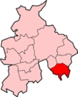
Rossendale is a local government district
with borough
status. It is made up of a number of small former mill towns in Lancashire
, England
centered around the valley of the River Irwell
in the industrial North West
. The district combines urban with rural aspects, and is close to the more populated areas of Bolton
, Burnley
, Bury
, Manchester
and Rochdale
.
In the 2001 census
the population of Rossendale was 65,652
(Government census records),
spread between the larger towns of Bacup
, Haslingden
and Rawtenstall
; the villages of Crawshawbooth
, Edenfield
, Helmshore
, Waterfoot
, Whitworth
; and as well as Britannia
, Chatterton
, Cloughfold
, Cowpe, Irwell Vale
, Newchurch
, Shawforth
, Stacksteads
, Stubbins
, Turn
, Water, Weir
.
The district was formed on April 1, 1974 under the Local Government Act 1972
, from the municipal borough
s of Bacup, Haslingden, Rawtenstall, part of Ramsbottom Urban District
and Whitworth Urban District
.
Rossendale is twinned with the German
town of Bocholt
, located close to the Netherlands
border.
The name "Rossendale" may also refer geographically to Rossendale Valley
, and historically refers to the medieval Forest or "Chase" of Rossendale, which encompassed approximately the same area as the modern district.
Rossendale is part of the Forest of Rossendale, which consists of the steep-sided valleys of the River Irwell and its tributaries, which flow from the Pennines
southwards to Manchester and cut through the moorland which is characteristic of the area.
Non-metropolitan district
Non-metropolitan districts, or colloquially shire districts, are a type of local government district in England. As created, they are sub-divisions of non-metropolitan counties in a so-called "two-tier" arrangement...
with borough
Borough
A borough is an administrative division in various countries. In principle, the term borough designates a self-governing township although, in practice, official use of the term varies widely....
status. It is made up of a number of small former mill towns in Lancashire
Lancashire
Lancashire is a non-metropolitan county of historic origin in the North West of England. It takes its name from the city of Lancaster, and is sometimes known as the County of Lancaster. Although Lancaster is still considered to be the county town, Lancashire County Council is based in Preston...
, England
England
England is a country that is part of the United Kingdom. It shares land borders with Scotland to the north and Wales to the west; the Irish Sea is to the north west, the Celtic Sea to the south west, with the North Sea to the east and the English Channel to the south separating it from continental...
centered around the valley of the River Irwell
River Irwell
The River Irwell is a long river which flows through the Irwell Valley in the counties of Lancashire and Greater Manchester in North West England. The river's source is at Irwell Springs on Deerplay Moor, approximately north of Bacup, in the parish of Cliviger, Lancashire...
in the industrial North West
North West England
North West England, informally known as The North West, is one of the nine official regions of England.North West England had a 2006 estimated population of 6,853,201 the third most populated region after London and the South East...
. The district combines urban with rural aspects, and is close to the more populated areas of Bolton
Bolton
Bolton is a town in Greater Manchester, in the North West of England. Close to the West Pennine Moors, it is north west of the city of Manchester. Bolton is surrounded by several smaller towns and villages which together form the Metropolitan Borough of Bolton, of which Bolton is the...
, Burnley
Burnley
Burnley is a market town in the Burnley borough of Lancashire, England, with a population of around 73,500. It lies north of Manchester and east of Preston, at the confluence of the River Calder and River Brun....
, Bury
Bury
Bury is a town in Greater Manchester, England. It lies on the River Irwell, east of Bolton, west-southwest of Rochdale, and north-northwest of the city of Manchester...
, Manchester
Manchester
Manchester is a city and metropolitan borough in Greater Manchester, England. According to the Office for National Statistics, the 2010 mid-year population estimate for Manchester was 498,800. Manchester lies within one of the UK's largest metropolitan areas, the metropolitan county of Greater...
and Rochdale
Rochdale
Rochdale is a large market town in Greater Manchester, England. It lies amongst the foothills of the Pennines on the River Roch, north-northwest of Oldham, and north-northeast of the city of Manchester. Rochdale is surrounded by several smaller settlements which together form the Metropolitan...
.
In the 2001 census
United Kingdom Census 2001
A nationwide census, known as Census 2001, was conducted in the United Kingdom on Sunday, 29 April 2001. This was the 20th UK Census and recorded a resident population of 58,789,194....
the population of Rossendale was 65,652
(Government census records),
spread between the larger towns of Bacup
Bacup
Bacup is a town within the Rossendale borough of Lancashire, England. It is located amongst the South Pennines, along Lancashire's eastern boundary with West Yorkshire. The town sits within a rural setting in the Forest of Rossendale, amongst the steep-sided upper-Irwell Valley, through which the...
, Haslingden
Haslingden
Haslingden is a small town in Rossendale, Lancashire, England. It is north of Manchester. The name means 'valley of the hazels', though the town is in fact set on a high and windy hill. In the early 20th century Haslingden had the status of a municipal borough, but following local government...
and Rawtenstall
Rawtenstall
Rawtenstall is a town at the centre of the Rossendale Valley, in Lancashire, England. It is the seat for the Borough of Rossendale, in which it is located. The town lies 18 miles north of Manchester, 22 miles east of the county town of Preston and 45 miles south east of Lancaster...
; the villages of Crawshawbooth
Crawshawbooth
Crawshawbooth is a small village on the edge of the Pennine Hills in England just north of the market town of Rawtenstall, Lancashire, and just south of Loveclough. It is part of the valley of Rossendale, an ancient royal hunting ground...
, Edenfield
Edenfield
Edenfield is a village within the Rossendale borough of Lancashire, England. Lying on the River Irwell, it is around north of Ramsbottom, south of Rawtenstall, and west of Norden, and has a total population of 2,080....
, Helmshore
Helmshore
Helmshore is a village in the Rossendale Valley, Lancashire, England. It is situated south of Haslingden, broadly between the A56 and the B6235, approximately 16 miles north of Manchester.- Early history :...
, Waterfoot
Waterfoot, Rossendale
Waterfoot is a small Rossendale mill-town at between Rawtenstall and Bacup in Lancashire where the B6238 from Burnley meets the A681. It is where the River Whitwell meets the River Irwell.- History :...
, Whitworth
Whitworth, Lancashire
Whitworth is a town and civil parish within the Borough of Rossendale in Lancashire, England. It is set amongst the foothills of the Pennines, between the towns of Bacup, to the north, and Rochdale, to the south. It has a population of 7,263....
; and as well as Britannia
Britannia, Lancashire
Britannia is a suburb of Bacup in the Rossendale borough of Lancashire, England. It lies on the course of two major roads and has a school and a nature reserve. Rochdale is to the south. Inchfield Moor in West Yorkshire is to the east....
, Chatterton
Chatterton, Lancashire
Chatterton is a small village in the southern part of the Rossendale Valley, Lancashire.It is half a mile north of Ramsbottom town centre on the A676 between Bolton and Edenfield. For local government purposes, it receives services from Rossendale Borough Council and Lancashire County Council....
, Cloughfold
Cloughfold
Cloughfold is a small hamlet in between the towns of Rawtenstall and Waterfoot in Rossendale, Lancashire.There also used to be a railway station there, Clough Fold railway station on the Rawtenstall to Bacup Line, which was opened in 1871 and closed when the line closed in 1966....
, Cowpe, Irwell Vale
Irwell Vale
Irwell Vale is a village within the Rossendale borough of Lancashire, in North West England. which lies at the confluence of the River Ogden and River Irwell....
, Newchurch
Newchurch, Lancashire
Newchurch is a village in the Borough of Rossendale, Lancashire.It is around one mile away from Rawtenstall and half a mile from Waterfoot.It is also the home of Rossendale United F.C...
, Shawforth
Shawforth
Shawforth is a suburban village within the Rossendale borough of Lancashire, England. It lies amongst the South Pennines along the course of the River Spodden and A671 road...
, Stacksteads
Stacksteads
Stacksteads is a village between the towns Bacup and Waterfoot in Rossendale, Lancashire, England. Stacksteads includes a quarry called Lee Quarry which has also been transformed into a mountain bike trail.-History:...
, Stubbins
Stubbins
Stubbins is an industrial village in the southern part of the Rossendale Valley, Lancashire.It is half a mile north of Ramsbottom town centre on the A676 between Bolton and Edenfield. For local government purposes, it receives services from Rossendale Borough Council and Lancashire County Council...
, Turn
Turn Village
Turn Village is a hamlet in the Rossendale borough of Lancashire, England. It is located amongst the South Pennines, on the A680 road and is effectively a suburb of Edenfield....
, Water, Weir
Weir, Lancashire
Weir is an outlying area of Bacup in the Rossendale borough of Lancashire, England. Anciently, Weir constituted a hamlet, but underwent urbanisation and, later, suburbanisation to emerge as a residential suburb of Bacup town....
.
The district was formed on April 1, 1974 under the Local Government Act 1972
Local Government Act 1972
The Local Government Act 1972 is an Act of Parliament in the United Kingdom that reformed local government in England and Wales on 1 April 1974....
, from the municipal borough
Municipal borough
Municipal boroughs were a type of local government district which existed in England and Wales between 1835 and 1974, in Northern Ireland from 1840 to 1973 and in the Republic of Ireland from 1840 to 2002...
s of Bacup, Haslingden, Rawtenstall, part of Ramsbottom Urban District
Ramsbottom Urban District
Ramsbottom Urban District was, from 1894 to 1974, a local government district of the administrative county of Lancashire, England. Its area was coterminate with Ramsbottom, spanning an area of the Rossendale Valley north of the County Borough of Bury....
and Whitworth Urban District
Urban district
In the England, Wales and Ireland, an urban district was a type of local government district that covered an urbanised area. Urban districts had an elected Urban District Council , which shared local government responsibilities with a county council....
.
Rossendale is twinned with the German
Germany
Germany , officially the Federal Republic of Germany , is a federal parliamentary republic in Europe. The country consists of 16 states while the capital and largest city is Berlin. Germany covers an area of 357,021 km2 and has a largely temperate seasonal climate...
town of Bocholt
Bocholt, Germany
Bocholt is a city in the north-west of North Rhine-Westphalia, Germany, part of the district Borken. It is situated 4 km south of the border with the Netherlands.-Geography:...
, located close to the Netherlands
Netherlands
The Netherlands is a constituent country of the Kingdom of the Netherlands, located mainly in North-West Europe and with several islands in the Caribbean. Mainland Netherlands borders the North Sea to the north and west, Belgium to the south, and Germany to the east, and shares maritime borders...
border.
The name "Rossendale" may also refer geographically to Rossendale Valley
Rossendale Valley
The Rossendale Valley is part of the Forest of Rossendale, an upland area of North West England, in Lancashire. The area is within the Borough of Rossendale...
, and historically refers to the medieval Forest or "Chase" of Rossendale, which encompassed approximately the same area as the modern district.
Rossendale is part of the Forest of Rossendale, which consists of the steep-sided valleys of the River Irwell and its tributaries, which flow from the Pennines
Pennines
The Pennines are a low-rising mountain range, separating the North West of England from Yorkshire and the North East.Often described as the "backbone of England", they form a more-or-less continuous range stretching from the Peak District in Derbyshire, around the northern and eastern edges of...
southwards to Manchester and cut through the moorland which is characteristic of the area.
Discussions