
Woodhead Reservoir
Encyclopedia
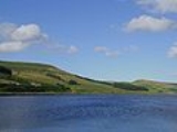
Woodhead reservoir is a man-made lake near the hamlet of Woodhead
in Longdendale
in north Derbyshire
. It was constructed by John Frederick Bateman
between 1847 and June 1877 as part of the Longdendale chain
to supply water from the River Etherow
to the urban areas of Greater Manchester
. It is at the top the chain of reservoirs and was the first to be started, though, due to construction problems, it was the last to be completed.
s and the aqueduct of the Mottram Tunnel
. the Manchester Corporation Waterworks Act 1848 allowed the construction of Torside
and Rhodeswood Reservoir
, and an aqueduct to convey the water from Rhodeswood to the Arnfield reservoir. These acts were important, as millowners relied for their livings on water to power their mills and any potential reduction of supply was opposed. The acts guaranteed a flow of 121 million gallons a week.
To stop the leak, borings had been made, and ash injected under pressure in the hope it would act as a sealant. In 1858, it was concluded that this would not work; the Etherow valley was on multiple fissures relating to a fault that was causing movement in the soft beds of shale underlying the harder rock beneath the valley. This was the cause of the landslides at Rhodeswood, and the continual problems at Woodhead.
The storage level of the reservoir remained the same but the embankment crest was raised by 6.7 metres (22 ft), which meant replacing the B6105 road at a higher level and on a new course. An impervious clay membrane was laid in the upstream face to provide continuity with the 1877 embankment. This was protected with concrete matting faced in stone. The length of the overflow sill was reduced and a new concrete box section installed to throttle the flow, which was directed into the Etherow Pool. A replacement 1400 millimetres (55.1 in) diameter guard valve was installed.
Woodhead
Woodhead is a small and scattered settlement at the head of the Longdendale valley in Derbyshire, England, situated 18 miles from Manchester and 17 miles from Barnsley. It lies on the River Etherow and the Trans Pennine Trail...
in Longdendale
Longdendale
Longdendale is a valley in the north of England, north of Glossop and south east of Holmfirth. The name means "long wooded valley".- Geography :...
in north Derbyshire
Derbyshire
Derbyshire is a county in the East Midlands of England. A substantial portion of the Peak District National Park lies within Derbyshire. The northern part of Derbyshire overlaps with the Pennines, a famous chain of hills and mountains. The county contains within its boundary of approx...
. It was constructed by John Frederick Bateman
John Frederick Bateman
John Frederick Bateman was an English civil engineer whose work formed the basis of the modern United Kingdom water supply industry. For over 50 years from 1835 he designed and constructed reservoirs and waterworks. His largest project was the system that supplied Manchester with much of its...
between 1847 and June 1877 as part of the Longdendale chain
Longdendale Chain
The Longdendale Chain is a sequence of six reservoirs on the River Etherow in the valley of Longdendale, in northern Derbyshire. They were constructed between 1848 and 1884 to a design by John Frederick Bateman to supply the growing population of Manchester and Salford with fresh water.The top...
to supply water from the River Etherow
River Etherow
The River Etherow is a river in northern England, and a tributary of the River Goyt. Although now passing through South Yorkshire, Derbyshire and Greater Manchester, it historically formed the ancient county boundary between Cheshire and Derbyshire. The upper valley is known as Longdendale...
to the urban areas of Greater Manchester
Greater Manchester
Greater Manchester is a metropolitan county in North West England, with a population of 2.6 million. It encompasses one of the largest metropolitan areas in the United Kingdom and comprises ten metropolitan boroughs: Bolton, Bury, Oldham, Rochdale, Stockport, Tameside, Trafford, Wigan, and the...
. It is at the top the chain of reservoirs and was the first to be started, though, due to construction problems, it was the last to be completed.
Act of Parliament
The Manchester Corporation Waterworks Act 1847 gave permission for the construction of the Woodhead and Arnfield reservoirArnfield Reservoir
Arnfield Reservoir is a man-made lake in Longdendale in north Derbyshire. It was constructed in 1854 as part of the Longdendale chain to supply water from the River Etherow to the urban areas of Greater Manchester. Unlike the other reservoirs in the chain, Arnfield and Hollingworth Reservoir are...
s and the aqueduct of the Mottram Tunnel
Mottram Tunnel
The Mottram Tunnel is a tunnel carrying drinking water by gravity from Arnfield Reservoir, Tintwistle, Derbyshire in the valley of the River Etherow, to Godley, Greater Manchester in the valley of the River Tame. It was essential to the construction of the Longdendale Chain of reservoirs...
. the Manchester Corporation Waterworks Act 1848 allowed the construction of Torside
Torside Reservoir
Torside Reservoir is the largest man-made lake in Longdendale in north Derbyshire. It was constructed by John Frederick Bateman between April 1849 and July 1864 as part of the Longdendale chain to supply water from the River Etherow to the urban areas of Greater Manchester.The Manchester...
and Rhodeswood Reservoir
Rhodeswood Reservoir
Rhodeswood Reservoir is a man-made lake in Longdendale in north Derbyshire. It was constructed by John Frederick Bateman between 1849 and June 1855 as part of the Longdendale chain to supply water from the River Etherow to the urban areas of Greater Manchester...
, and an aqueduct to convey the water from Rhodeswood to the Arnfield reservoir. These acts were important, as millowners relied for their livings on water to power their mills and any potential reduction of supply was opposed. The acts guaranteed a flow of 121 million gallons a week.
Construction
The construction of the Woodhead Embankment was ambitious and fraught with difficulties. The embankment was to be about 90 feet (27.4 m) in height; it was sealed to the underlying impermeable rock by a central impermeable clay puddle core or curtain. This was supported on each side by selected strong earth material, and then gravel to form a slope of 1 in 1 upstream and 1 in 2 downstream. The upstream would be pitched, and faced in stone. The turnpike would pass over the crest. Drinking water would be extracted by means of a tunnel from several metres below the water level, while when full, excess water would pass over the overspill or waste weir.The first embankment
Work started in 1848. The Heyden Viaduct, now known as the Woodhead Bridge, was completed in 1851, and turned over to the Salters Brook turnpike road that year. The Woodhead embankment was 20 feet (6 m) from completion. Discharge valves had been supplied by Messrs Armstrong and Co, of Newcastle-upon-Tyne. There was some leakage but on 10 May 1854 the Woodhead Reservoir was declared complete, with the exception of remedying the leak.To stop the leak, borings had been made, and ash injected under pressure in the hope it would act as a sealant. In 1858, it was concluded that this would not work; the Etherow valley was on multiple fissures relating to a fault that was causing movement in the soft beds of shale underlying the harder rock beneath the valley. This was the cause of the landslides at Rhodeswood, and the continual problems at Woodhead.
The second embankment
In 1862 a second embankment downstream of the first embankment was proposed. This took advantage of a continuous length of shale suitable for a seal. The space between the two embankments was infilled. The new puddle trench was sunk 160 feet (48.8 m) beneath the height of the first embankment, 60 feet (18.3 m) below the old riverbed, in the main through solid rock. It was filled with concrete as clay could not withstand a water head of 160 feet. The reservoir was filled in 1877.Safety measures
It was stated in a statutory report, under the Reservoir Safety Act 1975, dated 12 June, that all five reservoirs could be over-topped during a Probable Maximum Flood. Woodhead as the fountainhead had the most drastic improvements, relieving the pressure on the other reservoirs. The work took place between 1989 and 1992 at a cost of £3m.The storage level of the reservoir remained the same but the embankment crest was raised by 6.7 metres (22 ft), which meant replacing the B6105 road at a higher level and on a new course. An impervious clay membrane was laid in the upstream face to provide continuity with the 1877 embankment. This was protected with concrete matting faced in stone. The length of the overflow sill was reduced and a new concrete box section installed to throttle the flow, which was directed into the Etherow Pool. A replacement 1400 millimetres (55.1 in) diameter guard valve was installed.