
Clayrack Drainage Mill
Encyclopedia
Clayrack Drainage Windmill is located at How Hill in the English
county
of Norfolk
. It is on the east bank of the River Ant
close to How Hill House, a large Edwardian building which houses the Norfolk Broads Study Centre
. The Drainage mill is 1¾ miles west of the village of Ludham
.
. The mill was in a terrible state of repair and was in danger of being lost for ever. It was decided that it was worth saving and a restoration program was set up. As Ranworth marsh hosted many nesting birds who would have been vulnerable to any disturbance caused by the work the decision was taken to move Clayrack windpump to its present position at How Hill
l. Now fully restored the mill can sometimes be seen operating in its original capacity as a drainage pump.
England
England is a country that is part of the United Kingdom. It shares land borders with Scotland to the north and Wales to the west; the Irish Sea is to the north west, the Celtic Sea to the south west, with the North Sea to the east and the English Channel to the south separating it from continental...
county
County
A county is a jurisdiction of local government in certain modern nations. Historically in mainland Europe, the original French term, comté, and its equivalents in other languages denoted a jurisdiction under the sovereignty of a count A county is a jurisdiction of local government in certain...
of Norfolk
Norfolk
Norfolk is a low-lying county in the East of England. It has borders with Lincolnshire to the west, Cambridgeshire to the west and southwest and Suffolk to the south. Its northern and eastern boundaries are the North Sea coast and to the north-west the county is bordered by The Wash. The county...
. It is on the east bank of the River Ant
River Ant
The River Ant is a tributary river of the River Bure in the county of Norfolk, England. It is 17 miles long , and has an overall drop of 25 metres from source to mouth...
close to How Hill House, a large Edwardian building which houses the Norfolk Broads Study Centre
. The Drainage mill is 1¾ miles west of the village of Ludham
Ludham
Ludham is a village and civil parish in the English county of Norfolk, in The Broads, at the end of a dyke leading to Womack Water and flowing into the River Thurne...
.
Description
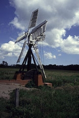
Clayrack Drainage Windmill is of an interesting design being one of only two ‘Hollow Post’ drainage mills left on the broads and the only one fitted with a scoop wheel. The mill has a miniature cap, sails and fantail based on its more traditional big brother tower drainage mills which can be seen on other parts of the Norfolk Broads.Just to the south of this windmill on the same side of the river Ant is another small interesting drainage windmill called Boardman’s Windmill. Clayrack takes its name from the Fen it stands on.History
Clayrack drainage windmill is not on its original position. It was moved in 1981 from its previous site on Ranworth Marshes 2¾ miles away on the other bank of the River AntRiver Ant
The River Ant is a tributary river of the River Bure in the county of Norfolk, England. It is 17 miles long , and has an overall drop of 25 metres from source to mouth...
. The mill was in a terrible state of repair and was in danger of being lost for ever. It was decided that it was worth saving and a restoration program was set up. As Ranworth marsh hosted many nesting birds who would have been vulnerable to any disturbance caused by the work the decision was taken to move Clayrack windpump to its present position at How Hill
How Hill
How Hill lies on the River Ant within The Broads National Park in Norfolk, England.The large Edwardian building houses the Norfolk Broads Study Centre, an independent charitable organisation which runs residential environmental courses for groups of schoolchildren.The How Hill Nature Reserve is...
l. Now fully restored the mill can sometimes be seen operating in its original capacity as a drainage pump.