
Smallburgh
Encyclopedia
Smallburgh is a village and a civil parish
in the English
county of Norfolk
. The village is fourteen miles (21 km) south-east of Cromer
, fourteen miles (21 km) north-east of Norwich
and 132 miles (212.4 km) north-east of London
. The village lies five miles (8 km) south-east of the nearby town of North Walsham
. The nearest railway station is at Worstead
for the Bittern Line
which runs between Sheringham
, Cromer and Norwich. The nearest airport is Norwich International Airport
. As of the 2001 census
it had a population of 518 in 219 households.
For the purposes of local government, it falls within the district
of North Norfolk
.
that links King’s Lynn to Great Yarmouth
. The community is bordered to the north and east by the River Ant
and dykes and to the south and west by tracks and hedgerows. The name of the village comes from 'Bank of the River Smale', the Smale being the old name for the River Ant
. Smale itself derives from Old English
word smale or beorg which means hillock
.
settlement. In the great survey of 1086, known as the Domesday Book
, the settlement of Smallburgh is described as being a quiet, small place. There are two entries in the book. The first entry states that a freeman
of St Benedict's held IC of Freeland. He gave it to St Benedict before 1066 but still held it from the Abbot
. There are 2 villagers with 1.5 lengths of plough
land and 2 acres (8,093.7 m²) of meadow, the value of this being 20 shillings. In the same village were 28 freemen, 1c of land, always 4 ploughs and 1 acres (4,046.9 m²) of meadow, the value of this being 20s. The whole has 10 furlong
s and 12 perches in length and 6 furlongs in width, the tax
for this being 1 penny
.
The second entry recorded that in Smallburgh there are 3 freemen and 1c of land. Always there are 12 smallholdings and 3 freemen. Then and later 3 ploughs, now 4. Two of these are in the valuation of Antingham; the value of the third is 10 shilling
s.
In 1588 the village was split with there being two main areas of settlement. The first part being the present village centre and the area around Low Street which was a considerable-sized hamnet
and this constituted the manor of Smallburgh. The second part was situated at the present Holly House and was known as the manor of Smallburgh Catts. This is because the lord of the manor at that time was Robert Catte. He enclosed much common land and that is why the area towards the Norwich
Road is known as Catt's Common. Much of the land in Smallburgh Catts was cultivated in the traditional strip system
with a large area of common land
to the south and west. The present streets of Union Road and Anchor Street are reputed to be part of a Roman Road
leading to the Roman camp near Wayford Bridge
.
White’s Directory
of 1845 states that Smallburgh had two shoemakers, blacksmith
, surgeon
, Jeremiah Hannant of the Crown Inn was a joiner
and victualler, wheelwright
, grocer
, draper
, school mistress and school, a shopkeeper
, surgeon, another blacksmith and furrier, tailor
, plumber
and painter
.
White’s of 1864 indicates a still-thriving community, with many occupations being centred in the village. These include carpenters, bricklayer
s, plumber, shoemaker, grocer and draper, surgeon and registrar, blacksmith, a master of the workhouse, a mistress of the school, three public or beer houses, carrier, tailor, rector
, book-keeper, many farmers and smallholders.
In more recent times the life in the village has changed. Since the end of the Second World War the village has had only one public house, The Crown. The village still retains a post office
and the church remains open. However the school closed in the 1980s.
 A large workhouse
was located at the east side of what is still known as Workhouse Road in the village. It was built in 1725 and extended in 1836. It appears to have had a large H-shaped main building with a number of other smaller ancillary buildings. Records indicate that the workhouse could accommodate 800 souls although in 1876 there were only 51 people there; however, the highest number staying there between 1866 and 1876 was 116 in January 1869. Other records show that the annual salaries bill for the officers and those who worked at the Union Workhouse was £293. The Tunstead workhouse issued its own coinage in the form of workhouse tokens in the early 19th century when there was a national shortage of copper coins. The tokens could be spent locally to buy bread
and other basic commodities. The graveyard where people were buried when they died in the workhouse lies to the south of the site. The Union Workhouse, for the Hundreds of Tunstead
, as it was known, closed its doors when the National Health Service
was founded in 1948 and much of the old workhouse was demolished in the 1950s. It is thought that because the workhouse was situated in the village, the local district council was the Smallburgh Rural District Council and, indeed, members of that council met in the board room of the workhouse until its closure. The Smallburgh Rural District Council then met in special council offices in Stalham
until its demise on 31 March 1974, when it was subsumed within the North Norfolk
District Council under local government re-organization.
building. The first rector recorded is Henry Hemingburgh, in 1305, but the register of St Benet-at-Holme records the presentation of John of Smallburgh as rector in 1186. In 1677 the church tower collapsed bringing down the west wall with it and damaging the font
. For many years the church was in a state of disrepair. A makeshift tower was constructed in 1822 but in 1902 the present bell cote was constructed and the west wall rebuilt. The long timescale of these repairs was because the village was very poor at that time, and the church had to use its money for the care of the poor. The church is still in use and is open for worship.
can be found the remains of what was Smallburgh or Moy's drainage mill
. The mill was built to drain the marshes into the river. The mill's name relates to Percy M. Moy who lived at Smallburgh Manor in the 1920s and ran Manor Farm containing land drained by the mill. The mill only had a small tower which was later heightened and in later years two pairs of patent sails, each with five bays of shutters, were fitted along with a very small cap, a gallery and an eight-bladed fan. The sails of the mill powered a scoopwheel which was set on a shaft which extended beyond the wheel to allow for an auxiliary engine drive. The mill was still working under wind power in 1935. Today all that remains is an 8 ft (2.4 m) high stump of the mill tower although it is still working but has a Lister diesel engine to power it.
stands Smallburgh tower windmill. The mill was built in 1850 by millwrights England’s of Ludham
and stood four storeys and 30 feet (9.1 m) tall. The diameter
at the base of the mill measures 14 feet (4.3 m), and the walls are 18 inches (457.2 mm) thick. The configuration of the mill was of four double-shuttered patent sails, each with five bays of three shutters and one bay of four shutters, struck by rack and pinion via a chain pole that drove a 14 feet (4.3 m) by 9 inches (228.6 mm) scoop wheel and a pair of under driven 3 in 6 in (1.07 m) French burr stones on the first floor. The Norfolk boat-shaped cap had a petticoat at the sides and an extension to the horizontally-boarded front. The cap was turned to wind by a fan of eight blades. Today the mill no longer has its cap, although in 1984 the Broads Authority
approved permission to install a new cap, fan stage and sails which still has not yet been completed. A bungalow
has been attached to the mill's main body.
 The Crown Inn is situated on the eastern side of the A149 road
that runs through the centre of the village. It is a 15th-century coaching inn
with a great deal of history. It is of timber-framed
construction and has a thatched roof
hipped on the eastern side and gabled on the western end. The once-large upper room above the bar has now been divided into rooms by stud walls, but was once used for public occasions. The Crown was enlarged with an extra wing in the 18th century.
Civil parish
In England, a civil parish is a territorial designation and, where they are found, the lowest tier of local government below districts and counties...
in the English
England
England is a country that is part of the United Kingdom. It shares land borders with Scotland to the north and Wales to the west; the Irish Sea is to the north west, the Celtic Sea to the south west, with the North Sea to the east and the English Channel to the south separating it from continental...
county of Norfolk
Norfolk
Norfolk is a low-lying county in the East of England. It has borders with Lincolnshire to the west, Cambridgeshire to the west and southwest and Suffolk to the south. Its northern and eastern boundaries are the North Sea coast and to the north-west the county is bordered by The Wash. The county...
. The village is fourteen miles (21 km) south-east of Cromer
Cromer
Cromer is a coastal town and civil parish in north Norfolk, England. The local government authority is North Norfolk District Council, whose headquarters is in Holt Road in the town. The town is situated 23 miles north of the county town, Norwich, and is 4 miles east of Sheringham...
, fourteen miles (21 km) north-east of Norwich
Norwich
Norwich is a city in England. It is the regional administrative centre and county town of Norfolk. During the 11th century, Norwich was the largest city in England after London, and one of the most important places in the kingdom...
and 132 miles (212.4 km) north-east of London
London
London is the capital city of :England and the :United Kingdom, the largest metropolitan area in the United Kingdom, and the largest urban zone in the European Union by most measures. Located on the River Thames, London has been a major settlement for two millennia, its history going back to its...
. The village lies five miles (8 km) south-east of the nearby town of North Walsham
North Walsham
North Walsham is a market town and civil parish in Norfolk, England in the North Norfolk district.-Demographics:The civil parish has an area of and in the 2001 census had a population of 11,998. For the purposes of local government, the parish falls within the district of North...
. The nearest railway station is at Worstead
Worstead railway station
Worstead is a railway station situated about 1 km distant from the villages of Worstead and Sloley in the English county of Norfolk. The station is served by local services operated by National Express East Anglia on the Bittern Line from Norwich to Cromer and Sheringham.-Train Services:The...
for the Bittern Line
Bittern Line
The Bittern Line is a railway line from Norwich to Cromer then Sheringham in Norfolk, England. It is one of the most scenic in the East of England traversing the Norfolk Broads on its route to the Area of Outstanding Natural Beauty on the North Norfolk Coast. The line is part of the Network Rail...
which runs between Sheringham
Sheringham
Sheringham is a seaside town in Norfolk, England, west of Cromer.The motto of the town, granted in 1953 to the Sheringham Urban District Council, is Mare Ditat Pinusque Decorat, Latin for "The sea enriches and the pine adorns"....
, Cromer and Norwich. The nearest airport is Norwich International Airport
Norwich International Airport
Norwich International Airport , also known as Norwich Airport, is an airport in the City of Norwich within Norfolk, England north of the city centre and on the edge of the city's suburbs....
. As of the 2001 census
United Kingdom Census 2001
A nationwide census, known as Census 2001, was conducted in the United Kingdom on Sunday, 29 April 2001. This was the 20th UK Census and recorded a resident population of 58,789,194....
it had a population of 518 in 219 households.
For the purposes of local government, it falls within the district
Non-metropolitan district
Non-metropolitan districts, or colloquially shire districts, are a type of local government district in England. As created, they are sub-divisions of non-metropolitan counties in a so-called "two-tier" arrangement...
of North Norfolk
North Norfolk
North Norfolk is a local government district in Norfolk, United Kingdom. Its council is based in Cromer. The council headquarters can be found approximately out of the town of Cromer on the Holt Road.-History:...
.
Portrait
Smallburgh is a sprawling village over an area of 1255 acres (5.1 km²). The village straddles the A149 roadA149 road
The A149 is a major route in Norfolk, linking Kings Lynn to Great Yarmouth. It runs via the coast rather than on a more direct route such as the A47. The eastern section runs through The Broads.-Kings Lynn to Wells next the Sea:...
that links King’s Lynn to Great Yarmouth
Great Yarmouth
Great Yarmouth, often known to locals as Yarmouth, is a coastal town in Norfolk, England. It is at the mouth of the River Yare, east of Norwich.It has been a seaside resort since 1760, and is the gateway from the Norfolk Broads to the sea...
. The community is bordered to the north and east by the River Ant
River Ant
The River Ant is a tributary river of the River Bure in the county of Norfolk, England. It is 17 miles long , and has an overall drop of 25 metres from source to mouth...
and dykes and to the south and west by tracks and hedgerows. The name of the village comes from 'Bank of the River Smale', the Smale being the old name for the River Ant
River Ant
The River Ant is a tributary river of the River Bure in the county of Norfolk, England. It is 17 miles long , and has an overall drop of 25 metres from source to mouth...
. Smale itself derives from Old English
Old English language
Old English or Anglo-Saxon is an early form of the English language that was spoken and written by the Anglo-Saxons and their descendants in parts of what are now England and southeastern Scotland between at least the mid-5th century and the mid-12th century...
word smale or beorg which means hillock
Hillock
A hillock or knoll is a small hill, usually separated from a larger group of hills such as a range. Hillocks are similar in their distribution and size to small mesas or buttes. The term is largely a British one...
.
History
It is believed locally that the field to the north of the church was the site of the original SaxonAnglo-Saxons
Anglo-Saxon is a term used by historians to designate the Germanic tribes who invaded and settled the south and east of Great Britain beginning in the early 5th century AD, and the period from their creation of the English nation to the Norman conquest. The Anglo-Saxon Era denotes the period of...
settlement. In the great survey of 1086, known as the Domesday Book
Domesday Book
Domesday Book , now held at The National Archives, Kew, Richmond upon Thames in South West London, is the record of the great survey of much of England and parts of Wales completed in 1086...
, the settlement of Smallburgh is described as being a quiet, small place. There are two entries in the book. The first entry states that a freeman
Serfdom
Serfdom is the status of peasants under feudalism, specifically relating to Manorialism. It was a condition of bondage or modified slavery which developed primarily during the High Middle Ages in Europe and lasted to the mid-19th century...
of St Benedict's held IC of Freeland. He gave it to St Benedict before 1066 but still held it from the Abbot
Abbot
The word abbot, meaning father, is a title given to the head of a monastery in various traditions, including Christianity. The office may also be given as an honorary title to a clergyman who is not actually the head of a monastery...
. There are 2 villagers with 1.5 lengths of plough
Plough
The plough or plow is a tool used in farming for initial cultivation of soil in preparation for sowing seed or planting. It has been a basic instrument for most of recorded history, and represents one of the major advances in agriculture...
land and 2 acres (8,093.7 m²) of meadow, the value of this being 20 shillings. In the same village were 28 freemen, 1c of land, always 4 ploughs and 1 acres (4,046.9 m²) of meadow, the value of this being 20s. The whole has 10 furlong
Furlong
A furlong is a measure of distance in imperial units and U.S. customary units equal to one-eighth of a mile, equivalent to 220 yards, 660 feet, 40 rods, or 10 chains. The exact value of the furlong varies slightly among English-speaking countries....
s and 12 perches in length and 6 furlongs in width, the tax
Tax
To tax is to impose a financial charge or other levy upon a taxpayer by a state or the functional equivalent of a state such that failure to pay is punishable by law. Taxes are also imposed by many subnational entities...
for this being 1 penny
Penny
A penny is a coin or a type of currency used in several English-speaking countries. It is often the smallest denomination within a currency system.-Etymology:...
.
The second entry recorded that in Smallburgh there are 3 freemen and 1c of land. Always there are 12 smallholdings and 3 freemen. Then and later 3 ploughs, now 4. Two of these are in the valuation of Antingham; the value of the third is 10 shilling
Shilling
The shilling is a unit of currency used in some current and former British Commonwealth countries. The word shilling comes from scilling, an accounting term that dates back to Anglo-Saxon times where it was deemed to be the value of a cow in Kent or a sheep elsewhere. The word is thought to derive...
s.
In 1588 the village was split with there being two main areas of settlement. The first part being the present village centre and the area around Low Street which was a considerable-sized hamnet
Hamlet (place)
A hamlet is usually a rural settlement which is too small to be considered a village, though sometimes the word is used for a different sort of community. Historically, when a hamlet became large enough to justify building a church, it was then classified as a village...
and this constituted the manor of Smallburgh. The second part was situated at the present Holly House and was known as the manor of Smallburgh Catts. This is because the lord of the manor at that time was Robert Catte. He enclosed much common land and that is why the area towards the Norwich
Norwich
Norwich is a city in England. It is the regional administrative centre and county town of Norfolk. During the 11th century, Norwich was the largest city in England after London, and one of the most important places in the kingdom...
Road is known as Catt's Common. Much of the land in Smallburgh Catts was cultivated in the traditional strip system
Open field system
The open field system was the prevalent agricultural system in much of Europe from the Middle Ages to as recently as the 20th century in some places, particularly Russia and Iran. Under this system, each manor or village had several very large fields, farmed in strips by individual families...
with a large area of common land
Common land
Common land is land owned collectively or by one person, but over which other people have certain traditional rights, such as to allow their livestock to graze upon it, to collect firewood, or to cut turf for fuel...
to the south and west. The present streets of Union Road and Anchor Street are reputed to be part of a Roman Road
Roman road
The Roman roads were a vital part of the development of the Roman state, from about 500 BC through the expansion during the Roman Republic and the Roman Empire. Roman roads enabled the Romans to move armies and trade goods and to communicate. The Roman road system spanned more than 400,000 km...
leading to the Roman camp near Wayford Bridge
Wayford Bridge
Wayford Bridge is a village on the River Ant on the A149 road, near Stalham in Norfolk, England within The Broads National Park.Due to height restrictions under the road bridge it is the most northerly point of navigation on the Norfolk Broads for boats over Wayford Bridge is a village on the River...
.
White’s Directory
Directory (databases)
Generally, a directory, as used in computing and telephony, refers to a repository or database of information which is heavily optimized for reading, under the assumption that data updates are very rare compared to data reads...
of 1845 states that Smallburgh had two shoemakers, blacksmith
Blacksmith
A blacksmith is a person who creates objects from wrought iron or steel by forging the metal; that is, by using tools to hammer, bend, and cut...
, surgeon
Surgeon
In medicine, a surgeon is a specialist in surgery. Surgery is a broad category of invasive medical treatment that involves the cutting of a body, whether human or animal, for a specific reason such as the removal of diseased tissue or to repair a tear or breakage...
, Jeremiah Hannant of the Crown Inn was a joiner
Joiner
A joiner differs from a carpenter in that joiners cut and fit joints in wood that do not use nails. Joiners usually work in a workshop since the formation of various joints generally requires non-portable machinery. A carpenter normally works on site...
and victualler, wheelwright
Wheelwright
A wheelwright is a person who builds or repairs wheels. The word is the combination of "wheel" and the archaic word "wright", which comes from the Old English word "wryhta", meaning a worker or maker...
, grocer
Grocer
A grocer is a bulk seller of food. Beginning as early as the 14th century, a grocer was a dealer in comestible dry goods such as spices, pepper, sugar, and cocoa, tea and coffee...
, draper
Draper
Draper is the now largely obsolete term for a wholesaler, or especially retailer, of cloth, mainly for clothing, or one who works in a draper's shop. A draper may additionally operate as a cloth merchant or a haberdasher. The drapers were an important trade guild...
, school mistress and school, a shopkeeper
Shopkeeper
A shopkeeper is an individual who owns a shop. Generally, shop employees are not shopkeepers, but are often incorrectly referred to as shopkeepers. Today, a shopkeeper is usually referred to as a manager, though this term could apply to larger firms .*In many south asian languages like Hindi, Urdu,...
, surgeon, another blacksmith and furrier, tailor
Tailor
A tailor is a person who makes, repairs, or alters clothing professionally, especially suits and men's clothing.Although the term dates to the thirteenth century, tailor took on its modern sense in the late eighteenth century, and now refers to makers of men's and women's suits, coats, trousers,...
, plumber
Plumber
A plumber is a tradesperson who specializes in installing and maintaining systems used for potable water, sewage, and drainage in plumbing systems. The term dates from ancient times, and is related to the Latin word for lead, "plumbum." A person engaged in fixing metaphorical "leaks" may also be...
and painter
Painting
Painting is the practice of applying paint, pigment, color or other medium to a surface . The application of the medium is commonly applied to the base with a brush but other objects can be used. In art, the term painting describes both the act and the result of the action. However, painting is...
.
White’s of 1864 indicates a still-thriving community, with many occupations being centred in the village. These include carpenters, bricklayer
Bricklayer
A bricklayer or mason is a craftsman who lays bricks to construct brickwork. The term also refers to personnel who use blocks to construct blockwork walls and other forms of masonry. In British and Australian English, a bricklayer is colloquially known as a "brickie".The training of a trade in...
s, plumber, shoemaker, grocer and draper, surgeon and registrar, blacksmith, a master of the workhouse, a mistress of the school, three public or beer houses, carrier, tailor, rector
Rector
The word rector has a number of different meanings; it is widely used to refer to an academic, religious or political administrator...
, book-keeper, many farmers and smallholders.
In more recent times the life in the village has changed. Since the end of the Second World War the village has had only one public house, The Crown. The village still retains a post office
Post office
A post office is a facility forming part of a postal system for the posting, receipt, sorting, handling, transmission or delivery of mail.Post offices offer mail-related services such as post office boxes, postage and packaging supplies...
and the church remains open. However the school closed in the 1980s.
The Workhouse
Workhouse
In England and Wales a workhouse, colloquially known as a spike, was a place where those unable to support themselves were offered accommodation and employment...
was located at the east side of what is still known as Workhouse Road in the village. It was built in 1725 and extended in 1836. It appears to have had a large H-shaped main building with a number of other smaller ancillary buildings. Records indicate that the workhouse could accommodate 800 souls although in 1876 there were only 51 people there; however, the highest number staying there between 1866 and 1876 was 116 in January 1869. Other records show that the annual salaries bill for the officers and those who worked at the Union Workhouse was £293. The Tunstead workhouse issued its own coinage in the form of workhouse tokens in the early 19th century when there was a national shortage of copper coins. The tokens could be spent locally to buy bread
Bread
Bread is a staple food prepared by cooking a dough of flour and water and often additional ingredients. Doughs are usually baked, but in some cuisines breads are steamed , fried , or baked on an unoiled frying pan . It may be leavened or unleavened...
and other basic commodities. The graveyard where people were buried when they died in the workhouse lies to the south of the site. The Union Workhouse, for the Hundreds of Tunstead
Tunstead, Norfolk
Tunstead is a village and a civil parish in the English county of Norfolk. The village is 10.7 miles north north east of the city of Norwich, 15 miles south south east of Cromer and 129 miles north east of London...
, as it was known, closed its doors when the National Health Service
National Health Service
The National Health Service is the shared name of three of the four publicly funded healthcare systems in the United Kingdom. They provide a comprehensive range of health services, the vast majority of which are free at the point of use to residents of the United Kingdom...
was founded in 1948 and much of the old workhouse was demolished in the 1950s. It is thought that because the workhouse was situated in the village, the local district council was the Smallburgh Rural District Council and, indeed, members of that council met in the board room of the workhouse until its closure. The Smallburgh Rural District Council then met in special council offices in Stalham
Stalham
Stalham is a market town on the River Ant in the English county of Norfolk, in East Anglia. It covers an area of and had a population of 2,951 in 1,333 households as of the 2001 census. It lies within the Norfolk Broads, about north-east of Norwich on the A149 road.For the purposes of local...
until its demise on 31 March 1974, when it was subsumed within the North Norfolk
North Norfolk
North Norfolk is a local government district in Norfolk, United Kingdom. Its council is based in Cromer. The council headquarters can be found approximately out of the town of Cromer on the Holt Road.-History:...
District Council under local government re-organization.
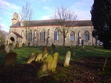
Parish Church
Smallburgh’s parish church is called St Peter’s and dates from the 13th century, with the walls being raised in height and large windows being incorporated into the building in 1400. The 13th-century church stands on the site of an earlier NormanNorman architecture
About|Romanesque architecture, primarily English|other buildings in Normandy|Architecture of Normandy.File:Durham Cathedral. Nave by James Valentine c.1890.jpg|thumb|200px|The nave of Durham Cathedral demonstrates the characteristic round arched style, though use of shallow pointed arches above the...
building. The first rector recorded is Henry Hemingburgh, in 1305, but the register of St Benet-at-Holme records the presentation of John of Smallburgh as rector in 1186. In 1677 the church tower collapsed bringing down the west wall with it and damaging the font
Baptismal font
A baptismal font is an article of church furniture or a fixture used for the baptism of children and adults.-Aspersion and affusion fonts:...
. For many years the church was in a state of disrepair. A makeshift tower was constructed in 1822 but in 1902 the present bell cote was constructed and the west wall rebuilt. The long timescale of these repairs was because the village was very poor at that time, and the church had to use its money for the care of the poor. The church is still in use and is open for worship.
The Methodist Church
Smallburgh Methodist Church is on Norwich Road. The church was built in the 17th century but the interior is recent and of no great interest.Smallburgh Drainage Mill
A short distance east of the village across the A149 and on the banks of the River AntRiver Ant
The River Ant is a tributary river of the River Bure in the county of Norfolk, England. It is 17 miles long , and has an overall drop of 25 metres from source to mouth...
can be found the remains of what was Smallburgh or Moy's drainage mill
Windpump
A windpump is a windmill used for pumping water, either as a source of fresh water from wells, or for draining low-lying areas of land. Once a common fixture on farms in semi-arid areas, windpumps are still used today where electric power is not available or too expensive.-History:Windmills were...
. The mill was built to drain the marshes into the river. The mill's name relates to Percy M. Moy who lived at Smallburgh Manor in the 1920s and ran Manor Farm containing land drained by the mill. The mill only had a small tower which was later heightened and in later years two pairs of patent sails, each with five bays of shutters, were fitted along with a very small cap, a gallery and an eight-bladed fan. The sails of the mill powered a scoopwheel which was set on a shaft which extended beyond the wheel to allow for an auxiliary engine drive. The mill was still working under wind power in 1935. Today all that remains is an 8 ft (2.4 m) high stump of the mill tower although it is still working but has a Lister diesel engine to power it.
Smallburgh Tower Windmill
Close to both Smallburgh and nearby Wayford BridgeWayford Bridge
Wayford Bridge is a village on the River Ant on the A149 road, near Stalham in Norfolk, England within The Broads National Park.Due to height restrictions under the road bridge it is the most northerly point of navigation on the Norfolk Broads for boats over Wayford Bridge is a village on the River...
stands Smallburgh tower windmill. The mill was built in 1850 by millwrights England’s of Ludham
Ludham
Ludham is a village and civil parish in the English county of Norfolk, in The Broads, at the end of a dyke leading to Womack Water and flowing into the River Thurne...
and stood four storeys and 30 feet (9.1 m) tall. The diameter
Diameter
In geometry, a diameter of a circle is any straight line segment that passes through the center of the circle and whose endpoints are on the circle. The diameters are the longest chords of the circle...
at the base of the mill measures 14 feet (4.3 m), and the walls are 18 inches (457.2 mm) thick. The configuration of the mill was of four double-shuttered patent sails, each with five bays of three shutters and one bay of four shutters, struck by rack and pinion via a chain pole that drove a 14 feet (4.3 m) by 9 inches (228.6 mm) scoop wheel and a pair of under driven 3 in 6 in (1.07 m) French burr stones on the first floor. The Norfolk boat-shaped cap had a petticoat at the sides and an extension to the horizontally-boarded front. The cap was turned to wind by a fan of eight blades. Today the mill no longer has its cap, although in 1984 the Broads Authority
Broads Authority
The Broads Authority is the agency which has statutory responsibility for the Broads in England. Originally, the Nature Conservancy Council , pressed for a special authority to manage the Broads which had been neglected for a long time. In 1978, the forerunner to the present-day Broads Authority...
approved permission to install a new cap, fan stage and sails which still has not yet been completed. A bungalow
Bungalow
A bungalow is a type of house, with varying meanings across the world. Common features to many of these definitions include being detached, low-rise , and the use of verandahs...
has been attached to the mill's main body.
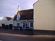
The Crown Inn
A149 road
The A149 is a major route in Norfolk, linking Kings Lynn to Great Yarmouth. It runs via the coast rather than on a more direct route such as the A47. The eastern section runs through The Broads.-Kings Lynn to Wells next the Sea:...
that runs through the centre of the village. It is a 15th-century coaching inn
Coaching inn
In Europe, from approximately the mid-17th century for a period of about 200 years, the coaching inn, sometimes called a coaching house or staging inn, was a vital part of the inland transport infrastructure, as an inn serving coach travelers...
with a great deal of history. It is of timber-framed
Timber framing
Timber framing , or half-timbering, also called in North America "post-and-beam" construction, is the method of creating structures using heavy squared off and carefully fitted and joined timbers with joints secured by large wooden pegs . It is commonplace in large barns...
construction and has a thatched roof
Thatching
Thatching is the craft of building a roof with dry vegetation such as straw, water reed, sedge , rushes, or heather, layering the vegetation so as to shed water away from the inner roof. It is a very old roofing method and has been used in both tropical and temperate climates...
hipped on the eastern side and gabled on the western end. The once-large upper room above the bar has now been divided into rooms by stud walls, but was once used for public occasions. The Crown was enlarged with an extra wing in the 18th century.
Village amenities
- The Crown Inn, North Walsham Road (A149)
- The village hall
- Post office
- Two garages
- Smallburgh Staith (Unwin’s Boatyard) for the Broads
- Lawnmower sales and repairs
- Playing Fields. The playing field in Smallburgh was recently provided with new playing equipment; there was a grand opening.