
North Walsham & Dilham Canal
Encyclopedia
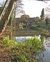
The North Walsham and Dilham Canal is a waterway in the English
county of Norfolk
. It is accepted officially that this waterway is the only canal in Norfolk although it is the canalization of the upper reaches of the River Ant
. This navigation was constructed with locks a little wider than most canals in the UK to accommodate the use of the Norfolk wherries
. It is 8.7 miles (14 km) long and runs from Swafield
Bridge to a junction with the River Ant
at Smallburgh
.
and Dilham
, who feared that their businesses would collapse if boats could reach North Walsham
, but the navigation was nevertheless authorised by an Act of Parliament
dated 5 May 1812, which created the Company of Proprietors of the North Walsham and Dilham Canal Navigation. They had powers to raise £30,000 by the issuing of shares, and a further £10,000 if required, either from shares or by mortgage. Work on the canalisation of the River Ant did not start until 1825, with some of the delays caused by a claim for damages made by Issac Harris Lewis, who owned his own staithe
at Dilham and felt that the new canal would damage his trade. His case was heard in April 1825 and he was awarded £1,500 in compensation. Work began in the same month, employing 100 men from Bedfordshire
.
The canal was designed by John Millington, who acted as engineer for the project, although the actual construction was carried out by Thomas Hughes, who had previously worked on the construction of the Caledonian Canal
, the Dingwall Canal
and the Union Canal
, all in Scotland
. Millington came from Hammersmith
in London
. The North Walsham and Dilham Canal was his only canal-building venture. Later in his career he went to the United States of America and wrote Elements of Civil Engineering which includes much information on canal building.
The design of the canal included six locks
to raise the level by 58 feet (17.7 m) along its 8.2 miles (13.2 km) length. The locks were sized for wherries
, which were 50 by. Vessels were able to reach Cubbitt's Mill by 14 June 1826 and the canal was formally opened on 29 August 1826. The water supply for the canal came from the ponds at Antingham
, but the link into the ponds could only be used by small lighters, as it was not deep enough to be used by wherries. Consequently, they used a basin next to Antingham Mills. Tolls on all cargoes using the canal were collected at Tonnage Bridge, where there was once a wharf and a cottage.
to the two Antingham Bone Mills, although other cargoes were carried such as manure
, flour
, grain, coal
and farm produce. A profitable trade in coal did not develop, as the tolls were too high and it was cheaper for coal to be brought down the coast from the north east and landed on the beach near Bacton
or Mundesley
, from where it would reach North Walsham by cart. Later, the railways handled most of the coal traffic. Most of the vessels using the canal were wherries, which had a draught
of 3 foot (0.9144 m) and were capable of carrying between 18 and 20 tons
. Some wherries were of a slip-keel design, where the keel
of a loaded boat could be unbolted from the bottom of the vessel while it was afloat, in order to negotiate the shallow waters of the canal. Once unloaded, the keel would be replaced, to allow more sail to be used. While detached, the keels were towed behind the boat, to prevent them from drying out and warping. A smaller 12-ton wherry regularly carried vegetables between Antingham and Great Yarmouth
and was known as the cabbage wherry.
In 1887, Walter Rye was appointed as the clerk and noticed a number of irreguarities in the way the company ran. Edward Press was the general manager, although he was disqualified from the post as he profited from the canal, and there was no treasurer, despite the fact that the enabling act required one to be appointed. There was also no way to wind up the company. Rye's concerns were ignored, as nothing changed, and Press continued to run the canal. In 1893, the upper 1.4 miles (2.3 km) from Swafield lock to Antingham were abandoned, but traffic figures for 1898 show that 6,386 tons arrived at wharves on the canal, 5,000 tons were loaded for shipping, and 400 tons were carried within the confines of the canal. Trade declined steadily and Press died on 2 July 1906. A director of the General Estates Company bought the canal at an auction held on 11 September 1907, for £2,550.
Heavy flooding in August 1912 washed away several staithes
, and resulted in a breach of the canal bank above Bacton Wood Lock. The canal was bought by G Cubitt and G Walker in 1921, who immediately formed the North Walsham Canal Co Ltd, which bought the canal for the £1,500 they had paid. Some attempts were made to dredge the channel below Swafield locks in the 1920s, but the section above Swafield Bridge was abandoned in 1927 and has reverted to farmland. The wherry
"Ella" made the final trading journey on the canal from Bacton Staithe in 1934.
The canal is only navigable for the first 2 miles (3.2 km) from the Smallburgh
end, up to Honing lock. There are moves to restore the canal and at present there is work going on to restore the bottom lock. The East Anglian Waterways Association
has undertaken a detailed environmental survey of the canal and engineering studies on lock restoration and other technical matters and with help from the North Walsham and Dilham Canal Trust, has held regular work parties at Honing, Briggate and Ebridge Locks, to clear encroaching trees. Further north, both Bradfield Bridge and the bridge that carries Anchor Road over the canal at Bacton Wood Mill are grade II listed structures.
Some 2.25 miles (3.6 km) of the route, consisting of the pound above Bacton Wood lock, the lock itself, the pound below it and Ebridge Lock, were sold to the Old Canal Company in 2009, who intend to re-water this section. Work has concentrated on the lock at Bacton Mill, where reinstated water levels will enable the mill (which has been restored by its owner) to operate once more.
The residents of North Walsham made ten mosaics for the Millennium celebrations, one of which shows a Norfolk wherry.
England
England is a country that is part of the United Kingdom. It shares land borders with Scotland to the north and Wales to the west; the Irish Sea is to the north west, the Celtic Sea to the south west, with the North Sea to the east and the English Channel to the south separating it from continental...
county of Norfolk
Norfolk
Norfolk is a low-lying county in the East of England. It has borders with Lincolnshire to the west, Cambridgeshire to the west and southwest and Suffolk to the south. Its northern and eastern boundaries are the North Sea coast and to the north-west the county is bordered by The Wash. The county...
. It is accepted officially that this waterway is the only canal in Norfolk although it is the canalization of the upper reaches of the River Ant
River Ant
The River Ant is a tributary river of the River Bure in the county of Norfolk, England. It is 17 miles long , and has an overall drop of 25 metres from source to mouth...
. This navigation was constructed with locks a little wider than most canals in the UK to accommodate the use of the Norfolk wherries
Norfolk wherry
The Norfolk wherry is a type of boat on The Broads in Norfolk, England. Three main types were developed over its life, all featuring the distinctive gaff rig with a single, high-peaked sail and the mast stepped well forward.-Development of the wherry:...
. It is 8.7 miles (14 km) long and runs from Swafield
Swafield
Swafield is a village and a civil parish in the English county of Norfolk. The village is north north east of Norwich, south south East of Cromer and north-east of London. The village lies north of the town of North Walsham. The village sits astride the B1145 Kings Lynn to Mundesley road that...
Bridge to a junction with the River Ant
River Ant
The River Ant is a tributary river of the River Bure in the county of Norfolk, England. It is 17 miles long , and has an overall drop of 25 metres from source to mouth...
at Smallburgh
Smallburgh
Smallburgh is a village and a civil parish in the English county of Norfolk. The village is fourteen miles south-east of Cromer, fourteen miles north-east of Norwich and north-east of London. The village lies five miles south-east of the nearby town of North Walsham...
.
History
The River Ant was navigable to Dilham prior to 1810, when consideration was given to extending navigation northwards along the course of the river. Plans were drawn up by William Youard and John Millington in 1811 and it was Millington's plan that formed the basis of a bill presented to Parliament in early 1812. It was opposed by the inhabitants of WorsteadWorstead
Worstead is a village and civil parish in the English county of Norfolk. It lies 5 km south of North Walsham, 9 km north of Wroxham, and 20 km north of Norwich. The village is served by Worstead railway station on the Bittern Line....
and Dilham
Dilham
Dilham is a village and civil parish covering an area of with a population of 301 in 128 homes as of the 2001 census. It is on the River Ant just of the A149 road, near Stalham in Norfolk, England within The Broads...
, who feared that their businesses would collapse if boats could reach North Walsham
North Walsham
North Walsham is a market town and civil parish in Norfolk, England in the North Norfolk district.-Demographics:The civil parish has an area of and in the 2001 census had a population of 11,998. For the purposes of local government, the parish falls within the district of North...
, but the navigation was nevertheless authorised by an Act of Parliament
Act of Parliament
An Act of Parliament is a statute enacted as primary legislation by a national or sub-national parliament. In the Republic of Ireland the term Act of the Oireachtas is used, and in the United States the term Act of Congress is used.In Commonwealth countries, the term is used both in a narrow...
dated 5 May 1812, which created the Company of Proprietors of the North Walsham and Dilham Canal Navigation. They had powers to raise £30,000 by the issuing of shares, and a further £10,000 if required, either from shares or by mortgage. Work on the canalisation of the River Ant did not start until 1825, with some of the delays caused by a claim for damages made by Issac Harris Lewis, who owned his own staithe
Wharf
A wharf or quay is a structure on the shore of a harbor where ships may dock to load and unload cargo or passengers.Such a structure includes one or more berths , and may also include piers, warehouses, or other facilities necessary for handling the ships.A wharf commonly comprises a fixed...
at Dilham and felt that the new canal would damage his trade. His case was heard in April 1825 and he was awarded £1,500 in compensation. Work began in the same month, employing 100 men from Bedfordshire
Bedfordshire
Bedfordshire is a ceremonial county of historic origin in England that forms part of the East of England region.It borders Cambridgeshire to the north-east, Northamptonshire to the north, Buckinghamshire to the west and Hertfordshire to the south-east....
.
The canal was designed by John Millington, who acted as engineer for the project, although the actual construction was carried out by Thomas Hughes, who had previously worked on the construction of the Caledonian Canal
Caledonian Canal
The Caledonian Canal is a canal in Scotland that connects the Scottish east coast at Inverness with the west coast at Corpach near Fort William. It was constructed in the early nineteenth century by engineer Thomas Telford, and is a sister canal of the Göta Canal in Sweden, also constructed by...
, the Dingwall Canal
Dingwall Canal
The Dingwall Canal was a short tidal canal running from the town of Dingwall to the Cromarty Firth in the county of Ross and Cromarty, Scotland...
and the Union Canal
Union Canal (Scotland)
The Union Canal is a 31.5-mile canal in Scotland, from Lochrin Basin, Fountainbridge, Edinburgh to Falkirk, where it meets the Forth and Clyde Canal.-Location and features:...
, all in Scotland
Scotland
Scotland is a country that is part of the United Kingdom. Occupying the northern third of the island of Great Britain, it shares a border with England to the south and is bounded by the North Sea to the east, the Atlantic Ocean to the north and west, and the North Channel and Irish Sea to the...
. Millington came from Hammersmith
Hammersmith
Hammersmith is an urban centre in the London Borough of Hammersmith and Fulham in west London, England, in the United Kingdom, approximately five miles west of Charing Cross on the north bank of the River Thames...
in London
London
London is the capital city of :England and the :United Kingdom, the largest metropolitan area in the United Kingdom, and the largest urban zone in the European Union by most measures. Located on the River Thames, London has been a major settlement for two millennia, its history going back to its...
. The North Walsham and Dilham Canal was his only canal-building venture. Later in his career he went to the United States of America and wrote Elements of Civil Engineering which includes much information on canal building.
The design of the canal included six locks
Lock (water transport)
A lock is a device for raising and lowering boats between stretches of water of different levels on river and canal waterways. The distinguishing feature of a lock is a fixed chamber in which the water level can be varied; whereas in a caisson lock, a boat lift, or on a canal inclined plane, it is...
to raise the level by 58 feet (17.7 m) along its 8.2 miles (13.2 km) length. The locks were sized for wherries
Norfolk wherry
The Norfolk wherry is a type of boat on The Broads in Norfolk, England. Three main types were developed over its life, all featuring the distinctive gaff rig with a single, high-peaked sail and the mast stepped well forward.-Development of the wherry:...
, which were 50 by. Vessels were able to reach Cubbitt's Mill by 14 June 1826 and the canal was formally opened on 29 August 1826. The water supply for the canal came from the ponds at Antingham
Antingham
Antingham is a village and civil parish in the north of the English county of Norfolk. The village is located about south of Cromer and north of North Walsham...
, but the link into the ponds could only be used by small lighters, as it was not deep enough to be used by wherries. Consequently, they used a basin next to Antingham Mills. Tolls on all cargoes using the canal were collected at Tonnage Bridge, where there was once a wharf and a cottage.
Operation
The main use of the canal was to carry offalOffal
Offal , also called, especially in the United States, variety meats or organ meats, refers to the internal organs and entrails of a butchered animal. The word does not refer to a particular list of edible organs, which varies by culture and region, but includes most internal organs other than...
to the two Antingham Bone Mills, although other cargoes were carried such as manure
Manure
Manure is organic matter used as organic fertilizer in agriculture. Manures contribute to the fertility of the soil by adding organic matter and nutrients, such as nitrogen, that are trapped by bacteria in the soil...
, flour
Flour
Flour is a powder which is made by grinding cereal grains, other seeds or roots . It is the main ingredient of bread, which is a staple food for many cultures, making the availability of adequate supplies of flour a major economic and political issue at various times throughout history...
, grain, coal
Coal
Coal is a combustible black or brownish-black sedimentary rock usually occurring in rock strata in layers or veins called coal beds or coal seams. The harder forms, such as anthracite coal, can be regarded as metamorphic rock because of later exposure to elevated temperature and pressure...
and farm produce. A profitable trade in coal did not develop, as the tolls were too high and it was cheaper for coal to be brought down the coast from the north east and landed on the beach near Bacton
Bacton
Bacton may refer to:* Bacton, Herefordshire* Bacton, Norfolk* Bacton, Suffolk...
or Mundesley
Mundesley
Mundesley is a coastal village and a civil parish in the English county of Norfolk. The village is 20.3 miles north-north east of Norwich, 7.3 miles south east of Cromer and 136 miles north east of London. The village lies 5.6 miles north-north east of the town of North Walsham. The nearest...
, from where it would reach North Walsham by cart. Later, the railways handled most of the coal traffic. Most of the vessels using the canal were wherries, which had a draught
Draft (hull)
The draft of a ship's hull is the vertical distance between the waterline and the bottom of the hull , with the thickness of the hull included; in the case of not being included the draft outline would be obtained...
of 3 foot (0.9144 m) and were capable of carrying between 18 and 20 tons
Tons
Tons can refer to:* Tons River, a major river in India* the plural of ton, a unit of mass, force, volume, energy or power* short ton, 2,000 pounds, used in the United States...
. Some wherries were of a slip-keel design, where the keel
Keel
In boats and ships, keel can refer to either of two parts: a structural element, or a hydrodynamic element. These parts overlap. As the laying down of the keel is the initial step in construction of a ship, in British and American shipbuilding traditions the construction is dated from this event...
of a loaded boat could be unbolted from the bottom of the vessel while it was afloat, in order to negotiate the shallow waters of the canal. Once unloaded, the keel would be replaced, to allow more sail to be used. While detached, the keels were towed behind the boat, to prevent them from drying out and warping. A smaller 12-ton wherry regularly carried vegetables between Antingham and Great Yarmouth
Great Yarmouth
Great Yarmouth, often known to locals as Yarmouth, is a coastal town in Norfolk, England. It is at the mouth of the River Yare, east of Norwich.It has been a seaside resort since 1760, and is the gateway from the Norfolk Broads to the sea...
and was known as the cabbage wherry.
Decline
The canal was not a financial success, and in 1866 the company obtained an act of Parliament that would allow them to sell the canal providing three-quarters of the shareholders agreed. In 1885, they decided to use this power, as Edward Press, the owner of Bacton Wood mill, and a trader with a fleet of wherries, wished to purchase it. The sale was completed on 16 March 1886, on the understanding that the £600 price would be distributed to the shareholders. Holders of 446 of the original 586 shares were traced, but after paying money on 55 shares, James Turner, the London solicitor handling the sale, absconded with the rest of the fund. The proprietors felt morally bound to refund the money themselves, but did not do so immediately, as none of the shareholders made a claim. Eventually in 1896, five of them, including Press who had bought the canal, contributed £110 17s 7d (£110.88) to a fund which was distributed as a dividend to those who had not been paid.In 1887, Walter Rye was appointed as the clerk and noticed a number of irreguarities in the way the company ran. Edward Press was the general manager, although he was disqualified from the post as he profited from the canal, and there was no treasurer, despite the fact that the enabling act required one to be appointed. There was also no way to wind up the company. Rye's concerns were ignored, as nothing changed, and Press continued to run the canal. In 1893, the upper 1.4 miles (2.3 km) from Swafield lock to Antingham were abandoned, but traffic figures for 1898 show that 6,386 tons arrived at wharves on the canal, 5,000 tons were loaded for shipping, and 400 tons were carried within the confines of the canal. Trade declined steadily and Press died on 2 July 1906. A director of the General Estates Company bought the canal at an auction held on 11 September 1907, for £2,550.
Heavy flooding in August 1912 washed away several staithes
Wharf
A wharf or quay is a structure on the shore of a harbor where ships may dock to load and unload cargo or passengers.Such a structure includes one or more berths , and may also include piers, warehouses, or other facilities necessary for handling the ships.A wharf commonly comprises a fixed...
, and resulted in a breach of the canal bank above Bacton Wood Lock. The canal was bought by G Cubitt and G Walker in 1921, who immediately formed the North Walsham Canal Co Ltd, which bought the canal for the £1,500 they had paid. Some attempts were made to dredge the channel below Swafield locks in the 1920s, but the section above Swafield Bridge was abandoned in 1927 and has reverted to farmland. The wherry
Wherry
A wherry is a type of boat that was traditionally used for carrying cargo or passengers on rivers and canals in England, and is particularly associated with the River Thames and also with the Broadland rivers of Norfolk and Suffolk. London passenger wherries evolved into the Thames skiff, a...
"Ella" made the final trading journey on the canal from Bacton Staithe in 1934.
The canal today
The canal was never nationalized and continued to belong to the North Walsham Canal Company.The canal is only navigable for the first 2 miles (3.2 km) from the Smallburgh
Smallburgh
Smallburgh is a village and a civil parish in the English county of Norfolk. The village is fourteen miles south-east of Cromer, fourteen miles north-east of Norwich and north-east of London. The village lies five miles south-east of the nearby town of North Walsham...
end, up to Honing lock. There are moves to restore the canal and at present there is work going on to restore the bottom lock. The East Anglian Waterways Association
East Anglian Waterways Association
The East Anglian Waterways Association is a waterway society and an umbrella organisation in East Anglia, England, UK.The association was founded on 18 April 1958, and it campaigns for the preservation, restoration and good management of the tidal and inland waterways in East Anglia...
has undertaken a detailed environmental survey of the canal and engineering studies on lock restoration and other technical matters and with help from the North Walsham and Dilham Canal Trust, has held regular work parties at Honing, Briggate and Ebridge Locks, to clear encroaching trees. Further north, both Bradfield Bridge and the bridge that carries Anchor Road over the canal at Bacton Wood Mill are grade II listed structures.
Some 2.25 miles (3.6 km) of the route, consisting of the pound above Bacton Wood lock, the lock itself, the pound below it and Ebridge Lock, were sold to the Old Canal Company in 2009, who intend to re-water this section. Work has concentrated on the lock at Bacton Mill, where reinstated water levels will enable the mill (which has been restored by its owner) to operate once more.
The residents of North Walsham made ten mosaics for the Millennium celebrations, one of which shows a Norfolk wherry.
Locks and Watermills
See also
- Canals of the United KingdomCanals of the United KingdomThe canals of the United Kingdom are a major part of the network of inland waterways in the United Kingdom. They have a colourful history, from use for irrigation and transport, through becoming the focus of the Industrial Revolution, to today's role for recreational boating...
- History of the British canal systemHistory of the British canal systemThe British canal system of water transport played a vital role in the United Kingdom's Industrial Revolution at a time when roads were only just emerging from the medieval mud and long trains of pack horses were the only means of "mass" transit by road of raw materials and finished products The...