

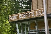
Point Roberts, Washington
Encyclopedia
Point Roberts is an unincorporated community
in Whatcom County, Washington
, United States
. It has a post office
, with the ZIP code
of 98281, whose ZIP Code Tabulation Area
(ZCTA) had a population of 1,314 at the 2010 census.
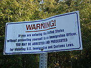
A geopolitical oddity, Point Roberts is a part of the United States (that is not an island
) that is not physically connected to it, making it a pene-exclave of the U.S. It is located on the southernmost tip of the Tsawwassen Peninsula, south of Delta, British Columbia
, Canada
, and can be reached by land from the rest of the United States only by traveling through Canada. It can be reached directly from the rest of Washington and the U.S. by crossing Boundary Bay
by sea or air.
ans to see Point Roberts were members of the 1791 expedition of Francisco de Eliza
. The maps produced as a result of Eliza's explorations depicted Point Roberts as "Isla de Cepeda" or "Isla de Zepeda" In 1792 the British expedition of George Vancouver
and the Spanish expedition of Dionisio Alcalá Galiano
encountered one another near Point Roberts. In the morning of June 13, 1792, the two ships under Galiano sailed into Boundary Bay and verified that Point Roberts was not an island, which was thus renamed Punta Cepeda. They then sailed around Point Roberts and immediately encountered the HMS Chatham
, the second ship of Vancouver's expedition. The two parties made contact and soon agreed to share information and work together in mapping the Strait of Georgia
. Point Roberts acquired its present name from George Vancouver, who named it after his friend Henry Roberts
, who had originally been given command of the expedition. Point Roberts assumed its present political status in 1846, when the Oregon Treaty
extended the 49th parallel
as the boundary between American and British
territory from the Rocky Mountains
to Georgia Strait.
known as the Oregon Country
to the Americans, and as the Columbia District
to the British, American expansionists like U.S. Senator Edward A. Hannegan
of Indiana urged U.S. President
James K. Polk
to annex the entire Oregon Country up to latitude 54°40′N, as the Democrats had been elected on the slogan "Fifty-Four Forty or Fight".
While his government asserted that the title of America to the entire territory was unquestionable even though there was only one American resident north of the Columbia basin (who was an ex-Briton), Polk and his secretary James Buchanan
made an aggressive counter-offer of a boundary at 49 degrees
with the line straight across Vancouver Island
, with no commercial privilege to be granted to the British south of the line, with the exception of free ports on Vancouver Island
. This offer was rejected by the British and withdrawn by the U.S. shortly thereafter.
On April 18, 1846, notice was forwarded to London
that the U.S. Congress had adopted a joint resolution abrogating the Treaty of 1818
which provided for joint occupancy.
The British emissary, Richard Pakenham, had previously been advised that the last concession which could be expected of America was in bending the boundary at the 49th parallel
around the lower end of Vancouver Island
. Fort Victoria
was viewed as the future center for settlements on the island. It was deemed necessary around this point in time to give up territory on the Lower Mainland
to keep Vancouver Island part of British North America
.
Lord Aberdeen
, British Foreign Secretary, proposed a treaty making the 49th parallel the boundary to the sea, giving Great Britain
the whole of Vancouver Island. The Treaty of Oregon
was concluded on June 15, 1846.
The acceptance of the 49th parallel as the international boundary was concluded without precise knowledge of the effects that it would ultimately have. Later, as the Boundary Commission was surveying the line, the British government realized that the peninsula of Point Roberts would be an isolated part of the United States. The British Foreign Office
instructed Captain James Prevost, the British Boundary Commissioner, to inform his American counterpart of the situation and request that Point Roberts be left to Britain, because of the great inconvenience it would be to the United States. If the American Boundary Commission was reluctant, Prevost was instructed to offer "some equivalent compensation by a slight alteration of the Line of Boundary on the Mainland". It is not known how the American commissioner responded, but Point Roberts became part of the United States.
In 1949, there was talk about Point Roberts seceding from the U.S.A. and joining Canada, but this never happened. In 1973 a drought caused the wells to run dry and created tensions between the American and Canadian residents of Point Roberts. The Americans threatened to cut off the Canadian residents' water supply — and hung up signs saying "Canadians Go Home" — unless the Canadian district of Delta agreed to provide water to Point Roberts, an arrangement that became permanent in 1986. Delta Fire Department also provides assistance to the Point Roberts volunteer fire department when requested, and until 1988 BC Tel (now Telus
) provided telephone service.
bordered by Canada and the waters of Boundary Bay
. It is 22 miles (35.4 km) south of Downtown Vancouver
, British Columbia
. Point Roberts is part of the U.S. because it lies south of the 49th parallel
, which constitutes the Canada-U.S. border
in that area.
(Other exclaves of this type include the U.S. state of Alaska
, and parts of Minnesota
such as the Northwest Angle
, Elm Point, Minnesota
and Province Point, Vermont. Alburgh, Vermont is also separated by land from the rest of the United States but can be reached by highways originating in the United States.)
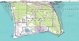
Point Roberts borders the municipality of Delta
in British Columbia
. Boundary Bay
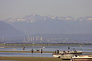
lies to the east of Point Roberts and the Strait of Georgia
to the south and west. The peninsula is about 2 miles (3 km) from north to south and about 3 miles (5 km) from east to west. It has an area of 4.884 square miles (12.6 km²).
of 2000, there were 1,308 people, 607 households, and 373 families residing in the ZCTA. There were 1,820 housing units, only 607 of which were occupied. The racial makeup of the ZCTA was 94.9% White
, 0.6% African American
, 0.8% Native American
, 2.0% Asian
, 0.1% Pacific Islander
, 0.5% from other races, and 1.1% from two or more races. Hispanics or Latinos
of any race were 1.3% of the population.
The age distribution was 20.9% under 18, 3.4% from 18 to 24, 29.0% from 25 to 44, 32.0% from 45 to 64, and 14.7% who were 65 or older. The median age was 43.2 years.
The median income for a household in the ZCTA was $36,146; the median income for a family was $45,417; and the per capita income
was $25,449.
During the summer the population swells to about 4500, most of the visitors being vacationing Canadians.


. After the September 11 attacks, increased scrutiny at the United States' borders evoked worry that the passage of school buses would be rendered infeasible by long traffic delays at the border crossing, but an arrangement was made to give the school buses expedited passage.
and a large marina
for air and water access.
, especially those in search of cheaper gasoline
. Point Roberts is the only part of the US where gasoline is sold by the liter. The handful of area bars and nightclubs are popular with visiting Canadians despite a drinking age of 21 in the state of Washington versus that of 19 in British Columbia, although this popularity diminished somewhat after Sunday drinking was legalized in British Columbia
. The local post office rents hundreds of post office box
es to individuals and businesses from the Greater Vancouver area (including the U.S. Consulate in Vancouver), who find it a convenient and fast way to receive mail and parcels from the United States without paying for cross-border shipping costs.
There is no hospital, doctor, dentist, pharmacist, or veterinarian, and because American health insurers will not pay for treatment given by Canadian providers, Point Roberts citizens usually seek even emergency medical care in Bellingham, Washington
, although Vancouver is closer.
Residents enjoy a low crime rate at the cost of a high local security presence. Because of having to go through the international border twice to get to the rest of the U.S.A., some have called it "the best gated community in the U.S."
created by Vancouver Island
, the north shore mountains surrounding Vancouver
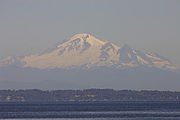
, and the North Cascades (including Mount Baker
). This micro-climate provides some of the mildest weather in the Pacific Northwest
. With annual precipitation of about 1000 mm (40 inches), Point Roberts enjoys more sunny days and a milder climate than its neighbors.
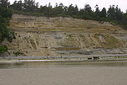 Beneath Point Roberts, the bedrock of the Chuckanut Formation
was deposited as an alluvial plain containing layers of sediments consisting of silt, sand, sand and gravel, and peat. During the last 60 million years the sediments were compacted and folded by mountain building forces resulting from continental drift to form strata of siltstone, sandstone, conglomerate and coal. During recent geologic history, the Chuckanut formation was overridden by four or more glaciations.
Point Roberts consists of a series of the resulting glacial sediments resting upon the Chuckanut Formation. The lowest glacial sediments (now near sea level) are from Salmon Springs or older glaciations. At the peak of the most recent glaciation, the main ice sheet was in excess of 7,000 feet thick as it moved southward between Vancouver Island and the Canadian Coast Range and down the Strait of Georgia. A smaller lobe of the continental glacier in excess of 5,000 feet traveled down the Fraser River flood plains merging with the main ice sheet over the greater Vancouver area and Whatcom and Skagit Counties. The coalesced continental ice sheet traveled south terminating in the vicinity of Chehalis, Washington
. Relatively impermeable Vashon glacial lodgment till (estimated to be as much as 40 feet thick at the uppermost layer) was plastered over the advance outwash as the weight of the 7,000 foot thick plus Strait of Georgia ice lobe moved southward over approximately 10,000 years. (Armstrong, et. all, 1965) Point Roberts, Tsawwassen, and part of British Columbia extending past English Bluff actually comprised an island at the close of the Vashon glaciation, approximately 11,000 years ago.
As the ice sheets melted, the thinner Fraser Lobe began to float while the Strait of Georgia lobe acted as a dam forming a lake under the Fraser Lobe. Sediments settling from the melting, floating ice resulted in the accumulation of 300 feet or more of Glacial Marine Drift over much of western Whatcom County. (Easterbrook, 1976; Geologic Map of Western Whatcom County, Washington, USGS, Map I-854-B) This Glacial Marine Drift is generally soft and was not consolidated by the weight of the glacier. A discontinuous, thin mantle of this Glacial Marine Drift above the Glacial Lodgment Till has been identified sporadically across Point Roberts. The uppermost layer of glacial sediments consists of recessional sand, silt, and gravel deposited as the Strait of Georgia ice lobe receded. Since the recession of the glaciers, the Fraser River has deposited deltaic sediments on the north and easterly side of the Point Roberts-Tsawwassen Island connecting it to the Greater Vancouver mainland (approximately 2,500 years ago, Murray 2008). At some locations, these sediments have been eroded or removed exposing the lodgment till.

's area code 604 and served by BCTel
, a Canadian telephone company. Today, Point Roberts phone numbers are in area code 360
and exchange
945, and the local regular-service telecom provider is Whidbey Telecom
. Cable television in Point Roberts is served by Delta Cable, a subsidiary of Canadian cable company EastLink
.
Being adjacent to Metro Vancouver, residents receive the same over-the-air TV and radio broadcasts available in the Metro Vancouver region. Delta Cable offers most major television channels from Vancouver, as well as some stations from Seattle
, whose television market includes Point Roberts, as well as Bellingham; Delta Cable also offers a selection of popular American cable networks, but no digital cable service or Canadian specialty channels.
Both Whidbey Telecom and Delta Cable provide broadband Internet access
to residents of Point Roberts. Mobile telephone service is provided by a variety of companies, both American and Canadian.
Unincorporated area
In law, an unincorporated area is a region of land that is not a part of any municipality.To "incorporate" in this context means to form a municipal corporation, a city, town, or village with its own government. An unincorporated community is usually not subject to or taxed by a municipal government...
in Whatcom County, Washington
Whatcom County, Washington
Whatcom County is a county located in the U.S. state of Washington. Its name ultimately derives from the Lummi word Xwotʼqom, meaning "noisy water." As of 2010, the population was 201,140. The county seat is at Bellingham, which is also the county's largest city...
, United States
United States
The United States of America is a federal constitutional republic comprising fifty states and a federal district...
. It has a post office
Post office
A post office is a facility forming part of a postal system for the posting, receipt, sorting, handling, transmission or delivery of mail.Post offices offer mail-related services such as post office boxes, postage and packaging supplies...
, with the ZIP code
ZIP Code
ZIP codes are a system of postal codes used by the United States Postal Service since 1963. The term ZIP, an acronym for Zone Improvement Plan, is properly written in capital letters and was chosen to suggest that the mail travels more efficiently, and therefore more quickly, when senders use the...
of 98281, whose ZIP Code Tabulation Area
ZIP Code Tabulation Area
ZIP Code Tabulation Areas are statistical entities developed by the United States Census Bureau for tabulating summary statistics from Census 2000. This new entity was developed to overcome the difficulties in precisely defining the land area covered by each ZIP code...
(ZCTA) had a population of 1,314 at the 2010 census.
A geopolitical oddity, Point Roberts is a part of the United States (that is not an island
Island
An island or isle is any piece of sub-continental land that is surrounded by water. Very small islands such as emergent land features on atolls can be called islets, cays or keys. An island in a river or lake may be called an eyot , or holm...
) that is not physically connected to it, making it a pene-exclave of the U.S. It is located on the southernmost tip of the Tsawwassen Peninsula, south of Delta, British Columbia
Delta, British Columbia
Delta is a district municipality in British Columbia, and forms part of Metro Vancouver. Located south of Richmond, it is bordered by the Fraser River to the north, the United States to the south and the city of Surrey to the east...
, Canada
Canada
Canada is a North American country consisting of ten provinces and three territories. Located in the northern part of the continent, it extends from the Atlantic Ocean in the east to the Pacific Ocean in the west, and northward into the Arctic Ocean...
, and can be reached by land from the rest of the United States only by traveling through Canada. It can be reached directly from the rest of Washington and the U.S. by crossing Boundary Bay
Boundary Bay
Boundary Bay is situated on the Pacific coast of North America on the border between the Canadian province of British Columbia and the U.S. state of Washington....
by sea or air.
History
The first EuropeEurope
Europe is, by convention, one of the world's seven continents. Comprising the westernmost peninsula of Eurasia, Europe is generally 'divided' from Asia to its east by the watershed divides of the Ural and Caucasus Mountains, the Ural River, the Caspian and Black Seas, and the waterways connecting...
ans to see Point Roberts were members of the 1791 expedition of Francisco de Eliza
Francisco de Eliza
Francisco de Eliza y Reventa was a Spanish naval officer, navigator, and explorer. He is remembered mainly for his work in the Pacific Northwest...
. The maps produced as a result of Eliza's explorations depicted Point Roberts as "Isla de Cepeda" or "Isla de Zepeda" In 1792 the British expedition of George Vancouver
George Vancouver
Captain George Vancouver RN was an English officer of the British Royal Navy, best known for his 1791-95 expedition, which explored and charted North America's northwestern Pacific Coast regions, including the coasts of contemporary Alaska, British Columbia, Washington and Oregon...
and the Spanish expedition of Dionisio Alcalá Galiano
Dionisio Alcalá Galiano
Dionisio Alcalá Galiano was a Spanish naval officer, cartographer, and explorer. He mapped various coastlines in Europe and the Americas with unprecedented accuracy, using new technology such as chronometers...
encountered one another near Point Roberts. In the morning of June 13, 1792, the two ships under Galiano sailed into Boundary Bay and verified that Point Roberts was not an island, which was thus renamed Punta Cepeda. They then sailed around Point Roberts and immediately encountered the HMS Chatham
HMS Chatham (1788)
HMS Chatham was a Royal Navy survey brig that accompanied HMS Discovery on George Vancouver's exploration of the west coast of North America in his 1791–1795 expedition. Chatham was built by King, of Dover and launched in early 1788...
, the second ship of Vancouver's expedition. The two parties made contact and soon agreed to share information and work together in mapping the Strait of Georgia
Strait of Georgia
The Strait of Georgia or the Georgia Strait is a strait between Vancouver Island and the mainland coast of British Columbia, Canada. It is approximately long and varies in width from...
. Point Roberts acquired its present name from George Vancouver, who named it after his friend Henry Roberts
Henry Roberts (captain)
Henry Roberts was an officer in the Royal Navy who served with Captain Cook on his last two voyages.Roberts served as lieutenant on Cook's HMS Discovery, where he was entrusted with many hydrographic and cartographic tasks, and also met then-midshipman George Vancouver...
, who had originally been given command of the expedition. Point Roberts assumed its present political status in 1846, when the Oregon Treaty
Oregon Treaty
The Oregon Treaty is a treaty between the United Kingdom and the United States that was signed on June 15, 1846, in Washington, D.C. The treaty brought an end to the Oregon boundary dispute by settling competing American and British claims to the Oregon Country, which had been jointly occupied by...
extended the 49th parallel
49th parallel north
The 49th parallel north is a circle of latitude that is 49 degrees north of the Earth's equatorial plane. It crosses Europe, Asia, the Pacific Ocean, North America, and the Atlantic Ocean....
as the boundary between American and British
United Kingdom
The United Kingdom of Great Britain and Northern IrelandIn the United Kingdom and Dependencies, other languages have been officially recognised as legitimate autochthonous languages under the European Charter for Regional or Minority Languages...
territory from the Rocky Mountains
Rocky Mountains
The Rocky Mountains are a major mountain range in western North America. The Rocky Mountains stretch more than from the northernmost part of British Columbia, in western Canada, to New Mexico, in the southwestern United States...
to Georgia Strait.
Treaty history specific to Point Roberts
After years of joint occupation of the disputed area between Mexican California and Russian AmericaAlaska
Alaska is the largest state in the United States by area. It is situated in the northwest extremity of the North American continent, with Canada to the east, the Arctic Ocean to the north, and the Pacific Ocean to the west and south, with Russia further west across the Bering Strait...
known as the Oregon Country
Oregon Country
The Oregon Country was a predominantly American term referring to a disputed ownership region of the Pacific Northwest of North America. The region was occupied by British and French Canadian fur traders from before 1810, and American settlers from the mid-1830s, with its coastal areas north from...
to the Americans, and as the Columbia District
Columbia District
The Columbia District was a fur trading district in the Pacific Northwest region of British North America in the 19th century. It was explored by the North West Company between 1793 and 1811, and established as an operating fur district around 1810...
to the British, American expansionists like U.S. Senator Edward A. Hannegan
Edward A. Hannegan
Edward Allen Hannegan was a United States Representative and Senator from Indiana.-Early life and education:...
of Indiana urged U.S. President
President of the United States
The President of the United States of America is the head of state and head of government of the United States. The president leads the executive branch of the federal government and is the commander-in-chief of the United States Armed Forces....
James K. Polk
James K. Polk
James Knox Polk was the 11th President of the United States . Polk was born in Mecklenburg County, North Carolina. He later lived in and represented Tennessee. A Democrat, Polk served as the 17th Speaker of the House of Representatives and the 12th Governor of Tennessee...
to annex the entire Oregon Country up to latitude 54°40′N, as the Democrats had been elected on the slogan "Fifty-Four Forty or Fight".
While his government asserted that the title of America to the entire territory was unquestionable even though there was only one American resident north of the Columbia basin (who was an ex-Briton), Polk and his secretary James Buchanan
James Buchanan
James Buchanan, Jr. was the 15th President of the United States . He is the only president from Pennsylvania, the only president who remained a lifelong bachelor and the last to be born in the 18th century....
made an aggressive counter-offer of a boundary at 49 degrees
49th parallel north
The 49th parallel north is a circle of latitude that is 49 degrees north of the Earth's equatorial plane. It crosses Europe, Asia, the Pacific Ocean, North America, and the Atlantic Ocean....
with the line straight across Vancouver Island
Vancouver Island
Vancouver Island is a large island in British Columbia, Canada. It is one of several North American locations named after George Vancouver, the British Royal Navy officer who explored the Pacific Northwest coast of North America between 1791 and 1794...
, with no commercial privilege to be granted to the British south of the line, with the exception of free ports on Vancouver Island
Vancouver Island
Vancouver Island is a large island in British Columbia, Canada. It is one of several North American locations named after George Vancouver, the British Royal Navy officer who explored the Pacific Northwest coast of North America between 1791 and 1794...
. This offer was rejected by the British and withdrawn by the U.S. shortly thereafter.
On April 18, 1846, notice was forwarded to London
London
London is the capital city of :England and the :United Kingdom, the largest metropolitan area in the United Kingdom, and the largest urban zone in the European Union by most measures. Located on the River Thames, London has been a major settlement for two millennia, its history going back to its...
that the U.S. Congress had adopted a joint resolution abrogating the Treaty of 1818
Treaty of 1818
The Convention respecting fisheries, boundary and the restoration of slaves between the United States of America and the United Kingdom of Great Britain and Ireland, also known as the London Convention, Anglo-American Convention of 1818, Convention of 1818, or simply the Treaty of 1818, was a...
which provided for joint occupancy.
The British emissary, Richard Pakenham, had previously been advised that the last concession which could be expected of America was in bending the boundary at the 49th parallel
49th parallel north
The 49th parallel north is a circle of latitude that is 49 degrees north of the Earth's equatorial plane. It crosses Europe, Asia, the Pacific Ocean, North America, and the Atlantic Ocean....
around the lower end of Vancouver Island
Vancouver Island
Vancouver Island is a large island in British Columbia, Canada. It is one of several North American locations named after George Vancouver, the British Royal Navy officer who explored the Pacific Northwest coast of North America between 1791 and 1794...
. Fort Victoria
Fort Victoria
Fort Victoria may refer to:* Fort Victoria, Alberta, Canada* Fort Victoria , Canada* Fort Victoria * Fort Victoria , England* Masvingo, Zimbabwe, named Fort Victoria until 1982...
was viewed as the future center for settlements on the island. It was deemed necessary around this point in time to give up territory on the Lower Mainland
Lower Mainland
The Lower Mainland is a name commonly applied to the region surrounding and including Vancouver, British Columbia, Canada. As of 2007, 2,524,113 people live in the region; sixteen of the province's thirty most populous municipalities are located there.While the term Lower Mainland has been...
to keep Vancouver Island part of British North America
British North America
British North America is a historical term. It consisted of the colonies and territories of the British Empire in continental North America after the end of the American Revolutionary War and the recognition of American independence in 1783.At the start of the Revolutionary War in 1775 the British...
.
Lord Aberdeen
George Hamilton-Gordon, 4th Earl of Aberdeen
George Hamilton-Gordon, 4th Earl of Aberdeen KG, KT, FRS, PC , styled Lord Haddo from 1791 to 1801, was a Scottish politician, successively a Tory, Conservative and Peelite, who served as Prime Minister of the United Kingdom from 1852 until 1855.-Early life:Born in Edinburgh on 28 January 1784, he...
, British Foreign Secretary, proposed a treaty making the 49th parallel the boundary to the sea, giving Great Britain
Great Britain
Great Britain or Britain is an island situated to the northwest of Continental Europe. It is the ninth largest island in the world, and the largest European island, as well as the largest of the British Isles...
the whole of Vancouver Island. The Treaty of Oregon
Oregon Treaty
The Oregon Treaty is a treaty between the United Kingdom and the United States that was signed on June 15, 1846, in Washington, D.C. The treaty brought an end to the Oregon boundary dispute by settling competing American and British claims to the Oregon Country, which had been jointly occupied by...
was concluded on June 15, 1846.
The acceptance of the 49th parallel as the international boundary was concluded without precise knowledge of the effects that it would ultimately have. Later, as the Boundary Commission was surveying the line, the British government realized that the peninsula of Point Roberts would be an isolated part of the United States. The British Foreign Office
Foreign and Commonwealth Office
The Foreign and Commonwealth Office, commonly called the Foreign Office or the FCO is a British government department responsible for promoting the interests of the United Kingdom overseas, created in 1968 by merging the Foreign Office and the Commonwealth Office.The head of the FCO is the...
instructed Captain James Prevost, the British Boundary Commissioner, to inform his American counterpart of the situation and request that Point Roberts be left to Britain, because of the great inconvenience it would be to the United States. If the American Boundary Commission was reluctant, Prevost was instructed to offer "some equivalent compensation by a slight alteration of the Line of Boundary on the Mainland". It is not known how the American commissioner responded, but Point Roberts became part of the United States.
Relationship with Canada
In the 1858 Fraser gold rush, Point Roberts was briefly settled by prospectors from Victoria, BC, attempting to avoid tax collection. Their settlement was called Robert's Town and consisted of six wooden buildings, including a store and saloon, but lasted less than a year.In 1949, there was talk about Point Roberts seceding from the U.S.A. and joining Canada, but this never happened. In 1973 a drought caused the wells to run dry and created tensions between the American and Canadian residents of Point Roberts. The Americans threatened to cut off the Canadian residents' water supply — and hung up signs saying "Canadians Go Home" — unless the Canadian district of Delta agreed to provide water to Point Roberts, an arrangement that became permanent in 1986. Delta Fire Department also provides assistance to the Point Roberts volunteer fire department when requested, and until 1988 BC Tel (now Telus
TELUS
Telus is a national telecommunications company in Canada that provides a wide range of telecommunications products and services including internet access, voice, entertainment, video, and satellite television. The company is based in Burnaby, British Columbia, part of Greater Vancouver...
) provided telephone service.
Geography
Point Roberts is a U.S. exclaveEnclave and exclave
In political geography, an enclave is a territory whose geographical boundaries lie entirely within the boundaries of another territory.An exclave, on the other hand, is a territory legally or politically attached to another territory with which it is not physically contiguous.These are two...
bordered by Canada and the waters of Boundary Bay
Boundary Bay
Boundary Bay is situated on the Pacific coast of North America on the border between the Canadian province of British Columbia and the U.S. state of Washington....
. It is 22 miles (35.4 km) south of Downtown Vancouver
Vancouver
Vancouver is a coastal seaport city on the mainland of British Columbia, Canada. It is the hub of Greater Vancouver, which, with over 2.3 million residents, is the third most populous metropolitan area in the country,...
, British Columbia
British Columbia
British Columbia is the westernmost of Canada's provinces and is known for its natural beauty, as reflected in its Latin motto, Splendor sine occasu . Its name was chosen by Queen Victoria in 1858...
. Point Roberts is part of the U.S. because it lies south of the 49th parallel
49th parallel north
The 49th parallel north is a circle of latitude that is 49 degrees north of the Earth's equatorial plane. It crosses Europe, Asia, the Pacific Ocean, North America, and the Atlantic Ocean....
, which constitutes the Canada-U.S. border
Canada-United States border
The Canada–United States border, officially known as the International Boundary, is the longest border in the world. The terrestrial boundary is 8,891 kilometers long, including 2,475 kilometres shared with Alaska...
in that area.
(Other exclaves of this type include the U.S. state of Alaska
Alaska
Alaska is the largest state in the United States by area. It is situated in the northwest extremity of the North American continent, with Canada to the east, the Arctic Ocean to the north, and the Pacific Ocean to the west and south, with Russia further west across the Bering Strait...
, and parts of Minnesota
Minnesota
Minnesota is a U.S. state located in the Midwestern United States. The twelfth largest state of the U.S., it is the twenty-first most populous, with 5.3 million residents. Minnesota was carved out of the eastern half of the Minnesota Territory and admitted to the Union as the thirty-second state...
such as the Northwest Angle
Northwest Angle
The Northwest Angle, known simply as the Angle by locals, and coextensive with Angle Township, is a part of northern Lake of the Woods County, Minnesota, and is the only place in the United States outside Alaska that is north of the 49th parallel...
, Elm Point, Minnesota
Elm Point, Minnesota
Elm Point, Minnesota, in Lake of the Woods County, Minnesota, is a small cape and a United States practical exclave, southwest of the Northwest Angle...
and Province Point, Vermont. Alburgh, Vermont is also separated by land from the rest of the United States but can be reached by highways originating in the United States.)
Point Roberts borders the municipality of Delta
Delta, British Columbia
Delta is a district municipality in British Columbia, and forms part of Metro Vancouver. Located south of Richmond, it is bordered by the Fraser River to the north, the United States to the south and the city of Surrey to the east...
in British Columbia
British Columbia
British Columbia is the westernmost of Canada's provinces and is known for its natural beauty, as reflected in its Latin motto, Splendor sine occasu . Its name was chosen by Queen Victoria in 1858...
. Boundary Bay
Boundary Bay
Boundary Bay is situated on the Pacific coast of North America on the border between the Canadian province of British Columbia and the U.S. state of Washington....
lies to the east of Point Roberts and the Strait of Georgia
Strait of Georgia
The Strait of Georgia or the Georgia Strait is a strait between Vancouver Island and the mainland coast of British Columbia, Canada. It is approximately long and varies in width from...
to the south and west. The peninsula is about 2 miles (3 km) from north to south and about 3 miles (5 km) from east to west. It has an area of 4.884 square miles (12.6 km²).
Demographics
As of the censusCensus
A census is the procedure of systematically acquiring and recording information about the members of a given population. It is a regularly occurring and official count of a particular population. The term is used mostly in connection with national population and housing censuses; other common...
of 2000, there were 1,308 people, 607 households, and 373 families residing in the ZCTA. There were 1,820 housing units, only 607 of which were occupied. The racial makeup of the ZCTA was 94.9% White
White American
White Americans are people of the United States who are considered or consider themselves White. The United States Census Bureau defines White people as those "having origins in any of the original peoples of Europe, the Middle East, or North Africa...
, 0.6% African American
African American
African Americans are citizens or residents of the United States who have at least partial ancestry from any of the native populations of Sub-Saharan Africa and are the direct descendants of enslaved Africans within the boundaries of the present United States...
, 0.8% Native American
Native Americans in the United States
Native Americans in the United States are the indigenous peoples in North America within the boundaries of the present-day continental United States, parts of Alaska, and the island state of Hawaii. They are composed of numerous, distinct tribes, states, and ethnic groups, many of which survive as...
, 2.0% Asian
Asian American
Asian Americans are Americans of Asian descent. The U.S. Census Bureau definition of Asians as "Asian” refers to a person having origins in any of the original peoples of the Far East, Southeast Asia, or the Indian subcontinent, including, for example, Cambodia, China, India, Indonesia, Japan,...
, 0.1% Pacific Islander
Pacific Islander American
Pacific Islander Americans, also known as Oceanian Americans, are residents of the United States with original ancestry from Oceania. They represent the smallest racial group counted in the United States census of 2000. They numbered 874,000 people or 0.3 percent of the United States population...
, 0.5% from other races, and 1.1% from two or more races. Hispanics or Latinos
Hispanic and Latino Americans
Hispanic or Latino Americans are Americans with origins in the Hispanic countries of Latin America or in Spain, and in general all persons in the United States who self-identify as Hispanic or Latino.1990 Census of Population and Housing: A self-designated classification for people whose origins...
of any race were 1.3% of the population.
The age distribution was 20.9% under 18, 3.4% from 18 to 24, 29.0% from 25 to 44, 32.0% from 45 to 64, and 14.7% who were 65 or older. The median age was 43.2 years.
The median income for a household in the ZCTA was $36,146; the median income for a family was $45,417; and the per capita income
Per capita income
Per capita income or income per person is a measure of mean income within an economic aggregate, such as a country or city. It is calculated by taking a measure of all sources of income in the aggregate and dividing it by the total population...
was $25,449.
During the summer the population swells to about 4500, most of the visitors being vacationing Canadians.
Education
Point Roberts Primary School, the only school on the Point, provides only kindergarten, first grade, second grade and third grade. From fourth grade on, American children must take a 40-minute ride through British Columbia, crossing back into the United States at Blaine, WashingtonBlaine, Washington
Blaine is a city in Whatcom County, Washington, United States. The city's northern boundary is the Canadian border. Blaine is the shared home of the Peace Arch international monument...
. After the September 11 attacks, increased scrutiny at the United States' borders evoked worry that the passage of school buses would be rendered infeasible by long traffic delays at the border crossing, but an arrangement was made to give the school buses expedited passage.
Transportation
The only authorized land access to Canada from Point Roberts is Tyee Drive, a major thoroughfare northward that becomes 56th Street in Canada. Point Roberts also has a small airportPoint Roberts Airpark
Point Roberts Airpark is a single-runway airport located in the town of Point Roberts, Washington. The airport, along with the marina, provide the only access to the rest of Washington state without first having to pass through British Columbia....
and a large marina
Marina
A marina is a dock or basin with moorings and supplies for yachts and small boats.A marina differs from a port in that a marina does not handle large passenger ships or cargo from freighters....
for air and water access.
Economy
Many of the area's businesses cater to weekend and recreational visitors from Greater VancouverGreater Vancouver Regional District
Metro Vancouver is the brand name of the board of the inter-municipal administrative body known as the Greater Vancouver Regional District , a regional district in British Columbia, Canada...
, especially those in search of cheaper gasoline
Gasoline
Gasoline , or petrol , is a toxic, translucent, petroleum-derived liquid that is primarily used as a fuel in internal combustion engines. It consists mostly of organic compounds obtained by the fractional distillation of petroleum, enhanced with a variety of additives. Some gasolines also contain...
. Point Roberts is the only part of the US where gasoline is sold by the liter. The handful of area bars and nightclubs are popular with visiting Canadians despite a drinking age of 21 in the state of Washington versus that of 19 in British Columbia, although this popularity diminished somewhat after Sunday drinking was legalized in British Columbia
British Columbia
British Columbia is the westernmost of Canada's provinces and is known for its natural beauty, as reflected in its Latin motto, Splendor sine occasu . Its name was chosen by Queen Victoria in 1858...
. The local post office rents hundreds of post office box
Post Office box
A post-office box or Post Office box is a uniquely addressable lockable box located on the premises of a post office station....
es to individuals and businesses from the Greater Vancouver area (including the U.S. Consulate in Vancouver), who find it a convenient and fast way to receive mail and parcels from the United States without paying for cross-border shipping costs.
There is no hospital, doctor, dentist, pharmacist, or veterinarian, and because American health insurers will not pay for treatment given by Canadian providers, Point Roberts citizens usually seek even emergency medical care in Bellingham, Washington
Bellingham, Washington
Bellingham is the largest city in, and the county seat of, Whatcom County in the U.S. state of Washington. It is the twelfth-largest city in the state. Situated on Bellingham Bay, Bellingham is protected by Lummi Island, Portage Island, and the Lummi Peninsula, and opens onto the Strait of Georgia...
, although Vancouver is closer.
Residents enjoy a low crime rate at the cost of a high local security presence. Because of having to go through the international border twice to get to the rest of the U.S.A., some have called it "the best gated community in the U.S."
Climate
Point Roberts lies within a depressionDepression (geology)
A depression in geology is a landform sunken or depressed below the surrounding area. Depressions may be formed by various mechanisms.Structural or tectonic related:...
created by Vancouver Island
Vancouver Island
Vancouver Island is a large island in British Columbia, Canada. It is one of several North American locations named after George Vancouver, the British Royal Navy officer who explored the Pacific Northwest coast of North America between 1791 and 1794...
, the north shore mountains surrounding Vancouver
Vancouver
Vancouver is a coastal seaport city on the mainland of British Columbia, Canada. It is the hub of Greater Vancouver, which, with over 2.3 million residents, is the third most populous metropolitan area in the country,...
, and the North Cascades (including Mount Baker
Mount Baker
Mount Baker , also known as Koma Kulshan or simply Kulshan, is an active glaciated andesitic stratovolcano in the Cascade Volcanic Arc and the North Cascades of Washington State in the United States. It is the second-most active volcano in the range after Mount Saint Helens...
). This micro-climate provides some of the mildest weather in the Pacific Northwest
Pacific Northwest
The Pacific Northwest is a region in northwestern North America, bounded by the Pacific Ocean to the west and, loosely, by the Rocky Mountains on the east. Definitions of the region vary and there is no commonly agreed upon boundary, even among Pacific Northwesterners. A common concept of the...
. With annual precipitation of about 1000 mm (40 inches), Point Roberts enjoys more sunny days and a milder climate than its neighbors.
Geology
Chuckanut Formation
The Chuckanut Formation in northwestern Washington , its extension in southwestern British Columbia , and various related formations in central Washington are fluvial sedimentary formations of Eocene age, deposited from about 54 Ma The Chuckanut Formation in northwestern Washington (named after...
was deposited as an alluvial plain containing layers of sediments consisting of silt, sand, sand and gravel, and peat. During the last 60 million years the sediments were compacted and folded by mountain building forces resulting from continental drift to form strata of siltstone, sandstone, conglomerate and coal. During recent geologic history, the Chuckanut formation was overridden by four or more glaciations.
Point Roberts consists of a series of the resulting glacial sediments resting upon the Chuckanut Formation. The lowest glacial sediments (now near sea level) are from Salmon Springs or older glaciations. At the peak of the most recent glaciation, the main ice sheet was in excess of 7,000 feet thick as it moved southward between Vancouver Island and the Canadian Coast Range and down the Strait of Georgia. A smaller lobe of the continental glacier in excess of 5,000 feet traveled down the Fraser River flood plains merging with the main ice sheet over the greater Vancouver area and Whatcom and Skagit Counties. The coalesced continental ice sheet traveled south terminating in the vicinity of Chehalis, Washington
Chehalis, Washington
Chehalis is a city in Lewis County, Washington, United States. The population was 7,259 at the 2010 census. It is the county seat of Lewis County.-History:...
. Relatively impermeable Vashon glacial lodgment till (estimated to be as much as 40 feet thick at the uppermost layer) was plastered over the advance outwash as the weight of the 7,000 foot thick plus Strait of Georgia ice lobe moved southward over approximately 10,000 years. (Armstrong, et. all, 1965) Point Roberts, Tsawwassen, and part of British Columbia extending past English Bluff actually comprised an island at the close of the Vashon glaciation, approximately 11,000 years ago.
As the ice sheets melted, the thinner Fraser Lobe began to float while the Strait of Georgia lobe acted as a dam forming a lake under the Fraser Lobe. Sediments settling from the melting, floating ice resulted in the accumulation of 300 feet or more of Glacial Marine Drift over much of western Whatcom County. (Easterbrook, 1976; Geologic Map of Western Whatcom County, Washington, USGS, Map I-854-B) This Glacial Marine Drift is generally soft and was not consolidated by the weight of the glacier. A discontinuous, thin mantle of this Glacial Marine Drift above the Glacial Lodgment Till has been identified sporadically across Point Roberts. The uppermost layer of glacial sediments consists of recessional sand, silt, and gravel deposited as the Strait of Georgia ice lobe receded. Since the recession of the glaciers, the Fraser River has deposited deltaic sediments on the north and easterly side of the Point Roberts-Tsawwassen Island connecting it to the Greater Vancouver mainland (approximately 2,500 years ago, Murray 2008). At some locations, these sediments have been eroded or removed exposing the lodgment till.
Parks and features
- Maple Beach, WashingtonMaple Beach, WashingtonMaple Beach is an unincorporated community in Whatcom County, Washington. Maple Beach is a neighborhood of Point Roberts, which is considered a geographical oddity because it is connected only with Canada. The community of Maple Beach is located on Boundary Bay and the border with Canada, across...
(NE) - Monument Park (NW)
- Lighthouse Marine Park (SW)
- Point Roberts Skate Park (Central - recreational open space)
- Lily Point Marine Reserve (SE)
- Cascadia Marine Trail (S and E)
Neighborhoods
- Bells Grove
- Crystal Waters
- Freeman Beach
- Lily Point
- Maple BeachMaple Beach, WashingtonMaple Beach is an unincorporated community in Whatcom County, Washington. Maple Beach is a neighborhood of Point Roberts, which is considered a geographical oddity because it is connected only with Canada. The community of Maple Beach is located on Boundary Bay and the border with Canada, across...
- Waters Plat
Telecommunications
Until 1988, Point Roberts telephone numbers were in British ColumbiaBritish Columbia
British Columbia is the westernmost of Canada's provinces and is known for its natural beauty, as reflected in its Latin motto, Splendor sine occasu . Its name was chosen by Queen Victoria in 1858...
's area code 604 and served by BCTel
BCTel
BC Telephone and later BC Tel was the legal operating name for the province wide telephone company operating throughout the province of British Columbia, Canada....
, a Canadian telephone company. Today, Point Roberts phone numbers are in area code 360
Area code 360
Area code 360 is the area code for western Washington state outside of metropolitan Seattle. It began service on January 15, 1995. The area, which encompasses all of western Washington outside of urban King, Pierce, and Snohomish counties and Bainbridge Island, was previously part of area code 206...
and exchange
Telephone exchange
In the field of telecommunications, a telephone exchange or telephone switch is a system of electronic components that connects telephone calls...
945, and the local regular-service telecom provider is Whidbey Telecom
Whidbey Telecom
Whidbey Telecom is a private telecommunications company operating on the South End of Whidbey Island, the community of Point Roberts, Washington, and doing business as Hat Island Telephone Company on Hat Island. Whidbey Telecom is a technologically advanced local telephone company, given its size...
. Cable television in Point Roberts is served by Delta Cable, a subsidiary of Canadian cable company EastLink
EastLink (company)
EastLink is a Canadian cable television and telecommunications company. In 1970, EastLink was established in Amherst, Nova Scotia, when it was issued one of the first cable licences granted by the CRTC...
.
Being adjacent to Metro Vancouver, residents receive the same over-the-air TV and radio broadcasts available in the Metro Vancouver region. Delta Cable offers most major television channels from Vancouver, as well as some stations from Seattle
Seattle, Washington
Seattle is the county seat of King County, Washington. With 608,660 residents as of the 2010 Census, Seattle is the largest city in the Northwestern United States. The Seattle metropolitan area of about 3.4 million inhabitants is the 15th largest metropolitan area in the country...
, whose television market includes Point Roberts, as well as Bellingham; Delta Cable also offers a selection of popular American cable networks, but no digital cable service or Canadian specialty channels.
Both Whidbey Telecom and Delta Cable provide broadband Internet access
Broadband Internet access
Broadband Internet access, often shortened to just "broadband", is a high data rate, low-latency connection to the Internet— typically contrasted with dial-up access using a 56 kbit/s modem or satellite Internet with inherently high latency....
to residents of Point Roberts. Mobile telephone service is provided by a variety of companies, both American and Canadian.
Notable residents
- Glen HanlonGlen HanlonGlen A. Hanlon is a retired Canadian National Hockey League goaltender and a former head coach of the Washington Capitals of the NHL, Dynamo Minsk of the Kontinental Hockey League , and the Belarusian national ice hockey team. He was a goaltender scout for the Vancouver Canucks...
, former National Hockey LeagueNational Hockey LeagueThe National Hockey League is an unincorporated not-for-profit association which operates a major professional ice hockey league of 30 franchised member clubs, of which 7 are currently located in Canada and 23 in the United States...
goaltender and current ice hockeyIce hockeyIce hockey, often referred to as hockey, is a team sport played on ice, in which skaters use wooden or composite sticks to shoot a hard rubber puck into their opponent's net. The game is played between two teams of six players each. Five members of each team skate up and down the ice trying to take...
coach.
See also
- Oregon boundary disputeOregon boundary disputeThe Oregon boundary dispute, or the Oregon Question, arose as a result of competing British and American claims to the Pacific Northwest of North America in the first half of the 19th century. Both the United Kingdom and the United States had territorial and commercial aspirations in the region...
- Boundary BayBoundary BayBoundary Bay is situated on the Pacific coast of North America on the border between the Canadian province of British Columbia and the U.S. state of Washington....
- Tsawwassen
- Northwest AngleNorthwest AngleThe Northwest Angle, known simply as the Angle by locals, and coextensive with Angle Township, is a part of northern Lake of the Woods County, Minnesota, and is the only place in the United States outside Alaska that is north of the 49th parallel...
- Elm Point, MinnesotaElm Point, MinnesotaElm Point, Minnesota, in Lake of the Woods County, Minnesota, is a small cape and a United States practical exclave, southwest of the Northwest Angle...
External links
- Geologic Map from Washington State Department of Natural Resources
- Zoning Map from Whatcom County
- Point Roberts Chamber of Commerce